- Easton, California
-
Easton — census-designated place — Location in Fresno County and the state of California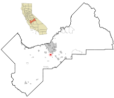
Coordinates: 36°39′01″N 119°47′27″W / 36.65028°N 119.79083°WCoordinates: 36°39′01″N 119°47′27″W / 36.65028°N 119.79083°W Country  United States
State  California
County Fresno Government – N/A – Senate Dean Florez (D) – Assembly Juan Arambula (D) – U. S. Congress Jim Costa (D) Area[1] – Total 3.011 sq mi (7.799 km2) – Land 3.011 sq mi (7.799 km2) – Water 0 sq mi (0 km2) 0% Elevation 276 ft (84 m) Population (2010) – Total 2,083 – Density 691.8/sq mi (267.1/km2) Time zone PST (UTC-8) – Summer (DST) PDT (UTC-7) ZIP code 93706 Area code(s) 559 FIPS code 06-20928 GNIS feature ID 0277503 Easton (formerly, Covel[2] and Covell[3]) is a census-designated place (CDP) in Fresno County, California, United States. The population was 2,083 at the 2010 census, up from 1,966 at the 2000 census. Easton is located 7.5 miles (12.1 km) south of downtown Fresno,[2] at an elevation of 276 feet (84 m).[3]
Contents
Geography
According to the United States Census Bureau, the CDP has a total area of 3.0 square miles (7.8 km2), all of it land.
History
Easton post office was established in 1881, moved in 1883, and closed in 1902.[2] It reopened in 1952.[2] The name honors O.W. Easton, land agent.[2]
Demographics
2010
The 2010 United States Census[4] reported that Easton had a population of 2,083. The population density was 691.7 people per square mile (267.1/km²). The racial makeup of Easton was 1,248 (59.9%) White, 13 (0.6%) African American, 58 (2.8%) Native American, 68 (3.3%) Asian, 0 (0.0%) Pacific Islander, 593 (28.5%) from other races, and 103 (4.9%) from two or more races. Hispanic or Latino of any race were 1,308 persons (62.8%).
The Census reported that 2,083 people (100% of the population) lived in households, 0 (0%) lived in non-institutionalized group quarters, and 0 (0%) were institutionalized.
There were 629 households, out of which 266 (42.3%) had children under the age of 18 living in them, 369 (58.7%) were opposite-sex married couples living together, 91 (14.5%) had a female householder with no husband present, 50 (7.9%) had a male householder with no wife present. There were 32 (5.1%) unmarried opposite-sex partnerships, and 5 (0.8%) same-sex married couples or partnerships. 102 households (16.2%) were made up of individuals and 46 (7.3%) had someone living alone who was 65 years of age or older. The average household size was 3.31. There were 510 families (81.1% of all households); the average family size was 3.66.
The population was spread out with 566 people (27.2%) under the age of 18, 231 people (11.1%) aged 18 to 24, 474 people (22.8%) aged 25 to 44, 532 people (25.5%) aged 45 to 64, and 280 people (13.4%) who were 65 years of age or older. The median age was 35.1 years. For every 100 females there were 104.0 males. For every 100 females age 18 and over, there were 101.7 males.
There were 667 housing units at an average density of 221.5 per square mile (85.5/km²), of which 423 (67.2%) were owner-occupied, and 206 (32.8%) were occupied by renters. The homeowner vacancy rate was 1.2%; the rental vacancy rate was 5.5%. 1,365 people (65.5% of the population) lived in owner-occupied housing units and 718 people (34.5%) lived in rental housing units.
2000
As of the census[5] of 2000, there were 1,966 people, 623 households, and 499 families residing in the CDP. The population density was 652.5 people per square mile (252.2/km²). There were 648 housing units at an average density of 215.1 per square mile (83.1/km²). The racial makeup of the CDP was 58.04% White, 0.61% Black or African American, 3.36% Native American, 3.97% Asian, 29.35% from other races, and 4.68% from two or more races. 51.78% of the population were Hispanic or Latino of any race.
There were 623 households out of which 35.2% had children under the age of 18 living with them, 62.3% were married couples living together, 12.4% had a female householder with no husband present, and 19.9% were non-families. 17.5% of all households were made up of individuals and 8.3% had someone living alone who was 65 years of age or older. The average household size was 3.16 and the average family size was 3.57.
In the CDP the population was spread out with 30.2% under the age of 18, 8.6% from 18 to 24, 24.8% from 25 to 44, 23.0% from 45 to 64, and 13.3% who were 65 years of age or older. The median age was 35 years. For every 100 females there were 102.3 males. For every 100 females age 18 and over, there were 95.7 males.
The median income for a household in the CDP was $31,172, and the median income for a family was $36,250. Males had a median income of $39,583 versus $21,071 for females. The per capita income for the CDP was $13,598. About 16.8% of families and 24.0% of the population were below the poverty line, including 37.7% of those under age 18 and 11.2% of those age 65 or over.
Notable residents
- Marjaree Mason, for whom Fresno County's Marjaree Mason Center is named, was born in Easton.
- Deshawn Stevenson, Basketball player for the Dallas Mavericks, lived in Easton.
References
- ^ U.S. Census
- ^ a b c d e Durham, David L. (1998). California's Geographic Names: A Gazetteer of Historic and Modern Names of the State. Quill Driver Books. p. 1030. ISBN 9781884995149.
- ^ a b U.S. Geological Survey Geographic Names Information System: Easton, California
- ^ All data are derived from the United States Census Bureau reports from the 2010 United States Census, and are accessible on-line here. The data on unmarried partnerships and same-sex married couples are from the Census report DEC_10_SF1_PCT15. All other housing and population data are from Census report DEC_10_DP_DPDP1. Both reports are viewable online or downloadable in a zip file containing a comma-delimited data file. The area data, from which densities are calculated, are available on-line here. Percentage totals may not add to 100% due to rounding. The Census Bureau defines families as a household containing one or more people related to the householder by birth, opposite-sex marriage, or adoption. People living in group quarters are tabulated by the Census Bureau as neither owners nor renters. For further details, see the text files accompanying the data files containing the Census reports mentioned above.
- ^ "American FactFinder". United States Census Bureau. http://factfinder.census.gov. Retrieved 2008-01-31.
Municipalities and communities of Fresno County, California Cities 
CDPs Auberry | Big Creek | Biola | Bowles | Calwa | Cantua Creek | Caruthers | Centerville | Del Rey | Easton | Fort Washington | Friant | Lanare | Laton | Malaga | Mayfair | Minkler | Monmouth | Old Fig Garden | Raisin City | Riverdale | Shaver Lake | Squaw Valley | Sunnyside | Tarpey Village | Three Rocks | Tranquillity | West Park
Unincorporated
communitiesAlder Springs | Arbios | Avocado | Balch Camp | Barstow | Benito | Big Bunch | Biola Junction | Bretz Mill | Broadview Farms | Burness | Burrel | Calflax | Camden | Cameo | Camp Sierra | Cecile | Cedar Crest | Cedar Grove | Cedarbrook | Cella | Chaney Ranch | Cincotta | Clint | Clotho | Conejo | Crabtree | Cromir | Deer Crossing | Dinkey Creek | Dora Belle | Dunlap | Edmiston | Elk | Elm View | Etheda Springs | Figarden | Five Points | Floyd | Giffen Cantua Ranch | Glorietta | Goldleaf | Goodmill | Gordon | Gravesboro | Helm | Herndon | Highway City | Hoffman Point | Hub | Hume | Hume Station | Humphreys Station | Huntington Lake | Ingle | Ivesta | Jamesan | Kanawyers | La Jolla Ranch | Lacjac | Lakeshore | Lerona | Levis | Locans | Lone Star | Marshall Junction | Mathews Mill | Mattei | Meadow Lakes | Mercey Hot Springs | Miley | Miramonte | Mono Hot Springs | Murietta Farm | Muscatel | Navelencia | New Auberry | Ockenden | Old Bretz Mill | Oleander | Ora | Oro Loma | Oxalis | Panoche Junction | Parkfield Junction | Piedra | Pilibos Ranch | Pinehurst | Pineridge | Prather | Pratton | Raco | Riverbend | Rock Haven | Rodgers Crossing | Rolinda | Sawmill Flat | Schilling | Shaver Lake Heights | Sierra Cedars | Sierra Sky Park | Snow Bend | Tarpey | Tollhouse | Trimmer | Turk | Uva | Vanguard | Wahtoke | Westhaven | Westside | Wildflower | Wineland | Wolf | Wood Ranch | Zediker
Indian
reservationsBig Sandy Rancheria | Cold Springs Rancheria | Table Mountain Rancheria
Ghost towns Andrews | Barton | Bender | Bridge | Bronge | Butler | Cadogan | Caldwell | Carlile | Carmelita | Coalinga Mineral Springs | Collins | Darwin | Dathol | Deseret | Dickerson | El Prado | Elkhorn Station | Eshel | Everts | Fargo | Fort Camp | Fresno Beach | Fresno City | Fruitvale | Garfield | Granz | Hawthorne's Station | Hayes | Kelso | Kingriver | Kingston | La Libertad | Last | Leroy | Letcher | Lillis | Marshall Station | McKenzie Spring | McMullin | Mendota Station | Millerton | Mountain Rest | Nares | Nevills | Oakhurst | Oleander | Peteras Mill | Pinedale | Pool's Ferry | Pool's Fort | Poso de Chane | Portal | Pueblo de las Juntas | Rancho de los Californios | Reka | Riverview | Robinson | Rogers | Rugg | Sanders | Sentinel | Sharpville | Shaver | Shipp | Smith's Ferry | Sparkville | Tarn | Temperance | Thermal | Tisechu | Vanris | Vino | Warsaw
Categories:- Census-designated places in Fresno County, California
- Populated places in California with Hispanic majority populations
- Populated places established in 1881


Wikimedia Foundation. 2010.