- 1983 Coalinga earthquake
-
1983 Coalinga earthquake 


Date May 2, 1983 Magnitude 6.5 Mw Depth 10 kilometers (6 mi) Epicenter 36°13′N 120°19′W / 36.22°N 120.32°W Countries or regions  United States
Landslides yes Casualties 94 injured. The 1983 Coalinga earthquake occurred on May 2, 1983 at exactly 23:42 UTC in Coalinga, California. The earthquake recorded 6.5 on the Richter scale. The earthquake was caused by an unknown fault buried under the surface.[1]
The Coalinga earthquake was felt from the Los Angeles area north to Susanville (Lassen County) and from the coast east to western Nevada. Through July 31, more than 5,000 aftershocks were recorded, of which 894 had a magnitude of 2.5 or larger. Most of the larger magnitude shocks were felt in Coalinga.[2]
Contents
Tectonics
The Coalinga earthquake was caused by an 0.5-meter uplift of the anticline ridge northeast of Coalinga, but surface faulting was not observed. Ground and aerial searches immediately after the earthquake revealed ground cracks and fissures within about 10 kilometers (6.2 mi) of the instrumental epicenter, none of which appeared to represent movement on deeply rooted fault structures. About five weeks later, on June 11, however, an aftershock caused surface faulting about 12 km (7.5 mi) northwest of Coalinga.[2]
The Coalinga earthquake suggested to geologists that the State of California was in even worse seismological condition than had been thought. The pace of earthquake activity along the Pacific coast was identified as a relevant subject for further study; and the investigation of earthquakes stemming from unknown faults caused concern.[3] California officials emphasized that the predicted great quake would do far more damage than this one and that if it struck in a densely populated area the damage would be incalculable.[4]
Damage and casualties
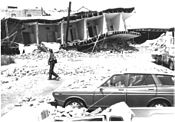 A building on 5th Street, Coalinga, California, destroyed by the May 2, 1983 earthquake. (Photograph by the Fresno Bee.)
This earthquake caused an estimated $10 million in property damage (according to the American Red Cross) and injured 94 people. Damage was most severe in Coalinga, where the 8-block downtown commercial district was almost completely destroyed. Here, buildings having unreinforced brick walls sustained the heaviest damage. Newer buildings, however, such as the Bank of America and the Guarantee Savings and Loan buildings, sustained only superficial damage. The most significant damage outside the Coalinga area occurred at Avenal, 31 kilometers (19 mi) southeast of the epicenter.[2]
A disaster assessment by the American Red Cross listed the following statistics on damage in the area: almost destroyed - 309 single-family houses and 33 apartment buildings; major damage - 558 single-family houses, 94 mobile homes, and 39 apartment buildings; and minor damage - 811 single-family houses, 22 mobile homes, and 70 apartment buildings. Most public buildings, including the City Hall, hospital, schools, fire house, post office, and police station, sustained only minor damage.[2]
Only six bridges of 60 surveyed in the area sustained measurable structural damage. This damage consisted of hairline cracks and spalling at the top of the support columns, fracturing and displacement of wing walls and parapets, and settlement of fill.[2]
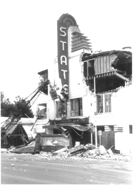
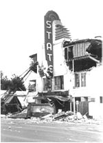 State Theater on Elm Avenue, Coalinga, California, damaged by the earthquake. (Photograph by the Fresno Bee.)
All public utilities were damaged to some degree. The water system continued to function despite many leaks in its transmission piping. Gas was shut off for several days because of broken piping and leaks, but only temporary interruptions of electric and telephone services were reported. One large section of old concrete sewer pipe west of the downtown area partly collapsed, but this system also continued to function.[2]
In the oil fields near Coalinga, surface facilities such as pumping units, storage tanks, pipelines, and support buildings were all damaged to some degree. One oil company administration building, about 7 km (4.3 mi) north of Coalinga, sustained major structural damage and its two brick chimneys were toppled. Subsurface damage, including collapsed or parted well casing, was observed only on 14 of 1,725 active wells.[2]
Mudslides and rockslides
This earthquake triggered thousands of rockfalls and rockslides as far as 34 km (21 mi) northwest, 15 km (9.3 mi) south, and 26 km (16 mi) southwest of the epicenter. Only a few slope failures occurred east of the epicenter because of the absence of steep slopes in that direction.[2]
Response
In response to the earthquake, the California Seismic Safety Commission was tasked with conducting a specific comprehensive investigation into the 1983 Coalinga earthquake, providing funding and expert technical assistance to the people of Coalinga for planning and reconstruction, and preparing and publishing a comprehensive report on the Coalinga earthquake.[5] Coalinga recovered 98 percent of their expenses in repairing and rebuilding public buildings at a time when an 85 percent recovery rate was considered the standard success rate.[6] In September 2006, the California Seismic Safety Commission was renamed the Alfred E. Alquist Seismic Safety Commission in honor of the then recently deceased California politician Al Alquist.[5] In addition, the commission member's per diem expenses were raised from $50 to $100 per day and their duties specific to the 1983 Coalinga earthquake were deleted before the comprehensive report was prepared.[5]
See also
- Earthquakes in California
- List of earthquakes in the United States
References
- ^ "Effects and occurrence of earthquake". bssa.geoscienceworld.org. http://bssa.geoscienceworld.org/cgi/content/abstract/75/2/475. Retrieved 2008-06-13.
- ^ a b c d e f g h "Earthquake's destruction". United States Geological Survey. http://earthquake.usgs.gov/regional/states/events/1983_05_02.php. Retrieved 2008-06-13.
- ^ Blakeslee, Sandra. "Lesson of Coalinga:California Seems in Still Greater Peril," New York Times. May 24, 1983.
- ^ Lindsey, Robert. "Lessons of 'Moderate" Coast Earthquake," New York Times. May 4, 1983.
- ^ a b c Senate Bill No. 1278 CHAPTER 532 An act to amend Sections of the Government Code relating to the Seismic Safety Commission. (September 28, 2006) Accessed June 14, 2008.
- ^ Borba, Jeanie; Diaz, Sam. (May 2, 1993) The Fresno Bee Coalinga - The town the quake built. Section: Telegraph; Page A1.
Further reading
 This article incorporates public domain material from the United States Government document "the United States Geological Survey".
Significant California earthquakes Very Large
(7.0 or greater)1857 Fort Tejon (7.9) · 1872 Lone Pine (7.8) · 1906 San Francisco (7.8) · 1952 Kern County (7.3) · 1992 Cape Mendocino (7.2) · 1992 Landers (7.3) · 1999 Hector Mine (7.1) · 2010 Baja California (7.2)
Large
(6.0-6.9)1868 Hayward (6.8) · 1933 Long Beach (6.4) · 1971 San Fernando (6.6) · 1983 Coalinga (6.5) · 1984 Morgan Hill (6.2) · 1986 Chalfant Valley (6.2) · 1989 Loma Prieta (6.9) · 1992 Big Bear (6.4) · 1994 Northridge (6.7) · 2003 San Simeon (6.5) · 2004 Parkfield (6.0) · 2010 Eureka (6.5)
Moderate
(less than 6.0)1987 Whittier Narrows (5.9) · 2007 Alum Rock (5.6) · 2008 Chino Hills (5.4)
Categories:- 1983 earthquakes
- Earthquakes in California
- History of Fresno County, California


Wikimedia Foundation. 2010.