- 1989 Loma Prieta earthquake
earthquake
title= Loma Prieta earthquake
date=October 17 ,1989 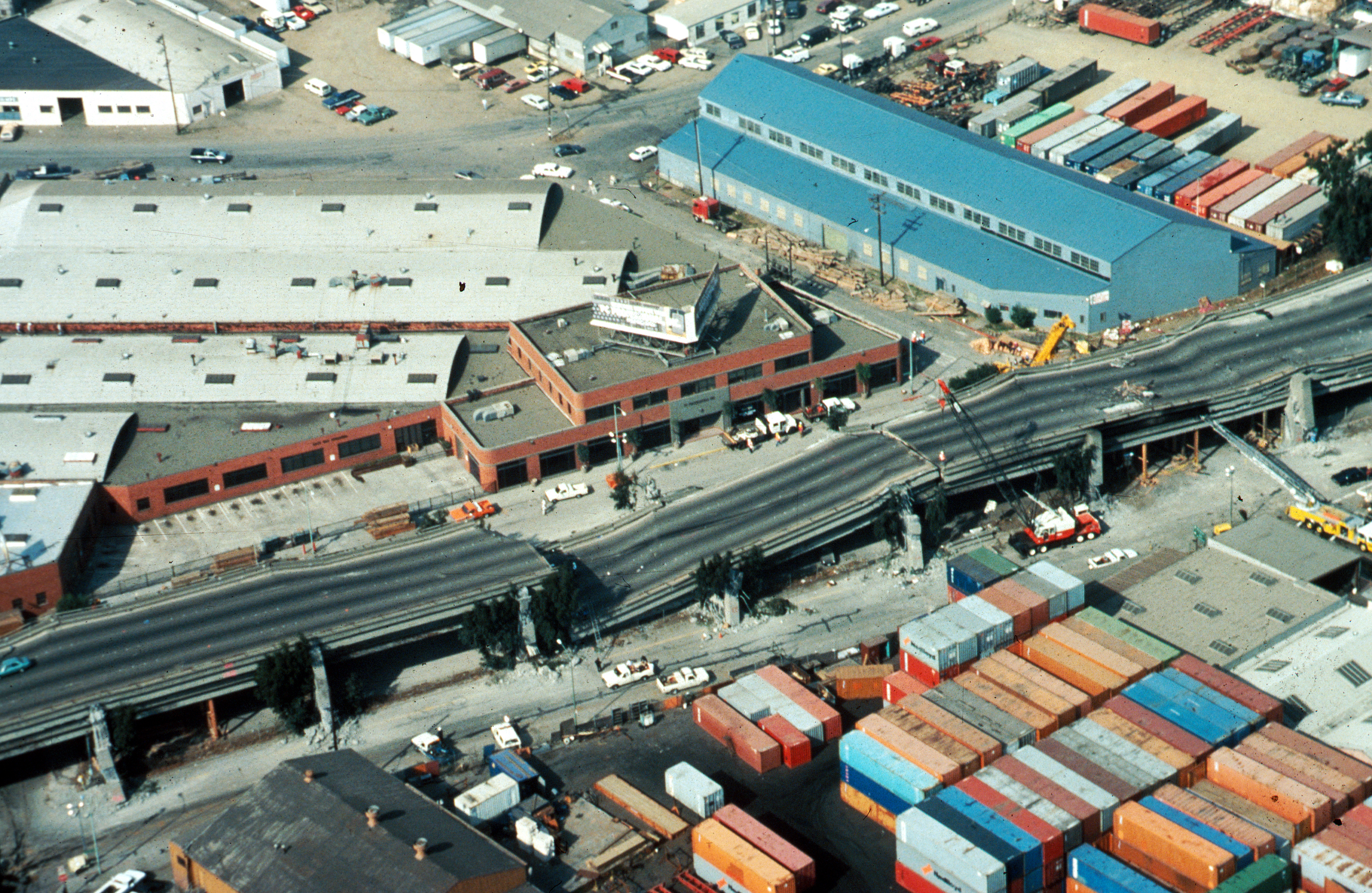
magnitude=6.9 Mw
depth=convert|18|km|mi|0
epicenter location=coord|37.04|-121.88)
countries affected=United States (San Francisco Bay Area )
location=Forest of Nisene Marks State Park ,California
intensity = VIII - Destructive
casualties=63 killedcite journal |author=Eberhart-Phillips JE, Saunders TM, Robinson AL, Hatch DL, Parrish RG |title=Profile of mortality from the 1989 Loma Prieta earthquake using coroner and medical examiner reports |journal=Disasters |volume=18 |issue=2 |pages=160–70 |year=1994 |month=Jun |pmid=8076160 |doi= |url=]The Loma Prieta earthquake, also known as the Quake of '89 and the World Series Quake, was a major
earthquake that struck theSan Francisco Bay Area ofCalifornia onOctober 17 ,1989 at 5:04 p.m. Caused by a slip along the San Andreas Fault, the earthquake lasted approximately 15 seconds and measured 6.9 on themoment magnitude scale (surface-wave magnitude 7.1). [ [http://pubs.usgs.gov/dds/dds-29/ USGS. "The October 17, 1989, Loma Prieta, California, Earthquake—Selected Photographs"] ] The quake killed 63 people throughout northern California, injured 3,757 people and left some 8,000 [ [http://www.sfgate.com/cgi-bin/article.cgi?file=/chronicle/archive/1999/10/17/SC05SC1.DTL SFGate.com. "AFTER THE FALL: The earthquake shattered the Bay Area, but the cities hardest hit are now mostly rebuilt -- and the scars are hidden deep below the surface". Carl Nolte, Chronicle Staff Writer. Sunday, October 17, 1999] ] to 12,000 people homeless. [ [http://www.sfmuseum.net/alm/quakes3.html#1989 San Francisco Earthquake History 1915-1989] ]The earthquake occurred during the warm up for the third game of the
1989 World Series , coincidentally featuring both of the Bay Area'sMajor League Baseball teams, theOakland Athletics and theSan Francisco Giants . This was the first major earthquake in America to be broadcast on live television.Epicenter
The
epicenter of the quake was inForest of Nisene Marks State Park in Santa Cruz County, an unpopulated area in theSanta Cruz Mountains (geographical coordinates coord|37.04|-121.88), approximately 4 km (2-3 miles) north of unincorporated Aptos and approximately 16 km (10 miles) northeast of Santa Cruz. The quake was named for the nearbyLoma Prieta Peak which lies 8 km (5 miles) to the northeast in Santa Clara County.
Photo by C.E. Meyer, USGSInjuries and fatalities
63 deaths were directly caused by the earthquake; six further deaths were ruled to be caused indirectly. In addition, there were 3,757 injuries as a result of the earthquake. The highest concentration of fatalities, 42, [cite web |url=http://home.pacbell.net/hywaymn/Cypress_Viaduct_Freeway.html |title=Cypress Viaduct Freeway] occurred in the collapse of the
Cypress Street Viaduct on theNimitz Freeway (Interstate 880), where a double-decker portion of the freeway collapsed, crushing the cars on the lower deck. One 50-foot (15 m) section of theSan Francisco – Oakland Bay Bridge also collapsed, causing two cars to fall to the deck below, leading to the single fatality on the bridge. The bridge was closed for repairs for a month and one day, reopening onNovember 18 . While the bridge was closed, ridership onBay Area Rapid Transit and ferry services soared, along with traffic levels on nearby bridges such as the San Mateo Bridge, Richmond-San Rafael and the Golden Gate.When the earthquake hit, Game 3 of the
1989 World Series baseball championship was just starting. Due to the unusual circumstance that both of the World Series teams (theSan Francisco Giants andOakland Athletics ) were based in the affected area, many people had left work early or were staying late to participate in after-work group viewings and parties. As a consequence, the usually crowded freeways were experiencing exceptionally light traffic. If traffic had been normal for a Tuesdayrush hour , injuries and deaths could have been higher. The initial media reports failed to take into account the game's effect on traffic and initially pegged the death toll at 300, a number that was corrected in the days after the earthquake. [cite web |url=http://news.bbc.co.uk/onthisday/hi/dates/stories/october/17/newsid_2491000/2491211.stm |title=1989: Earthquake hits San Francisco]
=DaThe earthquake caused severe damage throughout the San Francisco Bay Area, most notably in San Francisco and Oakland, but also in many other communities throughout the region, including Alameda, San Mateo, Santa Clara,
San Benito County , Santa Cruz, and Monterey counties. Major property damage in theMarina District 60 miles (95 km) from the epicenter resulted from liquefaction of soil used to fill waterfront properties. Other effects includedsand volcano es,landslide s, and ground ruptures. 18,306 homes and 2,575 businesses were damaged. In Santa Cruz, close to the epicenter, 40 buildings collapsed, killing at least six people.Given the distance between the quake's epicenter and some of the worst-hit areas, geologists were surprised at the severity of the resulting damage. Subsequent analysis indicated that the damage was due to the amplification of the earthquake's
Seismic waves by waves reflecting off the deep (about 24 km(15 miles)) discontinuities in the Earth's surface.The quake caused an estimated $6 billion to $13 billion in property damage, becoming one of the most expensive natural disasters in U.S. history at the time. It was the largest earthquake to occur on the
San Andreas Fault since the great1906 San Francisco earthquake . Private donations poured in to aid relief efforts and onOctober 26 , President George H.W. Bush signed a $3.45 billion earthquake relief package for California.Marina District

Photo by J.K. Nagata, USGS1906 San Francisco earthquake ), containing a high percentage ofgroundwater . This resulted inearthquake liquefaction , and the earthquake's shockwaves rippled the ground more severely. Multi-story buildings shook violently and many that had inadequately reinforced garages on the first floor had their heavy upper stories fall into that floor. In some instances, only the top floor was left intact, having spilled into the road, crushing parked cars, trees, and light poles.
Photo by J.K. Nagata, USGSFires raged in some sections of the city as water and gas mains broke. San Francisco's
fireboat (the "Phoenix") was used to pump salt water from San Francisco Bay through hoses dragged through streets by citizen volunteers. Power was cut to most of San Francisco and was not fully restored for several days.At the intersection of San Francisco's Beach and Divisadero Streets, a gas main rupture caused a major
structure fire . The fire department selected bystanders to help run fire hoses from a distance because the nearby hydrant system failed. Water from the bay was shot at the burning buildings byfireboat s similar to those used to put out fires caused by the 1906 earthquake. In collapsed buildings that did not catch fire, rescue teams searched the fallen buildings thoroughly, pulling out survivors from underneath splintered wood and other debris. Most of the apartment structures that collapsed were corner units, with garage doors lined up on the exposed corners. Not originally part of the buildings, but installed some time after the buildings were built, the garage doors weakened the first-story walls, causing the stiff, wood-frame buildings to buckle, crack, and crash into the streets. There were about five deaths from Marina District apartment fires and collapses. One family lost their baby boy who was trapped underneath their collapsed apartment.anta Cruz and Monterey Counties
[

Pacific Garden Mall suffered severe damage in the quake with several deaths occurring in collapsed masonry buildings.
Photo by C.E. Meyer, USGS] In Santa Cruz, thePacific Garden Mall was irreparably damaged, with falling debris killing three people. When the earthquake struck, the brick facades of the historic buildings tumbled into the streets, while buildings slammed against one another and crumbled in reaction to the lengthy . 31 buildings were ruined enough to warrant demolishing; seven of which had been listed in the Santa Cruz Historic Building Survey. The four oldest had been built in 1894; the five oldest had withstood the1906 San Francisco earthquake . [ [http://www.santacruzpl.org/history/disaster/dembldg.shtml Santa Cruz Public Libraries. Local History. "Buildings Demolished in Downtown Santa Cruz as a Result of the Damage from the 1989 Loma Prieta Earthquake"] ]Immediately, a large number of citizens began to work attempting to free victims from the rubble of Ford's Department Store and the Santa Cruz Coffee Roasting Company, both of which had collapsed inward on customers and employees alike. Two police officers crawling through voids in the debris found one victim alive and another dead inside the coffee house. Santa Cruz beach lifeguards assisted in moving the victims. Police dogs were brought in to help locate further victims. A woman was found dead inside Ford's. [ [http://www.santacruzpl.org/gallery2/v/lochistphotos/rs009.jpg.html Santa Cruz Public Libraries. Local History. Photograph Collection: rs009. "The front of Ford's Department Store on the corner of Pacific Avenue and Cathcart Street. A woman inside the store died from falling debris during the earthquake. Ford's was later razed." Date: October 18, 1989. Courtesy of Ray Sherrod.] ] At the coming of night, public search operations were called to a halt because of unsafe conditions, with fire department personnel continuing their primary search operations by flashlight and generator light. The citizens that had been initially helpful soon became seen by police and fire officials as a hindrance to operations, with frantic coworkers and friends of a coffee house employee who was considered trapped under the rubble continuing their efforts in the dark. [ [http://www.santacruzpl.org/history/disaster/citylog.shtml Santa Cruz Public Libraries. Local History. "Log of Emergency Response Operations. Tuesday, October 17, 5:04PM, 15-second earthquake!"] ] Police arrested those who refused to stop searching; this became a political issue in the coming days. [ [http://www.sfmuseum.org/1989/report.html sfmuseum.org. Edward J. Phipps. "Overview of Fire Service Responses near the Epicenter of the Loma Prieta Earthquake"] ] The body of the young woman coffee worker was found under a collapsed wall late the next day. [ [http://www.time.com/time/magazine/article/0,9171,958883-6,00.html "Time" magazine. Monday, Oct. 30, 1989. Ed Magnuson. "Earthquake (6 of 8)"] ]
During the first few days following the quake, power was out to most Santa Cruz county subscribers and some areas had no water. Cell phone service remained online, providing a crucial link to rescue workers. Widespread search operations were organized to find possible victims within fallen structures. As many as six teams of dogs and their handlers were at work identifying the large number of damaged buildings that held no victims.
There was significant structural damage to beachfront villas of Capitola Village, when the fireplaces and end-walls of a landmark row-style hotel collapsed onto the sidewalks. The quake claimed a number of lives in Watsonville. Many older wooden structures were knocked off of their foundations and collapsed. Many residents were displaced from their homes. The earthquake also destroyed several buildings in the Old Town district of Salinas. In Monterey, windows were shattered in many homes and businesses and several historical structures were damaged.
an Francisco – Oakland Bay Bridge
The
San Francisco – Oakland Bay Bridge suffered relatively minor damage, as a 50-foot (15 meter) section of the upper deck on the eastern side crashed onto the deck below. The quake caused the Oakland side of the bridge to shift 18 centimeters (7 inches) to the east, and caused the bolts of one section to shear off, sending the small part of the roadbed crashing down like a trapdoor. When that part of the bridge collapsed, a few upper deck motorists drove into the hole but landed safely on the lower deck. Traffic on both decks came to a halt, blocked by the section of roadbed. Police began unsnarling the traffic jam, telling drivers to turn their cars around and drive back the way they had come. Eastbound drivers stuck on the lower deck between the collapse andYerba Buena Island were routed up to the upper deck and westward back to San Francisco. A miscommunication made by police at Yerba Buena Island directed some of the drivers in the wrong direction; they were directed to the upper deck driving east toward the collapse site. One of the drivers didn't see the gap in time; the car plunged over the ledge and smashed onto the collapsed roadbed. The driver died and the passenger was seriously injured. [ [http://www.sfmuseum.org/hist2/presidio.html "An Oral History of the Presidio of San Francisco During the Loma Prieta Earthquake"] ] [cite news |first=Jack |last=Viets |title=They Drove Into Gwork=San Francisco Chronicle |publisher=The Chronicle Publishing Co |page=A21 |date=1989-10-27 ] The collapsed section was removed and replaced, and the bridge was re-opened on
November 18 .Interstate 880/Cypress Viaduct
The worst disaster of the earthquake was the collapse of the two level Cypress Section of Interstate 880 in West Oakland. Forty-two people died and many more were injured.
Built in the late 1950s, the Cypress Viaduct (a 1 1/2 mile stretch of the Interstate 880) was a double-decker freeway that was relatively innovative when it was first constructed. Because little attention had been paid to strengthening it in case of a major earthquake, the freeway was changed very little if at all from when it was built. Like the Marina District, the land the Cypress Viaduct was built on was simply filled
marsh land. When the earthquake hit, the shaking was amplified in those areas, causing more damage than would have normally occurred if the land werebedrock .[

rebar placement, the columns broke with ease, sending the structure down.
Photo by H.G. Wilshire, USGS] With the combination of outdated earthquake standards and unstable ground, the freeway buckled and twisted to its limits before the support columns failed and sent the upper deck crashing to the lower deck. In an instant, 41 people were crushed to death in their cars. Cars on the upper deck were tossed around violently, some of them flipped sideways and some of them dangling at the edge of the highway. Appearing as though a "bomb had been exploded on the structure," the gigantic freeway was in ruins, with chunks of concrete in the streets below, steelrebar twisting out, and thick smoke coming out from in between the pancaked roadbeds as a result of fires from exploding gas tanks. Nearby residents and factory workers came to the rescue, climbing onto the wreckage and pulling trapped people out of their mangled cars from under a four-foot gap in some sections. Employees from Pacific Pipe (a now-shuttered factory adjoining the freeway) drove heavy lift equipment to the scene and started using it to raise sections of fallen freeway enough to allow further rescue. Hard-hatted factory workers continued their volunteer operation without stopping night and day untilOctober 21 1989 when they were forced to halt as PresidentGeorge H. W. Bush and GovernorGeorge Deukmejian viewed the damage. [ [http://query.nytimes.com/gst/fullpage.html?res=950DE1D7143BF932A15753C1A96F948260&sec=&spon=&pagewanted=print New York Times.Oct 21 1989 "People Moving Gingerly As They Pick Up Pieces"] ]Although many of the people on the lower level died, there were some survivors. Two of these survivors were six-year-old Julio Bereumen and his eight-year old sister Cathy. The two children were in the backseat of their mother's car when the quake hit. Their mother and a family friend were killed instantly. Both children were rescued. Cathy suffered several facial injuries and Julio's right leg was amputated above the knee. Another survivor was 57-year old dock worker, Buck Helm, who miraculously survived in his crushed car for four days after the freeway collapsed. Sadly, Helm succumbed to his injuries less than a month later.
Rebuilding the freeway took eight years. In the meantime, traffic detoured through nearby I-980. Instead of replacing I-880 over the same ground,
Caltrans rerouted the freeway further west around the outskirts of West Oakland. Street-level Mandela Parkway now occupies the previous roadbed of the Cypress Structure.1989 World Series
The earthquake had been "predicted" in the morning edition of "
The San Jose Mercury News " in a column byKevin Cowherd (of "The Baltimore Sun "). He was discussing the fact that the Oakland Athletics and the San Francisco Giants were playing each other in the1989 World Series atCandlestick Park that day. The quote from his column read: "... these are two teams from California and God only knows if they'll even get all the games in. An earthquake could rip through the Bay Area before they sing the anthem for Game 3,"— which was precisely when the quake occurred.It is one of the few times that the onset of an earthquake of such magnitude has occurred during a live network television broadcast and as a result, the earthquake was seen around the world as it happened. The Series was being televised that year by U.S. network ABC. At the moment the quake struck, sportscaster
Tim McCarver was narrating taped highlights of the previous Series game. Viewers saw the video signal begin to break up, heard McCarver repeat a sentence as the shaking distracted him, and heard McCarver's colleague,Al Michaels exclaim, "I'll tell you what -- we're having an earth--." At that moment the feed from Candlestick Park was lost. The network put up a green ABC Sports graphic as the audio was switched to a telephone link. Michaels cracked, "Well folks, that's the greatest open in the history of television, bar none!" accompanied by the cheering of fans who had no idea of the devastation elsewhere. ABC then switched to their "rain delay" backup program, "Roseanne", while attempting to restore electricity to their remote equipment. After about 15 minutes, and with anchormanTed Koppel in position inWashington, D.C. , ABC began continuous news coverage. Michaels (who had extensive knowledge of the Bay Area from his time as a San Francisco Giants broadcaster), effectively became an on-scene reporter, narrating video shot by the ABC Sports cameras and theGoodyear Blimp from the safety of the TV truck. Michaels was later nominated for anEmmy Award for these news broadcasts.Fewer than half of the 65,000+ fans had reached their seats, lessening the load on the structure of the stadium. There had also been a seismic strengthening project previously completed on the upper deck concrete windscreen. Fans reported that the stadium moved in an articulated manner as the earthquake wave passed through it, that the light standards swayed by many feet, and that the concrete upper deck windscreen moved in a wave-like manner over a distance of several feet. As soon as the shaking stopped, the assembled crowd, unaware of the tragic destruction just beginning to be revealed around the rest of the Bay Area, roared loudly. A few minutes later they yelled "Let's play Ball, Let's play Ball!" However, a power outage forced the game to be postponed and the series did not resume for 10 days.
After the shaking subsided, many of the players for both the Athletics and Giants immediately searched for and gathered family and friends from the stands (while still in full uniform) before evacuating the facility altogether.
KGO-TV , the ABC owned-and-operated station in San Francisco was the first of the local Bay Areatelevision network affiliates to cover the earthquake after the game was postponed (soon afterward, all of the major network stations broadcast continuously for several hours without interruption, providing live news reports and updates) and the coverage was aired live through ABC News.Because of the importance of the World Series as a national sporting event, many members of local, regional and national broadcast media were in attendance and would later broadcast their observations of the aftermath of the earthquake to viewers around the world.
Other notable events
The
Goodyear blimp , in San Francisco to cover theWorld Series , was the first blimp to be airborne over the location of a major earthquake. The pilots of the blimp reported that the blimp bounced during the quake (confirmed by onboard sensors and cameras) almost as if it were on the ground, the first confirmation that the air column above an earthquake is affected by the movement of the ground underneath.Once the quake ended, the Goodyear blimp became the primary source of visual information, as Bay Area airports were closed. The blimp was the first to report the collapsed section of the Bay Bridge as well as many other major collapses and surveys of damaged areas. The information that the blimp's pilots and cameras provided to emergency workers was crucial to locate the areas of greatest need.
Effects on transportation
The Loma Prieta earthquake irrevocably changed the San Francisco Bay Area's transportation landscape. Not only did the quake force
seismic retrofitting of allSan Francisco Bay Area bridges, it caused enough damage that some parts of the region's freeway system had to be demolished. In some cases, the freeways in question had never been completed, terminating in mid-air; in that regard, the quake provided the impetus to deal with regional transportation problems that had gone largely unsolved for decades.
*San Francisco – Oakland Bay Bridge , Interstate 80: The Bay Bridge was repaired and reopened to traffic in just one month. However, the earthquake made it clear that the Bay Bridge, like many of California's toll bridges, required major repair or replacement, for long-term viability and safety. Construction on a replacement for the eastern span would not begin, however, untilJanuary 29 ,2002 . As of 2005, news accounts estimate that the project will not be completed by 2011 due to the California budget crisis. (For discussion, see alsoSan Francisco – Oakland Bay Bridge ).
*Cypress Street Viaduct /Nimitz Freeway , Interstate 880: The double-deckedCypress Street Viaduct , Interstate 880 was demolished soon after the earthquake, and was not rebuilt until July 1997. The rebuilt highway was a single- rather than double-decker structure, and was re-routed around the outskirts ofWest Oakland , rather than bisecting it, as theCypress Street Viaduct did. The former route of theCypress Street Viaduct was reopened as the Mandela Parkway.
*Embarcadero Freeway , State Route 480: The earthquake forced the closure and demolition of San Francisco's largely unlovedEmbarcadero Freeway (State Route 480); this demolition opened up San Francisco's Embarcadero waterfront to new development. The concrete freeway, which ran right along San Francisco's waterfront and had never been completed, was replaced with a ground-level boulevard.
* Southern Freeway, Interstate 280: Seismic damage also forced the long-term closure of Interstate 280 in San Francisco (north of US 101), another concrete freeway which had never been completed to its originally planned route. The highway remained closed for seven years, with its repair facing numerous delays.
*Central Freeway , U.S. Route 101: San Francisco's Central Freeway (part of US 101 and a key link to the Bay Bridge skyway) was another concrete double-deck structure which faced demolition due to safety concerns. Originally terminating at Franklin Street and Golden Gate Avenue near San Francisco's Civic Center, the section past Fell Street was demolished first, then later the section between Mission and Fell Streets. The section from Mission Street to Market Street was rebuilt (completed September 2005) as a single-deck elevated freeway, touching down at Market Street and feeding intoOctavia Boulevard , a ground-level urban parkway carrying traffic to and from the major San Francisco traffic arterials that the old elevated freeway used to connect to directly, including Fell and Oak Streets (which serve the city's western neighborhoods) and Franklin and Gough Streets (which serve northern neighborhoods and the Golden Gate Bridge).
* State Route 17: The mountain highway was closed for about 1 month due tolandslide . The highway is very close to the epicenter and it crosses theSan Andreas Fault . State Route 1 collapsed in western Watsonville over Struve Slough.
Photo by J.C. Tinsley, USGS
* State Route 1: In Watsonville, the Struve Slough bridge collapsed on itself with concrete/steel support columns punching through the bridge deck like toothpicks. The highway was closed for several months until it could be demolished and rebuilt. Another section of Highway 1 through Monterey had to be rebuilt following the earthquake as well. Additionally, the bridge carrying Highway 1 over theSalinas River nearFort Ord was damaged and subsequently rebuilt.
*Bay Area Rapid Transit : The BART rail system, which hauled commuters between the East Bay andSan Francisco via theTransbay Tube , was virtually undamaged and only closed for post-earthquake inspection. With the Bay Bridge closed due to damage, the Transbay Tube became the quickest way into San Francisco via Oakland for a time, and ridership increased by 90,000 in the week after the earthquake (from 218,000 to 308,000).
* Transbay Ferries: Ferry service between San Francisco and Oakland, which had ended decades before, was revived during the month-long closure of the Bay Bridge as an alternative to the overcrowded BART. Alameda was a third terminal. The passenger-only service proved popular and still continues as of2008 , with a more recent extension to Vallejo onSan Pablo Bay .cience of the earthquake
Magnetic disturbances
The Loma Prieta earthquake was preceded by significant disturbances in the background
magnetic field strength nearby. Large increases inextremely low frequency field strength were observed about 7 kilometers from the epicenter, up to two weeks in advance of the actual event. The measurement instrument was a single-axis search-coilmagnetometer that was being used for research on radio communications withsubmarines by Prof. Antony C. Fraser-Smith ofStanford University . Signal strengths 20 times higher than normal were observed onOctober 3 , rising to 60 times normal about three hours before the earthquake. [http://www-star.stanford.edu/~acfs/LomaPrietaPaper.pdf]Geological data anomalies
A prediction of the Loma Prieta earthquake, by retired geologist
Jim Berkland of the U.S. Geological Survey, appeared in a newspaper article four days before the event. The article, entitled "Is 'World Series' Quake Coming?", was published in the "Gilroy Dispatch" on13 October 1989 .Berkland based his predictions on anomalies in tidal information, gravitational data, animal behavior, and other sources. [Cal Orey, "The Man Who Predicts Earthquakes: Jim Berkland, Maverick Geologist--How His Quake Warnings Can Save Lives", (Sentient Publications), ISBN 1-59181-036-1.]
In fiction, media
* "After The Shock" (1990), TV movie with stories of rescue after the disaster. [ [http://www.imdb.com/title/tt0098995/ IMDb. "After the Shock" (1990)] ]
* "Miracle on Interstate 880" (1993), TV movie fictionalization and re-enactment of events at the Cypress Structure. [ [http://www.imdb.com/title/tt0107578/ IMDb. "Miracle on Interstate 880" (1993)] ]ee also
*
1906 San Francisco Earthquake
*1994 Northridge Earthquake
*Earthquake engineering References
Seismology
* [http://earthquake.usgs.gov/regional/states/events/1989_10_18.php USGS: Loma Prieta]
** [http://earthquake.usgs.gov/1906/simulations/movies/lp1989plan.mov Simulation of Mercalli Scale ground motion presented as a 75 second animation] (Low-Res Quicktime)
** [http://earthquake.usgs.gov/1906/simulations/movies/lp1989plan_hires.mov Simulation of Mercalli Scale ground motion presented as a 75 second animation] (High-Res Quicktime)
* [http://web.archive.org/web/20051119051422/http://neic.usgs.gov/neis/states/california/loma_prieta.html USGS list of additional Loma Prieta sites]
* [http://pubs.usgs.gov/dds/dds-29/ Selected USGS photographs from the Loma Prieta earthquake]
* [http://geopubs.wr.usgs.gov/fact-sheet/fs151-99/ Progress Toward a safer future since the 1989 Loma Prieta Earthquake]
* [http://earthquake.usgs.gov/regional/states/events/1989_10_18.php/ Additional information on the Loma Prieta Earthquake]
* [http://www-star.stanford.edu/~acfs/ Prof. Antony C. Fraser-Smith, low-frequency electromagnetic precursors to earthquakes]
* [http://www.agu.org/pubs/crossref/2008/2007JB005265.shtml/ Coseismic sediment deformation during the 1989 Loma Prieta earthquake]
Wikimedia Foundation. 2010.