- Cypress Street Viaduct
-
Cypress Street Viaduct

Cypress Freeway, Nimitz Freeway Route information Maintained by Caltrans Length: 1.78 mi (2.86 km) History: 1957-1984 as  SR 17, 1984-89 as
  I-880
I-880Major junctions North end: 
 I-80 / I-580 in Oakland
South end: Market Street at 7th Street in Oakland Highway system Auxiliary route of the Interstate Highway System
Main • Auxiliary • BusinessState highways in California(list • pre-1964)
History • Unconstructed • Deleted • Freeway • ScenicThe Cypress Street Viaduct, often referred to as the Cypress Structure, was a 1.6 mile long, raised two-tier, multi-lane (four lanes per deck) freeway constructed of reinforced concrete that was originally part of the Nimitz Freeway (State Highway 17, and later, Interstate 880) in Oakland, California.
It replaced an earlier single-deck viaduct constructed in the 1930s as one of the approaches to the San Francisco – Oakland Bay Bridge. It was located along Cypress Street between 7th Street and Interstate 80 in the West Oakland neighborhood.
It officially opened to traffic on June 11, 1957 and was in use until the Loma Prieta earthquake occurred on October 17, 1989, when much of the upper tier collapsed onto the lower tier resulting in 42 fatalities.[1]
Contents
Construction
The double-decked viaduct was initially designed in 1949 by the City of Oakland as a way to ease traffic on local streets leading to the Bay Bridge, such as Cypress Street (which was California State Route 17 at the time).
The southernmost portion of the Cypress Street viaduct, which was designed as a central offramp structure exiting at Market Street between Fifth and Sixth Streets to the Eighth Street/Seventh Street on/off ramps, was the first phase of the overall project completed in October, 1955 by contractors Frederickson and Watson at a cost of $1.7 million. Construction on the second phase of the project, the double-decked viaduct portion (which started from Adeline Street in the south to the Bay Bridge Distribution Structure in the north), began in February, 1956 by contractors Grove, Wilson, Shepard and Kruge at a cost of $8.3 million, bringing the total cost of the viaduct project to $10 million. It was touted as the first double-decked viaduct when it officially opened to traffic on June 11, 1957.
Loma Prieta earthquake
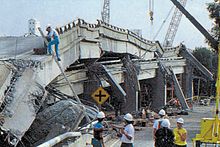
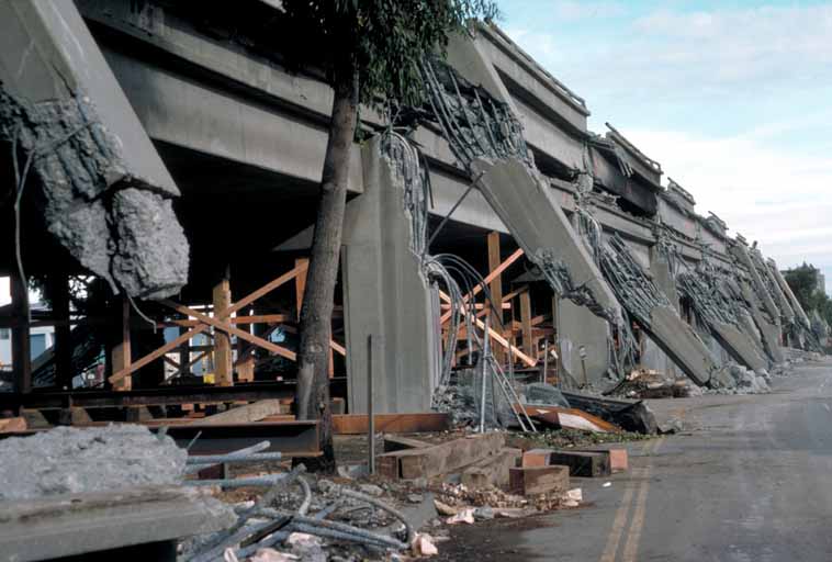
On October 17, 1989, the portion of the structure from 16th Street north all the way to the MacArthur Maze collapsed during the Loma Prieta earthquake, due to ground saturation and structural flaws.
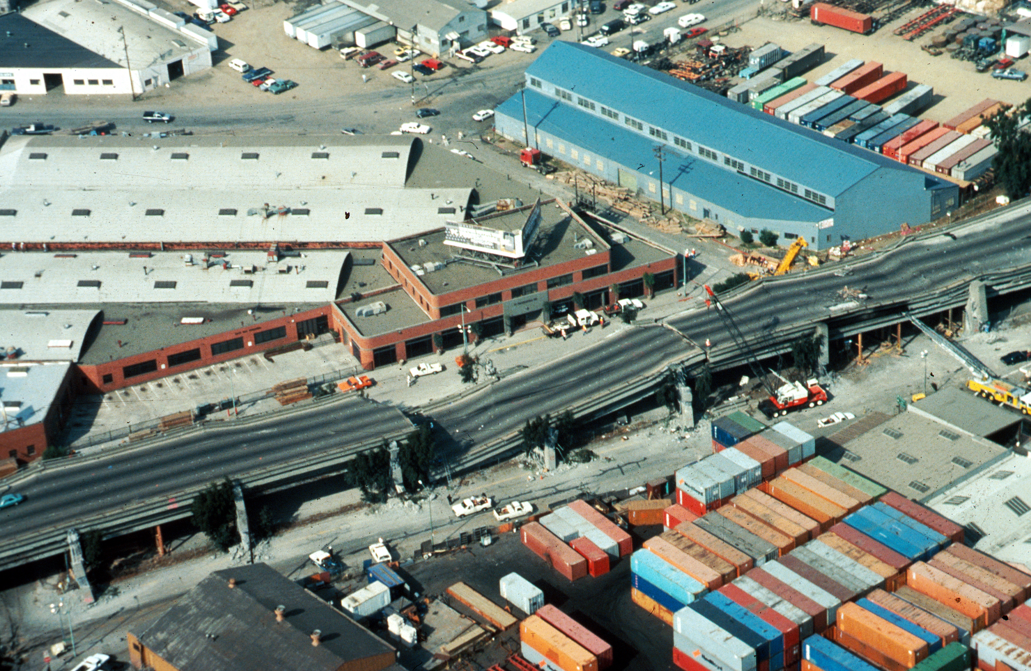
 The collapsed Cypress Street Viaduct at the Northern end, near the corner of Cypress and 32nd Streets.
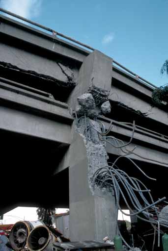
When it was in use, the upper tier was used by southbound traffic, and the lower tier was used by northbound traffic. Some sections of the Cypress Street Viaduct were largely supported by two columns on either side, but some sections were only supported beneath by a single supporting column. The design was unable to survive the earthquake because the upper portions of the exterior columns were not tied by reinforcing to the lower columns, and the columns were not sufficiently ringed to prevent bursting. At the time of its design, such structures were not analyzed as a whole, and it appears that large structure motion contributed to the collapse. It was built on filled land, which is highly susceptible to soil liquefaction during an earthquake and exhibits larger ground motion.
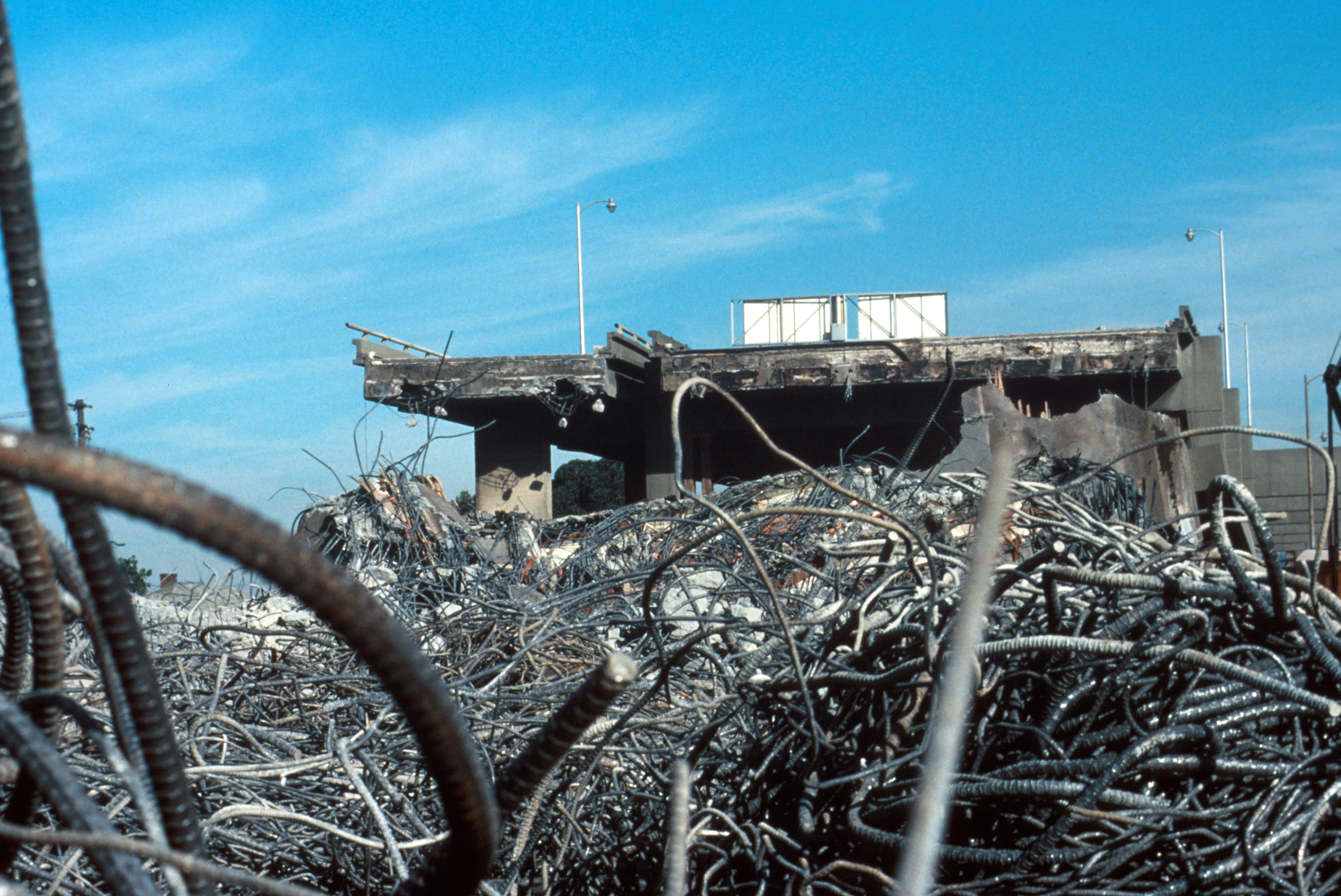
After the earth stopped moving, local residents and workers began crawling into and climbing upon the shattered structure with the goal of rescuing those left alive. Many were saved; some only by amputation of trapped limbs.[2] The collapse of the upper tier onto the lower tier resulted in 42 fatalities—two-thirds of the total quake death toll of 63.[3]
The viaduct was torn down, Cypress Street was renamed (now known as Mandela Parkway, in honor of Nelson Mandela) with a landscaped median planted where the viaduct once stood. Before reconstruction occurred, the viaduct ended at the Eighth Street exit on the southern end, with the two roadways going over Seventh Street, while the southbound exit off the MacArthur Maze onto Cypress Street at 32nd Street remained open to local traffic on the northern end.
Reconstruction around West Oakland
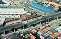
In 1997, the Nimitz Freeway was rerouted to loop around the area using a largely ground-level design with more conventional single-level viaduct. The space was mainly taken from a railroad yard which was relocated. The exit at Eighth Street was eliminated, a southbound exit near Seventh and Union Street and a single northbound and southbound exit at Seventh Street, near the Port of Oakland was constructed also providing access via a frontage road to Grand Avenue and the Oakland Army Base, before a viaduct-type interchange splitting traffic to the Bay Bridge via Grand Avenue and also northbound to the Eastshore Freeway.
During construction of the new section of the Nimitz Freeway, a team of archaeologists made many interesting discoveries about the people who lived in West Oakland in the 19th century.[4]
Due to cost overruns, the costs of the replacement freeway doubled from initial estimates of $650 million to $1.25 billion ($250 million per mile) making the five-mile freeway replacement the most expensive project in the state's history at the time. (It would be subsequently overshadowed by the northbound addition of the Benicia Bridge and the Eastern span replacement of the San Francisco-Oakland Bay Bridge.) The cost overruns were mainly due to the opposition to replacing the highway on the site of the one partially destroyed in 1989, having to purchase land and property from Southern Pacific Railroad and Amtrak (moving part of the rail yard, and causing the earthquake-damaged 16th Street Amtrak Station to be closed and replaced with two Amtrak stations in Jack London Square and Emeryville), the United States Postal Service (having to replace a parking lot with a parking garage), also replacing BART support beams and purchasing land from the U.S. Army (the freeway went through the Oakland Army Base to re-route the freeway).
Exit list
The following is an exit list of the former Cypress Viaduct/Nimitz Freeway prior to the Loma Prieta earthquake and subsequent demolition.
The entire route was in Oakland.
Interchange Notes Southern End of Viaduct ( I-880, continued to/from Downtown Oakland and San Jose)Market Street, Harbor Terminal Southbound and Northbound exit and entrance 8th Street, Cypress Street Northbound exit 7th Street at Kirkham Street Southbound entrance 14th Street, Downtown Oakland Northbound entrance and Southbound exit Cypress Street, Peralta Street Southbound exit Cypress Street at 32nd Street Northbound entrance I-580 – San RafaelNorthbound exit and Southbound Entrance I-80 – San Francisco, SacramentoNorthbound/Westbound exit and Southbound/Eastbound Entrance Northern End of Viaduct ( I-80/ I-580/ I-880, The MacArthur Maze)Gallery
-
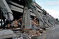
The collapsed Cypress Street Viaduct seen from ground level. Note the detachment of upper vertical elements from lower and the lack of reinforcement at the point of detachment.
-
Portion of the collapsed Cypress Street Viaduct after the Loma Prieta Earthquake; the collapse resulted in 42 fatalities.
-
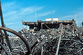
A pile of rebar and concrete from the collapsed Cypress Street Viaduct
-

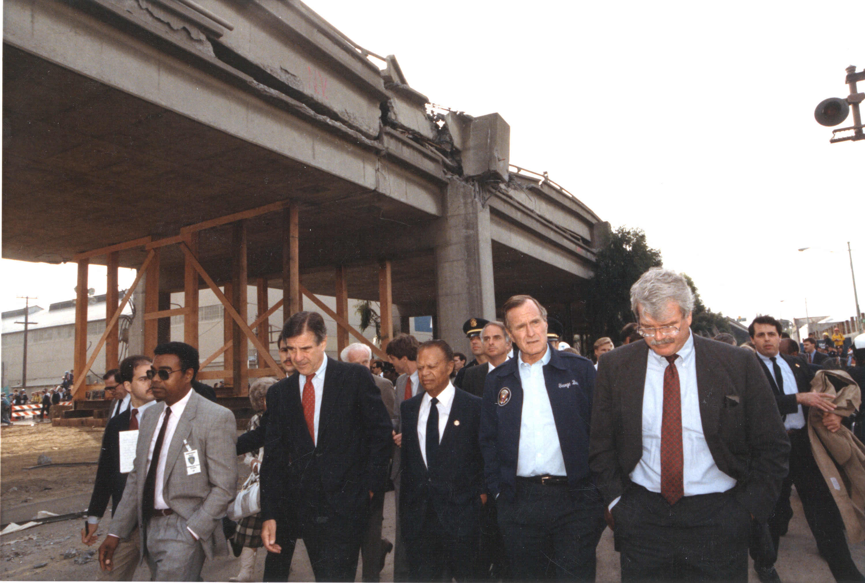
President George H. Bush inspects Cypress Street Viaduct damage.
Similar structures damaged by earthquakes
- Alaskan Way Viaduct (not destroyed)
- Central Freeway
- Embarcadero Freeway
- Hanshin Expressway
References
- ^ "Cypress Viaduct Freeway". http://home.pacbell.net/hywaymn/Cypress_Viaduct_Freeway.html.
- ^ Holler, Scott; Vicki Sheff, Lorenzo Benet, Doris Bacon, Tom Cunneff, Michael Alexander, Kristina Johnson, Robin Micheli, Linda Witt (October 30, 1989). "A City Trembled, Its People Held". People 32 (18). http://www.people.com/people/archive/article/0,,20121526,00.html.
- ^ Eberhart-Phillips JE, Saunders TM, Robinson AL, Hatch DL, Parrish RG (June 1994). "Profile of mortality from the 1989 Loma Prieta earthquake using coroner and medical examiner reports". Disasters 18 (2): 160–70. doi:10.1111/j.1467-7717.1994.tb00298.x. PMID 8076160.
- ^ "Putting the "There" There: Historical Archaeologies of West Oakland". http://www.sonoma.edu/asc/cypress/finalreport/index.htm. Retrieved 2007-11-03.
External links
- Miracle on Interstate 880 (1993), TV movie fictionalization and re-enactment of events at the Cypress Structure.
- Loma Prieta Earthquake, ca. 1989 (03/2003 - ). National Archives and Records Administration - ARC Identifier 951729 / Local Identifier 311-NETC-39 - Department of Homeland Security. Federal Emergency Management Agency. National Emergency Training Center.
- Construction of the Cypress Viaduct (part 1 of 5) (1950s), Caltrans video showing the progress of construction and engineering methods used.
San Francisco Bay Area Freeways Italics denote former routes.Interstates and U.S. Routes I-80 (James Lick / Eastshore / San Francisco Skyway) · US 101 (South Valley / Bayshore / Redwood Highway / Central) · I-238 · I-280 (Junipero Serra / Southern / Sinclair) · I-380 (Kopp) · CA 480 (Embarcadero) · I-580 (MacArthur) · I-680 (Sinclair) · I-780 · I-880 (Nimitz Freeway) · I-980 (Grove-Shafter)
California State Routes CA 1 (Cabrillo Highway) · CA 4 (John Muir Parkway) · CA 12 (Burbank Freeway) · CA 13 (Warren Freeway) · CA 17 (Santa Cruz Highway) · CA 24 (Grove-Shafter Freeway) · CA 29 (Vallejo-Napa Freeway) · CA 37 (Sears Point Freeway/Marine World Parkway) · CA 84 (Dumbarton Bridge) · CA 85 (West Valley Freeway) · CA 87 (Guadalupe Freeway) · CA 92 (San Mateo-Hayward Bridge/Younger Freeway) · CA 160 (Antioch Bridge) · CA 237 (South Bay Freeway) · CA 242 (Concord Freeway)Named interchanges Bridges Golden Gate Bridge · San Francisco – Oakland Bay Bridge · San Mateo – Hayward Bridge · Dumbarton Bridge · Richmond – San Rafael Bridge · Carquinez Bridge · Benicia–Martinez Bridge · Antioch BridgeSee also Coordinates: 37°49′00″N 122°17′22″W / 37.8168°N 122.2895°W
Categories:- History of Oakland, California
- San Francisco Bay Area freeways
- Transportation in Oakland, California
- Demolished highways in the United States
- Bridge disasters in the United States
- Bridge disasters caused by earthquakes
- Bridges in the San Francisco Bay Area
- 1989 in the United States
- Viaducts in the United States
- Road bridges in California


Wikimedia Foundation. 2010.