California State Route 242
- California State Route 242
Infobox road
state=CA
type=SR
route=242
section=542
maint=Caltrans
length_mi=3.58
length_round=2
length_ref=[ [http://www.dot.ca.gov/hq/structur/strmaint/brlog2.htm January 1, 2006 California Log of Bridges on State Highways] ] ]
direction_a=South
terminus_a=jct|state=CA|I|680 in Concord
direction_b=North
terminus_b=jct|state=CA|SR|4 in Concord
previous_type=SR
previous_route=241
next_type=SR
next_route=243
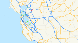
State Route 242 is a short three-mile (5 km) connector route that links Interstate 680 north of Pleasant Hill to State Route 4 in Concord. In 2000, State Route 242 was widended to six through-traffic lanes for the entire route. Ramp metering is present at all onramps, but is not used at this time. It was signed as part of State Route 24 until ca. 1987. Currently, along with Interstate 580, State Route 24, Interstate 680, and State Route 4, it serves as the most direct route between the San Francisco Bay Area and the Sacramento River Delta region of Northern California.
This route is part of the California Freeway and Expressway System[ [http://www.leginfo.ca.gov/cgi-bin/displaycode?section=shc&group=00001-01000&file=250-257 CA Codes (shc:250-257)] ] .]Exit list
:"Note: Except where prefixed with a letter, postmiles were measured in 1964, based on the alignment as it existed at that time, and do not necessarily reflect current mileage."The entire route is in Concord, Contra Costa County.
References
External links
* [http://www.dot.ca.gov/hq/roadinfo/sr242 Caltrans: Route 242 highway conditions]
* [http://www.cahighways.org/241-248.html#242 California Highways: Route 242]
Wikimedia Foundation.
2010.
Look at other dictionaries:
California State Route 24 — Infobox road state=CA type=SR route=24 section=324 maint=Caltrans length mi=13.53 length ref= [http://www.dot.ca.gov/hq/structur/strmaint/brlog2.htm January 1, 2006 California Log of Bridges on State Highways] ] length round=2 established=1934… … Wikipedia
California State Route 1 — For other uses, see CA1 (disambiguation). State Route 1 Route information … Wikipedia
California State Route 13 — CA 13 redirects here. For the congressional district, see California s 13th congressional district. For the original Sign Route 13, see California State Route 13 (1934). State Route 13 … Wikipedia
California State Route 241 — Infobox road state=CA type=SR route=241 alternate name=Foothill Toll Road, length mi=23 length round=3 length ref= established= 1993 direction a=South terminus a=Oso Parkway in Rancho Santa Margarita junction=jct|state=CA|SR|133 in Irvine… … Wikipedia
California State Route 85 — State Route 85 West Valley Freeway … Wikipedia
California State Route 92 — State Route 92 Route information … Wikipedia
California State Route 237 — State Route 237 Southbay Freeway … Wikipedia
California State Route 4 — For other uses, see CA4 (disambiguation). State Route 4 Route information … Wikipedia
California State Route 243 — Infobox road state=CA type=SR route=243 alternate name=Banning Idyllwild Panoramic Highway section=543 maint=Caltrans length mi=30 length round=0 length ref= [ [http://www.dot.ca.gov/hq/structur/strmaint/brlog2.htm January 1, 2006 California Log… … Wikipedia
California State Route 244 — Infobox road state=CA type=SR route=244 section=544 maint=Caltrans length mi=1.08 length ref= [http://www.dot.ca.gov/hq/structur/strmaint/brlog2.htm January 1, 2006 California Log of Bridges on State Highways] ] length round=2 established=July 1 … Wikipedia
