- Interstate 580 (California)
Infobox road
state=CA
type=I
route=580
alternate_name=Eastshore Freeway, MacArthur Freeway, Brown Freeway
section=618
maint=Caltrans 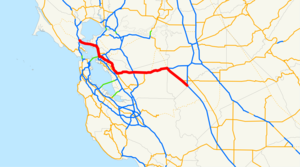
length_mi=79.97
length_round=2
length_ref=Fact|date=December 2007
established=August 7 ,1947 by FHWA [http://cahighways.org/itypes.html California Highways: Interstate Highway Types and the History of California's Interstates] ]July 1 ,1964 byCaltrans [http://www.cahighways.org/466-740.html#580 California Highways: Interstate 580] ]
direction_a=West
terminus_a=Jct|state=CA|US|101 in San Rafael
junction=Jct|state=CA|I|80|I|880 in Oakland Jct|state=CA|I|238 near Hayward Jct|state=CA|I|680 in Dublin jct|state=CA|SR|84 near Livermore
direction_b=East
terminus_b=Jct|state=CA|I|5 near Tracy
previous_type=I
previous_route=505
next_type=I
next_route=605Interstate 580 (I-580) is an
interstate highway in NorthernCalifornia . The heavily traveled, 80-mile (129 km) longspur route of Interstate 80 connects theSan Francisco Bay Area to Interstate 5 in the state's Central Valley.A portion of I-580 is called the MacArthur Freeway, after General
Douglas MacArthur . Other portions are named the John T. Knox Freeway (after a former California State Assemblyman and Speaker Pro Tempore), theEastshore Freeway (after its location onSan Francisco Bay ), the Arthur H. Breed Jr. Freeway (after a former California State Assemblyman and Senator), and the William Elton "Brownie" Brown Freeway (after a Tracy resident instrumental in determining the route of Interstate 5 through theSan Joaquin Valley )x] .This route is part of the
California Freeway and Expressway System [http://www.leginfo.ca.gov/cgi-bin/displaycode?section=shc&group=00001-01000&file=250-257 CA Codes (shc:250-257)] ] and is eligible for the State Scenic Highway System [http://www.leginfo.ca.gov/cgi-bin/displaycode?section=shc&group=00001-01000&file=260-284 CA Codes (shc:260-284)] ] .Route description
The western terminus of I-580 is north of San Francisco in San Rafael, at a junction with U.S. Route 101. The eastern terminus is with I-5 southeast of Tracy. Leaving San Rafael, I-580 runs next to the
San Quentin State Prison before crossingSan Francisco Bay over theRichmond-San Rafael Bridge . The road then passes through Richmond.In Albany, I-580 joins I-80 and then turns east at the interchange known as the
MacArthur Maze . From here, it is known as the MacArthur Freeway which runs through Oakland and San Leandro to Castro Valley. About halfway to Castro Valley from the Maze, is an interchange with theWarren Freeway (State Route 13). Between this interchange and Castro Valley, I-580 runs near or along the trace of theHayward Fault , a major branch of theSan Andreas Fault .In Castro Valley, I-580 turns eastward toward Dublin Canyon before descending into Dublin and Pleasanton. After passing through Livermore, the freeway enters the
Altamont Pass . The road emerges in the Central Valley near Tracy, where, after Interstate 205 splits near theAltamont Speedway , it turns southeastward and terminates by merging with Interstate 5 near Patterson.I-580 provides interstate highway access between
San Francisco andLos Angeles since Interstate 5 runs east of the Bay Area.Truck ban through Oakland
Trucks over 4.5
ton s are prohibited through Oakland between Grand Avenue and the San Leandro border. Specifically, eastbound trucks cannot travel beyond the Grand Avenue/Lakeshore Avenue exit, and those going westbound must take the MacArthur Boulevard/Foothill Boulevard exit. [http://www.dot.ca.gov/hq/traffops/trucks/trucksize/restrict-hist-580.htm Interstate 580 Truck Restriction History] , Caltrans.] They are instead instructed to take Interstate 238 and Interstate 880 as an alternative route through Oakland.The truck prohibition has been in effect since the freeway was built in 1963 as part of U.S. 50. Both the
Federal Highway Administration (FHWA) and theCalifornia Department of Transportation (Caltrans) imposed the restriction, partly because the City of Oakland already had a truck ban through the area prior to the freeway's construction. Since then, the restriction was grandfathered in when the freeway was both renumbered and added to the Interstate Highway System.For decades, the trucking industry lobbied to have the ban removed, but was unsuccessful due to local opposition. In 2000, the
California State Legislature passed Assembly Bill 500, adding the I-580 truck restriction into the California Vehicle Code. [ [http://www.leginfo.ca.gov/pub/99-00/bill/asm/ab_0451-0500/ab_500_bill_20000810_chaptered.html California Assembly Bill 500] ] However, theCalifornia Highway Patrol has frequently allowed trucks through temporarily when major accidents occur on I-880 or I-238.History
I-5 to Castro Valley
For the most part, the I-580 freeway in this segment was constructed over or alongside the right-of-way of U.S. Route 50, previously part of the old
Lincoln Highway , during the course of the late 1960s and early 1970s. The segment which begins at the split with I-205 was constructed during the same period of time over a new right-of-way to a junction with I-5, running through some low hills on the east side of theSan Joaquin Valley near the city of Patterson.In the 1990s, the freeway segment from Castro Valley through Pleasanton was enlarged and otherwise re-engineered in conjunction with the construction of the Dublin/Pleasanton Line of the
Bay Area Rapid Transit . The BART tracks were placed in a new median between the westbound and eastbound lanes of I-580 as was the new Dublin/Pleasantion Station. The interchange withI-238 and the Hayward exit ramps was also re-engineered at this time.The MacArthur Freeway: Castro Valley to Oakland
The I-580 freeway in this segment was constructed in the 1950s adjacent to the city streets which were part of U.S. Route 50 between Castro Valley and the large interchange along the eastern approach to the
San Francisco – Oakland Bay Bridge in Oakland now called the "MacArthur Maze ". The freeway was named in honor of World War II GeneralDouglas MacArthur . Some years prior to the construction of this freeway, the various city streets of Oakland (principally 38th Street, Hopkins Street, and part of Foothill Blvd.) had been named for the General as "MacArthur Boulevard" which, for the most part, still parallels the MacArthur Freeway.Oakland to San Rafael
The segment of I-580 running from the MacArthur Maze to San Rafael is the most recent to be signed as I-580, beginning in 1984. Before 1984, this segment was part of State Route 17.
From the Maze to the interchange locally known as the Hoffman Split in Albany, just north of the Gilman Street interchange, I-580 follows the
Eastshore Freeway , awrong-way concurrency withI-80 for its entirety: northward on the Eastshore is signed I-80 East and I-580 West; headed southward, one finds signs indicating I-80 West and I-580 East.At the Hoffman Split, I-580 leaves the Eastshore Freeway in a northwesterly direction through the cities of El Cerrito and Richmond. It then crosses
San Francisco Bay over theRichmond-San Rafael Bridge . The freeway in this section, officially named the John T. Knox Freeway, was constructed from 1987 to 1991. It replaced a number of city streets which comprised the earlier highway leading to the San Rafael Bridge, principally, Hoffman and Cutting Boulevards.After crossing the bridge, I-580 runs west to San Rafael, ending at an interchange with U.S. Route 101. This freeway segment supplanted an earlier boulevard constructed as part of State Route 17.
Exit list
:"Note: Except where prefixed with a letter,
postmile s were measured in 1964, based on the alignment as it existed at that time, and do not necessarily reflect current mileage. The numbers reset at county lines; the start and end postmiles in each county are given in the county column."References

Wikimedia Foundation. 2010.