- Interstate 580 (Nevada)
-
Interstate 580

Route information Maintained by NDOT Length: 4.989 mi[1] (8.03 km) Major junctions South end: Current: Neil Road in Reno
Future:

 US 50 / US 395 / SR 529 in Carson City


US 395 Bus. (S. Virginia St)North end:  I-80 in Reno
Highway system Auxiliary route of the Interstate Highway System
Main • Auxiliary • Business←  SR 579
SR 582  →
→Interstate 580 (I-580) in Nevada is an unsigned Interstate Highway in northwestern Nevada. It runs concurrently with U.S. Route 395 in Reno, for approximately five miles between Interstate 80 and Neil Road.[1] Two separate highway construction projects are currently underway along the US 395 corridor that will add mileage to I-580. Once completed, these new freeways will extend I-580 to the southern end of Carson City, finally bringing an Interstate Highway to Nevada's capital city.
Contents
Route description
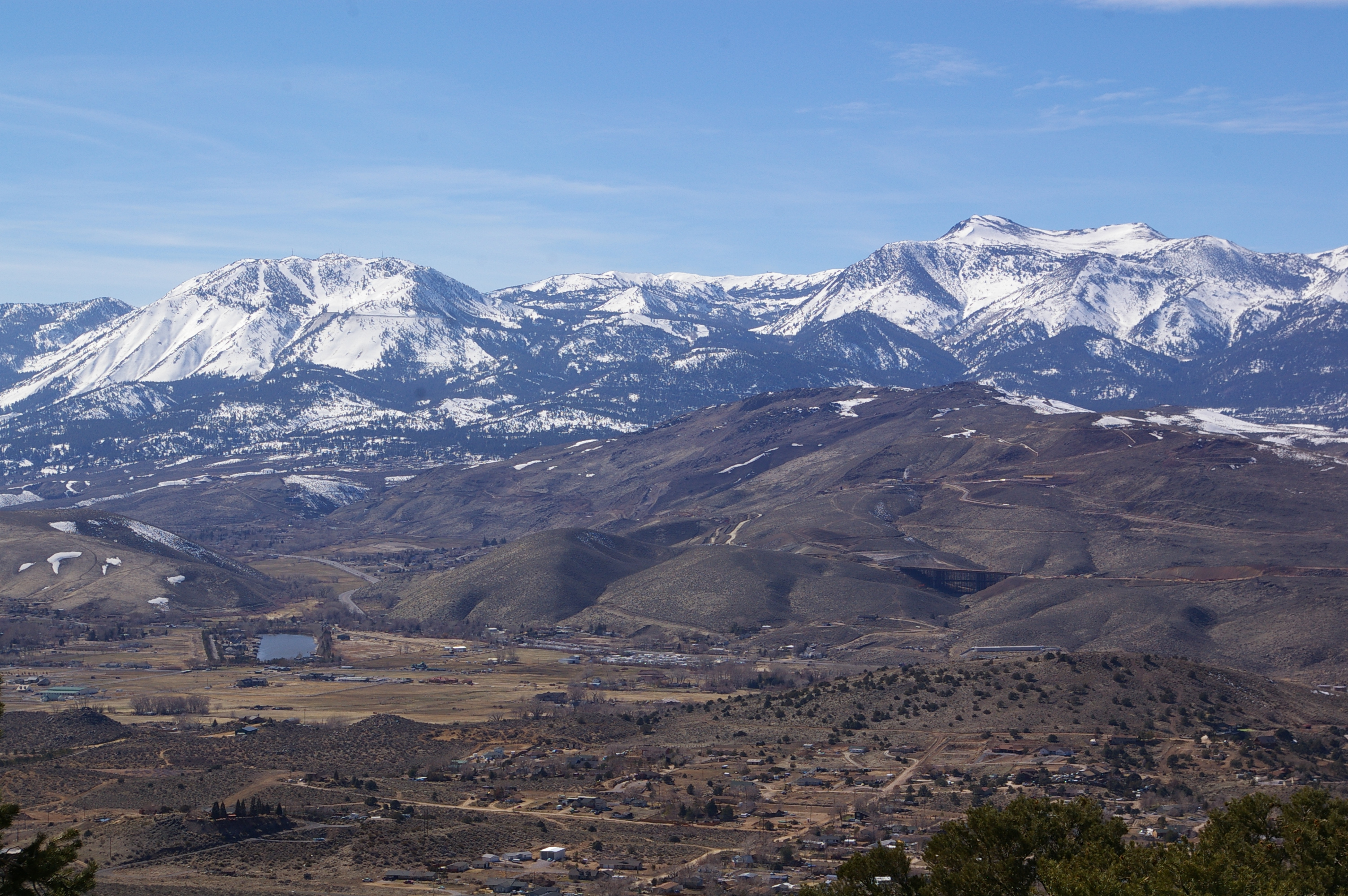
 Current US 395 and future I-580 (under construction) in Pleasant Valley, as seen from Geiger Grade (SR 341)
I-580 is still in development and will eventually be a signed Interstate Highway. The highway exists today (albeit unsigned) from I-80 near Downtown Reno south to Neil Road. The section of the US 395 freeway between Neil Road and Mount Rose Highway (SR 431) is constructed to Interstate specifications, but is not currently part of unsigned I-580. Eventually, the highway will continue in a southerly direction from Neil Road to terminate at the junction of US 395 and US 50 just south of Carson City. I-580 shields are expected to be posted once construction projects on future segments of the highway are complete. At this time, there are no indications that I-580 will be extended north of I-80, even though this portion is also built to Interstate Highway standards.[citation needed]
History
Development of the I-580/US 395 freeway has been in planning since 1957, but significant construction did not occur until over a decade later. Below is a timeline of the opening dates of the current freeway segments that are or will be part of I-580.[2]
- 1964-1970: Washoe Valley - Washoe County/Carson City line to Winters Ranch (near junction SR 429)
- 1973: Reno - Panther Valley (north of Reno) to Glendale Avenue (only the I-80 to Glendale Avenue stretch of this segment is designated I-580.)
- 1980: Reno - Glendale Avenue to South Virginia Street (at Exit 63 half-interchange)
- 1983: Reno - South Virginia Street to South Virginia Street (at Exit 61)
- 1983-1998: Reno - South Virginia Street to Mount Rose Highway
- 2006: Carson City - North Carson Street to East William Street (US 50)
- 2009: Carson City - East William Street (US 50) to Fairview Drive
Future
From US 395's freeway terminus at the Mount Rose Interchange in Reno, I-580 will follow a new alignment west of the current roadway in Pleasant Valley to connect with the existing freeway section in Washoe Valley (west of Washoe Lake). I-580 will then use the completed Carson City Freeway to reach its eventual southern terminus south of Carson City.[citation needed]
The I-580 designation is expected to be posted concurrently with US 395 from I-80 in Reno to the freeway's terminus in Carson City, once all future freeway segments are constructed.[citation needed] This action will bring finally bring the Interstate Highway System to Carson City. Nevada's capital is currently one of only five State capitals to not have an Interstate Highway (the other capitals are Juneau, Alaska, Dover, Delaware, Jefferson City, Missouri, and Pierre, South Dakota).[3]
I-580 Freeway Extension Project
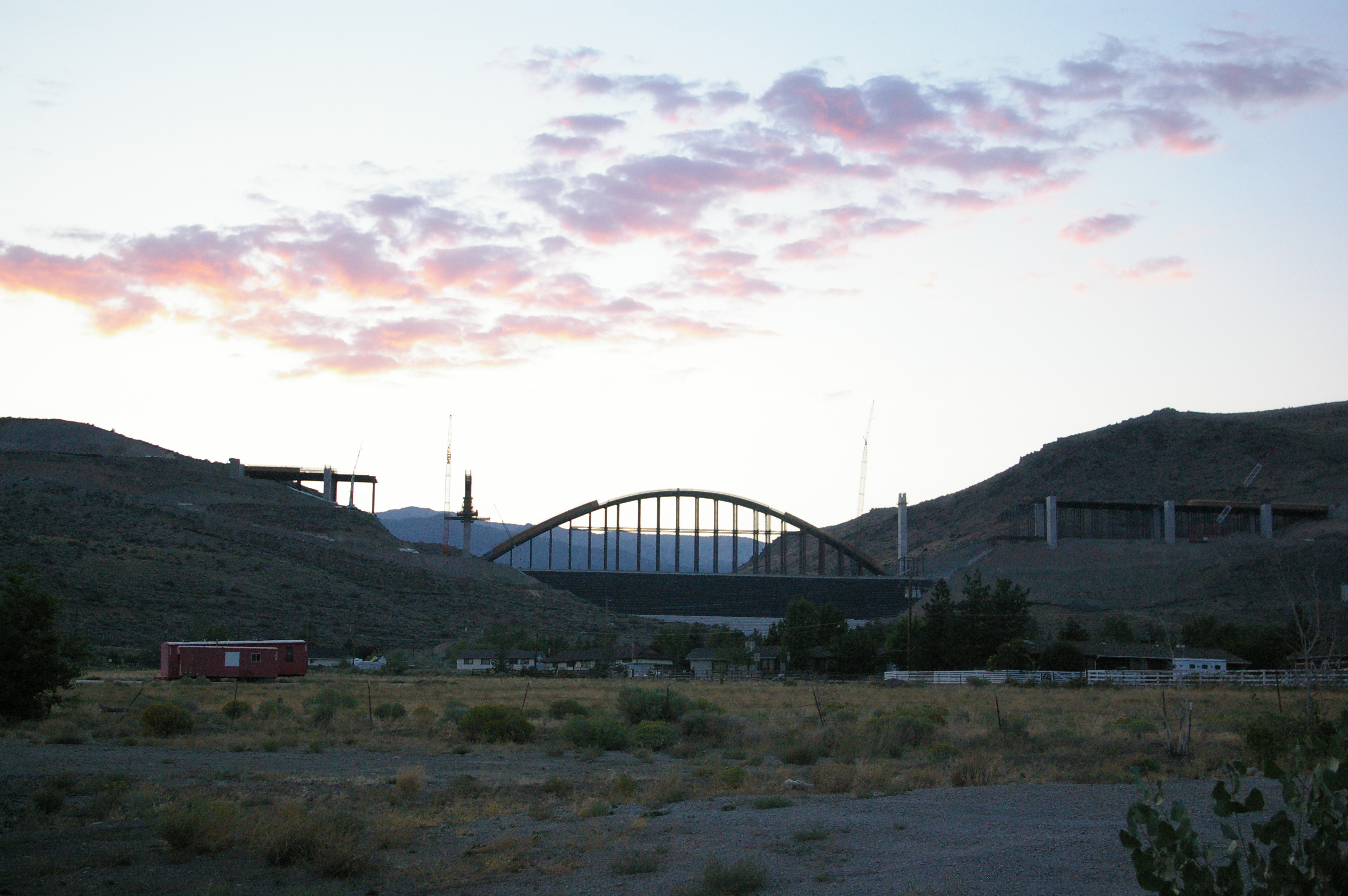
 The Galena Creek Bridge, under construction in Pleasant Valley
North of Washoe Lake (Washoe Valley to Mount Rose Highway), I-580 will be built along the western hillsides of Pleasant Valley. This new highway is designed to remove the Reno/Carson City commuter traffic and Reno/South Lake Tahoe traffic from the routing of US 395 (also SR 430) through Pleasant Valley. Currently, high traffic volumes and excessive speeding have been the cause of numerous traffic accidents and fatalities along this stretch of US 395.[citation needed]
The new freeway will be constructed to Interstate standards and include three travel lanes in each direction. The south half of the Mount Rose interchange will be completed, and a new Bower's Mansion Road (SR 429) interchange will be constructed at the junction of SR 429 and SR 430 near Winters Ranch. Additionally, seven bridges will be constructed to carry the highway over existing streams and roads, the most significant of these being the Galena Creek Bridge. Once constructed, the 1,700-foot (520 m) Galena Creek Bridge with its 690-foot (210 m) span over the creek will be the longest concrete arch bridge in the United States.[4] Construction is currently scheduled to wrap up on the project in 2011, although the new contractor on the project aims to finish the job six months ahead of schedule.
Carson City Freeway
The Carson City Freeway is designed to remove through traffic from the streets of downtown Carson City, especially those using Carson Street (State Route 529) as the connection between Reno and Lake Tahoe. The freeway will bypass downtown to the east, and connect to the junction of US 50 and US 395 south of the city (this is the eventual southern terminus of I-580). The freeway will be constructed to Interstate standards with two lanes in each direction and soundwalls in multiple locations.[5]
The Carson City Freeway is being built in two phases. The first phase constructed the northern half of the freeway from the Eastlake Boulevard interchange (in Washoe Valley) to US 50 east of downtown Carson City. This section was opened to traffic on February 16, 2006.[6] US 395 was rerouted to the freeway (along with a temporary US 50 concurrency on William Street), with old US 395 along North Carson Street being redesignated U.S. Route 395 Business.[7]
Phase two of the project has two parts. Phase 2A constructed the central portion of the Carson City Freeway starting at US 50 and continuing south to the next interchange at Fairview Drive. A partial interchange was constructed at this location in the interim. Phase 2B will complete the remaining freeway to US 50 West, including the interchange with US 395 and South Carson Street. Construction of Phase 2A finished in September 2009;[8] however, construction of Phase 2B may not be completed until as late as 2014 due to funding issues.[5]
Exit list
The current routing of I-580 as recognized by the Nevada Department of Transportation lies entirely within the city of Reno in Washoe County. Mileposts are assigned based upon the distance to the Washoe County/Carson City line, following the proposed routing of the I-580 Extension. Exits are numbered using cumulative mileage along US 395 from the California/Nevada border near Topaz Lake.
- Note: For other exits on US 395, see U.S. Route 395 in Nevada.
Mile[9][original research?] # Destinations Notes 20.85 62 Neil Road South end of I-580 21.63 63 South Virginia Street (US 395 Bus.), Kietzke Lane Southbound exit and northbound entrance 22.69 64 Moana Lane Serves Reno-Sparks Convention Center 23.61 65  Plumb Lane (SR 653), Villanova Drive – Reno-Tahoe International Airport
Signed as exits 65A (Villanova Drive, Plumb Lane) and 65B (airport) southbound 24.59 66 Mill Street 25.12 67 Glendale Avenue (SR 648) 25.85 68 I-80 – Elko, SacramentoNorth end of I-580 1.000 mi = 1.609 km; 1.000 km = 0.621 mi References
- ^ a b Nevada Department of Transportation (January 2008). "Nevada State Maintained Highways: Descriptions, Index and Maps". http://www.nevadadot.com/reports_pubs/State_Maintained/. Retrieved 2008-09-11.
- ^ "History & Overview". I-580 Extension Project website. Nevada Department of Transportation. http://www.freewayextension.com/. Retrieved 2008-09-11.
- ^ "Miscellaneous Interstate System Facts". FHWA Route Log and Finder List. Federal Highway Administration. November 2002. http://www.fhwa.dot.gov/reports/routefinder/. Retrieved 2008-09-11.
- ^ "What's New". I-580 Extension Project website. Nevada Department of Transportation. http://www.freewayextension.com. Retrieved 2008-09-11.
- ^ a b "Overview". Carson City Freeway project website. Nevada Department of Transportation. http://www.ccfreeway.com/Project_Information/Overview/overview.html. Retrieved 2008-09-11.
- ^ Hoover, Sandi (2006-02-17). "After 15 years of waiting, Carson City gets freeway". Reno Gazette-Journal. http://news.rgj.com/apps/pbcs.dll/article?AID=/20060217/NEWS10/602170408/1016/NEWS.
- ^ Anderson, Tim; Jacobs, David (2006-02-10). "Freeway opening spurs hopes of gridlock relief". Reno Gazette-Journal. http://news.rgj.com/apps/pbcs.dll/article?AID=/20060210/NEWS15/602100416/1010/NEWS07.
- ^ Norton, F.T. (2009-09-24). "New bypass opens today". Nevada Appeal. http://www.nevadaappeal.com/article/20090924/NEWS/909239944&parentprofile=search. Retrieved 2010-01-30.
- ^ Milepost as signed along the highway.
External links
Auxiliary routes of Interstate 80 California: 180 (former) • 280 • 380 • 480 (former) • 580 • 680 • 780 • 880 • 880 (former) • 980 — Nevada: 580 (unsigned) — Wyoming: 180 — Nebraska: 180 • 280 (former) • 480 • 580 (former) • 680 — Iowa: 280 • 380 • 480 • 680 — Illinois: 180 • 280 — Ohio: 280 • 480 • 680 — Pennsylvania: 180 • 180 (former) • 280 (former) • 380 • 480 (former) • 680 (former) — New Jersey: 280 • 680 (former)
Interstate Highways in Nevada Current Unsigned 580Categories:- Three-digit Interstate Highways
- Interstate Highways in Nevada
- Interstate 80
- Unsigned auxiliary Interstate Highways


Wikimedia Foundation. 2010.