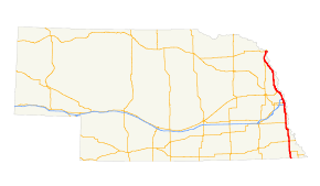
- U.S. Route 75 in Nebraska
-
This article is about the section of U.S. Route 75 in Nebraska. For the entire length of the highway, see U.S. Route 75.
U.S. Highway 75
Route information Maintained by NDOR Length: 187.48 mi[1] (301.72 km) Existed: 1926 – present Major junctions South end:  US-75 at Kansas state line
 US-73 near Dawson
 US-136 in Auburn
 N-2 in Nebraska City
 US-34 between Union and Plattsmouth


 US-275 / I-80 / I-480 / I-680 in Omaha
 US-30 in Blair
 US-77 between Winnebago and South Sioux City

 I-129 / US-20 in South Sioux City
North end: 

 I-129 / US 20 / US 75 at the Iowa state line
Highway system United States Numbered Highways
List • Bannered • Divided • Replaced←  N-74
N-74I-76  →
→In the U.S. State of Nebraska, U.S. Highway 75 is a highway which goes from the Kansas border south of Dawson in the south to the Iowa border in the north at South Sioux City. Portions of the highway are freeway within the Omaha metropolitan area, including an overlap with Interstate 480. Another segment is freeway in the South Sioux City area, an overlap with Interstate 129. Much of the highway parallels the Missouri River.
Contents
Route description
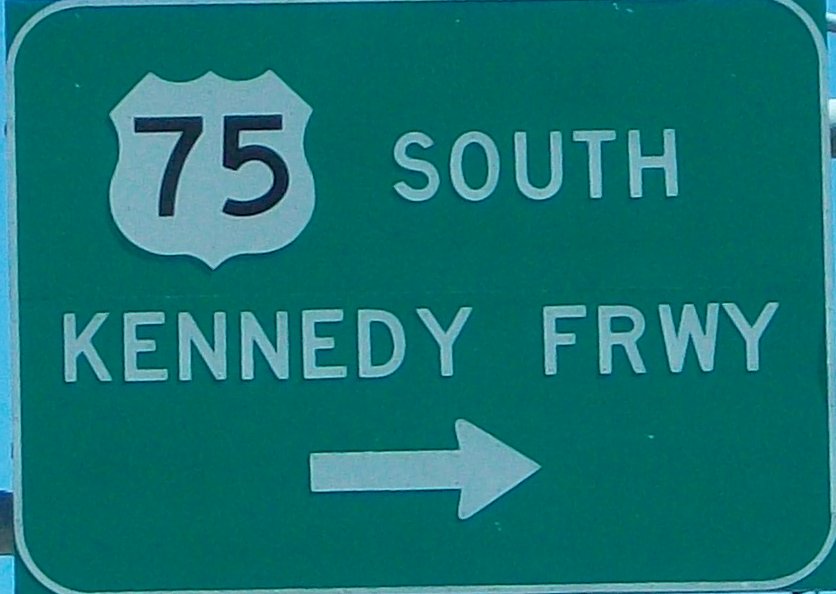
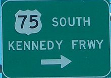 Kennedy Freeway sign in Omaha
U.S. Highway 75 begins at the Kansas border in Richardson County. It intersects Nebraska Highway 8 and then passes through Dawson. North of Dawson, it intersects U.S. Highway 73, Nebraska Highway 4, and Nebraska Highway 62. It continues north into Auburn, where it intersects U.S. Highway 136. It then overlaps Nebraska Highway 67 and intersects Nebraska Highway 128, where the highway becomes a divided highway. It continues as a divided highway until it intersects Nebraska Highway 2 in Nebraska City. It turns west with Nebraska Highway 2 and then turns north at the west end of Nebraska City. It intersects U.S. Highway 34 near Union. The two highways then intersect Nebraska Highway 1 near Murray before the overlap ends in Plattsmouth at their intersection with Nebraska Highway 66. Just north of Plattsmouth, the highway becomes divided again and crosses the Platte River.[1][2]
After crossing the Platte River, U.S. Highway 75 becomes the Kennedy Freeway at its interchange with Fort Crook Road and Fairview Road. It then enters Bellevue, and has four interchanges in Bellevue, including one with Nebraska Highway 370. U.S. Highway 75 then enters Omaha in the South Omaha neighborhood. It then has three interchanges, including one with U.S. Highway 275 and Nebraska Highway 92, before intersecting Interstate 80 and beginning a new overlap with Interstate 480. The overlap continues north until they separate near downtown Omaha. U.S. Highway 75 then continues north on the North Freeway as it passes through North Omaha. The freeway then ends and the highway curves towards North 30th Street. It follows North 30th Street through the Florence neighborhood before turning west. It continues west until intersecting Nebraska Highway 36 and turning north. It then immediately intersects Interstate 680.[1][2]
The highway continues north through Nashville and Fort Calhoun before entering Blair. In Blair, it intersects U.S. Highway 30 and overlaps in Blair. The overlap ends when they intersect Nebraska Highway 91, when U.S. Highway 75 turns north. It goes northwesterly through Herman, then turns north to Tekamah, where it intersects Nebraska Highway 32. It continues north to Decatur, where there is a short overlap with Nebraska Highway 51. It then turns northwest to enter the Omaha Indian Reservation. It then passes through Macy and intersects Nebraska Highway 94 before entering the Winnebago Indian Reservation. U.S. Highway 75 then intersects U.S. Highway 77 before entering Winnebago and leaving the Winnebago Indian Reservation. The two highways continue north through Homer, then turn northeast until at Dakota City, they intersect Nebraska Highway 35. They continue north until the intersection with U.S. Highway 20 and Interstate 129 at South Sioux City. U.S. Highway 75 then overlap U.S. 20 and I-129 eastward until crossing the Missouri River and entering Iowa.[1][2]
History
In 1926, when the highway was created, U.S. Highway 75 went north from Kansas to Omaha, then turned east and crossed the Missouri River to enter Council Bluffs, Iowa. In 1985, U.S. 75 was rerouted to go west of the river between Omaha and Sioux City, Iowa, and U.S. 75 took over the former route of U.S. 73.[3]
Construction of the North Omaha Freeway, coupled with social unrest in the 1970s, greatly changed the North Omaha area. One neighborhood experienced a 30 percent housing loss and major increase in crime.[4] Interstate 580 (abbreviated I-580) was the original designation for this 4-mile (6.4 km) portion of US-75 during the late 1970s and early 1980s. This designation was revoked when the state of Nebraska declined to upgrade the interchange with I-480 to Interstate Highway standards, and the freeway is now solely US-75.
In 2005, the Nebraska Department of Roads began a project to bring the I-480/US-75 interchange up to Interstate standards. Construction was expected to be complete in 2009, but it has been delayed to 2011 due to shortage of funding.[5]
Major intersections
County Location Mile[1] Junction Notes Richardson 0.00 US-75 southKansas border 4.46  N-8
N-8Dawson 10.55 US-73 south12.71  N-4 west
16.71  N-62 east
Nemaha Auburn 27.77 US-136 (Central Avenue)32.78  N-67 south
South end of NE 67 overlap 33.78 N-67 northNorth end of NE 67 overlap Julian 37.19 S-64A west (Main Street) Otoe 42.22  N-128 west (N Road)
Nebraska City 46.19 N-2 eastSouth end of NE 2 overlap 48.27 N-2 westNorth end of NE 2 overlap Cass Union 58.85 US-34 west (South 66th Street)South end of US 34 overlap Murray 65.89  N-1 west
Plattsmouth 71.92  US-34 east / N-66 west
North end of US 34 overlap Sarpy Bellevue 78.97 South end of freeway section Fort Crook Road, Fairview Road Northbound exit and southbound entrance 80.17 Capehart Road, Offutt Air Force Base 81.72  N-370 – Bellevue, Papillion
83.03 Cornhusker Road 84.75 Chandler Road, Fort Crook Road Douglas Omaha 86.42 Q Street 86.90  US-275 / N-92 (L Street)
87.46 F Street 87.94 I-80 – Lincoln, Council Bluffs, Des MoinesI-80 exit 453 87.97 I-480South end of I-480 overlap 88.86 Martha Street Former Nebraska Highway 38, I-480 exit 1A 89.78 Leavenworth Street Northbound exit and southbound entrance, I-480 exit 1B 89.86 Harney Street, Dodge Street To  US-6, Northbound exit and southbound entrance, I-480 exit 2A
90.22 30th Street, Dodge Street To US-6, No northbound exit, I-480 exit 2B90.27 I-480 east – Downtown OmahaNorth end of I-480 overlap, I-480 exit 2C 90.84  N-64 west (Cuming Street)
Northbound exit and southbound entrance 91.15 Hamilton Street 91.82 Lake Street 93.07 Ames Avenue Northbound exit and southbound entrance 93.33 Storz Expressway, Florence Boulevard, Eppley Airfield 93.48 North end of freeway section 96.22 L-28H north (North 31st Street) 97.19  N-36 west (McKinley Street)
97.40-97.42 I-680I-680 exit 12 Washington Blair 114.74 US-30 east (Washington Street)South end of US 30 overlap 115.22  US-30 west (South 19th Street) / N-91 west (Washington Street)
North end of US 30 overlap Burt Tekamah 132.56  N-32 west (L Street)
Decatur 148.41  N-51 west (County Road W51)
South end of NE 51 overlap 148.91 N-51 east (7th Street)North end of NE 51 overlap Thurston Macy 161.17  N-94 west
Winnebago 168.73 US-77 southSouth end of US 77 overlap Dakota Dakota City 182.33  N-35 west
South Sioux City 184.67 South end of freeway section I-129 / US-20 westI-129 exit 1A, west end of I-129/US 20 overlap US-77 north – Sioux CityNorth end of US 77 overlap 185.45 South Sioux City, Dakota City I-129 exit 2 187.48 I-129 / US 20 east / US 75 northIowa border at Sergeant Floyd Memorial Bridge over Missouri River Bannered Routes
- U.S. Route 75 Business in Nebraska City, Nebraska
See also
- U.S. Route 75
- Interstate 129
- Interstate 480 (Nebraska)
References
- ^ a b c d e Nebraska Highway Reference Log Book
- ^ a b c Google, Inc. Google Maps – overview of U.S. Route 75 in Nebraska (Map). Cartography by Google, Inc. http://maps.google.com/maps?f=d&source=s_d&saddr=40,+-95.79813&daddr=41.43949,-96.01853+to:42.44652,+-96.38045&geocode=FQBaYgIdjjxK-g%3BFQJReAIdnt9G-ikb2BrHhZWThzFuSaV31W-aGQ%3BFbiuhwId3llB-g&hl=en&mra=ls&via=1&sll=42.396587,-96.330185&sspn=0.231231,0.676346&ie=UTF8&t=h&z=7. Retrieved 2010-11-12.
- ^ Nebraska Highways 61 to 100
- ^ (2001) State's top community development projects honored. Nebraska Department of Economic Development. Retrieved 4/7/07.
- ^ Nebraska Department of Roads. "US 75 / I-480 Interchange Project". http://www.nebraskatransportation.org/projects/480-75/index.htm. Retrieved March 7, 2010.
U.S. Route 75Previous state:
KansasNebraska Next state:
IowaAuxiliary routes of Interstate 80 California: 180 (former) • 280 • 380 • 480 (former) • 580 • 680 • 780 • 880 • 880 (former) • 980 — Nevada: 580 (unsigned) — Wyoming: 180 — Nebraska: 180 • 280 (former) • 480 • 580 (former) • 680 — Iowa: 280 • 380 • 480 • 680 — Illinois: 180 • 280 — Ohio: 280 • 480 • 680 — Pennsylvania: 180 • 180 (former) • 280 (former) • 380 • 480 (former) • 680 (former) — New Jersey: 280 • 680 (former)
Transportation in Omaha Interstate Highways Freeways Other state routes Airports Public Transit Waterways Other Trails in Omaha · Automobile RowRelated templates: Boulevards • Railroads • Bridges • Streetcars • Streets • ExpresswaysExpressways in Omaha Interstate Highways Freeways Kennedy Freeway · North FreewayOther routes Related templates: Transportation • Boulevards • Railroads • Bridges • Streetcars • StreetsCategories:- Expressways in the Omaha area
- Transportation in Omaha, Nebraska
- U.S. Highways in Nebraska
- U.S. Route 75


Wikimedia Foundation. 2010.