- Interstate 480 (Ohio)
-
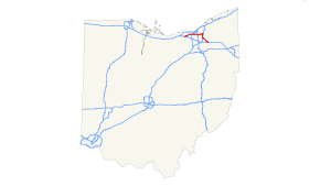
Interstate 480
Route information Maintained by Ohio DOT Length: 41.77 mi[1] (67.22 km) Major junctions West end: 
 I-80 / Ohio Tpk. in North Ridgeville
 I-71 in Brook Park
 I-77 in Independence
 I-271 in Bedford Heights
East end:  I-80 / Ohio Tpk. / SR 14 in Streetsboro
Highway system Auxiliary route of the Interstate Highway System
Main • Auxiliary • BusinessOhio highways
Interstates • U.S. Routes • State Routes←  I-475
I-475I-490  →
→Interstate 480 (I-480) is a loop highway that connects the Ohio Turnpike (I-80) with suburban Cleveland, Ohio. The highway is officially designated the Outerbelt South Freeway, but it is rarely referred to by that name.
The western terminus is at I-80 in North Ridgeville while the eastern terminus is at I-80 in Streetsboro. The width varies from four to ten lanes wide. The entire length of I-480 is 41.77 miles (67.22 km). I-480 provides access to Cleveland Hopkins International Airport via Ohio State Route 237.
Contents
Route description
The freeway is concurrent with I-271 for two miles. I-271 and I-480 are the only two three-digit interstates in the nation that run concurrently with each other for any distance. They run concurrent near Bedford Heights in Cuyahoga County. In Greensboro, North Carolina, future I-785 will run concurrently with I-840.[citation needed]
In 1998, the Governor of Ohio, George Voinovich, gave I-480 the additional name of the "Senator John Glenn Highway", in honor of the former NASA astronaut and a U.S. Senator from Ohio for 24 years.[2]
The Valley View Bridge, which is 212 feet (65 m) high and spans 4,150 feet (1,260 m),[3] carries I-480 across the Cuyahoga River valley.
The portion of freeway connecting I-480 to I-271 and US 422 is called Interstate 480N, an Ohio Department of Transportation designation.[4]
Parts of I-480 were to have been I-271 and/or Interstate 80N.[5]
Exit list
County Location Mile Exit Destinations Notes Lorain North Ridgeville 0.00 I-80 west / Ohio Tpk. west – ToledoWestbound exit and eastbound entrance 0.90 Ohio Turnpike Toll Plaza 1.16 1 
 SR 10 west to US 20 – Oberlin, Norwalk
West end of SR 10 concurrency; westbound left exit and eastbound entrance; continuation beyond I-80 2.03 2 SR 10 east (Lorain Road) to I-80 east / Ohio Tpk. eastEast end of SR 10 concurrency Cuyahoga North Olmsted 3.67 3 Stearns Road 6.15 6  SR 252 (Great Northern Boulevard) – North Olmsted, Olmsted Falls
Signed as exits 6A (south) and 6B (north) westbound 7.57 7 Clague Road – Westlake, Fairview Park Westbound exit and eastbound entrance Cleveland 9.44 9  SR 17 (Brookpark Road) / Grayton Road – Airport
10.17 11 I-71 (via Berea Freeway) – Cleveland, ColumbusEastbound exit and westbound entrance 10.17 10  SR 237 south (Berea Freeway) – Berea, Airport
Eastbound exit is via exit 9 10.71 11 I-71 south – ColumbusEastbound exit is via exit 11 11.60 12A West 150th Street – Brook Park Westbound exit and eastbound entrance 12.71 12B West 130th Street, West 150th Street – Brook Park Signed as exit 12 eastbound Brooklyn 13.79 13 Tiedeman Road – Brooklyn 15.21 15  Ridge Road to US 42
Brooklyn Heights 16.49 16  SR 94 (State Road)
17.76 17A  SR 176 (Jennings Freeway) – Cleveland
Signed as exit 17 eastbound 18.03 17B SR 17 (Brookpark Road) to SR 176 southWestbound exit and eastbound entrance Independence 20.05 20 I-77 – Akron, ClevelandSigned as exits 20A (south) and 20B (north); also provides access to Rockside Road Garfield Heights 21.72 21 Transportation Boulevard, East 98th Street 22.92 22 SR 17 east (Granger Road)Eastbound exit and westbound entrance 23.85 23 SR 14 (Broadway Avenue) – Garfield HeightsCleveland 24.58 24 Lee Road – Maple Heights Westbound exit and eastbound entrance Warrensville Heights 26.03 25 Warrensville Road Eastbound exit and westbound entrance; signed as exits 25A (south) and 25B (north) 26.31 26  US 422 east (via I-480N east) to I-271 north – Warren, Erie
Eastbound exit and westbound entrance Bedford Heights 26.55 25C 
 SR 8 / SR 43 (Northfield Road)
27.94 26A Rockside Road Westbound exit and eastbound entrance 28.02 I-271 north – ErieWest end of I-271 concurrency; westbound exit and eastbound entrance Oakwood 30.99 23 SR 14 west (Broadway Avenue) / Forbes RoadWest end of SR 14 concurrency 32.06 I-271 south – Akron, ColumbusEast end of I-271 concurrency; eastbound exit and westbound entrance Summit Twinsburg 36.30 36  SR 82 – Aurora, Macedonia, Twinsburg
36.99 37  SR 91 – Twinsburg, Hudson, Solon
Portage Streetsboro 41.63 41 Frost Road 42.45 42 I-80 / Ohio Tpk. – Youngstown, Toledo
SR 14 east – RavennaFreeway ends; SR 14 is the road continuation beyond I-80 / Ohio Tpk. 1.000 mi = 1.609 km; 1.000 km = 0.621 mi
Concurrency terminus • Closed/Former • Incomplete access • UnopenedReferences
- ^ Route Log- Auxiliary Routes of the Eisenhower National System of Interstate and Defense Highways - Table 2
- ^ McIntyre, Michael K. (1998-09-22). "I-480 is renamed in honor of Glenn". The Plain Dealer. http://infoweb.newsbank.com/iw-search/we/InfoWeb?p_action=doc&p_topdoc=1&p_docnum=1&p_sort=YMD_date:D&p_product=NewsBank&p_text_direct-0=document_id=(%200F80D08D270B8ED6%20)&p_docid=0F80D08D270B8ED6&p_theme=aggdocs&p_queryname=0F80D08D270B8ED6&f_openurl=yes&p_nbid=D4FL47JCMTI3MTEyNDUxNi4yOTg5MzI6MToxMjoxOTguMzAuMjI4LjA&&p_multi=CPDB. Retrieved 2010-04-12.
- ^ Interstate 480
- ^ Ohio Department of Transportation Technical Services Straight Line Diagram for I-480N
- ^ Ohio Department of Highways (via Roadfan.com). "1957-1958 Biennial Report excerpt". http://www.roadfan.com/clevmap.html. Retrieved 2008-04-02.
External links
Auxiliary routes of Interstate 80 California: 180 (former) • 280 • 380 • 480 (former) • 580 • 680 • 780 • 880 • 880 (former) • 980 — Nevada: 580 (unsigned) — Wyoming: 180 — Nebraska: 180 • 280 (former) • 480 • 580 (former) • 680 — Iowa: 280 • 380 • 480 • 680 — Illinois: 180 • 280 — Ohio: 280 • 480 • 680 — Pennsylvania: 180 • 180 (former) • 280 (former) • 380 • 480 (former) • 680 (former) — New Jersey: 280 • 680 (former) Categories:
- Three-digit Interstate Highways
- Interstate Highways in Ohio
- Interstate 80
- Cleveland area expressways


Wikimedia Foundation. 2010.