- Interstate 470 (Ohio
-
Interstate 470
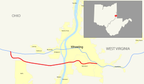
Map of the Wheeling area with I-470 highlighted in redRoute information Auxiliary route of I-70 Maintained by ODOT and WVDOH Length: 10.63 mi[1] (17.11 km)
6.69 mi (10.77 km) in Ohio
3.94 mi (6.34 km) in W. Va.Existed: 1976 – present Major junctions West end:  I-70 near Blaine, Ohio
 US 250 in Wheeling, W. Va.
East end:  I-70 in Wheeling
Location States: Ohio, West Virginia Counties: OH: Belmont WV: Ohio Highway system Ohio highways
Interstates • U.S. Routes • State Routes
West Virginia Routes
State • CountyAuxiliary route of the Interstate Highway System
Main • Auxiliary • Business←  SR 450
OH I-471  →
→←  US 460
WV WV 480  →
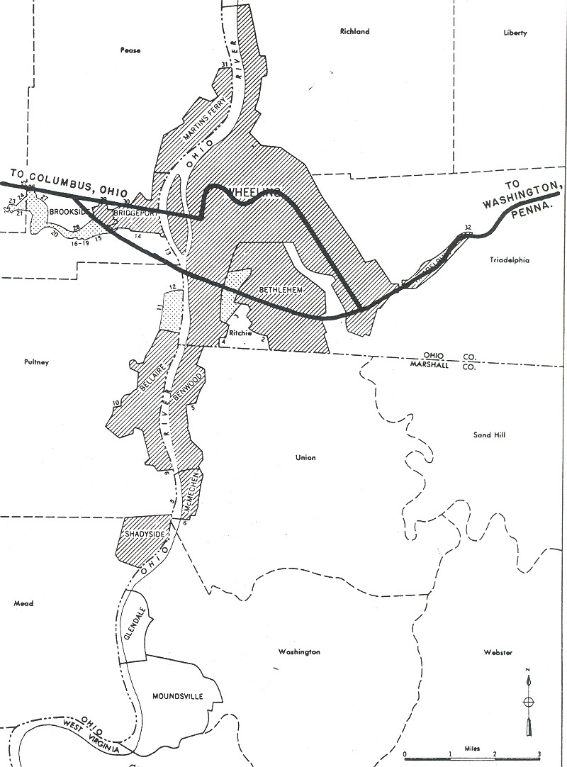
→Interstate 470 (I-470) is a 10.63-mile (17.11 km) long loop of Interstate 70 bypassing the city of Wheeling, West Virginia. The western terminus of the freeway is at an interchange with I-70 near Blaine, Ohio. Traveling southeast through rural Belmont County, the highway approaches the Vietnam Veterans Memorial Bridge carrying I-470 over the Ohio River. After crossing the river into Ohio County, West Virginia, the highway turns northeast, towards the Wheeling neighborhood of Elm Grove and its eastern terminus at I-70 near Wheeling Park.
Construction began in 1975 in the two states but due to a chronic lack of funding, construction in Ohio was stalled between 1976 and 1981. By 1983, both states had completed construction on the freeway. The three-level diamond interchange with concurrent highways U.S. Route 250 (US 250) and West Virginia Route 2 (WV 2) on the eastern banks of the Ohio River was thought to be the most complex interchange in West Virginia's Interstate Highway System at the time of construction. On average, between 26,000 and 38,000 vehicles use the highway daily. During the reconstruction work on the Wheeling Tunnel, I-470 was one of two suggested detour routes to avoid the closed tunnel.
Contents
Route description
The freeway begins at a trumpet interchange with I-70 near the unincorporated community of Blaine, in eastern Belmont County, Ohio. An exit for County Road 28 (CR 28), the penultimate exit for westbound travelers, provides travelers access to US 40 (also known as the National Road). The highway curves to the southeast through the woodlands forming part of the northeastern corner of Neffs, and briefly parallels High Ridge Road (CR 214) before meeting it at a diamond interchange. High Ridge Road to the north connects back to I-70, and to the south links Bellaire to the loop. I-470 continues east into a valley before a trumpet interchange with State Route 7 (SR 7) along the western shores of the Ohio River. The Vietnam Veterans Memorial Bridge carries I-470 over three rail lines and the Ohio River (the state line between Ohio and West Virginia).[2] The rail lines on the western banks of the river belong to the Norfolk Southern Railway and the Wheeling and Lake Erie Railway.[3]
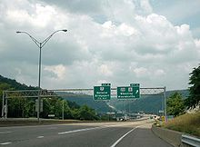 I-470 westbound at the US 250/WV 2 three-level diamond interchange.
I-470 enters Wheeling and Ohio County, West Virginia; the Greater Wheeling Trail, a rail trail, passes underneath the freeway as I-470 approaches a three-level diamond interchange with US 250 and WV 2. The concurrent highways connect to downtown Wheeling in the north and Benwood to the south before the freeway enters another valley and more woodlands. An interchange with West Bethlehem Boulevard provides access to the town of the same name to the south, before the freeway terminates at an incomplete interchange with I-70 over Wheeling Creek near Wheeling Park. Traffic from I-470 can only access eastbound I-70, and only traffic traveling westbound on I-70 can access I-470. The eastern branch of the Greater Wheeling Trail passes underneath the freeway as it passes over the creek.[2]
I-470 is the only auxiliary Interstate Highway in West Virginia.[1] The Ohio and West Virginia Departments of Transportation (ODOT and WVDOT) conduct surveys on their highways to measure traffic volume. This is expressed in terms of average annual daily traffic (AADT), which is a measure of average traffic volume for any day of the year. In 2008, they calculated that as few as 26,350 vehicles traveled along the highway at the western terminus in Ohio, and as many as 38,000 vehicles used I-470 across the Vietnam Veterans Memorial Bridge.[4][5] As part of the Interstate Highway System,[6] the entire route is listed on the National Highway System – a system of roads that are important to the nation's economy, defense and mobility.[7][8]
History
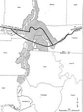 1955 map showing the planned routing of interstate highways through Wheeling
Plans for a southern bypass of Wheeling were first published in 1955 in a document titled General Location of National System of Interstate Highways Including All Additional Routes at Urban Areas.[9] Ohio had completed the stretch of highway between I-70 to just before the SR 7 interchange by 1976;[10][11] however, due to budget deficiencies work did not resume in Ohio until 1981. Construction of the bridge linking the two portions of highway was scheduled to be completed by 1981, but construction did not begin until that year.[12]
After a 3.3-cent-per-gallon (0.87 cents per liter) fuel tax increase, Ohio was able to begin to fund the project again. Bids for construction work on the remainder of the Ohio portion of the freeway were solicited in 1981, with an estimated construction time frame of 37 months to complete the stretch of Interstate between I-70 and the bridge.[13] The West Virginia portion was under construction by 1976,[14] and was completed by 1983 in both states.[15][16] The three-level diamond interchange on the eastern banks of the Ohio River was thought to be the most complex interchange in West Virginia at the time of construction.[17]
Between September and December 1996, about 1,699 ft (518 m) of roadway in Ohio was closed so the ODOT could stabilize and repave the roadway; the rocks forming the top of an abandoned mine underneath the freeway had become overstressed.[18]
The Wheeling Tunnel was closed for reconstruction work in 2007,[19] 2008[20] and 2010.[21] Travelers who wished to continue through Wheeling were directed to I-470, or through Wheeling along city streets.[20]
Exit list
State County Location Mile[2] Exit Junction Notes Ohio Belmont Pultney Township 0.0 I-70 west – ColumbusWestbound exit and eastbound entrance 1 Banfield Road, Mall Road (CR 28) Westbound exit only; Eastbound entrance is to I-70 before I-470 begins 3.2 3  CR 214 (High Ridge Road)
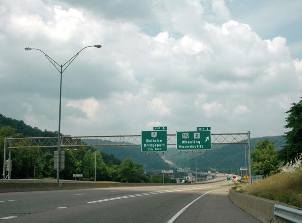
6.3 6  SR 7 – Bellaire, Bridgeport
Ohio River Vietnam Veterans Memorial Bridge Ohio – West Virginia state line West Virginia Ohio Wheeling 7.2 1  US 250 / WV 2 – Wheeling, Moundsville
8.8 2  CR 91/1 – Bethlehem
10.6 I-70 east – Washington, PAEastbound exit and westbound entrance 1.000 mi = 1.609 km; 1.000 km = 0.621 mi
Concurrency terminus • Closed/Former • Incomplete access • UnopenedReferences
- ^ a b "Table 3: Interstate Routes in Each of the 50 States, District of Columbia, and Puerto Rico". FHWA Route Log and Finder List. Federal Highway Administration. October 31, 2002. http://www.fhwa.dot.gov/reports/routefinder/table3.htm. Retrieved January 24, 2011.
- ^ a b c Google, Inc. Google Maps – Interstate 470 (Map). Cartography by Google, Inc. http://maps.google.com/maps?f=d&source=s_d&saddr=I-470+E&daddr=I-470+E&hl=en&geocode=FZNmYwId2V0u-w%3BFaUUYwIdbDMx-w&mra=dme&mrcr=0&mrsp=1&sz=17&sll=40.047485,-80.660902&sspn=0.002973,0.006899&ie=UTF8&ll=40.049168,-80.713463&spn=0.096189,0.220757&z=12. Retrieved January 24, 2011.
- ^ Ohio Department of Transportation (June 2007). 2007–2009 Official Ohio Rail Map (Map). 1 in ≈ 9 mi. Section Q8. http://www2.dot.state.oh.us/map1/OhioRailMap/images/Ohio-Rail-Map-07-09-Fr-Lg.jpg.
- ^ "Traffic Survey Report - Belmont County" (PDF). Ohio Department of Transportation. 2008. p. 5. http://www.odotonline.org/techservapps/traffmonit/TMReports/TSR_Report/County_Reports/2008_Reports/bel08.pdf. Retrieved January 25, 2011.
- ^ West Virginia Department of Transportation (2008) (PDF). I-470: Ohio to I-70 (Map). http://www.transportation.wv.gov/highways/programplanning/preliminary_engineering/traffic_analysis/trafficvolume/interstatecounts/Documents/I470%20OH%20to%20I70-08.pdf. Retrieved January 25, 2011.
- ^ Slater, Rodney E. (Spring 1996). "The National Highway System: A Commitment to America's Future". Public Roads (Federal Highway Administration) 59 (4). ISSN 0033-3735. http://www.fhwa.dot.gov/publications/publicroads/96spring/p96sp2.cfm. Retrieved January 24, 2011.
- ^ Federal Highway Administration (March 2005) (PDF). National Highway System: West Virginia (Map). http://www.fhwa.dot.gov/planning/nhs/maps/wv/wv_WestVirginia.pdf. Retrieved January 23, 2011.
- ^ Federal Highway Administration (March 2005) (PDF). National Highway System: Ohio (Map). http://www.fhwa.dot.gov/planning/nhs/maps/oh/oh_Ohio.pdf. Retrieved January 23, 2011.
- ^ U.S. Bureau of Public Roads (September 1955). General Location of National System of Interstate Highways Including All Additional Routes at Urban Areas (Map). Wheeling, West Virginia inset. http://commons.wikimedia.org/wiki/File:Wheeling,_West_Virginia_1955_Yellow_Book.jpg.
- ^ Ohio Department of Transportation (1975) (MrSID). Official Ohio Highway Map (Map). Section O10. http://www.dot.state.oh.us/Divisions/TransSysDev/Innovation/prod_services/Documents/StateMaps/otm1975a.sid. Retrieved January 25, 2011.
- ^ Ohio Department of Transportation (1976) (MrSID). Official Ohio Highway Map (Map). Section O10. http://www.dot.state.oh.us/Divisions/TransSysDev/Innovation/prod_services/Documents/StateMaps/otm1976a.sid. Retrieved January 25, 2011.
- ^ Robinson, E O'Neil (July 25, 1983). "Wheeling's I-470 is Troubled Bridge". Pittsburgh Post-Gazette. Associated Press. http://news.google.com/newspapers?id=bJ5RAAAAIBAJ&sjid=pG0DAAAAIBAJ&pg=3746,5061217&hl=en. Retrieved January 25, 2011.
- ^ "Machinery Ready to Roll". The Daily Times. Associated Press (Portsmouth, Ohio): p. 11. September 15, 1981. http://news.google.com/newspapers?id=qLhQAAAAIBAJ&sjid=ldAMAAAAIBAJ&pg=3630,1258000&dq=interstate-470+construction+wheeling&hl=en. Retrieved January 25, 2011.
- ^ West Virginia Department of Highways (1976). West Virginia Official Highway Map (Map).
- ^ Ohio Department of Transportation (1983) (MrSID). Official Ohio Highway Map (Map). Section O10. http://www.dot.state.oh.us/Divisions/TransSysDev/Innovation/prod_services/Documents/StateMaps/otm1983a.sid. Retrieved January 25, 2011.
- ^ "West Virginia Highways: Classification Systems, Characteristics and Usage". As a Matter of Fact.... West Virginia Department of Transportation. 1997. pp. II–8. http://www.millenniumhwy.net/wvroads/system.pdf. Retrieved January 25, 2011.
- ^ Hodel, Martha Bryson (November 20, 1980). "New Bridges to Cut Down Travel Time". The Daily Sentinel. Associated Press (Pomeroy, Ohio): p. 1. http://news.google.com/newspapers?id=yCJDAAAAIBAJ&sjid=u6wMAAAAIBAJ&pg=5458,5045166&dq=interstate-470+construction+wheeling&hl=en. Retrieved January 25, 2011.
- ^ Ruegsegger, L. Rick; Lefchik, Thomas E. (July–August 1999). "Managing Car-Crunching Sinkholes". Public Roads (Federal Highway Administration) 63 (1). ISSN 0033-3735. http://www.fhwa.dot.gov/publications/publicroads/99julaug/minehole.cfm. Retrieved February 2, 2011.
- ^ Connors, Fred (October 27, 2007). "Ready or Not, Tunnel to Open". The Intelligencer & Wheeling News Register. Archived from the original on February 4, 2011. http://www.webcitation.org/5wEtr0ZYw. Retrieved January 24, 2011.
- ^ a b "Motorists Warned to Avoid Wheeling Tunnel". WHSV-TV. July 23, 2008. Archived from the original on February 4, 2011. http://www.webcitation.org/5wEu7JoIc. Retrieved January 24, 2011.
- ^ Johnson, Jr., J.W. (February 2, 2010). "Tube Closed Until October". The Intelligencer & Wheeling News Register. Archived from the original on February 4, 2011. http://www.webcitation.org/5wEtu4EIE. Retrieved January 24, 2011.
External links
 Media related to Interstate 470 (Ohio-West Virginia) at Wikimedia Commons
- Interstate 470 at AA Roads
- Interstate 470 (in Ohio) at State Ends
Auxiliary routes of Interstate 70  Categories:
- Interstate 70
- Three-digit Interstate Highways
- Interstate Highways in Ohio
- Interstate Highways in West Virginia
- Transportation in Ohio County, West Virginia
- Transportation in Belmont County, Ohio


Wikimedia Foundation. 2010.