- Interstate 670 (Ohio)
-
Interstate 670
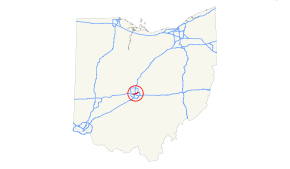
Route information Maintained by ODOT Length: 10.43 mi[1] (16.79 km) Existed: 1975 (by FHWA), 1976 (by ODOT),[citation needed] completed 2003 – present Major junctions West end:  I-70 in Columbus
 I-71 / SR 315 in Columbus
East end: 
 I-270 / US 62 near Gahanna
Highway system Auxiliary route of the Interstate Highway System
Main • Auxiliary • BusinessOhio highways
Interstates • U.S. Routes • State Routes←  SR 669
SR 671  →
→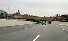 View westbound at High Street
Interstate 670 (I-670) is an Interstate Highway in the U.S. state of Ohio that passes through downtown Columbus, connecting I-70 west of downtown with I-270 and US 62 near the eastern suburb of Gahanna. I-670 provides access to Port Columbus International Airport, and intersects SR 315 and I-71 downtown. The section between SR 315 and I-71 is commonly referred to by locals as the "North Innerbelt", with the rest of the innerbelt consisting of SR 315 (west), I-70 (south), and I-71 (east and south).
Contents
History
In the late 1970s, the Ohio Department of Transportation was unable to complete the Spring-Sandusky interchange, linking both sections of the highway, due to budget shortfalls and environmental regulations, leaving I-670 the only uncompleted Interstate in Ohio. Two decades passed before work began on the last remaining section, bridging the gap between the two completed sections. Work on this section also included the High Street cap, a cut-and-cover bridge over the highway featuring shops and restaurants. I-670 was finally completed in 2003.
Route description
West of I-71, I-670 passes around both sides of Fort Hayes with two two-way roadways. The south roadway carries the eastbound main lanes and the westbound entrance ramps from I-71 north and SR 3 (Cleveland Avenue), while the north roadway carries the westbound main lanes and the eastbound entrance from US 23 north (4th Street) and High Street.
Exit list
The entire route is in Franklin County.
Location Mile[1] # Destinations Notes Columbus 0.00 I-70 west – Dayton, IndianapolisWestbound exit and eastbound entrance. No guide signage exists to inform WB traffic what freeway they are on for several miles beyond the end of I-670. 0.46 1A  US 33 west
Westbound exit and eastbound entrance 0.95 1B Grandview Avenue Signed as exit 1 eastbound 2.24 2A US 33 (Dublin Rd) / SR 315 southEastbound exit and westbound entrance; connection to 315 ramps via traffic signals and (for NB-WB traffic) a short stretch of 33 2.42 2A SR 315 southWestbound exit and eastbound entrance 2.43 2B SR 315 north3.14 3 Goodale Street, Neil Avenue 3.52-
3.954  US 23 (Fourth Street, Third Street) / High Street
Signed as exits 4A (south) and 4B (north) eastbound and 4A (north) and 4B (south) westbound 4.33 4C  SR 3 (Cleveland Avenue) / Leonard Avenue
Westbound exit is part of exit 5 4.58-
4.765  I-71 / US 40 (Broad Street) – Cleveland
Signed as exits 5A (I-71 south), 5B (US 40), and 5C (I-71 north) eastbound (5B was formerly part of 5A, and 5C was 5B[2]); no mention of 40 on WB signage 6.44 6 Leonard Avenue 7.56 7 US 62 west (5th Avenue)West end of US 62 overlap 8.50-
9.069 Johnstown Road, Cassady Avenue, Stelzer Road - Port Columbus International Airport 10.43 I-270 – Cleveland, Wheeling10.43 US 62 east – GahannaContinuation beyond I-270 References
- ^ a b Ohio Department of Transportation, Straight Line Diagrams, January 1, 2007
- ^ roadfan.com: I-670 Signage: includes photos of old and new signs on I-670 east at I-71
Auxiliary routes of Interstate 70  Categories:
- Interstate 70
- Interstate Highways in Ohio
- Three-digit Interstate Highways
- Buildings and structures in Columbus, Ohio


Wikimedia Foundation. 2010.