- Interstate 70 in Ohio
-
This article is about the section of Interstate 70 in Ohio. For the entire length of the highway, see Interstate 70.
Interstate 70
Route information Maintained by Ohio DOT Length: 225.60 mi[1] (363.07 km) Existed: 1956 – present Major junctions West end: 
 I-70 / US 35 at Indiana state line
 I-75 near Vandalia
 I-71 in Columbus
 I-77 near Cambridge
East end:  I-70 at West Virginia state line
Highway system Main route of the Interstate Highway System
Main • Auxiliary • BusinessOhio highways
Interstates • U.S. Routes • State Routes←  US 68
US 68I-71 →In the U.S. state of Ohio, Interstate 70 provides access between Indiana and West Virginia.
Contents
Route description
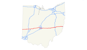
Along its path through Ohio, Interstate 70 passes through the following counties: Preble, Montgomery, Clark, Madison, Franklin, Fairfield, Licking, Muskingum, Guernsey and Belmont County. As an Interstate highway, by default, Interstate 70 is a part of the National Highway System, a network of highways deemed most important for the country's economy, mobility and defense.[2]
History
Interstate 70 appeared on the original AASHTO interstate route numbering map from August 14, 1957. It was envisioned as a modern upgrade of the old National Pike (US-40), the main east–west route through the heart of the state, built closely parallel to, but on a separate alignment as the then overburdened and obsolete highway. The 21-mile (34 km) section between Kirkersville and Gratiot (current Exits 122 - 142), was the first new construction opened to traffic (1959). At that time, the highway was accessed at both ends via temporary at-grade intersections with the old National Pike, with I-70 and US-40 sharing the same carriageways.
Once the road was extended westward towards Columbus by 1968, access was routed to Exit 122, with the western 1-mile (1.6 km) access road continuing US-40 back to the old National Pike becoming part of OH-158 (though the westbound lanes were abandoned). The following year, the highway was opened eastward to Zanesville, with a new interchange, Exit 142, at Gratiot. The at-grade intersection with the old National Pike was subsequently blocked off, to be erased by years of overgrowth. The US-40 designation was returned to the Pike around the same time, replacing the temporary OH-440 designation.
Exit list
County Location Mile[3] # Destinations Notes Preble New Westville 1.66 1 US 35 southEast end of US 35 overlap; eastbound exit and westbound entrance 9.91 10  US 127
Lewisburg 14.66 14  SR 503
Montgomery Arlington, Brookville 21.01 21 Arlington Road – Arlington, Brookville Clayton 24.05 24  SR 49 north (Dayton Greenville Pike) / Brookville Salem Pike
West end of SR 49 overlap 25.88 26 SR 49 south (Salem Avenue) / Hoke RoadEast end of SR 49 overlap Englewood 28.97 29  SR 48 (Main Street)
Vandalia 32.07 32 Dayton International Airport Access Road – Dayton International Airport 2-mile Interstate-grade spur freeway feeding into the airport, with one interchange at US 40 33.87 33 I-75 – Dayton, Cincinnati, ToledoSigned as exits 33A (south) and 33B (north) Huber Heights 36.67 36  SR 202 (Old Troy Pike)
38.64 38  SR 201 (Brandt Pike)
Huber Heights 41.00 41 
 SR 4 west / SR 235
West end of SR 4 overlap; signed as exits 41A (south) and 41B (north) eastbound Clark Fairborn 44.32 44  I-675 / Spangler Road – Cincinnati, Springfield
Signed as exits 44A (south) and 44B (north) eastbound 46.67 47 SR 4 eastEast end of SR 4 overlap; westbound exit is via exit 48 Enon 47.79 48 Enon Road Eastbound exit is via exit 47 Springfield 52.23 52 US 68Signed as exits 52A (south) and 52B (north) 54.47 54  SR 72 (Limestone Street)
59.36 59  SR 41 (Charleston Pike)
62.02 62  US 40 (National Road)
South Vienna 66.33 66  SR 54 (Urbana Street)
Madison Summerford 72.35 72  SR 56
SR 56Lafayette, Gillivan 79.09 79  US 42
US 4280.74 80  SR 29
SR 29West Jefferson 85.38 85  SR 142
Franklin Rome 91 Hilliard Rome Road Signed as exits 91A (south) and 91B (north) westbound Columbus 93  I-270 – Cincinnati, Cleveland
Signed as exits 93A (south) and 93B (north) eastbound 94 Wilson Road 95 Hague Avenue, Fisher Road Westbound exit and eastbound entrance 96  I-670 east – Airport
Eastbound left exit and westbound entrance 97 US 40 (Broad Street)98A 
 US 62 (Central Avenue) / SR 3 / Sullivant Avenue
Signed as exit 98 eastbound; eastbound exit is via exit 97 98B Mound Street Westbound exit and eastbound entrance 99  I-71 south / SR 315 north – Cincinnati
West end of I-71 overlap; signed as exits 99A (south) and 99B (north) 99C US 62 (Town Street) / SR 3 / Rich StreetWestbound exit and eastbound entrance 100A Fullton Street, Front Street, Mound Street Eastbound exit and westbound entrance 100B 
 US 23 (4th Street) / US 33 (Livingston Avenue)
Signed as exit 100 westbound 101A I-71 north – ClevelandEast end of I-71 overlap; signed as exit 101 westbound 101B Mooberry Street Eastbound exit only 102 Mooberry Street, Cole Street 103A US 33 (Livingston Avenue) / Alum Creek DriveSigned as exit 103 westbound; no eastbound entrance 103B Alum Creek Drive Eastbound exit and entrance 105A US 33 (College Avenue)Eastbound exit and westbound entrance 105B James Road Signed as exits 105A (south) and 105B (north) westbound 107  SR 317 (Hamilton Road)
Signed as exits 107A (south) and 107B (north) eastbound 108 I-270 – Cincinnati, ClevelandSigned as exits 108A (south) and 108B (north) westbound Brice 110 Brice Road – Brice Signed as exits 110A (south) and 110B (north) eastbound Fairfield 112  SR 256 (Reynoldsburg Baltimore Road)
Signed as exits 112A (south) and 112B (north) eastbound 112C  SR 204 (Blacklick-Eastern Road)
Eastbound exit only Licking Etna 118  SR 310
Kirkersville 122  SR 158 (Baltimore Road)
Luray 126  SR 37 (Lancaster Road)
Hebron, Buckeye Lake 129  SR 79 (Hebron Road)
Signed as exits 129A (south) and 129B (north) Jacksontown, Edgewater Beach 132  SR 13 (Jacksontown Road)
Brownsville 141  SR 668 (Brownsville Road)
Eastbound exit and westbound entrance Muskingum Gratiot 142 Mt. Perry Road Westbound exit and eastbound entrance 152 US 40 (National Road)West Zanesville 153A Liberty Street, State Street, Blue Street Signed as exit 153 eastbound 153B Maple Avenue Westbound exit and eastbound entrance Zanesville 154 5th Street, 6th Street, Elberon Avenue Eastbound exit and westbound entrance 155 
 SR 60 (Underwood Street) / SR 146
Pleasant Grove 157  SR 93 (Pleasant Grove Road)
160 Sonora Road 164  US 22 / US 40
New Concord 169  SR 83 (Friendship Drive)
Guernsey Fairdale 176.25 176  SR 723 north
178.84 178  SR 209 (Southgate Parkway)
179.89-180.08 180 I-77 – Marietta, Cambridge, ClevelandSigned as exits 180A (south) and 180B (north) Old Washington 186.70 186  US 40 west (National Road) / SR 285 (Wintergreen Road)
West end of US 40 overlap Middlebourne 193.42 193  SR 513 (Batesville Road)
Fairview 198.69 198 CR 114 (Fairview Road) / Old National Road, Fair Avenue, Oxford Road Former US 40 east Belmont Hendrysburg 202.55 202  SR 800 (Hendrysburg Road) / CR 102 (Mt. Olivett Road)
Former US 40 west 204.77 204 US 40 east (National Road) / McMillan RoadEast end of US 40 overlap; eastbound exit and westbound entrance Morristown 208.27 208  SR 149
Great Western 212.92-213.09 213  US 40 (National Road) / SR 331
East Richland, St. Clairsville 215.24 215 US 40 (National Road)St. Clairsville 216.81 216  SR 9
SR 9218.64 218 Mall Road 219.67 219  I-470 east – Wheeling
Eastbound exit and westbound entrance Blaine 220.29 220 US 40 (National Road) / Bellaire High Ridge RoadAetnaville, Bridgeport 225.27 225 Marion Street References
- ^ Route Log- Main Routes of the Eisenhower National System of Interstate and Defense Highways - Table 1
- ^ Federal Highway Administration (December 2003) (PDF). National Highway System: Ohio (Map). http://www.fhwa.dot.gov/planning/nhs/maps/oh/oh_Ohio.pdf. Retrieved 2011-01-24.
- ^ Ohio Department of Transportation. "Technical Services Straight Line Diagrams". http://www.odotonline.org/techservapps/SLD/default.htm. Retrieved 2011-01-25.
Interstate 70Previous state:
IndianaOhio Next state:
West VirginiaCategories:- Interstate 70
- Interstate Highways in Ohio


Wikimedia Foundation. 2010.