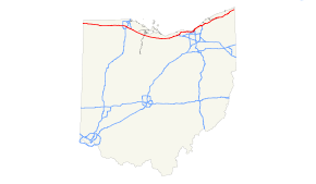
- Interstate 90 in Ohio
-
Interstate 90
Route information Maintained by OTC and Ohio DOT Length: 244.75 mi[1] (393.89 km) Existed: 1956 – present Major junctions West end: 

 I-80 / I-90 / Ind. Toll Rd. at Indiana state line
 I-80 / Ohio Tpk. in Elyria Township

 I-71 / I-490 in Cleveland
 I-77 in Cleveland
 I-271 in Willoughby Hills
 SR 11 near Ashtabula
East end: I-90 at Pennsylvania state lineHighway system Main route of the Interstate Highway System
Main • Auxiliary • BusinessOhio highways
Interstates • U.S. Routes • State Routes←  SR 89
SR 89SR 91  →
→In the U.S. state of Ohio, Interstate 90 runs east–west across the northern tier. Much of it is along the Ohio Turnpike, but sections outside the turnpike pass through Cleveland and northeast into Pennsylvania.
Contents
Route description
 Incomplete I-90 in Cleveland, looking east from 14th St. W, photo taken in July, 1973. Today signed as I-490
In the western half of Ohio, Interstate 90 is jointly signed with the Ohio Turnpike/Interstate 80. Originally, I-90 was planned to be a separate road through Toledo, running parallel to the Ohio Turnpike.[citation needed] Parts of that route were built, and initially labeled State Route 2 until I-90 was complete to Toledo. However, the plan to build a separate road was abandoned, and the Ohio Turnpike–I-90 connector (designated Exit 8A, now Exit 142) was built in Lorain County in Amherst Township and Elyria Township by 1976.[2]
From the exit east, I-90/State Route 2 travels east along the south shore of Lake Erie through Cuyahoga County to downtown Cleveland. State Route 2 separates from Interstate 90 at Detroit Road in Rocky River. Interstate 90 crosses the Cuyahoga River via the Innerbelt Bridge into downtown Cleveland and, after passing Dead Man's Curve, follows the East Shoreway northeastward along the lakeshore toward Euclid, again co-signed with State Route 2. Interstate 90 separates from State Route 2 in Euclid and passes through Lake County and Ashtabula County as it continues to travel northeast towards the Pennsylvania state line in Conneaut.
Naming
The entire free section of I-90 in Ohio is called the "AMVETS Highway".[3]
The section of I-90 that runs through Willoughby Hills is named "Cpl. Joshua Harmon Memorial Highway"[4] in honor of an Army medic that was killed in the Iraq War in August 2007.[5]
In Greater Cleveland, portions of I-90 carry various names, such as the Innerbelt Freeway, the Cleveland Memorial Shoreway, the Lakeland Freeway, and the Euclid Spur.
Exit list
County Location[6][7] Mile[8] Old exit New exit[8] Destinations Notes Indiana–Ohio state line 0.0 I-80 / I-90 / Ind. Toll Rd. continues into IndianaWilliams Northwest Township 2.0 1 —  SR 49
SR 49Diamond interchange with no ramp tolls 2.7 1A 2 Westgate Toll Barrier Jefferson Township 13.5 2 13  SR 15 – Bryan, Montpelier
Fulton Franklin Township 25.5 2A 25  SR 66 – Archbold, Fayette
Opened November 13, 1998[9] Dover Township 34.9 3 34  SR 108 – Wauseon
Pike Township 39.8 3B 39  SR 109 – Delta, Lyons
Opened December 20, 1996[10] Lucas Monclova Township 52.6 3A 52  SR 2 – Swanton, Toledo Airport
Maumee 59.5 4 59 

 US 20 to I-475 / US 23 – Maumee, Toledo
Wood Perrysburg 64.9 4A 64  I-75 – Toledo, Dayton
Lake Township 71.7 5 71 
 I-280 north / SR 420 south – Toledo, Detroit, Stony Ridge
Ottawa Harris Township 81.8 5A 81  SR 51 – Elmore, Elmore, Woodville, Gibsonburg
Opened February 6, 1997[11] Sandusky Sandusky Township 91.6 6 91  SR 53 – Fremont, Port Clinton
Erie Groton Township 110.2 6A 110  SR 4 – Sandusky, Bucyrus
Opened December 15, 1994[12] Milan Township 118.5 7 118  US 250 – Sandusky, Norwalk
Lorain Brownhelm Township 135.9 7A 135 Baumhart Road – Vermilion Opened December 13, 1995[13] Amherst Township 140.6 7B 140  SR 58 – Amherst, Oberlin
Opened November 30, 2004[14] Elyria Township 142.8 8A 142 I-80 west / Ohio Tpk. – ToledoEastbound exit, westbound entrance; eastern end of the I-80/Ohio Tpk. concurrency 144 SR 2 west – Lorain, SanduskyWest end of SR 2 overlap; westbound exit and eastbound entrance Elyria 145  SR 57 to I-80 / Ohio Tpk. – Elyria, Lorain
Signed as exits 145A (south) and 145B (north) Sheffield 148  SR 254 – Sheffield, Avon
Avon 151  SR 611 – Avon, Sheffield
153  SR 83 – Avon Lake, Avon
Nagel Road Proposed[15] Cuyahoga Westlake 156 Crocker Road, Bassett Road 159  SR 252 (Columbia Road)
160 Clague Road Westbound exit and eastbound entrance Rocky River 161 SR 2 east / SR 254 (Detroit Road)East end of SR 2 overlap; eastbound exit and westbound entrance 162 Hilliard Boulevard – Rocky River Westbound exit and eastbound entrance Lakewood 164 McKinley Avenue – Lakewood Cleveland 165A Warren Road Signed as exit 165 eastbound 165B Bunts Road, West 140th Street Eastbound exit is via exit 165 166 West 117th Street 167  To SR 10 (Lorain Avenue) / West Boulevand
Eastbound exit and westbound entrance 167A West 98th Street, West Boulevard Westbound exit and eastbound entrance 167B SR 10 (Lorain Avenue)Westbound exit and eastbound entrance 169 West 44th Street, West 41st Street 170A  US 42 (West 25th Street)
Eastbound exit and westbound entrance 170C I-490 east to I-77Eastbound exit and westbound entrance 170B  I-71 south / SR 176 south – Columbus
171 West 14th Street, Abbey Avenue Westbound exit and eastbound entrance (closed) 171 
 US 422 / SR 14 (Broadway, Ontario Street)
Eastbound exit and westbound entrance (closed); signed at exits 171A (east) and 171B (west) 172A I-77 south / East 9th Street – AkronEast 9th Street access from I-90 eastbound only; I-77 access from I-90 westbound only[16][17] 172B Eastbound exit and westbound entrance 172C Carnegie Avenue Eastbound exit and westbound entrance 173A Prospect Avenue No eastbound exit 173B Chester Avenue US 322 (unsigned) 173C Superior Avenue, St. Clair Avenue US 6 (unsigned) 174A Lakeside Avenue Eastbound exit and westbound entrance 174B SR 2 west – Lakewood, Downtown ClevelandWest end of SR 2 overlap; sharp turn 35 mph (56 km/h) in both directions 175 East 55th Street, Marginal Roads 176 East 72nd Street 177 Martin Luther King Jr. Drive, University Circle Bratenahl 178 Eddy Road – Bratenahl 179  SR 283 east (Lake Shore Boulevard)
Eastbound exit and westbound entrance Cleveland 180 East 140th Street, East 152nd Street Signed as exits 180A (140th Street) and 180B (152nd Street) eastbound 181 East 156th Street Westbound exit and entrance only 182A East 185th Street 182B East 200th Street Euclid 183 East 222nd Street 184  SR 175 (East 260th Street) / Babbitt Road
Signed as exits 184A (Babbitt Road) and 184B (SR 175) eastbound 185 SR 2 east – PainesvilleEast end of SR 2 overlap Cuyahoga–
LakeEuclid–
Wickliffe186 US 20 (Euclid Avenue)Lake Wickliffe 187  SR 84 (Bishop Road)
Willoughby Hills 188 I-271 south – Akron, Columbus189 SR 91 – Willoughby Hills, Willoughby190  I-271 south express / US 422 / SR 87 / Chagrin Boulevard – Columbus
Westbound exit and eastbound entrance Willoughby 193  SR 306 – Mentor, Kirtland
Mentor 195  SR 615 (Center Street) – Kirtland Hills, Mentor
Interchange opened November 24, 2003[18] Concord Township 200  SR 44 – Painesville, Chardon
Leroy Township 205 Vrooman Road Madison 212  SR 528 – Madison, Thompson
Ashtabula Harpersfield Township 218  SR 534 – Geneva
Austinburg Township 223  SR 45 – Ashtabula, Warren
Plymouth Township 228 SR 11 – Youngstown, AshtabulaKingsville Township 235  SR 84 / SR 193 – North Kingsville, Youngstown
Conneaut 241  SR 7 – Andover, Conneaut
Ohio–Pennsylvania state line I-90 continues into Pennsylvania1.000 mi = 1.609 km; 1.000 km = 0.621 mi
Concurrency terminus • Closed/Former • Incomplete access • UnopenedSee also
- Interstate 90 Grand River bridges
References
- ^ Route Log- Main Routes of the Eisenhower National System of Interstate and Defense Highways - Table 1
- ^ Official Transportation Map archive, Ohio Department of Transportation
- ^ Ohio Revised Code 5533.35
- ^ Ohio Revised Code 5533.94
- ^ Albrecht, Brian (2008-09-25). "Stretch of I-90 named for late soldier, Cpl. Joshua Harmon". The Plain Dealer. http://blog.cleveland.com/metro/2008/09/stretch_of_i90_named_for_late.html. Retrieved 2009-02-17.
- ^ Ohio Department of Transportation (2007). Ohio Official Transportation Map (Map). Cartography by ODOT.
- ^ DeLorme (2007). Street Atlas USA (Map).
- ^ a b Staff. "Interchanges". Ohio Turnpike Commission. http://www.ohioturnpike.org/travelers/map/interchanges/. Retrieved August 7, 2011.
- ^ Patch, David (November 10, 1998). "Archbold Turnpike Exit to Open". The Blade (Toledo, OH). http://infoweb.newsbank.com/iw-search/we/InfoWeb?p_action=doc&p_topdoc=1&p_docnum=1&p_sort=YMD_date:D&p_product=NewsBank&p_text_direct-0=document_id=(%200EAF3BC9776F5340%20)&p_docid=0EAF3BC9776F5340&p_theme=aggregated5&p_queryname=0EAF3BC9776F5340&f_openurl=yes&p_nbid=L5FD55NOMTIxMzY2NTE4OC45MDYxMTg6MToxMjoxOTguMzAuMjI4LjA&&p_multi=TOBB. Retrieved June 18, 2008.
- ^ "Fulton County Turnpike Gate to Open Friday". The Blade (Toledo, OH). December 17, 1996. http://infoweb.newsbank.com/iw-search/we/InfoWeb?p_action=doc&p_topdoc=1&p_docnum=1&p_sort=YMD_date:D&p_product=NewsBank&p_text_direct-0=document_id=(%200EAF39F05005505B%20)&p_docid=0EAF39F05005505B&p_theme=aggregated5&p_queryname=0EAF39F05005505B&f_openurl=yes&p_nbid=Q67S5DIWMTIxMzY2NDY1Mi40ODk0Nzg6MToxMjoxOTguMzAuMjI4LjA&&p_multi=TOBB. Retrieved June 16, 2008.
- ^ Patch, David (February 7, 1997). "Turnpike's Gate 5A Opens, Widens Elmore Area Access". The Blade (Toledo, OH). http://infoweb.newsbank.com/iw-search/we/InfoWeb?p_action=doc&p_topdoc=1&p_docnum=1&p_sort=YMD_date:D&p_product=NewsBank&p_text_direct-0=document_id=(%200EAF3A05160638B5%20)&p_docid=0EAF3A05160638B5&p_theme=aggregated5&p_queryname=0EAF3A05160638B5&f_openurl=yes&p_nbid=X65R5BVUMTIxMzY2NDkxMy4zNDYyNDA6MToxMjoxOTguMzAuMjI4LjA&&p_multi=TOBB. Retrieved June 16, 2008.
- ^ McEaneney, Dennis (December 2, 1994). "Gate 13 A Joins Pike". Akron Beacon Journal. http://infoweb.newsbank.com/iw-search/we/InfoWeb?p_action=doc&p_topdoc=1&p_docnum=1&p_sort=YMD_date:D&p_product=NewsBank&p_text_direct-0=document_id=(%200EB6312512DF65DF%20)&p_docid=0EB6312512DF65DF&p_theme=aggregated5&p_queryname=0EB6312512DF65DF&f_openurl=yes&p_nbid=T5BS51BKMTIxMzY2NjYyOS43ODc2OTM6MToxMjoxOTguMzAuMjI4LjA&&p_multi=ABJB. Retrieved June 16, 2008.
- ^ Kavanaugh, Molly (December 14, 1995). "New Turnpike Interchange Opens at Baumhart Road". The Plain Dealer (Cleveland, OH). http://infoweb.newsbank.com/iw-search/we/InfoWeb?p_action=doc&p_topdoc=1&p_docnum=1&p_sort=YMD_date:D&p_product=NewsBank&p_text_direct-0=document_id=(%200F8087DE8333E65A%20)&p_docid=0F8087DE8333E65A&p_theme=aggregated5&p_queryname=0F8087DE8333E65A&f_openurl=yes&p_nbid=Q67B5DXWMTIxMzY2NTgwNi4xMDA0MTc6MToxMjoxOTguMzAuMjI4LjA&&p_multi=CPDB. Retrieved June 16, 2008.
- ^ "Turnpike ramp at SR 58 to open today after 11 years". The Morning Journal (Lorain, OH). November 30, 2004. http://www.morningjournal.com/site/news.cfm?newsid=13458918&BRD=1699&PAG=461. Retrieved June 16, 2008.
- ^ "I-90 Interchange Information". The City of Avon, Ohio. http://www.cityofavon.com/EZ_DynPage_Detail.aspx?ID=3173&d=20. Retrieved 2011-04-13.
- ^ "Two Interstate 77/90 Ramps to Close Permanently as Part of Innerbelt Work" (press release). Ohio Department of Transportation District 12, 2011-04-05. Retrieved on 2011-04-07.
- ^ Wendel, Kim (2011-04-10). "ODOT: Two I-77/90 ramps to close permanently". WKYC. http://www.wkyc.com/news/article/184157/15/ODOT-Two-I-7790-ramps-to-close-permanently--. Retrieved 2011-04-12.
- ^ Seward, Jennifer (2003-11-25). "615 ramp now open". The News-Herald. http://www.news-herald.com/articles/2003/11/25/top%20stories/10565649.txt. Retrieved 2010-09-14.
Interstate 90Previous state:
IndianaOhio Next state:
PennsylvaniaCategories:- Interstate 90
- Interstate Highways in Ohio


Wikimedia Foundation. 2010.