- Ottawa County, Ohio
-
Ottawa County, Ohio 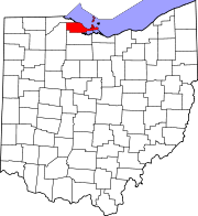
Location in the state of Ohio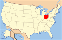
Ohio's location in the U.S.Founded March 6, 1840[1] Named for the Ottawa tribe or a word meaning "trader" Seat Port Clinton Largest city Port Clinton Area
- Total
- Land
- Water
585 sq mi (1,515 km²)
255 sq mi (660 km²)
330 sq mi (855 km²), 56.43%Population
- (2000)
- Density
40,985
161/sq mi (62/km²)Time zone Eastern: UTC-5/-4 Website www.co.ottawa.oh.us Historical populations Census Pop. %± 1840 2,248 — 1850 3,308 47.2% 1860 7,016 112.1% 1870 13,364 90.5% 1880 19,762 47.9% 1890 21,974 11.2% 1900 22,213 1.1% 1910 22,360 0.7% 1920 22,193 −0.7% 1930 24,109 8.6% 1940 24,360 1.0% 1950 29,469 21.0% 1960 35,323 19.9% 1970 37,099 5.0% 1980 40,076 8.0% 1990 40,029 −0.1% 2000 40,985 2.4% Est. 2007 41,084 0.2% Population 1800-2007.[1] Ottawa County is a county located in the state of Ohio, United States. As of the 2010 census, the population was 41,428. [1] Its county seat is Port Clinton[2] and is named either for the Ottawa Indians who lived there, or for an Indian word meaning "trader".[3]
Ottawa County is part of the Toledo Metropolitan Statistical Area.
Contents
History
On September 10, 1813, during the War of 1812, nine vessels of the United States Navy under Commodore Oliver Hazard Perry, decisively defeated six vessels of Great Britain’s Royal Navy in the Battle of Lake Erie near Put-in-Bay. This action was one of the major battles of the war.
Geography
According to the U.S. Census Bureau, the county has a total area of 585 square miles (1,515 km²).255 square miles (660 km²) of it is land and 330 square miles (855 km²) of it (56.43%) is water.
Adjacent counties
- Across Lake Erie lies Essex County, Ontario, Canada (north and east)
- Erie County (southeast)
- Sandusky County (south)
- Wood County (west)
- Lucas County (northwest)
National protected areas
Demographics
As of the census[4] of 2000, there were 40,985 people, 16,474 households, and 11,729 families residing in the county. The population density was 161 people per square mile (62/km²). There were 25,532 housing units at an average density of 100 per square mile (39/km²). The racial makeup of the county was 96.56% White, 0.65% Black or African American, 0.21% Native American, 0.23% Asian, 0.05% Pacific Islander, 1.44% from other races, and 0.87% from two or more races. 3.75% of the population were Hispanic or Latino of any race.
There were 16,474 households out of which 29.10% had children under the age of 18 living with them, 58.90% were married couples living together, 8.50% had a female householder with no husband present, and 28.80% were non-families. 25.00% of all households were made up of individuals and 11.20% had someone living alone who was 65 years of age or older. The average household size was 2.45 and the average family size was 2.92.
In the county, the population was spread out with 23.30% under the age of 18, 6.70% from 18 to 24, 26.80% from 25 to 44, 26.80% from 45 to 64, and 16.40% who were 65 years of age or older. The median age was 41 years. For every 100 females there were 97.50 males. For every 100 females age 18 and over, there were 94.70 males.
The median income for a household in the county was $44,224, and the median income for a family was $51,919. Males had a median income of $39,823 versus $24,727 for females. The per capita income for the county was $21,973. About 4.20% of families and 5.90% of the population were below the poverty line, including 7.40% of those under age 18 and 5.40% of those age 65 or over.
Government
Communities
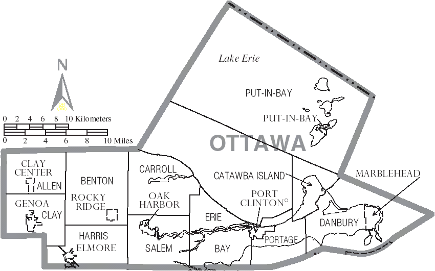
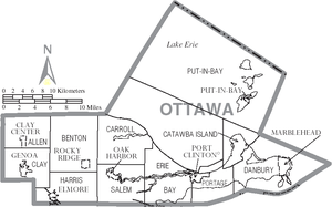 Map of Ottawa County, Ohio With Municipal and Township Labels
City
Villages
Townships
Unincorporated communities
- Blackberry Corner
- Camp Perry
- Catawba Island
- Curtice
- Danbury
- Elliston[5]
- Forest Park
- Graytown
- Grodis Corner
- Gypsum
- Hickory Grove
- Isle St. George
- Lacarne
- Lakeside
- Limestone
- Locust Point
- Martin
- Middle Bass
- Trowbridge
- Williston
- Yale
Transportation
Major highways
Other highways
Airports
- Erie-Ottawa Regional Airport
- Middle Bass-East Point Airport
- Middle Bass Island Airport
- North Bass Island Airport
- Put-in-Bay Airport
Notable residents
- Crystal Bowersox - singer-songwriter, 2010 American Idol runner-up, from Elliston
- Louis C. Shepard - American Civil War Medal of Honor recipient from Ashtabula County, buried in Lakeview cemetery, Port Clinton, Ohio.
See also
References
- ^ a b "Ohio County Profiles: Ottawa County" (PDF). Ohio Department of Development. http://www.odod.state.oh.us/research/FILES/S0/Ottawa.pdf. Retrieved 2007-04-28.
- ^ "Find a County". National Association of Counties. http://www.naco.org/Counties/Pages/FindACounty.aspx. Retrieved 2011-06-07.
- ^ "Ottawa County data". Ohio State University Extension Data Center. http://www.osuedc.org/profiles/profile_entrance.php?fips=39123&sid=0. Retrieved 2007-04-28.[dead link]
- ^ "American FactFinder". United States Census Bureau. http://factfinder.census.gov. Retrieved 2008-01-31.
- ^ "Trinity United Church of Christ (Elliston, Ohio)". Bowling Green State University. http://www.bgsu.edu/colleges/library/cac/ms/page43400.html. Retrieved 2010-03-09.

Lucas County Lake Erie Wood County 
 Ottawa County, Ohio

Sandusky County Erie County
Municipalities and communities of Ottawa County, Ohio City 
Villages Clay Center | Elmore‡ | Genoa | Marblehead | Oak Harbor | Put-in-Bay | Rocky Ridge
Townships Unincorporated
communitiesCurtice | Forest Park | Graytown | Gypsum | Isle St. George | Lacarne | Lakeside | Martin | Middle Bass | Williston
Footnotes ‡This populated place also has portions in an adjacent county or counties
Categories:- Ohio counties
- Ottawa County, Ohio
- 1840 establishments in the United States
- Populated places established in 1840
- Toledo metropolitan area


Wikimedia Foundation. 2010.