- Coshocton County, Ohio
-
Coshocton County, Ohio 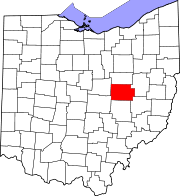
Location in the state of Ohio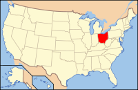
Ohio's location in the U.S.Founded January 31, 1810[1] Named for "union of waters" or "black bear crossing" in Delaware (Lenape) language Seat Coshocton Largest city Coshocton Area
- Total
- Land
- Water
568 sq mi (1,470 km²)
564 sq mi (1,461 km²)
4 sq mi (9 km²), 0.62Population
- (2000)
- Density
36,655
65/sq mi (25/km²)Time zone Eastern: UTC-5/-4 Website www.co.coshocton.oh.us Historical populations Census Pop. %± 1820 7,086 — 1830 11,161 57.5% 1840 21,590 93.4% 1850 25,674 18.9% 1860 25,032 −2.5% 1870 23,600 −5.7% 1880 26,642 12.9% 1890 26,703 0.2% 1900 29,337 9.9% 1910 30,121 2.7% 1920 29,595 −1.7% 1930 28,976 −2.1% 1940 30,594 5.6% 1950 31,141 1.8% 1960 32,224 3.5% 1970 33,486 3.9% 1980 36,024 7.6% 1990 35,427 −1.7% 2000 36,655 3.5% Coshocton County is a county located in the state of Ohio, United States. As of the 2010 census, the population was 36,901. [1] Its county seat is Coshocton.[2] Its name comes from the Delaware Indian language and has been translated as "union of waters" or "black bear crossing".[3]
The Coshocton Micropolitan Statistical Area includes all of Coshocton County.
Contents
Geography
According to the U.S. Census Bureau, the county has a total area of 568 square miles (1,471.1 km2).564 square miles (1,460.8 km2) is land and 4 square miles (10.4 km2) (0.62%) is water.
Adjacent counties
- Holmes County (north)
- Tuscawaras County (east)
- Guernsey County (southeast)
- Muskingum County (south)
- Licking County (southwest)
- Knox County (west)
History
Coshocton County was formed on January 31, 1810 from portions of Muskingum and Tuscarawas counties. Its name is derived from a Delaware Indian word that roughly means "union of waters."[citation needed]
Demographics
As of the census[4] of 2000, there were 36,655 people, 14,356 households, and 10,164 families residing in the county. The population density was 65 people per square mile (25/km²). There were 16,107 housing units at an average density of 29 per square mile (11/km²). The racial makeup of the county was 97.35% White, 1.09% Black or African American, 0.17% Native American, 0.32% Asian, 0.03% Pacific Islander, 0.20% from other races, and 0.84% from two or more races. 0.59% of the population were Hispanic or Latino of any race. 29.4% were of German, 23.4% American, 11.6% English and 9.3% Irish ancestry according to Census 2000. 93.9% spoke English, 2.4% German and 1.5% Pennsylvania Dutch as their first language.
There were 14,356 households out of which 32.60% had children under the age of 18 living with them, 57.80% were married couples living together, 9.20% had a female householder with no husband present, and 29.20% were non-families. 25.40% of all households were made up of individuals and 11.90% had someone living alone who was 65 years of age or older. The average household size was 2.52 and the average family size was 3.01.
In the county the population was spread out with 26.20% under the age of 18, 7.80% from 18 to 24, 27.40% from 25 to 44, 24.00% from 45 to 64, and 14.70% who were 65 years of age or older. The median age was 38 years. For every 100 females there were 95.50 males. For every 100 females age 18 and over, there were 92.70 males.
The median income for a household in the county was $34,701, and the median income for a family was $41,676. Males had a median income of $31,095 versus $21,276 for females. The per capita income for the county was $16,364. About 7.00% of families and 9.10% of the population were below the poverty line, including 10.40% of those under age 18 and 9.10% of those age 65 or over.
Government
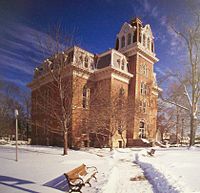 The courthouse in Coshocton, Ohio.
 Main article: Ohio county government
The county courts meet in the courthouse located in Coshocton. Built in 1875, it is still in use today.
Communities
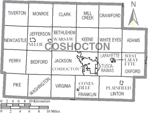 Map of Coshocton County, Ohio With Municipal and Township Labels
City
Villages
Townships
Unincorporated communities
See also
References
- ^ "Ohio County Profiles: Coshocton County" (PDF). Ohio Department of Development. http://www.odod.state.oh.us/research/FILES/S0/Coshocton.pdf. Retrieved 2007-04-28.
- ^ "Find a County". National Association of Counties. http://www.naco.org/Counties/Pages/FindACounty.aspx. Retrieved 2011-06-07.
- ^ "Coshocton County data". Ohio State University Extension Data Center. http://www.osuedc.org/profiles/profile_entrance.php?fips=39031&sid=0. Retrieved 2007-04-28.[dead link]
- ^ "American FactFinder". United States Census Bureau. http://factfinder.census.gov. Retrieved 2008-01-31.
External links

Holmes County Knox County 
Tuscarawas County  Coshocton County, Ohio

Licking County Muskingum County Guernsey County Municipalities and communities of Coshocton County, Ohio City 
Villages Baltic‡ | Conesville | Nellie | Plainfield | Warsaw | West Lafayette
Townships Unincorporated
communitiesBakersville | Blissfield | Fresno | Keene | Tunnel Hill | Wakatomika | Walhonding
Footnotes ‡This populated place also has portions in an adjacent county or counties
Categories:- Ohio counties
- Coshocton County, Ohio
- 1810 establishments in the United States
- Populated places established in 1810


Wikimedia Foundation. 2010.