- List of counties in Ohio
-
 Counties of Ohio
This is a list of the eighty-eight counties in the U.S. state of Ohio. The Ohio Constitution allows counties to set up a charter government as many cities and villages do, but only Summit County and Cuyahoga County have done so, the latter having been approved by voters in November 2009 but not yet implemented.[1] Counties do not possess home rule powers and can do only what has been expressly authorized by the Ohio General Assembly. Ohio law defines a structure for county government, although each county may choose to define its own. Summit County and Cuyahoga County have chosen an alternate structure, while all of the other counties use the default structure. The elected county officials include three commissioners, a sheriff (the highest law enforcement officer in the county); prosecutor (equivalent of a district attorney in other states); coroner, engineer, auditor, treasurer and clerk of courts.
The Federal Information Processing Standard (FIPS) code, which is used by the United States government to identify states and counties uniquely, is provided with each entry.[2] Ohio's code is 39, which when combined with any county code would be written as 39XXX. The FIPS code for each county links to census data for that county.
List of counties
County FIPS Code
[3]County Seat
[4]Created
[4][5]Origin
[6]Etymology
[5][6]Population
[3][4]Area
[4]Map
Adams County 001 West Union July 10, 1797 Hamilton County John Adams (1735-1826), second U.S. President and executive when the county was organized 28,550 583.91 sq mi
(1,512 km2)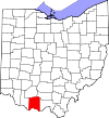
Allen County 003 Lima March 1, 1820 Shelby County John Allen (1771/2-1813), a War of 1812 colonel[7] 106,331 404.43 sq mi
(1,047 km2)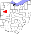
Ashland County 005 Ashland February 24, 1846 Wayne, Richland, Huron, and Lorain Counties Ashland, home of U.S. Senator from Kentucky Henry Clay. 53,139 424.37 sq mi
(1,099 km2)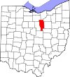
Ashtabula County 007 Jefferson June 7, 1807 Trumbull and Geauga Counties Ashtabula River, which means "fish river" in an Algonquian language[8] 101,497 702.44 sq mi
(1,819 km2)
Athens County 009 Athens March 1, 1805 Washington County Athens, Greece 64,757 506.76 sq mi
(1,313 km2)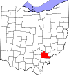
Auglaize County 011 Wapakoneta February 14, 1848 Allen, Mercer, Darke, Hardin, Logan, Shelby, and Van Wert Counties Auglaize River, which means "fallen timbers river" to the Shawnee 45,949 401.25 sq mi
(1,039 km2)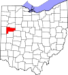
Belmont County 013 St. Clairsville September 7, 1801 Jefferson and Washington Counties Belle monte, which means "beautiful mountain" in French 70,400 537.35 sq mi
(1,392 km2)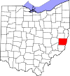
Brown County 015 Georgetown March 1, 1818 Adams and Clermont Counties General Jacob Brown (1775-1828), an officer of the War of 1812 44,846 491.76 sq mi
(1,274 km2)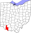
Butler County 017 Hamilton May 1, 1803 Hamilton County General Richard Butler (1743-1791), killed at the Battle of the Wabash 368,130 467.27 sq mi
(1,210 km2)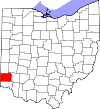
Carroll County 019 Carrollton January 1, 1833 Columbiana, Stark, Harrison, Jefferson, and Tuscarawas Counties Charles Carroll (1737-1832), last surviving signer of the United States Declaration of Independence 28,836 394.67 sq mi
(1,022 km2)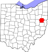
Champaign County 021 Urbana March 1, 1805 Greene and Franklin Counties French for "a plain", describing the land in the area 40,097 428.56 sq mi
(1,110 km2)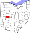
Clark County 023 Springfield March 1, 1818 Champaign, Madison, and Greene Counties General George Rogers Clark (1752-1818), defeated the Shawnee Indians in a battle near the Springfield area 138,333 399.86 sq mi
(1,036 km2)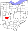
Clermont County 025 Batavia December 6, 1800 Hamilton County French for "clear mountain" 197,363 451.99 sq mi
(1,171 km2)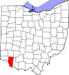
Clinton County 027 Wilmington March 1, 1810 Highland and Warren Counties George Clinton (1739-1812), vice-president when the county was organized 42,040 410.88 sq mi
(1,064 km2)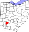
Columbiana County 029 Lisbon May 1, 1803 Jefferson and Washington Counties Derived from the words Christopher Columbus, European explorer of the Americas 107,841 532.46 sq mi
(1,379 km2)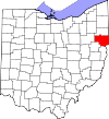
Coshocton County 031 Coshocton January 31, 1810 Muskingum and Tuscarawas Counties Delaware Indian word meaning "union of waters" 36,901 564.07 sq mi
(1,461 km2)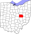
Crawford County 033 Bucyrus April 1, 1820 Delaware County Colonel William Crawford (1732-1782), Revolutionary War officer 43,784 402.11 sq mi
(1,041 km2)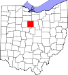
Cuyahoga County 035 Cleveland June 7, 1807 Geauga County Cuyahoga River, which means "crooked river" in an Iroquoian language[9] 1,280,122 458.49 sq mi
(1,187 km2)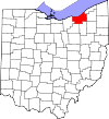
Darke County 037 Greenville January 3, 1809 Miami County General William Darke (1736-1801), Revolutionary War officer 52,959 599.80 sq mi
(1,553 km2)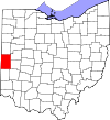
Defiance County 039 Defiance April 7, 1845 Williams, Henry, and Paulding Counties Fort Defiance, built in 1794 by General Anthony Wayne 39,037 411.16 sq mi
(1,065 km2)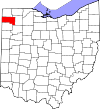
Delaware County 041 Delaware April 1, 1808 Franklin County Delaware Indians 174,214 442.41 sq mi
(1,146 km2)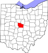
Erie County 043 Sandusky March 15, 1838 Huron and Sandusky Counties Erie Indians 77,079 254.88 sq mi
(660 km2)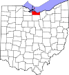
Fairfield County 045 Lancaster December 9, 1800 Ross and Washington Counties Named for the beauty of its "fair fields" 146,159 505.11 sq mi
(1,308 km2)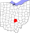
Fayette County 047 Washington Court House March 1, 1810 Ross and Highland Counties Marquis de Lafayette, French military officer and aristocrat who participated in both the American and French revolutions. 29,030 406.58 sq mi
(1,053 km2)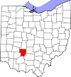
Franklin County 049 Columbus April 30, 1803 Ross and Wayne Counties Benjamin Franklin (1706-1791) - Founding Father, author, printer, satirist, political theorist, scientist, inventor and statesman. 1,163,414 539.87 sq mi
(1,398 km2)
Fulton County 051 Wauseon April 1, 1850 Lucas, Henry, and Williams Counties Robert Fulton (1765–1815), inventor of the steamboat 42,698 406.78 sq mi
(1,054 km2)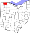
Gallia County 053 Gallipolis April 30, 1803 Washington and Adams Counties Gaul, the ancient name of France 30,934 468.78 sq mi
(1,214 km2)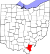
Geauga County 055 Chardon March 1, 1806 Trumbull County A Native American word meaning "raccoon" 93,389 403.66 sq mi
(1,045 km2)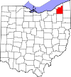
Greene County 057 Xenia May 1, 1803 Hamilton and Ross Counties General Nathanael Greene (1742-1786), Revolutionary War officer 161,573 414.88 sq mi
(1,075 km2)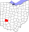
Guernsey County 059 Cambridge March 1, 1810 Belmont and Muskingum Counties Island of Guernsey, from where most of the settlers originated 40,087 521.90 sq mi
(1,352 km2)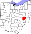
Hamilton County 061 Cincinnati January 2, 1790 One of the original counties Alexander Hamilton (1755/7-1804), Secretary of the Treasury when the county was organized 802,374 407.36 sq mi
(1,055 km2)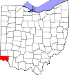
Hancock County 063 Findlay April 1, 1820 Logan County John Hancock (1737-1793), president of the Continental Congress 74,782 531.35 sq mi
(1,376 km2)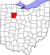
Hardin County 065 Kenton April 1, 1820 Logan County General John Hardin (1753–1792), Revolutionary War officer 32,058 470.29 sq mi
(1,218 km2)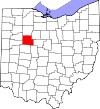
Harrison County 067 Cadiz February 1, 1813 Jefferson and Tuscarawas Counties General William Henry Harrison (1773–1841), an officer of the War of 1812 and future U.S. President 15,864 403.53 sq mi
(1,045 km2)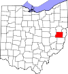
Henry County 069 Napoleon April 1, 1820 Shelby County Patrick Henry (1736–1799), Revolutionary War-era legislator, orator, and scholar 28,215 416.50 sq mi
(1,079 km2)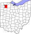
Highland County 071 Hillsboro May 1, 1805 Ross, Adams, and Clermont Counties Descriptive of the county's terrain 43,589 553.28 sq mi
(1,433 km2)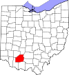
Hocking County 073 Logan March 1, 1818 Athens, Ross, and Fairfield Counties Possibly derived from the Delaware Indian word "Hoch-Hoch-ing", meaning "bottle" 29,380 422.75 sq mi
(1,095 km2)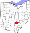
Holmes County 075 Millersburg January 20, 1824 Coshocton, Wayne, and Tuscarawas Counties Major Andrew Holmes (d. 1814), a War of 1812 officer 42,366 422.99 sq mi
(1,096 km2)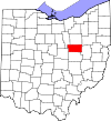
Huron County 077 Norwalk March 7, 1809 Portage and Cuyahoga Counties Huron Indians 59,626 492.69 sq mi
(1,276 km2)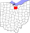
Jackson County 079 Jackson March 1, 1816 Scioto, Gallia, Athens, and Ross Counties General Andrew Jackson (1767–1845) 33,225 420.28 sq mi
(1,089 km2)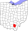
Jefferson County 081 Steubenville July 29, 1797 Washington County Thomas Jefferson (1743–1826), Vice President when the county was organized, future U.S. President, and principal author of the Declaration of Independence 69,709 409.61 sq mi
(1,061 km2)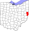
Knox County 083 Mount Vernon March 1, 1808 Fairfield County General Henry Knox, the first Secretary of War 60,921 527.12 sq mi
(1,365 km2)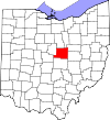
Lake County 085 Painesville March 6, 1840 Geauga and Cuyahoga Counties Named as such due to it bordering Lake Erie 230,041 228.21 sq mi
(591 km2)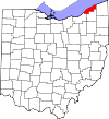
Lawrence County 087 Ironton December 21, 1815 Gallia and Scioto Counties Captain James Lawrence (1781–1813), naval hero in the War of 1812 62,450 454.96 sq mi
(1,178 km2)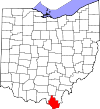
Licking County 089 Newark March 1, 1808 Fairfield County Named for the salt licks in the area 166,492 686.50 sq mi
(1,778 km2)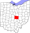
Logan County 091 Bellefontaine March 1, 1818 Champaign County General Benjamin Logan (c.1742–1802) , who destroyed Shawnee Indian towns in the county 45,858 458.44 sq mi
(1,187 km2)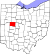
Lorain County 093 Elyria December 26, 1822 Huron, Cuyahoga, and Medina Counties Province of Lorraine, France 301,356 492.50 sq mi
(1,276 km2)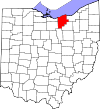
Lucas County 095 Toledo June 20, 1835 Wood, Sandusky, and Huron Counties Robert Lucas (1781–1853), Governor of Ohio when the county was created 441,815 340.46 sq mi
(882 km2)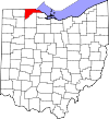
Madison County 097 London March 1, 1810 Franklin County James Madison (1751-1836), fourth U.S. President 43,435 465.44 sq mi
(1,205 km2)
Mahoning County 099 Youngstown March 1, 1846 Columbiana and Trumbull Counties Mahoning River, from a Native American word meaning "at the licks" 238,823 415.25 sq mi
(1,075 km2)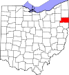
Marion County 101 Marion April 1, 1820 Delaware County General Francis Marion (1732-1795), lieutenant colonel in the Continental Army and later brigadier general in the American Revolutionary War. 66,501 403.84 sq mi
(1,046 km2)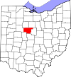
Medina County 103 Medina February 18, 1812 Portage County Medina, world-renowned religious site and capital of the Al Madinah Province in western Saudi Arabia 172,332 421.55 sq mi
(1,092 km2)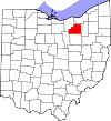
Meigs County 105 Pomeroy April 1, 1819 Gallia and Athens Counties Return Jonathan Meigs, Jr. (1764-1825), Governor of Ohio and Postmaster General at the time the county was organized 23,770 429.42 sq mi
(1,112 km2)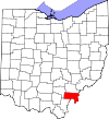
Mercer County 107 Celina April 1, 1820 Darke County General Hugh Mercer (1726-1777), a Revolutionary War officer 40,814 463.27 sq mi
(1,200 km2)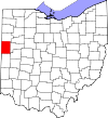
Miami County 109 Troy March 1, 1807 Montgomery County Miami Indians 102,506 407.04 sq mi
(1,054 km2)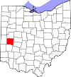
Monroe County 111 Woodsfield January 29, 1813 Belmont, Washington, and Guernsey Counties James Monroe (1758-1831), Secretary of State when the county was organized and future U.S. President 14,642 455.54 sq mi
(1,180 km2)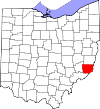
Montgomery County 113 Dayton May 1, 1803 Hamilton and Wayne Counties General Richard Montgomery (1738-1775), a Revolutionary War officer 535,153 461.68 sq mi
(1,196 km2)
Morgan County 115 McConnelsville December 29, 1817 Washington, Guernsey, and Muskingum Counties General Daniel Morgan (c.1735–1802), a Revolutionary War officer 15,054 417.66 sq mi
(1,082 km2)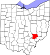
Morrow County 117 Mount Gilead March 1, 1848 Knox, Marion, Delaware, and Richland Counties Jeremiah Morrow (1771–1852), Governor of Ohio 34,827 406.22 sq mi
(1,052 km2)
Muskingum County 119 Zanesville March 1, 1803 Washington and Fairfield Counties A Native American word meaning "A town by the river"
or
a Native American word meaning "by the river side"86,074 664.63 sq mi
(1,721 km2)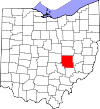
Noble County 121 Caldwell April 1, 1851 Monroe, Washington, Morgan, and Guernsey Counties James Noble (1785–1831), an early settler and future U.S. Senator from Indiana 14,645 399.00 sq mi
(1,033 km2)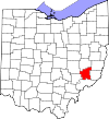
Ottawa County 123 Port Clinton March 6, 1840 Erie, Sandusky, and Lucas Counties Named for the Ottawa Indians; Ottawa means "trader" in their language 41,428 254.95 sq mi
(660 km2)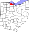
Paulding County 125 Paulding April 1, 1820 Darke County John Paulding (1758–1818), captor of spy John André during the Revolutionary War 19,614 416.26 sq mi
(1,078 km2)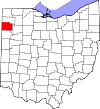
Perry County 127 New Lexington March 1, 1818 Washington, Fairfield, and Muskingum Counties Commodore Oliver Hazard Perry (1785–1819), a naval officer of the War of 1812 36,058 409.78 sq mi
(1,061 km2)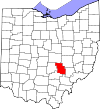
Pickaway County 129 Circleville March 1, 1810 Ross, Fairfield, and Franklin Counties A misspelling of the Piqua tribe, a branch of the Shawnee
or
A variant of a Native American word "Piqua"55,698 501.91 sq mi
(1,300 km2)
Pike County 131 Waverly February 1, 1815 Ross, Scioto, and Adams Counties General Zebulon M. Pike (1779–1813), a Revolutionary War officer and discoverer of Pikes Peak in Colorado in 1806 28,709 441.49 sq mi
(1,143 km2)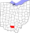
Portage County 133 Ravenna June 7, 1807 Trumbull County Derived from an Indian portage 161,419 492.39 sq mi
(1,275 km2)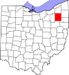
Preble County 135 Eaton March 1, 1808 Montgomery and Butler Counties Captain Edward Preble (1761-1807), a Naval commander in the Revolutionary War 42,270 424.80 sq mi
(1,100 km2)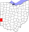
Putnam County 137 Ottawa April 1, 1820 Shelby County General Israel Putnam (1718–1790), a Revolutionary War officer 34,499 483.87 sq mi
(1,253 km2)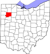
Richland County 139 Mansfield March 1, 1808 Fairfield County Descriptive of the soil in the area 124,475 496.88 sq mi
(1,287 km2)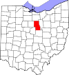
Ross County 141 Chillicothe August 20, 1798 Adams and Washington Counties Named for U.S. Senator from Pennsylvania James Ross by territorial governor Arthur St. Clair 78,064 688.41 sq mi
(1,783 km2)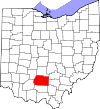
Sandusky County 143 Fremont April 1, 1820 Huron County An Iroquois word meaning "cold water" 60,944 409.18 sq mi
(1,060 km2)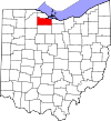
Scioto County 145 Portsmouth May 1, 1803 Adams County Scioto River; Scioto is a Wyandot word meaning "deer" 79,499 612.27 sq mi
(1,586 km2)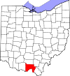
Seneca County 147 Tiffin April 1, 1820 Huron County Seneca Indians, who had a reservation in the county area at the time 56,745 550.59 sq mi
(1,426 km2)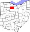
Shelby County 149 Sidney April 1, 1819 Miami County General Isaac Shelby (1750–1826), a Revolutionary War officer and Governor of Kentucky, 49,423 409.27 sq mi
(1,060 km2)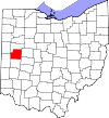
Stark County 151 Canton February 13, 1808 Columbiana County General John Stark (1728–1822) , a Revolutionary War officer; known as the "Hero of Bennington" for his exemplary service at the Battle of Bennington in 1777 375,586 576.14 sq mi
(1,492 km2)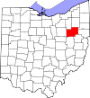
Summit County 153 Akron March 3, 1840 Medina, Portage, and Stark Counties Derived from having the highest elevation along the Ohio Canal 541,781 412.72 sq mi
(1,069 km2)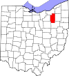
Trumbull County 155 Warren July 10, 1800 Jefferson and Wayne Counties Jonathan Trumbull (1710-1785), Governor of Connecticut when the county was organized 210,312 616.48 sq mi
(1,597 km2)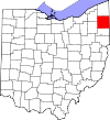
Tuscarawas County 157 New Philadelphia March 15, 1808 Muskingum County Tuscarawas River, meaning "open mouth river"
or
the Tuscarawas tribe who lived on the river92,582 567.58 sq mi
(1,470 km2)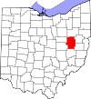
Union County 159 Marysville April 1, 1820 Delaware, Franklin, Logan, and Madison Counties Named as such due to it formed by a union of four counties 52,300 436.65 sq mi
(1,131 km2)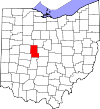
Van Wert County 161 Van Wert April 1, 1820 Darke County Isaac Van Wart (1760-1828), captor of spy John André during the Revolutionary War 28,744 410.09 sq mi
(1,062 km2)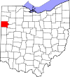
Vinton County 163 McArthur March 23, 1850 Athens, Gallia, Hocking, Jackson, and Ross Counties Samuel Finley Vinton (1792-1862), Ohio Statesman and U.S. Congressman 13,435 414.08 sq mi
(1,072 km2)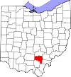
Warren County 165 Lebanon May 1, 1803 Hamilton County General Joseph Warren (1741-1775), a Revolutionary War officer 212,693 399.63 sq mi
(1,035 km2)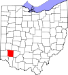
Washington County 167 Marietta July 27, 1788 One of the original counties George Washington (1732–1799), commander of the Continental Army, president of the Constitutional Convention, and future U.S. President 61,778 635.15 sq mi
(1,645 km2)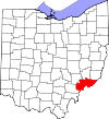
Wayne County 169 Wooster March 1, 1808 From non-county area General Anthony Wayne (1745–1796), a Revolutionary War officer 114,520 555.36 sq mi
(1,438 km2)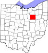
Williams County 171 Bryan April 1, 1820 Darke County David Williams (1754-1831), captor of spy John André during the Revolutionary War 37,642 421.74 sq mi
(1,092 km2)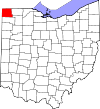
Wood County 173 Bowling Green April 1, 1820 Refactored from non-county territory Eleazer D. Wood (1783 -1814), founder of Fort Meigs 125,488 617.32 sq mi
(1,599 km2)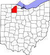
Wyandot County 175 Upper Sandusky February 3, 1845 Marion, Crawford, and Hardin Counties Wyandot Indians 22,615 405.61 sq mi
(1,051 km2)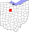
See also
- Ohio county government
- List of Ohio county name etymologies
- List of cities in Ohio
- List of Ohio townships
References
- ^ "Issue 6 reform wins big and sets in motion even bigger changes for Cuyahoga County". cleveland.com. http://www.cleveland.com/politics/index.ssf/2009/11/issue_6_reform_wins_big_and_se.html. Retrieved 2010-01-28.
- ^ "FIPS Publish 6-4". National Institute of Standards and Technology. http://www.itl.nist.gov/fipspubs/fip6-4.htm. Retrieved 2007-04-11.
- ^ a b "EPA County FIPS Code Listing". EPA. http://www.epa.gov/enviro/html/codes/tx.html. Retrieved 2007-04-09.
- ^ a b c d "NACo - Find a County". Archived from the original on 2007-04-13. http://web.archive.org/web/20070413041811/http://www.naco.org/Template.cfm?Section=Find_a_County&Template=/cffiles/counties/state.cfm&statecode=oh. Retrieved 2007-07-22.
- ^ a b "Federal Roster: Counties of Ohio, Derivation of Name and Date of Erection". http://www.sos.state.oh.us/SOS/PublicAffairs/fedRoster.aspx?Section=1585. Retrieved 2007-07-22.
- ^ a b "Ohio Genealogy Clickable County Map". Archived from the original on 2007-11-18. http://web.archive.org/web/20071118074514/http://www.rootsweb.com/~usgenweb/oh/1/counties.htm. Retrieved 2007-07-25.
- ^ Resolution of 111th Ohio General Assembly designating John Allen as the person for which Allen County was named.
- ^ Ashtabula, Encyclopædia Britannica, 2007. Accessed 2007-11-19.
- ^ Cuyahoga River, Encyclopædia Britannica, 2007. Accessed 2007-11-19.
- History of Ohio: From the Glacial Period to the Present Time. Press of F. J. Heer. 1905. http://books.google.com/books?id=cHgt2eYYXqwC&pg=PA6&dq=History+of+Ohio:+to+the+Present+Time#PPP1,M1. Retrieved 2007-08-18.
List of U.S. counties and county-equivalents
by political division (state / federal district)Alabama · Alaska · Arizona · Arkansas · California · Colorado · Connecticut · Delaware · District of Columbia · Florida · Georgia · Hawaii · Idaho · Illinois · Indiana · Iowa · Kansas · Kentucky · Louisiana · Maine · Maryland · Massachusetts · Michigan · Minnesota · Mississippi · Missouri · Montana · Nebraska · Nevada · New Hampshire · New Jersey · New Mexico · New York · North Carolina · North Dakota · Ohio · Oklahoma · Oregon · Pennsylvania · Rhode Island · South Carolina · South Dakota · Tennessee · Texas · Utah · Vermont · Virginia · Washington · West Virginia · Wisconsin · Wyoming
Categories:- Lists of U.S. counties by state
- Ohio counties
- Ohio-related lists


Wikimedia Foundation. 2010.