- Tuscarawas County, Ohio
-
Tuscarawas County, Ohio 
Location in the state of Ohio
Ohio's location in the U.S.Founded March 15, 1808[1] Named for Delaware Indian word variously translated as "old town" or "open mouth".[2] Seat New Philadelphia Largest city New Philadelphia Area
- Total
- Land
- Water
571 sq mi (1,480 km²)
568 sq mi (1,470 km²)
4 sq mi (10 km²), 0.68%Population
- (2000)
- Density
90,914
160/sq mi (62/km²)Time zone Eastern: UTC-5/-4 Website www.co.tuscarawas.oh.us Tuscarawas County is a county located in the eastern part of the state of Ohio. As of the 2010 census, the population was 92,582. [1] Its county seat is New Philadelphia[3]. Its name is a Delaware Indian word variously translated as "old town" or "open mouth".[2][4]
The New Philadelphia–Dover Micropolitan Statistical Area includes all of Tuscarawas County.
Contents
History
For years, European-American colonists on the East Coast did not know much about the territory west of the Appalachian Mountains except for reports from a few explorers and fur traders who ventured into the area. In 1750, Christopher Gist of the Ohio Land Company explored the Tuscarawas Valley. His report of the area hinted at some natural riches and friendly American Indians.
In 1761, missionaries from the Moravians, set out from Bethlehem, Pennsylvania to set up a mission in the Tuscarawas Valley. (This is also known as the Renewed Church of the United Brethren.) Christian Frederick Post and John Heckewelder met with Chief Newcomer (Netawatwees) of the western Lenape, also known as the Delaware. He invited them to the village he founded, Gekelemukpechunk (present-day Newcomerstown, Ohio. He granted the missionaries permission to build a cabin near the junction of the Sandy Creek and Tuscarawas River, in present-day Stark County. They were forced to abandon the mission in 1763 during the French and Indian War (part of the Seven Years War).
At the request of Chief Newcomer (Netawatwees), in 1771 David Zeisberger returned to found some missions in the valley. In the spring of 1772, near the present site of New Philadelphia, Ohio, Zeisberger along with five converted Indian families established Schoenbrunn (beautiful spring). They built a school house and a chapel. In August of that year, John Heckawelder brought an additional 250 converted Lenape Christians, who expanded the village of Schoenbrunn.
They established a second settlement, roughly 10 miles, called Gnadenhutten (cabins of grace). On October 17, 1772, Zeisberger conducted the first religious service at Gnadenhutten. In 1776, Chief Netawatwes donated land for another settlement, Lichtenau (meadow of light), near present-day Coshocton, then the principal Lenape village in the region.[5]
Tuscarawas County was formed from Muskingum County on Feb. 15, 1808.[6]
Geography
According to the U.S. Census Bureau, the county has a total area of 571 square miles (1,480 km2), of which 568 square miles (1,470 km²) are land and 4 square miles (10 km2) (0.68%) are water.
Adjacent counties
- Stark County (north)
- Carroll County (northeast)
- Harrison County (southeast)
- Guernsey County (south)
- Coshocton County (southwest)
- Holmes County (northwest)
Demographics
 Age pyramid of Tuscarawas County, based on 2000 census information.
As of the census[7] of 2000, there were 90,914 people, 35,653 households, and 25,313 families residing in the county. The population density was 160 people per square mile (62/km²). There were 38,113 housing units at an average density of 67 per square mile (26/km²). The racial makeup of the county was 97.87% White, 0.73% Black or African American, 0.17% Native American, 0.24% Asian, 0.05% Pacific Islander, 0.21% from other races, and 0.73% from two or more races. Hispanic or Latino of any race were 0.71% of the population. 95.3% spoke English, 1.3% German and 1.1% Spanish as their first language.
There were 35,653 households out of which 32.30% had children under the age of 18 living with them, 58.10% were married couples living together, 9.30% had a female householder with no husband present, and 29.00% were non-families. 24.90% of all households were made up of individuals and 11.50% had someone living alone who was 65 years of age or older. The average household size was 2.52 and the average family size was 3.01.
In the county, the population was spread out with 25.40% under the age of 18, 8.00% from 18 to 24, 28.10% from 25 to 44, 23.60% from 45 to 64, and 15.00% who were 65 years of age or older. The median age was 38 years. For every 100 females there were 95.10 males. For every 100 females age 18 and over, there were 91.40 males.
The median income for a household in the county was $35,489, and the median income for a family was $41,677. Males had a median income of $31,963 versus $20,549 for females. The per capita income for the county was $17,276. About 7.20% of families and 9.40% of the population were below the poverty line, including 12.20% of those under age 18 and 7.80% of those age 65 or over.
Historical populations Census Pop. %± 1810 3,045 — 1820 8,328 173.5% 1830 14,298 71.7% 1840 25,631 79.3% 1850 31,761 23.9% 1860 32,463 2.2% 1870 33,840 4.2% 1880 40,198 18.8% 1890 46,618 16.0% 1900 53,751 15.3% 1910 57,035 6.1% 1920 63,578 11.5% 1930 68,193 7.3% 1940 68,816 0.9% 1950 70,320 2.2% 1960 76,789 9.2% 1970 77,211 0.5% 1980 84,614 9.6% 1990 84,090 −0.6% 2000 90,914 8.1% Est. 2007 91,398 0.5% Population 1810-2007.[1] Hunting
Deer hunters consistently harvest a higher number of deer in Tuscarawas County than in any other county in Ohio.[8]
Government
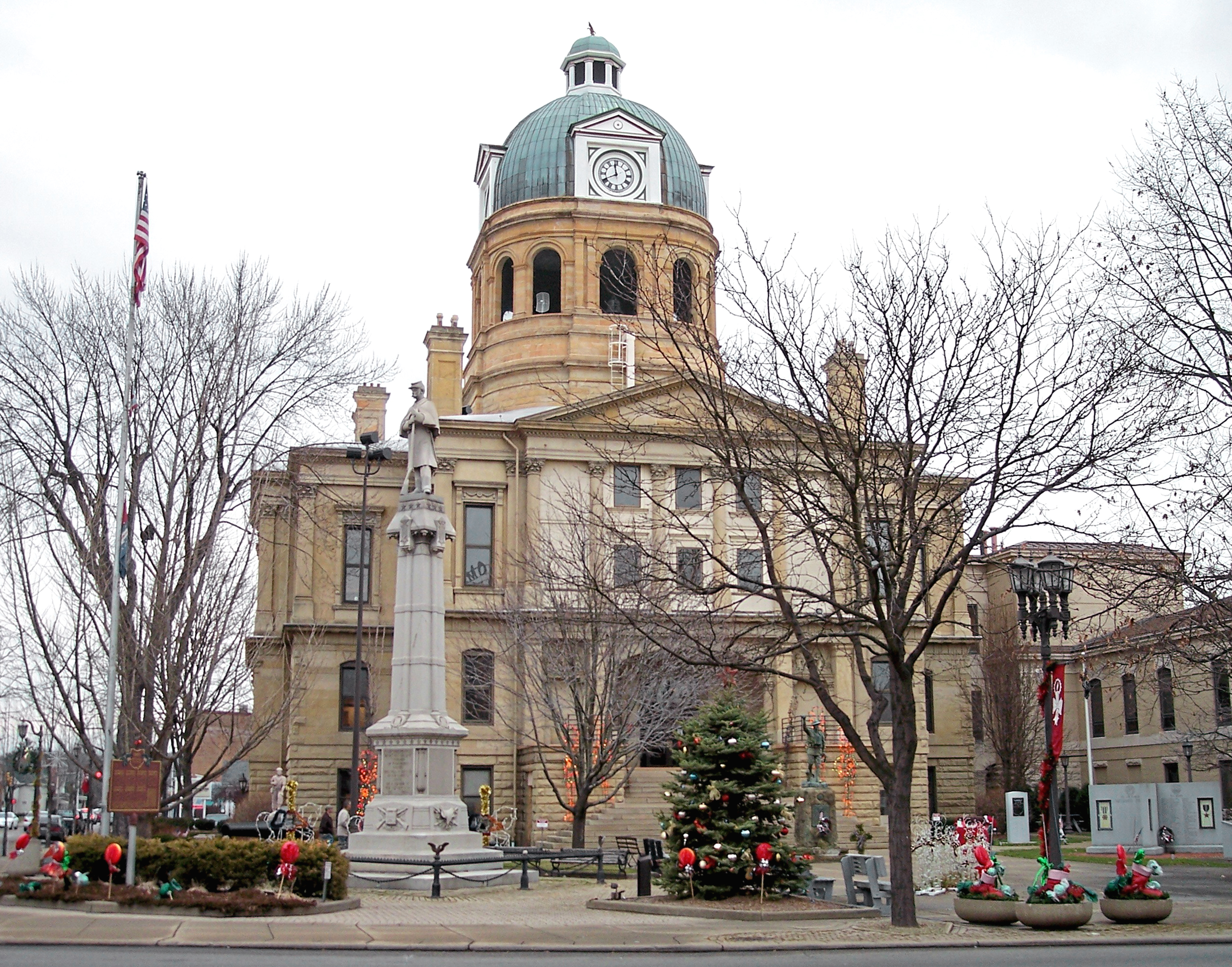
 Tuscarawas County CourthouseMain article: Ohio county government
Communities
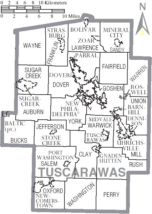
 Map of Tuscarawas County, Ohio With Municipal and Township Labels
Cities
Villages
Townships
Unincorporated communities
( West Chester
Fiat,Ohio Ragersville,Ohio See also
References
- ^ a b "Ohio County Profiles: Tuscarawas County" (PDF). Ohio Department of Development. http://www.odod.state.oh.us/research/FILES/S0/Tuscarawas.pdf. Retrieved 2007-04-28.
- ^ a b "The Export of Pennsylvania Placenames, William A. Russ, Jr.". http://cip.cornell.edu/DPubS/Repository/1.0/Disseminate/psu.ph/1130874805/body/pdf. Retrieved 2007-05-02.
- ^ "Find a County". National Association of Counties. http://www.naco.org/Counties/Pages/FindACounty.aspx. Retrieved 2011-06-07.
- ^ "Tuscarawas County data". Ohio State University Extension Data Center. http://www.osuedc.org/profiles/profile_entrance.php?fips=39157&sid=0. Retrieved 2007-04-28.[dead link]
- ^ Guide to Tuscarawas County, Federal Writers Project of Ohio Work Projects Administration, F.C. Harrington, Florence Kerr, Carl Watson, 1939
- ^ "Historical Collections of Ohio, Henry Howe". 1888. http://freepages.genealogy.rootsweb.ancestry.com/~henryhowesbook/tuscarawas.html. Retrieved 2010-04-27.
- ^ "American FactFinder". United States Census Bureau. http://factfinder.census.gov. Retrieved 2008-01-31.
- ^ http://www.timesreporter.com/local_news/x1355825770/Deer-kill-nears-6-000
Baltic ohio
External links
- Tuscarawas County Government's website
- Tuscarawas County Convention & Visitors Bureau's website
- Kent State University The Olmstead Collection, Tuscarawas County Historical Society
- Ohio and Erie Canal National Heritage Corridor, a National Park Service Discover Our Shared Heritage Travel Itinerary

Holmes County Stark County Carroll County 
 Tuscarawas County, Ohio

Coshocton County Guernsey County Harrison County Municipalities and communities of Tuscarawas County, Ohio Cities 
Villages Baltic‡ | Barnhill | Bolivar | Dennison | Gnadenhutten | Midvale | Mineral City | Newcomerstown | Parral | Port Washington | Roswell | Stone Creek | Strasburg | Sugarcreek | Tuscarawas | Zoar
Townships Unincorporated
communitiesBernice | Dundee | Gilmore | New Cumberland | Newport | Peoli | Sandyville | Somerdale | Stillwater | Wainwright
Footnotes ‡This populated place also has portions in an adjacent county or counties
Categories:- Ohio counties
- Tuscarawas County, Ohio
- 1808 establishments in the United States
- Populated places established in 1808


Wikimedia Foundation. 2010.