- Jefferson County, Ohio
-
Jefferson County, Ohio 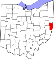
Location in the state of Ohio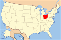
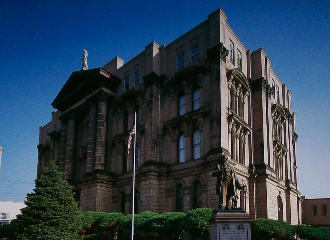
Ohio's location in the U.S.Founded July 29, 1797[1] Named for Thomas Jefferson Seat Steubenville Largest city Steubenville Area
- Total
- Land
- Water
411 sq mi (1,064 km²)
410 sq mi (1,061 km²)
1 sq mi (3 km²), 0.31%Population
- (2000)
- Density
73,894
180/sq mi (70/km²)Time zone Eastern: UTC-5/-4 Website www.jeffersoncountyoh.com Jefferson County is a county located in the state of Ohio. As of 2010, the population was 69,709. [1] Its county seat is Steubenville[2] and is named for Thomas Jefferson, who was at the time Vice President.[3]
Jefferson County is part of the Weirton-Steubenville, WV-OH Metropolitan Statistical Area.
Contents
History
Jefferson County was named for Thomas Jefferson, author of the Declaration of Independence, Secretary of State, and Vice President of the United States at the time of the County’s creation. It was organized on July 29, 1797 by proclamation of Governor Arthur St. Clair, six years before Ohio was granted statehood.
In 1786, the United States built Fort Steuben to protect the government surveyors mapping the land west of the Ohio River. When the surveyors completed their task a few years later, the fort was abandoned. In the meantime, settlers had built homes around the fort; they named their settlement La Belle. When the County was created in 1797, La Belle was selected as the County seat. The town was subsequently renamed Steubenville, in honor of the abandoned fort.
During the first half of the nineteenth century, Jefferson County attracted a number of pioneers who were looking for a better life in the newly developing lands west of the Ohio River. Included in those brave souls were a large number of American Revolution war veterans, as well as several groups of Quakers. For example, the villages of Mt. Pleasant and Smithfield were founded by Quakers, which became early centers for abolitionist activity.
During the first half of the nineteenth century, Steubenville was primarily a port town, and the rest of the county was small villages and farms. However, in 1856, Frazier, Kilgore and Company erected a rolling mill (the forerunner of steel mills) and the Steubenville Coal and Mining Company sank a coal shaft, resulting in Jefferson County becoming one of the leading centers of the new Industrial Revolution.
Jefferson County is a virtual treasure trove for history and genealogy researchers. It has over seventy pioneer cemeteries, the oldest Quaker meeting house west of the Ohio River, well preserved sites on the Underground Railroad, and the old Fort Steuben has been completely rebuilt as a public historic site and museum. Several of the towns and villages have formed historical societies, dedicated to preserving local history.
Click here to visit the Jefferson County Chapter of the Ohio Genealogical Society's Website[4]
Geography
According to the U.S. Census Bureau, the county has a total area of 411 square miles (1,064.5 km2).410 square miles (1,061.9 km2) is land and 1 square mile (2.6 km2) (0.31%) is water.
Adjacent counties
- Columbiana County (north)
- Hancock County, West Virginia (northeast)
- Brooke County, West Virginia (east)
- Ohio County, West Virginia (southeast)
- Belmont County (south)
- Harrison County (southwest)
- Carroll County (northwest)
Demographics
As of the census[5] of 2000, there were 73,894 people, 30,417 households, and 20,592 families residing in the county. The population density was 180 people per square mile (70/km²). There were 33,291 housing units at an average density of 81 per square mile (31/km²). The racial makeup of the county was 92.49% White, 5.68% Black or African American, 0.20% Native American, 0.33% Asian, 0.02% Pacific Islander, 0.25% from other races, and 1.03% from two or more races. 0.62% of the population were Hispanic or Latino of any race. 96.5% spoke English, 1.1% Spanish and 1.0% Italian as their first language.
There were 30,417 households out of which 26.70% had children under the age of 18 living with them, 52.30% were married couples living together, 11.60% had a female householder with no husband present, and 32.30% were non-families. 28.50% of all households were made up of individuals and 14.40% had someone living alone who was 65 years of age or older. The average household size was 2.36 and the average family size was 2.88.
Historical populations Census Pop. %± 1800 8,766 — 1810 17,260 96.9% 1820 18,531 7.4% 1830 22,489 21.4% 1840 25,030 11.3% 1850 29,133 16.4% 1860 26,115 −10.4% 1870 29,188 11.8% 1880 33,018 13.1% 1890 39,415 19.4% 1900 44,357 12.5% 1910 65,423 47.5% 1920 77,580 18.6% 1930 88,307 13.8% 1940 98,129 11.1% 1950 96,495 −1.7% 1960 99,201 2.8% 1970 96,193 −3.0% 1980 91,564 −4.8% 1990 80,298 −12.3% 2000 73,894 −8.0% Est. 2007 68,730 −7.0% In the county, the population was spread out with 21.40% under the age of 18, 8.50% from 18 to 24, 25.60% from 25 to 44, 25.90% from 45 to 64, and 18.60% who were 65 years of age or older. The median age was 42 years. For every 100 females there were 91.20 males. For every 100 females age 18 and over, there were 87.50 males.
The median income for a household in the county was $30,853, and the median income for a family was $38,807. Males had a median income of $35,785 versus $20,375 for females. The per capita income for the county was $16,476. About 11.40% of families and 15.10% of the population were below the poverty line, including 22.30% of those under age 18 and 8.90% of those age 65 or over.
Government
Commissioners: Thomas Graham, Ph.D, Dave Maple, and Adam Scurti
Prosecutor: Thomas Straus
Sheriff: Fred Abdalla
Auditor: Patrick J. Marshall
Treasurer: Raymond M. Agresta
Engineer: James Branagan
Judges of the Court of Common Pleas: Hon. Joseph J. Bruzzese Jr, Hon. David E. Henderson
Probate Court: Hon. Samuel W. Kerr
Clerk of Courts: John A. Corrigan
Health Commissioner: Frank J. Petrola, M.D.
Director, Board of Elections: Diane M. Gribble
Director, Job and Family Services: Nicholas Balakos
Director, Progress Alliance: Ed LoomanCommunities
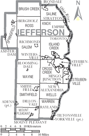 Map of Jefferson County, Ohio with Municipal and Township Labels
Cities
Villages
Townships
Unincorporated communities
See also
References
- ^ "Ohio County Profiles: Jefferson County" (PDF). Ohio Department of Development. http://www.odod.state.oh.us/research/FILES/S0/Jefferson.pdf. Retrieved 2007-04-28.
- ^ "Find a County". National Association of Counties. http://www.naco.org/Counties/Pages/FindACounty.aspx. Retrieved 2011-06-07.
- ^ "Jefferson County data". Ohio State University Extension Data Center. http://www.osuedc.org/profiles/profile_entrance.php?fips=39081&sid=0. Retrieved 2007-04-28.[dead link]
- ^ Jefferson County Chapter of the Ohio Genealogical Society
- ^ "American FactFinder". United States Census Bureau. http://factfinder.census.gov. Retrieved 2008-01-31.
External links

Carroll County Columbiana County Hancock County, West Virginia 
Brooke County, West Virginia  Jefferson County, Ohio

Harrison County Belmont County Ohio County, West Virginia Municipalities and communities of Jefferson County, Ohio Cities 
Villages Adena‡ | Amsterdam | Bergholz | Bloomingdale | Dillonvale | Empire | Irondale | Mingo Junction | Mount Pleasant | New Alexandria | Rayland | Richmond | Smithfield | Stratton | Tiltonsville | Wintersville | Yorkville‡
Townships Brush Creek | Cross Creek | Island Creek | Knox | Mount Pleasant | Ross | Salem | Saline | Smithfield | Springfield | Steubenville | Warren | Wayne | Wells
Unincorporated
communitiesBrilliant | East Springfield | Greentown | Hammondsville | Hopewell | New Somerset | Piney Fork | Rush Run | Wolf Run | Weems
Footnotes ‡This populated place also has portions in an adjacent county or counties
Categories:- Ohio counties
- 1797 establishments
- Jefferson County, Ohio
- Ohio River counties
- Weirton–Steubenville metropolitan area


Wikimedia Foundation. 2010.