- Darke County, Ohio
-
Darke County, Ohio 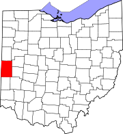
Location in the state of Ohio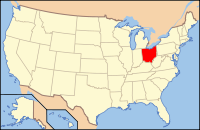
Ohio's location in the U.S.Founded January 3, 1809[1] Named for William Darke Seat Greenville Largest city Greenville Area
- Total
- Land
- Water
600 sq mi (1,555 km²)
600 sq mi (1,553 km²)
0 sq mi (2 km²), 0.08Population
- (2000)
- Density
53,309
89/sq mi (34/km²)Time zone Eastern: UTC-5/-4 Website www.co.darke.oh.us Darke County is a county located in the state of Ohio, United States. As of the 2010 census, the population was 52,959. [1] Its county seat is Greenville[2] and is named for William Darke, an officer in the Revolution.[3]
The Greenville Micropolitan Statistical Area includes all of Darke County.
Contents
Geography
According to the U.S. Census Bureau, the county has a total area of 600 square miles (1,554.0 km2), all land.
Adjacent counties
- Mercer County (north)
- Shelby County (northeast)
- Miami County (east)
- Montgomery County (southeast)
- Preble County (south)
- Wayne County, Indiana (southwest)
- Randolph County, Indiana (west)
- Jay County, Indiana (northwest)
Darke County, Ohio, is one of the few counties in the United States to border eight other counties.
Demographics
Historical populations Census Pop. %± 1820 3,622 — 1830 6,204 71.3% 1840 13,282 114.1% 1850 20,276 52.7% 1860 26,009 28.3% 1870 32,278 24.1% 1880 40,496 25.5% 1890 42,961 6.1% 1900 42,532 −1.0% 1910 42,933 0.9% 1920 42,911 −0.1% 1930 38,009 −11.4% 1940 38,831 2.2% 1950 41,799 7.6% 1960 45,612 9.1% 1970 49,141 7.7% 1980 55,096 12.1% 1990 53,619 −2.7% 2000 53,309 −0.6% As of the census[4] of 2000, there were 53,309 people, 20,419 households, and 14,905 families residing in the county. The population density was 89 people per square mile (34/km²). There were 21,583 housing units at an average density of 36 per square mile (14/km²). The racial makeup of the county was 98.09% White, 0.39% Black or African American, 0.17% Native American, 0.25% Asian, 0.02% Pacific Islander, 0.34% from other races, and 0.74% from two or more races. 0.86% of the population were Hispanic or Latino of any race. 43.1% were of German, 20.1% American, 8.1% English, 6.8% Irish and 5.8% French ancestry according to Census 2000.
There were 20,419 households out of which 33.30% had children under the age of 18 living with them, 61.00% were married couples living together, 8.00% had a female householder with no husband present, and 27.00% were non-families. 23.50% of all households were made up of individuals and 11.00% had someone living alone who was 65 years of age or older. The average household size was 2.56 and the average family size was 3.03.
In the county the population was spread out with 26.30% under the age of 18, 7.80% from 18 to 24, 27.50% from 25 to 44, 23.20% from 45 to 64, and 15.30% who were 65 years of age or older. The median age was 37 years. For every 100 females there were 96.10 males. For every 100 females age 18 and over, there were 93.30 males.
The median income for a household in the county was $39,307, and the median income for a family was $45,735. Males had a median income of $32,933 versus $23,339 for females. The per capita income for the county was $18,670. About 6.00% of families and 8.00% of the population were below the poverty line, including 10.10% of those under age 18 and 9.20% of those age 65 or over.
Government
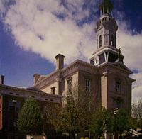 The county courthouse in Greenville.
 Main article: Ohio county government
Communities
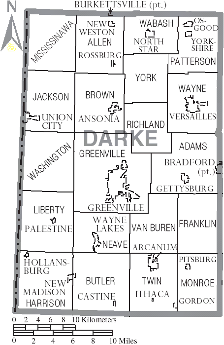
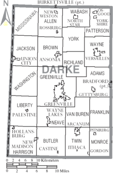 Map of Darke County, Ohio With Municipal and Township Labels
City
Villages
Townships
Other communities
- Abbottsville
- Baker
- Beamsville
- Braffettsville
- Brock
- Coletown
- Cosmos
- Dawn
- Delise
- Fort Jefferson
- Frenchtown
- Hillgrove
- Horatio
- Hunchbargers
- Rush's Station
- Savora
- Stelvideo
- Sharpeye
- Webster
- Woodington
Education
Public School Districts
- Ansonia Local Schools
- Ansonia High School, Ansonia (the Tigers)
- Arcanum-Butler Local School District
- Arcanum High School, Arcanum (the Trojans)
- Franklin Monroe Schools
- Franklin Monroe Middle School/High School, Pitsburg (the Jets)
- Greenville City School District
- Greenville Senior High School, Greenville (the Green Wave)
- Mississinawa Valley Local School District
- Mississinawa Valley Junior/Senior High School, Union City (the Blackhawks)
- Tri-Village Local School District
- Tri-Village High School, New Madison (the Patriots)
- Versailles Exempted Village Schools
- Versailles High School, Versailles (the Tigers)
Historic places
Darke County has 25 places listed on the National Register of Historic Places, including the Darke County Courthouse, Sheriff's House and Jail and the Versailles Town Hall and Wayne Township House.
Notable residents
- Annie Oakley - sharpshooter and exhibition shooter, born less than two miles northwest of Woodland,(now Willowdell)
- Lowell Thomas - writer, broadcaster, and traveler, born at Woodington
- Matt Light - New England Patriots lineman, 3 time Super Bowl champion, born in Greenville
See also
References
- ^ "Ohio County Profiles: Darke County" (PDF). Ohio Department of Development. http://www.odod.state.oh.us/research/FILES/S0/Darke.pdf. Retrieved 2007-04-28.
- ^ "Find a County". National Association of Counties. http://www.naco.org/Counties/Pages/FindACounty.aspx. Retrieved 2011-06-07.
- ^ "Darke County data". Ohio State University Extension Data Center. http://www.osuedc.org/profiles/profile_entrance.php?fips=39037&sid=0. Retrieved 2007-04-28.[dead link]
- ^ "American FactFinder". United States Census Bureau. http://factfinder.census.gov. Retrieved 2008-01-31.
External links

Jay County, Indiana Mercer County Shelby County Randolph County, Indiana 
Miami County  Darke County, Ohio

Wayne County, Indiana Preble County Montgomery County Municipalities and communities of Darke County, Ohio City 
Villages Ansonia | Arcanum | Bradford‡ | Burkettsville‡ | Castine | Gettysburg | Gordon | Hollansburg | Ithaca | New Madison | New Weston | North Star | Osgood | Palestine | Pitsburg | Rossburg | Union City | Versailles | Wayne Lakes | Yorkshire
Townships Unincorporated
communitiesBeamsville | Dawn | Frenchtown | Jaysville | Otterbein | Stelvideo
Footnotes ‡This populated place also has portions in an adjacent county or counties
Categories:- Ohio counties
- Darke County, Ohio
- 1809 establishments in the United States
- Populated places established in 1809


Wikimedia Foundation. 2010.