- Clermont County, Ohio
-
Clermont County, Ohio 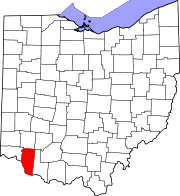
Location in the state of Ohio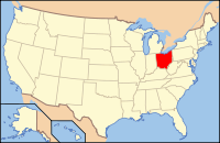
Ohio's location in the U.S.Founded December 6, 1800[1] Named for Clermont[disambiguation needed  ] in France or "clear mountain" in French
Seat Batavia Largest city Milford* Area
- Total
- Land
- Water
458 sq mi (1,185 km²)
452 sq mi (1,171 km²)
6 sq mi (16 km²), 1.24%Population
- (2010)
- Density
197,363
394/sq mi (152/km²)Time zone Eastern: UTC-5/-4 Website www.clermontcountyohio.gov Footnotes: *Based on population just within the county.[2] Clermont County is a county located in the state of Ohio, United States, just east of Cincinnati. As of 2010, the population was 197,363. Its county seat is Batavia.[3] The county is named either for a place in France or for the French for "clear mountain", though there are no mountains there.[4]
Clermont County is part of the Cincinnati–Middletown, OH-KY-IN Metropolitan Statistical Area.
Contents
History
Established in December 1800, Clermont County is the eighth oldest of Ohio's 88 counties, and is the eleventh oldest county in the Northwest Territory. Clermont is a French word meaning "clear mountain," which described the area when it was first viewed by French explorers in the 1600s.
The first village and the first Clermont County seat, was the Village of Williamsburg, established in 1796. In 1823, New Richmond became the county seat, and in 1824, it moved to Batavia, which remains the county seat today.
Clermont County has a rich historical past. A number of Native American tribes called this area home, including the Shawnee, Miami, Delaware, Mingo, Ottawa, Cherokee, and Wyandot. The last Native American village in the county was located two miles south of Marathon in Jackson Township, along the mouth of Grassy Run on the East Fork of the Little Miami River. The Wyandot lived there until 1811. That location was the site of the largest frontier battle in Clermont County, the Battle of Grassy Run, where pioneer Simon Kenton clashed with Native American warrior, Tecumseh, on April 10, 1792.
This area was also home to President and military hero, General Ulysses S. Grant, born in Point Pleasant on April 27, 1822. He became commander-in-chief of the U.S. Army during the Civil War, and was the eighteenth president of our country. His birthplace in Point Pleasant (originally a one room cabin) continues to welcome visitors today. In 1890, General Grants birthplace was removed from its original location, and traveled by boat to be viewed by citizens, along various waterways. It was also taken to the Chicago Worlds Fair, before making its way back to Clermont County.
There are numerous sites along the Ohio River in New Richmond, Moscow, and other communities that were prominent in the Underground Railroad. Pictured at right, local historian Gary Knepp stands near the Thomas Fee home in Moscow, which was once a stop for slaves making their way to freedom.
In 1905, John M. Pattison of Owensville, became the first Clermont Countian to be elected governor of Ohio. Pattison also lived in Milford, residing in a mansion that is known as Promont. That structure is now a museum that houses a library and other historical memorabilia. It is located at 906 Main Street in Milford.
A stone dairy house, built in 1800, is thought to be the oldest standing structure in Clermont County. It is located beside Harmony Hill on South Third Street in Williamsburg. Harmony Hill (one of the areas first farms) was built by William Lytle, who was one of the first surveyors of the county.
The last covered bridge in Clermont County proudly stands on Stonelick Williams Corner Road, near US 50; it was built in 1878.
Among other notable Clermont County citizens, Hugh Nichols of Batavia, was the first Chief Justice of the Ohio Supreme Court in 1914.
Clermont County has many other fascinating historical facts including: the Bullskin Trail (once a major pathway for Native Americans) runs north and south through the county along State Route 133, and was also used by frontiersmen Simon Kenton and Daniel Boone on hunting and warfare expeditions; John Hunt Morgan and his Confederate raiders invaded the county in 1863; George Washington once owned three parcels of land in Clermont County.
Geography
According to the U.S. Census Bureau, the county has a total area of 458 square miles (1,186.2 km2). 452 square miles (1,170.7 km2) is land and 6 square miles (15.5 km2) (1.24%) is water. Clermont County is considered to be part of Appalachian Ohio. [5]
Adjacent counties
- Warren County (north)
- Clinton County (north)
- Brown County (east)
- Bracken County, Kentucky (south)
- Pendleton County, Kentucky (southwest)
- Campbell County, Kentucky (southwest)
- Hamilton County (west)
Demographics
Historical populations Census Pop. %± 1810 9,965 — 1820 15,820 58.8% 1830 20,466 29.4% 1840 23,106 12.9% 1850 30,455 31.8% 1860 33,034 8.5% 1870 34,268 3.7% 1880 36,713 7.1% 1890 33,553 −8.6% 1900 31,610 −5.8% 1910 29,551 −6.5% 1920 28,291 −4.3% 1930 29,786 5.3% 1940 34,109 14.5% 1950 42,182 23.7% 1960 80,530 90.9% 1970 95,725 18.9% 1980 128,483 34.2% 1990 150,187 16.9% 2000 177,977 18.5% 2010 197,363 10.9% Population 1810-2007.[1] As of the census[6] of 2000, there were 177,977 people, 66,013 households, and 49,047 families residing in the county. The population density was 394 people per square mile (152/km²). There were 69,226 housing units at an average density of 153 per square mile (59/km²). The racial makeup of the county was 97.13% White, 0.91% African American, 0.19% Native American, 0.63% Asian, 0.02% Pacific Islander, 0.26% from other races, and 0.86% from two or more races. 0.87% of the population were Hispanic or Latino of any race. 32.7% were of German, 16.7% American, 12.0% Irish and 11.0% English ancestry according to Census 2000.
There were 66,013 households out of which 38.10% had children under the age of 18 living with them, 60.40% were married couples living together, 10.00% had a female householder with no husband present, and 25.70% were non-families. 21.00% of all households were made up of individuals and 7.00% had someone living alone who was 65 years of age or older. The average household size was 2.67 and the average family size was 3.11.
In the county the population was spread out with 27.90% under the age of 18, 8.40% from 18 to 24, 31.70% from 25 to 44, 22.60% from 45 to 64, and 9.40% who were 65 years of age or older. The median age was 35 years. For every 100 females there were 96.40 males. For every 100 females age 18 and over, there were 93.60 males.
The median income for a household in the county was $49,386, and the median income for a family was $57,032. Males had a median income of $40,739 versus $27,613 for females. The per capita income for the county was $22,370. About 5.30% of families and 7.10% of the population were below the poverty line, including 8.70% of those under age 18 and 7.90% of those age 65 or over.
Government
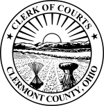 Seal of the Clermont County Clerk of Courts
As of March 2010, the Clermont County Commissioners are: Bob Proud, Ed Humphrey, and Archie Wilson.
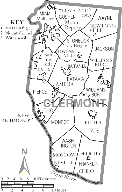
 Map of Clermont County, Ohio With Municipal and Township LabelsMain article: Ohio county government
Localities
Municipalities
Townships
Census-designated places
Other places
Here are stories and traditions behind how some of Clermont County's many communities received their names.
Afton: The name of this unincorporated community was suggested by Sarah Lytle, daughter of William Lytle, also known as "The Father of Clermont County". A popular song in the 1850s, which referred to "Sweet Afton," might be how Miss Lytle got the idea. A post office was established in this Williamsburg Township community in 1849 under the name of California. Afton is approximately one mile east of Williamsburg on Old S.R. 32.
Amelia was originally called Milltown because of several mills in the area. It wasn't long before the name was slurred into Milton, and when the village applied for a post office, it did so under that name. Since a "Milton" post office already existed in Ohio, another name was needed. The popular Amelia Bowdoin, who operated the tollgate on the Ohio Turnpike (State Route 125), was one of the better known persons in the community. The Amelia post office was established in February 1836. The village was incorporated in December, 1900. Amelia straddles S.R. 125 (Main Street), approximately six miles east of the Hamilton/Clermont County border.
Bantam received its name from Dr. Thomas Pinkham, whose family settled in the area, building a mansion in 1824. At that time Clermont factions were disputing the choice of Batavia or New Richmond as the county's seat. Pinkham offered to donate 1,000 acres (4 km2) for a "bantam-sized" community as a compromise location. However, Bantam never became the county seat. (Williamsburg, New Richmond and now Batavia, have been the county seats.) Bantam, an unincorporated area in Tate Township, is about three miles (5 km) west of Bethel on S.R. 125. It is on the southern edge of East Fork Lake State Park.
Batavia was named for Batavia, NY, previous home of some of the community's first settlers. Batavia is Clermont's third county seat. It incorporated as a village in February 1842. Batavia is at the intersection of State Routes 32, 132 and 222, approximately in the center of Clermont County. Most county offices are located in the village of Batavia and neighboring Batavia Township area, which is also home to the University of Cincinnati's Clermont College branch.
Belfast, an unincorporated community, received its name from early Irish settlers. The post office established here in March 1840, was given the name Belfast. Belfast is in Stonelick Township, approximately two miles west of Newtonsville on S.R. 131 at Goshen Pike. Belfast is one of the many rural communities that never had a "downtown" district but is simply considered a cross roads community however was once very active with the old White Gables Skating Rink in the mid 50's through the 80's.
Bethel was first named Plainfield, after Plainfield, New Jersey, the home town of village founder Obediah Denham. The named changed twice, first to Denhamstown in honor of its founder and finally to Bethel in 1802 when the village plat was recorded. Bethel is the site of the Bible story of Jacob's dream about the ladder to Heaven. Bethel was incorporated as a village in March, 1851. It is on S.R. 125, approximately three miles west of the Brown/Clermont County border.
Branch Hill was named after Col. John H. Branch who laid out the community in January 1873. This unincorporated area of Miami Township is on the Little Miami River near Interstate 275, about a mile and a half southeast of the city of Loveland.
Chilo's name origin is not certain. The village was originally called Mechanicsburg because - it is believed - mechanics who worked on steamboats lived there. The "Ch" is pronounced as in the word "chili." Chilo was laid out by Robert Bagby on May 1, 1816. The village was incorporated in 1968. It is on the Ohio River, about five miles (8 km) west of the Brown/Clermont County border.
Clermontville received its named from the Clermont, or Parker, Academy, which opened in 1838. A Clermontville post office was established in July 1875. The first settler, a Mr. Newton, sold his land to David Morton in 1815. Today, this unincorporated area is at the intersection of Clermontville-Laurel and Clermontville-Spur roads, less than a mile from the Ohio River in Monroe Township. It is approximately two miles downriver (north) of Point Pleasant, birthplace of President Grant.
Edenton was originally called Slonesville after its first settler, William Slone, who arrived in 1802. Its present name comes from Edenton, North Carolina, previous home of some of the community's original settlers. A post office was established in February 1848 in this unincorporated area of Wayne Township in northeast Clermont County. Edenton is at the intersection of State Routes 133 and 727, at the northeast edge of Stonelick State Park.
Felicity was named by Mary Fee, daughter of village founder William Fee, who preferred a different name from the original "Feestown." Mary Fee chose "Felicity" because she said it expressed her feelings for the area - "something that causes happiness; the quality or state of being happy." The village was laid out in April 1817. Felicity is at the intersection of State Routes 133, 222 and 756, in the middle of Franklin Township and approximately three miles from the Clermont/Brown County border.
Glen Este is an unincorporated area of Union Township which received part of its name from resident David K. Este, who owned a farm near the intersection of Glen Este-Withamsville Road and the railroad tracks which is currently State Route 32. He was an officer of the Cincinnati, Georgetown and Portsmouth Railroad and had a station/post office established on his land. The road that ran through the area of Donnell's Trace or old State Route 74, passed through a glen, "a secluded, narrow valley." Glen Este received its post office in July 1878 with an insignificant sign on the door that read: The Eastgate to Cincinnati. It was 100 years later that the nickname Eastgate became the regional name for the area. The once thriving downtown district on Cincinnati Batavia Pike, Old State Route 74 has shifted a bit to the Eastgate Shopping district near I-275. Glen Este is split as the west side still carries a Cincinnati address and at Clermont Lane the addresses change to Batavia. The area is home to Glen Este High School.
Goshen received its name from Goshen, N. Y., previous home of some of the area's first citizens. It was laid out by John Winans and Lot Cooper in October 1816. The Goshen area is at the intersection of State Routes 28 and 132 in north central Clermont County. It is approximately eight miles northeast of the city of Milford.
Hamlet was first known as the Yankee Settlement and for a time also was known as Brown's Farm. Settlers arrived in the area in the early 19th century from New England. The post office opened in March 1885. Hamlet, an incorporated community, is just east of Amelia in Pierce Township at the intersection of State Routes 125 and 132.
Hulington was named after a resident, Albert W. Huling. The village was laid out in March 1877. The unincorporated Hulington area is in Monroe Township, southwest of the intersection of S.R. 222 and Lindale-Mount Holly Road.
Laurel was first known as Van Burensville, named for U.S. President Martin Van Buren. The village was laid out in March 1838. The post office, established in October, 1842, was named Clermont and changed to Laurel in March, 1844, possibly named for trees and shrubs in the area. The unincorporated Laurel area is in Monroe Township about three miles (5 km) northeast of the Ohio River on S.R. 232.
Lerado, first known as Brownsville and/or Logtown, was laid out by Bernard Conn in April, 1834. It is said that the village received its present name from a female resident who either liked Texas or had lived in Laredo, Texas. The name of this unincorporated area remains misspelled to this day. Lerado is in Jackson Township, less than a mile from the Brown/Clermont County Line on S.R. 131.
Lindale was known as Lyndin when its first post office was established here in March, 1869. It might have received its name from the original name of Lyndin and dale "a gently undulating space between hills, a small valley," which described the area at the time. In 1998, Lindale is an unincorporated area at the intersection of State Routes 749 and 132, lying generally in the northeast tip of Ohio Township.
Locust Corner was originally known as Pleasant Hill because of the peacefulness of this hilly point in Pierce Township. The community was laid out from the farm of Benjamin Ricker, who settled here shortly after 1830. The still unincorporated community received its present name when the local post office was established in June 1846. The name might have referred to locust trees in the area. Locust Corner is in Pierce Township, at the intersections of Locust Corner, Behymer and Wagner roads, about 3 miles (4.8 km) east of the Clermont/Hamilton County border and three miles (5 km) south of S.R. 125. Pierce Township offices are located in the area.
Loveland was originally called Paxton after Col. Thomas Paxton, who is said to have built the first house in Clermont County in this community in 1795. The city received its present name from James Loveland, an early store owner and the first postmaster. The city was formally laid out in November 1849 and received its present name in March 1850. It was incorporated in May, 1876, becoming the first city in Clermont County in July, 1961.
Marathon, first known as Cynthiana, was laid out by John Ferguson and John Eckelberger in December 1838. When the post office was established in January 1845, the community was given the name Marathon, for reasons unknown. Marathon, an unincorporated area, is less than a mile from the Clermont/Brown County Line on U.S. 50 in Jackson Township.
Miamiville, sometimes known as Miamisville, received its name from either Miami Township or the Little Miami River, which borders the community. Moses F. Robinson laid out the area in September 1849. Miamiville, still unincorporated, is less than a mile from the river, about three miles (5 km) upstream from the city of Milford.
Milford received its name from the mill at the ford of the Little Miami River, which stood on the west side of Main/Mill Street at the bridge that spans the Little Miami. The city was originally called Hageman's Mills for John Hageman, who built the community's first mill. Hageman's Mills was laid out in January 1806. The post office established the name of Milford in June 1809. The City of Milford, in northwest Clermont, is the county's largest incorporated community - Loveland also lies in two other counties - and includes the intersections of Interstate 275, U.S. 50 and State Routes 28 and 131.
Monterey's post office name was granted in December 1847, shortly after the United States' War with Mexico. The name is believed to refer to the siege that occurred during that war. (Many communities established after the war received names of victorious battles or sieges from war veterans.) The village was laid in January 1849 by Henry South. Monterey, never incorporated, is in Jackson Township, less than a mile west of the intersection of U.S. 50 and S.R. 133.
Moscow had its plat recorded by Owen Davis in July 1818. It might have received its name from officers of Napoleon's army who fled to the United States after his defeat at that Russian city. However, an amusing tale recounts how one of the early families to settle in the area owned cows. One evening all were returned, but one, and the children were told to seek out, find, and return "Ma's cow." Moscow, on the Ohio River, is about 12 miles (19 km) downstream from the Clermont/Brown border and is adjacent to Duke Power's Zimmer Power Plant.
Mount Carmel, also known as West Mount Carmel, is the Biblical site where the prophet Elijah challenged the prophets of Baal. A post office was established in this community in December 1831. Mount Carmel is an unincorporated area of Union Township. It is near the Eastgate Shopping District, southwest of the Intersection of Interstate 275 and S.R. 32. The community is in and around the intersections of Old S.R. 74 and Mt. Carmel-Tobasco Road.
Mount Holly might have received its name from Mount Holly, New Jersey, previous home of some of the area's settlers. A post office was established in the community in February 1866. Never officially incorporated, the Mount Holly area in 1998 is on the northern tip of Monroe Township, where S.R. 222 doglegs across S.R. 125, approximately two miles east of Amelia.
Mount Olive was the name given to the post office established in June, 1848 in this area in northern Franklin Township. In the Bible, it was at the Mount of Olives where Jesus predicted Peter would deny him. Mount Olive, never incorporated, is on S.R. 133, about seven miles (11 km) north of the Ohio River.
Mount Pisgah, first known as Lisbon, later became Kegtown, a name that referred to the local making of kegs to store nails, whiskey, and other items. The post office established in February 1844 was given the name Mount Pisgah. Mount Pisgah, never incorporated, is in Ohio Township, about three miles (5 km) northeast of the Ohio River on S.R. 132.
Mount Repose was founded on land owned by Paul McGrew. Originally a military camp during the Civil War, it was known as Camp Repose or Camp Shady. Its present name might have referred to its location atop a long sloping hill east of Milford - a place to repose, or rest, oneself and/or animals before continuing on the old Chillicothe Turnpike (present S.R. 28). Mount Repose today is an unincorporated area of Miami Township, about three miles (5 km) northeast of the city of Milford on S.R. 28.
Mulberry was first called Newberry for the large number of berry bushes and fruit trees that grew in the area. Part of the area was known as New Salisbury. Its current name might refer to mulberry trees in the area. When a post office was established here in December 1831, the name was changed to Mulberry. The community was laid out by Thomas Shumard in 1818. Mulberry today is an unincorporated area of Miami Township, about one mile (1.6 km) northeast of the city of Milford on S.R. 28.
Neville was named in honor of Gen. Presley Neville, who served on the staff of Gen. Lafayette at the siege of Yorktown, Va., in October, 1781. The Nevilles, originally from Virginia, moved to the Pittsburgh area and to this Clermont County riverside community sometime after 1800. The village was formally laid out by Presley Neville, through his attorney Benjamin South, in 1812. Neville is on the Ohio River approximately six miles west/downstream from the Clermont/Brown County line and three miles (5 km) upstream from Moscow.
New Richmond was named for Richmond, Virginia, home of the village's surveyor. The village, was laid out by Peter Light, in September 1814. Light's nephew did the original village survey. New Richmond is on the Ohio River, about five miles (8 km) upstream from the Clermont/Hamilton County border. The village is next to Duke Power's Walter C. Beckjord Power Station.
Newtonsville was named for a large family named Newton who lived east of the village along present S. R. 131. The town was laid out by Cornelius Washburn Jr. and Stephen Whitaker in March 1838. Newtonsville is about five miles (8 km) west of the Clermont/Brown County line.
Nicholsville was named for N. B. Nichols, a business owner when the community was replatted by Erin Cole. The town was originally platted in 1842 by E. S. Dole, who named it Feetown after a store owner, Daniel Fee. Nicholsville, never incorporated, is at the intersection of S.R. 222 and Bethel-New Richmond Road in Monroe Township.
Olive Branch was first known as Apple's Settlement, named for Andrew Apple, who settled in the area about 1798. The village might have received its present name when a post office was established in February 1845. Olive Branch, never incorporated, is in Batavia Township, near the intersection of Old S.R. 74 and Olive Branch-Stonelick Road.
Owensville was once known as Boston because some of its early citizens were from Boston, Mass. The present name dates to establishment of the post office in this community in April 1832. Because a Boston, Ohio post office already existed, and a Mr. Owens was postmaster of the local office, his name was accepted and it became Owens' ville to which he distributed mail. Owensville is on U.S. 50, approximately midway between the Hamilton and Brown county borders. The village, incorporated in 1867, is the site of the Clermont County Fairgrounds.
Palestine was known as New Palestine for many years. The village was laid out in September 1818, by Zachariah Chapman and Christian Ebersole. Palestine is on the Ohio River in Pierce Township at the intersection of U.S. 52 and S.R. 749.
Perintown, originally known as Perin's Mills, was founded by Samuel Perin who arrived in 1813. The post office was renamed from Perin's Mills to Perintown in April 1890. Perintown, unincorporated, is on U.S. 50 in southern Miami Township, at the intersection of the U.S. Route 50 and Round Bottom Road. The community is on the banks of the East Fork of the Little Miami River.
Point Isabel was once known as Pekin. One story about the original name refers to the community's first store owner, John P. Constant. Slang among villagers at the time was "Meet us at P. Con's." The community is said to have received its present name either from the intersections of several roads at one point or from veterans of the recent Mexican War, who wanted to name the area in honor of Point Isabel, in Texas, a gathering place for American troops. The post office was established in the community in December 1847. Point Isabel, not officially incorporated, is in Washington Township, at the intersection of State Routes 743 and 222 and near the intersections of Mount Olive-Point Isabel and Laurel-Point Isabel roads.
Point Pleasant might have been named for its pleasant location on a point of land on the Ohio River. First known as Pointopolis, the community was laid out in 1813 by Joseph Jackson. This unincorporated community in Monroe Township is the birthplace of President Ulysses Grant. It is on U.S. 52 about five miles (8 km) upstream from New Richmond and about a mile downstream from Moscow.
Saltair was named after its founders, the Salt family, a name originally spelled Salt Aire for a family estate in England. One story says that Edward Salt, who brought his family to the area in 1796, married an Irish woman against his parents' wishes. The young couple fled to the Colonies where Salt fought on the American side during the Revolutionary War. Saltair, never officially incorporated, is in southern Tate Township, at the southern intersection of State Routes 222 and 232.
Summerside, originally known as East Mount Carmel, was divided from West Mount Carmel (present Mount Carmel) by Hall's Run, a sizeable stream at the time. The citizens of East Mount Carmel did not like their link with the area to the west because of its bad reputation for drunkenness and questionable night life. When a post office was established in August 1887, a contest was held to choose a new name. Today, the community is still known as Summerside. Northeast of the intersection of Mount Carmel-Tobasco Road and S.R. 32, Summerside is in Union Township, Clermont County's largest, and is next to the Eastgate Shopping District.
Tobasco's name might be derived from an old story. In September, 1865, Gen. and Mrs. Ulysses S. Grant and Gen. and Mrs. William Tecumseh Sherman were traveling east on the Ohio Turnpike (present Ohio Pike or S.R. 125) to visit friends and relatives in Clermont County. Upon arriving in the Tobasco area, the carriage in which the visitors were traveling was mobbed by admirers former soldiers and their families. They persuaded Grant to speak to them on this hot summer day. As he spoke, Grant was reported to have removed his coat and remarked, "It is as hot as Tabasco sauce today." When a post office was established here in March 1878, it was given the name "Tobasco", always spelled incorrectly.
Today, the unincorporated Tobasco area is southwest of the intersection of Interstate 275 and S.R. 125. It is in Union Township. Tobasco was one of the cross roads communitys that virtually had no homes or businesses for many years. It was a connector between the Cherry Grove shopping district at the Hamilton County line and the Withamsville downtown area. Today the area is full of restaurants, car dealers and banks however the name, Tobasco is long but forgotten and hardly ever used.
Utopia received its name from a pre-communist society, which began here in 1844. Judge Wade Loofborough of Washington Courthouse, Ohio, purchased 1,140 acres (4.6 km2) on behalf of for 250 Frenchmen and some local residents with the goal to establish a heaven on earth - a Utopian Society. The Fourierites, named after the founder of this society, Charles Fourier, gave up on this venture in 1846. After the first community failed, Josiah Warren, who had predicted the collapse, established a successful mutualist community. This second settlement was successfully operated for many years, until the founders moved to Minnesota.[7] Utopia is on the Ohio River, on U.S. 52, less than a mile from the Brown County line.
Wiggonsville derived its name from a long-forgotten joke about the village hatter, Benjamin South, nicknamed Ben Wiggins. (Note the spellings of Wiggons; in a few cases it was also spelled Wiggansville). The joke and the village are believed to have originated about 1840. Wiggonsville, an unincorporated area, is in Tate Township about two miles (3 km) south of Bethel on S.R. 133.
Williamsburg was originally called Lytlestown after William Lytle, the village's founder and the man known as "The Father of Clermont County." He laid out the village in 1795. The name was changed to Williamburg in his honor. The incorporated village of Williamburg is on S.R. 32, less than a mile from the Brown County line. State Routes 276 and 133 also intersect in the village, as does Old S.R. 32.
Williamsburg is Clermont's oldest community, founded in 1796, and incorporated in 1847. It was the original county seat as well as a hub on the county's first two roads - the first, the Chillicothe Pike, that ran to Hillsboro and now is known as DeLa Palma Road and the second, the predecessor to S.R. 32, that ran from Williamsburg to Newtown.
Williams Corner was first settled shortly after 1805, known then as Simpkinsville, named for David Simpkins, who built the area's first cooper shop in 1827. Eventually, the name was changed when numerous members of the Williams family moved to the area after the 1880s. Williams Corner, never officially incorporated, is in northern Stonelick Township, at the intersections of State Routes 133 and 132 and Stonelick-Williams Corner Road. Clermont County's only remaining covered bridge is approximately one mile north of Stonelick-Williams Corner Road's southern intersection with U.S. 50.
Willowville received its name from the large number of willow trees in the area. The community lies along Old S.R. 74 in Union Township, north of S.R. 32, midway between Batavia and the Eastgate Shopping District. The general area begins at School House Road to Amelia Olive Branch Road in Olive Branch. New home developments off Elick and Shayler Roads have populated this once rural community
Withamsville was named after the Witham family. Baptist minister Maurice Witham and his family arrived here in October, 1800 from Saco Valley, Me. Withamsville is in Union Township on S.R. 125 east of its intersection with I-275.
Woodville, also known as West Woodville., was named for Jesse Wood, who laid out the community in March 1828. (An East Woodville has never been found). Woodville is at the very northern edge of Clermont County in Wayne Township. An unincorporated area, it is near S.R. 133, near the Warren and Brown County borders.
See also
References
- ^ a b "Ohio County Profiles: Clermont County" (PDF). Ohio Department of Development. http://www.odod.state.oh.us/research/FILES/S0/Clermont.pdf. Retrieved 2007-04-28.
- ^ "Clermont County data (population)". Ohio State University Extension Data Center. http://www.osuedc.org/profiles/population/places.php?sid=41&fips=39025. Retrieved 2007-05-10.
- ^ "Find a County". National Association of Counties. http://www.naco.org/Counties/Pages/FindACounty.aspx. Retrieved 2011-06-07.
- ^ "Clermont County data". Ohio State University Extension Data Center. http://www.osuedc.org/profiles/profile_entrance.php?fips=39025&sid=0. Retrieved 2007-04-28.[dead link]
- ^ http://www.firstohio.com/maps/map_main.aspx?ItemID=2&CatID=2
- ^ "American FactFinder". United States Census Bureau. http://factfinder.census.gov. Retrieved 2008-01-31.
- ^ "Josiah Warren: William Bailie". Dwardmac.pitzer.edu. 2000-02-17. http://dwardmac.pitzer.edu/anarchist_archives/bright/warren/bailie.html. Retrieved 2010-07-22.
External links

Warren County Clinton County Hamilton County 
Brown County  Clermont County, Ohio

Pendleton County, Kentucky and Campbell County, Kentucky Bracken County, Kentucky Municipalities and communities of Clermont County, Ohio County seat: Batavia Cities 
Villages Amelia | Batavia | Bethel | Chilo | Felicity | Moscow | Neville | New Richmond | Newtonsville | Owensville | Williamsburg
Townships CDPs Unincorporated
communitiesGoshen | Marathon | Miamiville | Point Pleasant | Utopia
Footnotes ‡This populated place also has portions in an adjacent county or counties
Categories:- Ohio counties
- Clermont County, Ohio
- 1800 establishments in the United States
- Ohio River counties
- Underground Railroad locations
- Populated places established in 1800


Wikimedia Foundation. 2010.