- Clark County, Ohio
-
- For British letters to voters in Clark County in the 2004 Presidential election, see The Guardian.
Clark County, Ohio 
Seal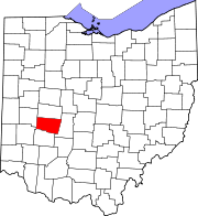
Location in the state of Ohio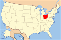
Ohio's location in the U.S.Founded March 1, 1818[1] Named for General George Rogers Clark Seat Springfield Largest city Springfield Area
- Total
- Land
- Water
403 sq mi (1,045 km²)
400 sq mi (1,036 km²)
4 sq mi (10 km²), 0.92%Population
- (2000)
- Density
144,742
362/sq mi (140/km²)Time zone Eastern: UTC-5/-4 Website www.clarkcountyohio.gov Clark County is a county located in the state of Ohio, United States. As of 2010, the population was 133,333.[2] It is included in the Springfield, Ohio Metropolitan Statistical Area.
The county was created on March 1, 1818, and was named for General George Rogers Clark, a hero of the American Revolution.[3] Its county seat is Springfield[4].
Contents
Geography
According to the U.S. Census Bureau, the county has a total area of 1,045 square kilometers (403 sq mi). 1,036 km2 (400 sq mi) of it is land and 10 km2 (4 sq mi) of it (0.92%) is water.
Adjacent counties
- Champaign County (north)
- Madison County (east)
- Greene County (south)
- Montgomery County (southwest)
- Miami County (west)
Demographics
Historical populations Census Pop. %± 1820 9,533 — 1830 13,114 37.6% 1840 16,882 28.7% 1850 22,178 31.4% 1860 25,300 14.1% 1870 32,070 26.8% 1880 41,948 30.8% 1890 52,277 24.6% 1900 58,939 12.7% 1910 66,435 12.7% 1920 80,728 21.5% 1930 90,936 12.6% 1940 95,647 5.2% 1950 111,661 16.7% 1960 131,440 17.7% 1970 157,115 19.5% 1980 150,236 −4.4% 1990 147,548 −1.8% 2000 144,742 −1.9% 2010 133,333 −7.9% As of the census[5] of 2000, there were 144,742 people, 56,648 households, and 39,370 families residing in the county. The population density was 362 people per square mile (140/km²). There were 61,056 housing units at an average density of 153 per square mile (59/km²). The racial makeup of the county was 88.12% White, 8.95% Black or African American, 0.28% Native American, 0.53% Asian, 0.02% Pacific Islander, 0.53% from other races, and 1.58% from two or more races. 1.17% of the population were Hispanic or Latino of any race. 23.8% were of German, 21.6% American, 10.4% Irish and 8.7% English ancestry according to Census 2000.
There were 56,648 households out of which 31.40% had children under the age of 18 living with them, 52.60% were married couples living together, 12.80% had a female householder with no husband present, and 30.50% were non-families. 26.00% of all households were made up of individuals and 11.10% had someone living alone who was 65 years of age or older. The average household size was 2.49 and the average family size was 2.97.
In the county the population was spread out with 25.10% under the age of 18, 9.10% from 18 to 24, 26.80% from 25 to 44, 24.30% from 45 to 64, and 14.70% who were 65 years of age or older. The median age was 38 years. For every 100 females there were 92.50 males. For every 100 females age 18 and over, there were 88.60 males.
The median income for a household in the county was $40,340, and the median income for a family was $48,259. Males had a median income of $37,157 versus $24,688 for females. The per capita income for the county was $19,501. About 7.90% of families and 10.70% of the population were below the poverty line, including 14.90% of those under age 18 and 8.20% of those age 65 or over.
Springfield MSA
Clark County is coterminous with the Springfield, Ohio Metropolitan Statistical Area.
History
The Springfield metropolitan area was first defined in 1950. Then known as the Springfield Standard Metropolitan Area (Springfield SMA), it consisted of a single county – Clark – and had a population of 111,661.[6][7] Following a term change by the Bureau of the Budget (present-day Office of Management and Budget) in 1959, the Springfield SMA became the Springfield Standard Metropolitan Statistical Area (Springfield SMSA).[8] By the census of 1960, the population had grown to 131,440, a 18 percent increase over the previous census.[7] Champaign County was added to the Springfield SMSA in 1973. The two-county area had a combined population of 187,606 in 1970.[7]
In 1983, the official name was shortened to the Springfield Metropolitan Statistical Area (Springfield MSA).[8] That same year, Dayton and Springfield were grouped together as the Dayton-Springfield Metropolitan Statistical Area. The new MSA consisted of four counties – Clark, Greene, Miami, and Montgomery.[9] This arrangement remained unchanged until 2003, when the MSA was split with Springfield's newly defined metropolitan area including only Clark County.[10]
Government
Communities
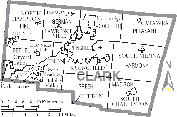
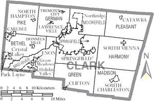 Map of Clark County, Ohio With Municipal and Township Labels
Cities
Villages
Townships
Census-designated places
Other communities
Education
Public School Districts
- Clark - Shawnee Local School District
- Shawnee High School, Springfield (the Braves)
- Greenon Local School District
- Greenon High School, Springfield (the Knights)
- Northeastern Local School District
- Kenton Ridge High School, Springfield (the Cougars)
- Northeastern High School , Springfield (the Jets)
- Northwestern Local School District
- Northwestern High School, Springfield (the Warriors)
- Southeastern Local Schools
- Southeastern High School, South Charleston (the Trojans)
- Springfield City School District
- Springfield City High School, (the Wildcats)]
- Tecumseh Local School District
- Tecumseh High School, New Carlisle (the Arrows)
See also
- Clark County Public Library
- Clark County Heritage Center
- National Register of Historic Places listings in Clark County, Ohio
References
- ^ "Ohio County Profiles: Clark County" (PDF). Ohio Department of Development. http://www.odod.state.oh.us/research/FILES/S0/Clark.pdf. Retrieved 2007-04-28.
- ^ "American FactFinder2". http://factfinder2.census.gov/faces/nav/jsf/pages/index.xhtml. Retrieved 2010-03-20.
- ^ "Clark County data". Ohio State University Extension Data Center. http://www.osuedc.org/profiles/profile_entrance.php?fips=39023&sid=0. Retrieved 2007-04-28.[dead link]
- ^ "Find a County". National Association of Counties. http://www.naco.org/Counties/Pages/FindACounty.aspx. Retrieved 2011-06-07.
- ^ "American FactFinder". United States Census Bureau. http://factfinder.census.gov. Retrieved 2008-01-31.
- ^ "Standard Metropolitan Areas (SMAs) and Components" (TXT). Standard Metropolitan Areas defined by the Bureau of the Budget, October 13, 1950. United States Census Bureau, Population Division. 2000-12-14. http://www.census.gov/population/www/metroareas/lists/historical/50mfips.txt. Retrieved 2009-02-07.
- ^ a b c "Ohio - Population of Counties by Decennial Census: 1900 to 1990". United States Census Bureau, Population Division. 1995-03-27. http://www.census.gov/population/www/censusdata/cencounts/files/oh190090.txt. Retrieved 2009-02-07.
- ^ a b "About Metropolitan and Micropolitan Statistical Areas". United States Census Bureau, Population Division. http://www.census.gov/population/www/metroareas/aboutmetro.html. Retrieved 2009-02-07.
- ^ "Metropolitan Areas and Components, 1983" (TXT). Metropolitan Areas defined by Office of Management and Budget, June 27, 1983. United States Census Bureau, Population Division. 2001-03-01. http://www.census.gov/population/www/metroareas/lists/historical/83mfips.txt. Retrieved 2009-02-07.
- ^ "Metropolitan Statistical Areas and Components, 2003" (TXT). Metropolitan statistical areas defined by Office of Management and Budget, June 6, 2003. United States Census Bureau, Population Division. 2003-07-10. http://www.census.gov/population/www/metroareas/lists/2003/03msa.txt. Retrieved 2009-02-07.
External links

Champaign County Miami County 
Madison County  Clark County, Ohio

Montgomery County Greene County Municipalities and communities of Clark County, Ohio Cities 
Villages Catawba | Clifton‡ | Donnelsville | Enon | North Hampton | South Charleston | South Vienna | Tremont City
Townships Bethel | German | Green | Harmony | Mad River | Madison | Moorefield | Pike | Pleasant | Springfield
CDPs Unincorporated
communitiesFootnotes ‡This populated place also has portions in an adjacent county or counties
Categories:- Ohio counties
- Clark County, Ohio
- 1818 establishments in the United States
- Populated places established in 1818


Wikimedia Foundation. 2010.