- Ohio census statistical areas
-
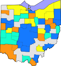 Map of Ohio census statistical areas
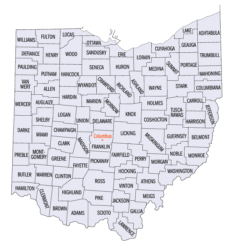
 Map of the 88 counties of the State of Ohio
The United States Census Bureau has defined 9 Combined Statistical Areas (CSAs),[1] 16 Metropolitan Statistical Areas (MSAs),[2] and 29 Micropolitan Statistical Areas (μSAs)[3] in the State of Ohio. The following table describes these areas with the following information:
- The name of the Combined Statistical Area (CSA), if any.[1][4]
- The population of the CSA as of 2010-07-01, as estimated by the United States Census Bureau.[5][6]
- The name of the Core Based Statistical Area (CBSA).[7][4]
- The population of the CBSA as of 2010-07-01, as estimated by the United States Census Bureau.[8][6]
- The name of the county.[4]
- The population of the county as of 2010-07-01, as estimated by the United States Census Bureau.[9][6]
United States Census Bureau Statistical Areas in the State of Ohio Combined Statistical Area 2010 Pop Core Based Statistical Area 2010 Pop County 2010 Pop Cleveland-Akron-Elyria, OH CSA 2,881,937 Cleveland-Elyria-Mentor, OH MSA 2,077,240 Cuyahoga County, Ohio 1,280,122 Lorain County, Ohio 301,356 Lake County, Ohio 232,892 Medina County, Ohio 172,332 Geauga County, Ohio 95,676 Akron, OH MSA 703,200 Summit County, Ohio 541,781 Portage County, Ohio 161,419 Ashtabula, OH μSA 100,767 Ashtabula County, Ohio 100,767 Columbus-Marion-Chillicothe, OH CSA 2,071,052 Columbus, OH MSA 1,836,536 Franklin County, Ohio 1,163,414 Delaware County, Ohio 165,026 Licking County, Ohio 156,287 Fairfield County, Ohio 141,318 Pickaway County, Ohio 53,606 Union County, Ohio 46,702 Madison County, Ohio 41,496 Morrow County, Ohio 34,520 Chillicothe, OH μSA 75,972 Ross County, Ohio 75,972 Marion, OH μSA 65,655 Marion County, Ohio 65,655 Mount Vernon, OH μSA 59,637 Knox County, Ohio 59,637 Washington Court House, OH μSA 28,117 Fayette County, Ohio 28,117 Cincinnati-Middletown-Wilmington, OH-KY-IN CSA 2,172,191
1,667,023Cincinnati-Middletown, OH-KY-IN MSA 2,130,151
1,624,983Hamilton County, Ohio 802,374 Butler County, Ohio 368,130 Warren County, Ohio 212,693 Clermont County, Ohio 197,363 Kenton County, Kentucky 159,720 Boone County, Kentucky 118,811 Campbell County, Kentucky 90,336 Dearborn County, Indiana 50,047 Brown County, Ohio 44,423 Grant County, Kentucky 24,769 Franklin County, Indiana 23,087 Pendleton County, Kentucky 15,334 Bracken County, Kentucky 8,488 Gallatin County, Kentucky 8,153 Ohio County, Indiana 6,128 Wilmington, OH μSA 42,040 Clinton County, Ohio 42,040 Dayton-Springfield-Greenville, OH CSA 1,072,891 Dayton, OH MSA 841,502 Montgomery County, Ohio 535,153 Greene County, Ohio 161,573 Miami County, Ohio 102,506 Preble County, Ohio 42,270 Springfield, OH MSA 133,333 Clark County, Ohio 133,333 Greenville, OH μSA 51,814 Darke County, Ohio 51,814 Urbana, OH μSA 39,713 Champaign County, Ohio 39,713 Toledo-Fremont, OH CSA 712,373 Toledo, OH MSA 651,429 Lucas County, Ohio 441,815 Wood County, Ohio 125,399 Fulton County, Ohio 42,562 Ottawa County, Ohio 41,084 Fremont, OH μSA 60,944 Sandusky County, Ohio 60,944 Youngstown-Warren-East Liverpool, OH-PA CSA 673,614
556,976Youngstown-Warren-Boardman, OH-PA MSA 565,773
449,135Mahoning County, Ohio 240,420 Trumbull County, Ohio 213,475 Mercer County, Pennsylvania 116,638 East Liverpool-Salem, OH μSA 107,841 Columbiana County, Ohio 107,841 primary census statistical area 404,422 Canton-Massillon, OH MSA 404,422 Stark County, Ohio 378,664 Carroll County, Ohio 28,836 Lima-Van Wert-Wapakoneta, OH CSA 181,024 Lima, OH MSA 106,331 Allen County, Ohio 106,331 Wapakoneta, OH μSA 46,699 Auglaize County, Ohio 46,699 Van Wert, OH μSA 28,496 Van Wert County, Ohio 28,496 Mansfield-Bucyrus, OH CSA 168,259 Mansfield, OH MSA 124,475 Richland County, Ohio 124,475 Bucyrus, OH μSA 43,403 Crawford County, Ohio 43,403 Findlay-Tiffin, OH CSA 131,527 Findlay, OH μSA 74,538 Hancock County, Ohio 74,538 Tiffin, OH μSA 56,152 Seneca County, Ohio 56,152 primary census statistical area 113,950 Wooster, OH μSA 113,950 Wayne County, Ohio 113,950 primary census statistical area 91,766 New Philadelphia-Dover, OH μSA 91,766 Tuscarawas County, Ohio 91,766 primary census statistical area 86,125 Zanesville, OH μSA 86,125 Muskingum County, Ohio 86,125 primary census statistical area 78,116 Sandusky, OH MSA 78,116 Erie County, Ohio 78,116 primary census statistical area 76,441 Portsmouth, OH μSA 76,441 Scioto County, Ohio 76,441 primary census statistical area 125,168
70,125Weirton-Steubenville, WV-OH MSA 125,168
70,125Jefferson County, Ohio 70,125 Hancock County, West Virginia 30,911 Brooke County, West Virginia 24,132 primary census statistical area 147,329
68,771Wheeling, WV-OH MSA 147,329
68,771Belmont County, Ohio 68,771 Ohio County, West Virginia 44,662 Marshall County, West Virginia 33,896 primary census statistical area 285,475
63,179Huntington-Ashland, WV-KY-OH MSA 285,475
63,179Cabell County, West Virginia 93,904 Lawrence County, Ohio 63,179 Boyd County, Kentucky 49,371 Wayne County, West Virginia 41,647 Greenup County, Kentucky 37,374 primary census statistical area 161,724
61,867Parkersburg-Marietta-Vienna, WV-OH MSA 161,724
61,867Wood County, West Virginia 86,597 Washington County, Ohio 61,867 Pleasants County, West Virginia 7,280 Wirt County, West Virginia 5,980 primary census statistical area 61,860 Athens, OH μSA 61,860 Athens County, Ohio 61,860 primary census statistical area 60,313 Norwalk, OH μSA 60,313 Huron County, Ohio 60,313 primary census statistical area 54,727 Ashland, OH μSA 54,727 Ashland County, Ohio 54,727 primary census statistical area 48,884 Sidney, OH μSA 48,884 Shelby County, Ohio 48,884 primary census statistical area 46,189 Bellefontaine, OH μSA 46,189 Logan County, Ohio 46,189 primary census statistical area 41,303 Celina, OH μSA 41,303 Mercer County, Ohio 41,303 primary census statistical area 40,876 Cambridge, OH μSA 40,876 Guernsey County, Ohio 40,876 primary census statistical area 39,091 Defiance, OH μSA 39,091 Defiance County, Ohio 39,091 primary census statistical area 36,976 Coshocton, OH μSA 36,976 Coshocton County, Ohio 36,976 primary census statistical area 57,069
31,313Point Pleasant, WV-OH μSA 57,069
31,313Gallia County, Ohio 31,313 Mason County, West Virginia 25,756 none Highland County, Ohio 42,833 Holmes County, Ohio 41,574 Williams County, Ohio 38,719 Perry County, Ohio 35,313 Putnam County, Ohio 34,744 Jackson County, Ohio 33,543 Hardin County, Ohio 31,966 Henry County, Ohio 29,520 Hocking County, Ohio 28,973 Adams County, Ohio 28,516 Pike County, Ohio 28,269 Meigs County, Ohio 23,092 Wyandot County, Ohio 22,553 Paulding County, Ohio 19,432 Harrison County, Ohio 15,799 Morgan County, Ohio 14,821 Monroe County, Ohio 14,606 Noble County, Ohio 14,165 Vinton County, Ohio 13,519 See also
 United States census statistical areas by state, district, or territoryOHASMPGUVI
- State of Ohio
- Demographics of Ohio
- Geography of Ohio
- United States
References
- ^ a b The United States Census Bureau defines a Combined Statistical Area (CSA) as an aggregate of adjacent Core Based Statistical Areas that are linked by commuting ties.
- ^ The United States Census Bureau defines a Metropolitan Statistical Area (MSA) as a Core Based Statistical Area having at least one urbanized area of 50,000 or more population, plus adjacent territory that has a high degree of social and economic integration with the core as measured by commuting ties.
- ^ The United States Census Bureau defines a Micropolitan Statistical Area (μSA) as a Core Based Statistical Area having at least one urban cluster of at least 10,000 but less than 50,000 population, plus adjacent territory that has a high degree of social and economic integration with the core as measured by commuting ties.
- ^ a b c An area that extends into more than one state is displayed in teal. An out-of-state area is displayed in green.
- ^ "Annual Estimates of the Population of Combined Statistical Areas: April 1, 2000 to July 1, 2006 (CBSA-EST2006-02)" (CSV). 2006 Population Estimates. United States Census Bureau, Population Division. 2007-04-05. http://www.census.gov/population/www/estimates/metro_general/2006/CBSA-EST2006-02.csv. Retrieved 2007-04-09.
- ^ a b c The total population of a multi-state area is displayed in teal, with the in-state population displayed below in black. The population of an out-of-state area is displayed in green.
- ^ The United States Census Bureau defines a Core Based Statistical Area (CBSA) as one or more adjacent counties or county equivalents that have at least one urban cluster of at least 10,000 population, plus adjacent territory that has a high degree of social and economic integration with the core as measured by commuting ties. The Census Bureau has defined two types of CBSAs: (1) a Metropolitan Statistical Area (MSA), which has an urban core population of 50,000 or more, or (2) a Micropolitan Statistical Area (μSA), which has an urban core population of 10,000 or more but less than 50,000.
- ^ "Annual Estimates of the Population of Metropolitan and Micropolitan Statistical Areas: April 1, 2000 to July 1, 2006 (CBSA-EST2006-01)" (CSV). 2006 Population Estimates. United States Census Bureau, Population Division. 2007-04-05. http://www.census.gov/population/www/estimates/metro_general/2006/CBSA-EST2006-01.csv. Retrieved 2007-04-09.
- ^ "Annual County Population Estimates and Estimated Components of Change: April 1, 2000 to July 1, 2006 (CO-EST2006-alldata)" (CSV). 2006 Population Estimates. United States Census Bureau, Population Division. 2007-03-22. http://www.census.gov/popest/counties/files/CO-EST2006-ALLDATA.csv. Retrieved 2007-04-09.
External links
Categories:- Metropolitan areas of Ohio
- Micropolitan areas of Ohio
- Census statistical areas
- Ohio-related lists

Wikimedia Foundation. 2010.