Missouri census statistical areas

Missouri census statistical areas

The United States Census Bureau has defined 3 Combined Statistical Areas (CSAs),[1] 8 Metropolitan Statistical Areas (MSAs),[2] and 20 Micropolitan Statistical Areas (μSAs)[3] in the State of Missouri. The following table describes these areas with the following information:

  • The name of the Combined Statistical Area (CSA), if any.[1][4]
  • The population of the CSA as of 2008-07-01, as estimated by the United States Census Bureau.[5][6]
  • The name of the Core Based Statistical Area (CBSA).[7][4]
  • The population of the CBSA as of 2008-07-01, as estimated by the United States Census Bureau.[8][6]
  • The name of the county or independent city.[4]
  • The population of the county or independent city as of 2008-07-01, as estimated by the United States Census Bureau.[9][6]
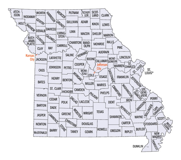
Map of the 114 counties and 1 independent city of the State of Missouri
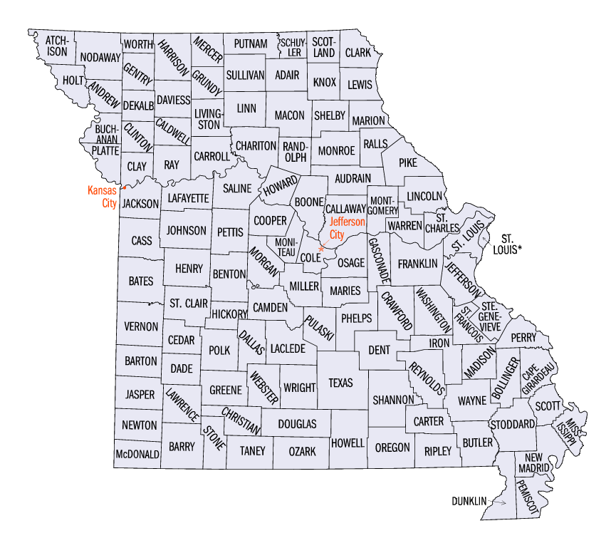

United States Census Bureau Statistical Areas in the State of Missouri
Combined Statistical Area 2008 Pop Core Based Statistical Area 2008 Pop County 2008 Pop
St. Louis-St. Charles-Farmington, MO-IL CSA 2,879,924
2,185,926
St. Louis, MO-IL MSA 2,816,710
2,122,712
St. Louis County, Missouri 991,830
St. Louis City 354,361
St. Charles County, Missouri 360,485
Madison County, Illinois 267,038
St. Clair County, Illinois 261,409
Jefferson County, Missouri 217,679
Franklin County, Missouri 100,898
Lincoln County, Missouri 52,775
Macoupin County, Illinois 48,143
Clinton County, Illinois 36,470
Monroe County, Illinois 32,335
Warren County, Missouri 31,214
Washington County, Missouri 24,548
Jersey County, Illinois 22,451
Bond County, Illinois 18,253
Calhoun County, Illinois 5,101
Farmington, MO μSA 63,214 St. Francois County, Missouri 63,214
Kansas City-Overland Park-Kansas City, MO-KS CSA 2,059,328
1,224,240
Kansas City, MO-KS MSA 1,990,831
1,172,224
Jackson County, Missouri 668,417
Johnson County, Kansas 524,723
Clay County, Missouri 215,707
Wyandotte County, Kansas 153,698
Cass County, Missouri 98,429
Platte County, Missouri 85,896
Leavenworth County, Kansas 73,438
Lafayette County, Missouri 32,913
Miami County, Kansas 30,710
Franklin County, Kansas 26,422
Ray County, Missouri 23,445
Clinton County, Missouri 21,094
Bates County, Missouri 17,075
Linn County, Kansas 9,616
Caldwell County, Missouri 9,248
Warrensburg, MO μSA 52,016 Johnson County, Missouri 52,016
Atchison, KS μSA 16,481 Atchison County, Kansas 16,481
primary census statistical area 426,144 Springfield, MO MSA 426,144 Greene County, Missouri 266,944
Christian County, Missouri 75,479
Webster County, Missouri 36,473
Polk County, Missouri 30,404
Dallas County, Missouri 16,844
primary census statistical area 172,933 Joplin, MO MSA 172,933 Jasper County, Missouri 116,813
Newton County, Missouri 56,120
primary census statistical area 164,283 Columbia, MO MSA 164,283 Boone County, Missouri 154,365
Howard County, Missouri 9,918
primary census statistical area 146,363 Jefferson City, MO MSA 146,363 Cole County, Missouri 74,313
Callaway County, Missouri 43,464
Moniteau County, Missouri 15,121
Osage County, Missouri 13,465
Cape Girardeau-Sikeston-Jackson, MO-IL CSA 134,058
125,906
Cape Girardeau-Jackson, MO-IL μSA 93,385
85,233
Cape Girardeau County, Missouri 73,243
Bollinger County, Missouri 11,990
Alexander County, Illinois 8,152
Sikeston, MO μSA 40,673 Scott County, Missouri 40,673
primary census statistical area 126,359
118,606
St. Joseph, MO-KS MSA 126,359
118,606
Buchanan County, Missouri 89,408
Andrew County, Missouri 16,923
DeKalb County, Missouri 12,275
Doniphan County, Kansas 7,753
primary census statistical area 78,574 Branson, MO μSA 78,574 Taney County, Missouri 47,023
Stone County, Missouri 31,551
primary census statistical area 44,546 Fort Leonard Wood, MO μSA 44,546 Pulaski County, Missouri 44,546
primary census statistical area 42,205 Rolla, MO μSA 42,205 Phelps County, Missouri 42,205
primary census statistical area 41,383 Poplar Bluff, MO μSA 41,383 Butler County, Missouri 41,383
primary census statistical area 41,006 Sedalia, MO μSA 41,006 Pettis County, Missouri 41,006
primary census statistical area 39,000 West Plains, MO μSA 39,000 Howell County, Missouri 39,000
primary census statistical area 38,057 Hannibal, MO μSA 38,057 Marion County, Missouri 28,225
Ralls County, Missouri 9,832
primary census statistical area 35,524 Lebanon, MO μSA 35,524 Laclede County, Missouri 35,524
primary census statistical area 31,454 Kennett, MO μSA 31,454 Dunklin County, Missouri 31,454
primary census statistical area 29,053 Kirksville, MO μSA 29,053 Adair County, Missouri 24,943
Schuyler County, Missouri 4,110
primary census statistical area 26,049 Mexico, MO μSA 26,049 Audrain County, Missouri 26,049
primary census statistical area 25,723 Moberly, MO μSA 25,723 Randolph County, Missouri 25,723
primary census statistical area 433,890
22,731
Fayetteville-Springdale-Rogers, AR-MO MSA 433,890
22,731
Benton County, Arkansas 202,363
Washington County, Arkansas 193,145
McDonald County, Missouri 22,731
Madison County, Arkansas 15,651
primary census statistical area 22,505 Marshall, MO μSA 22,505 Saline County, Missouri 22,505
primary census statistical area 22,054 Maryville, MO μSA 22,054 Nodaway County, Missouri 22,054
primary census statistical area 76,817
9,951
Quincy, IL-MO μSA 76,817
9,951
Adams County, Illinois 66,866
Lewis County, Missouri 9,951
primary census statistical area 42,844
7,180
Fort Madison-Keokuk, IA-MO μSA 42,844
7,180
Lee County, Iowa 35,664
Clark County, Missouri 7,180
none Camden County, Missouri 40,664
Lawrence County, Missouri 37,757
Barry County, Missouri 36,301
Stoddard County, Missouri 29,537
Miller County, Missouri 24,949
Texas County, Missouri 24,598
Crawford County, Missouri 23,970
Henry County, Missouri 22,179
Morgan County, Missouri 20,861
Vernon County, Missouri 20,009
Perry County, Missouri 18,743
Pemiscot County, Missouri 18,515
Pike County, Missouri 18,476
Wright County, Missouri 18,443
Benton County, Missouri 18,349
Ste. Genevieve County, Missouri 17,720
New Madrid County, Missouri 17,589
Cooper County, Missouri 17,535
Macon County, Missouri 15,621
Gasconade County, Missouri 15,261
Dent County, Missouri 15,199
Livingston County, Missouri 14,213
Cedar County, Missouri 13,652
Mississippi County, Missouri 13,504
Ripley County, Missouri 13,485
Douglas County, Missouri 13,438
Wayne County, Missouri 12,652
Barton County, Missouri 12,531
Linn County, Missouri 12,580
Madison County, Missouri 12,276
Montgomery County, Missouri 11,804
Oregon County, Missouri 10,264
Grundy County, Missouri 10,125
Iron County, Missouri 9,918
Carroll County, Missouri 9,756
St. Clair County, Missouri 9,270
Ozark County, Missouri 9,227
Monroe County, Missouri 9,127
Hickory County, Missouri 9,048
Maries County, Missouri 9,046
Harrison County, Missouri 8,844
Shannon County, Missouri 8,423
Daviess County, Missouri 7,911
Chariton County, Missouri 7,740
Dade County, Missouri 7,418
Sullivan County, Missouri 6,629
Shelby County, Missouri 6,411
Reynolds County, Missouri 6,388
Gentry County, Missouri 6,185
Atchison County, Missouri 6,031
Carter County, Missouri 5,890
Holt County, Missouri 4,905
Putnam County, Missouri 4,862
Scotland County, Missouri 4,798
Knox County, Missouri 4,020
Mercer County, Missouri 3,523
Worth County, Missouri 2,039

See also

United States census statistical areas by state, district, or territory
MO
AS
MP
GU
VI

References

  1. ^ a b The United States Census Bureau defines a Combined Statistical Area (CSA) as an aggregate of adjacent Core Based Statistical Areas that are linked by commuting ties.
  2. ^ The United States Census Bureau defines a Metropolitan Statistical Area (MSA) as a Core Based Statistical Area having at least one urbanized area of 50,000 or more population, plus adjacent territory that has a high degree of social and economic integration with the core as measured by commuting ties.
  3. ^ The United States Census Bureau defines a Micropolitan Statistical Area (μSA) as a Core Based Statistical Area having at least one urban cluster of at least 10,000 but less than 50,000 population, plus adjacent territory that has a high degree of social and economic integration with the core as measured by commuting ties.
  4. ^ a b c An area that extends into more than one state is displayed in teal. An out-of-state area is displayed in green.
  5. ^ "Annual Estimates of the Population of Combined Statistical Areas: April 1, 2000 to July 1, 2008 (CBSA-EST2008-02)" (CSV). 2008 Population Estimates. United States Census Bureau, Population Division. 2009-04-05. http://www.census.gov/population/www/estimates/metro_general/2008/CBSA-EST2008-02.csv. Retrieved 2009-11-21. 
  6. ^ a b c The total population of a multi-state area is displayed in teal, with the in-state population displayed below in black. The population of an out-of-state area is displayed in green.
  7. ^ The United States Census Bureau defines a Core Based Statistical Area (CBSA) as one or more adjacent counties or county equivalents that have at least one urban cluster of at least 10,000 population, plus adjacent territory that has a high degree of social and economic integration with the core as measured by commuting ties. The Census Bureau has defined two types of CBSAs: (1) a Metropolitan Statistical Area (MSA), which has an urban core population of 50,000 or more, or (2) a Micropolitan Statistical Area (μSA), which has an urban core population of 10,000 or more but less than 50,000.
  8. ^ "Annual Estimates of the Population of Metropolitan and Micropolitan Statistical Areas: April 1, 2000 to July 1, 2008 (CBSA-EST2008-01)" (CSV). 2008 Population Estimates. United States Census Bureau, Population Division. 2009-04-05. http://www.census.gov/population/www/estimates/metro_general/2008/CBSA-EST2008-01.csv. Retrieved 2009-11-21. 
  9. ^ "Annual County Population Estimates and Estimated Components of Change: April 1, 2000 to July 1, 2008 (CO-EST2008-alldata)" (CSV). 2008 Population Estimates. United States Census Bureau, Population Division. 2009-03-22. http://www.census.gov/popest/counties/files/CO-EST2008-ALLDATA.csv. Retrieved 2009-11-21. 

External links


Wikimedia Foundation. 2010.

Игры ⚽ Поможем написать курсовую

Look at other dictionaries:

  • North Dakota census statistical areas — The United States Census Bureau has defined one Combined Statistical Area (CSA),[1] three Metropolitan Statistical Areas (MSAs),[2] and five Micropolitan Statistical Areas (μSAs)[3] in the State of North Dakota. The following table describes… …   Wikipedia

  • Highest-income metropolitan statistical areas in the United States — Income in the United States Affluence in the United States Household income in the United States Income inequality in the United States Personal income in the United States Social class in the United States Income by: State (localities by state)… …   Wikipedia

  • St. Joseph, Missouri Metropolitan Area — The St. Joseph Metropolitan Statistical Area, as defined by the United States Census Bureau, is an area consisting of four counties three in northwest Missouri (Andrew, Buchanan, and DeKalb) and one in northeast Kansas (Doniphan) anchored by the… …   Wikipedia

  • Jefferson County, Missouri — Seal …   Wikipedia

  • List of Missouri-related topics — The following is a list of topics about the U.S. State of Missouri. NOTOC compactTOC4 0–9*24th State to join the United States of AmericaA*Adjacent states: **Commonwealth of Kentucky **State of Arkansas **State of Illinois **State of Iowa **State …   Wikipedia

  • Columbia, Missouri Metropolitan Area — Columbia Common name: Columbia Metropolitan Area Largest city Columbia Other cities   …   Wikipedia

  • Joplin, Missouri Metropolitan Area — The Joplin Metropolitan Statistical Area, as defined by the United States Census Bureau, is an area consisting of two counties ndash; Jasper and Newton ndash; in southwest Missouri, anchored by the city of Joplin. As of the 2000 census, the MSA… …   Wikipedia

  • Jackson County, Missouri — Location in the state of Missouri …   Wikipedia

  • Jefferson City, Missouri Metropolitan Area — The Jefferson City Metropolitan Statistical Area, as defined by the United States Census Bureau, is an area consisting of four counties ndash; Cole, Callaway, Moniteau, and Osage ndash; in central Missouri anchored by the city of Jefferson City.… …   Wikipedia

  • Clay County, Missouri — Location in the state of Missouri …   Wikipedia

Share the article and excerpts

Direct link
Do a right-click on the link above
and select “Copy Link”