North Carolina census statistical areas

North Carolina census statistical areas

The United States Census Bureau has defined 5 Combined Statistical Areas (CSAs),[1] 15 Metropolitan Statistical Areas (MSAs),[2] and 26 Micropolitan Statistical Areas (μSAs)[3] in the State of North Carolina. The following table describes these areas with the following information:

  • The name of the Combined Statistical Area (CSA).[1][4]
  • The population of the CSA as of 2009-07-01, as estimated by the United States Census Bureau.[5][6]
  • The name of the Core Based Statistical Area (CBSA).[7][4]
  • The population of the CBSA as of 2009-07-01, as estimated by the United States Census Bureau.[8][6]
  • The name of the county or independent city.[4]
  • The population of the county or independent city as of 2009-07-01, as estimated by the United States Census Bureau.[9][6]


United States Census Bureau Statistical Areas in the State of North Carolina
Combined Statistical Area 2009 Pop Core Based Statistical Area 2009 Pop County 2009 Pop
Charlotte-Gastonia-Salisbury, NC-SC CSA 2,389,763 Charlotte-Gastonia-Concord, NC-SC MSA 1,745,524 Mecklenburg County, North Carolina 913,639
Gaston County, North Carolina 208,958
York County, South Carolina 227,003
Union County, North Carolina 198,645
Cabarrus County, North Carolina 172,223
Anson County, North Carolina 25,056
Statesville-Mooresville, NC μSA 158,153 Iredell County, North Carolina 158,153
Salisbury, NC μSA 140,798 Rowan County, North Carolina 140,798
Shelby, NC μSA 99,274 Cleveland County, North Carolina 99,274
Lincolnton, NC μSA 76,043 Lincoln County, North Carolina 76,043
Lancaster, SC μSA 77,767 Lancaster County, South Carolina 77,767
Albemarle, NC μSA 59,794 Stanly County, North Carolina 59,794
Chester, SC μSA 32,410 Chester County, South Carolina 32,410
Raleigh-Durham-Cary, NC CSA 1,742,816 Raleigh-Cary, NC MSA 1,125,827 Wake County, North Carolina 897,214
Johnston County, North Carolina 168,525
Franklin County, North Carolina 60,088
Durham, NC MSA 501,228 Durham County, North Carolina 269,706
Orange County, North Carolina 129,083
Chatham County, North Carolina 64,772
Person County, North Carolina 37,667
Dunn, NC μSA 115,761 Harnett County, North Carolina 115,761
Greensboro-Winston-Salem-High Point, NC CSA 1,581,122 Greensboro-High Point, NC MSA 714,765 Guilford County, North Carolina 480,362
Randolph County, North Carolina 142,151
Rockingham County, North Carolina 92,252
Winston-Salem, NC MSA 484,921 Forsyth County, North Carolina 359,638
Stokes County, North Carolina 46,150
Davie County, North Carolina 41,420
Yadkin County, North Carolina 37,713
Thomasville-Lexington, NC μSA 158,582 Davidson County, North Carolina 158,582
Burlington, NC MSA 150,358 Alamance County, North Carolina 150,358
Mount Airy, NC μSA 72,496 Surry County, North Carolina 72,496
Asheville-Brevard, NC CSA 427,789 Asheville, NC MSA 412,672 Buncombe County, North Carolina 231,452
Henderson County, North Carolina 103,669
Haywood County, North Carolina 57,109
Madison County, North Carolina 20,442
Brevard, NC μSA 30,203 Transylvania County, North Carolina 30,203
primary census statistical area 365,364 Hickory-Lenoir-Morganton, NC MSA 365,364 Catawba County, North Carolina 159,125
Burke County, North Carolina 89,548
Caldwell County, North Carolina 79,914
Alexander County, North Carolina 36,777
primary census statistical area 360,355 Fayetteville, NC MSA 360,355 Cumberland County, North Carolina 315,207
Hoke County, North Carolina 45,148
primary census statistical area 354,525 Wilmington, NC MSA 354,525 New Hanover County, North Carolina 195,085
Brunswick County, North Carolina 107,062
Pender County, North Carolina 52,378
Lumberton-Laurinburg, NC CSA 166,115 Lumberton, NC μSA 129,559 Robeson County, North Carolina 129,559
Laurinburg, NC μSA 36,292 Scotland County, North Carolina 36,292
primary census statistical area 179,715 Greenville, NC MSA 179,715 Pitt County, North Carolina 159,057
Greene County, North Carolina 20,658
primary census statistical area 150,673 Jacksonville, NC MSA 173,064 Onslow County, North Carolina 173,064
primary census statistical area 146,596 Rocky Mount, NC MSA 146,596 Nash County, North Carolina 94,743
Edgecombe County, North Carolina 51,853
primary census statistical area 121,022 New Bern, NC μSA 121,022 Craven County, North Carolina 98,529
Pamlico County, North Carolina 12,422
Jones County, North Carolina 10,071
primary census statistical area 113,847 Goldsboro, NC MSA 113,811 Wayne County, North Carolina 113,811
primary census statistical area 83,162 Southern Pines-Pinehurst, NC μSA 83,162 Moore County, North Carolina 87,158
primary census statistical area 74,718 Roanoke Rapids, NC μSA 74,718 Halifax County, North Carolina 54,582
Northampton County, North Carolina 20,136
primary census statistical area 76,624 Wilson, NC μSA 78,353 Wilson County, North Carolina 78,353
primary census statistical area 66,555 North Wilkesboro, NC μSA 66,555 Wilkes County, North Carolina 66,555
primary census statistical area 63,415 Forest City, NC μSA 63,415 Rutherford County, North Carolina 63,415
primary census statistical area 64,423 Morehead City, NC μSA 64,423 Carteret County, North Carolina 64,423
primary census statistical area 64,042 Elizabeth City, NC μSA 64,042 Pasquotank County, North Carolina 41,578
Perquimans County, North Carolina 12,734
Camden County, North Carolina 9,730
primary census statistical area 57,662 Kinston, NC μSA 56,387 Lenoir County, North Carolina 56,387
primary census statistical area 60,477 Sanford, NC μSA 60,477 Lee County, North Carolina 60,477
primary census statistical area 45,970 Rockingham, NC μSA 45,970 Richmond County, North Carolina 45,970
primary census statistical area 46,414 Washington, NC μSA 46,414 Beaufort County, North Carolina 46,414
primary census statistical area 43,056 Henderson, NC μSA 43,056 Vance County, North Carolina 43,056
primary census statistical area 45,479 Boone, NC μSA 45,479 Watauga County, North Carolina 45,479
primary census statistical area 34,296 Kill Devil Hills, NC μSA 34,296 Dare County, North Carolina 34,296
primary census statistical area 1,676,542
24,216
Virginia Beach-Norfolk-Newport News, VA-NC MSA 1,676,542
24,216
City of Virginia Beach, Virginia 435,619
City of Norfolk, Virginia 233,333
City of Chesapeake, Virginia 222,455
City of Newport News, Virginia 193,172
City of Hampton, Virginia 144,236
City of Portsmouth, Virginia 99,321
City of Suffolk, Virginia 83,659
York County, Virginia 61,140
James City County, Virginia 63,735
Gloucester County, Virginia 39,184
Isle of Wight County, Virginia 35,877
Currituck County, North Carolina 24,216
City of Poquoson, Virginia 11,794
City of Williamsburg, Virginia 12,729
Mathews County, Virginia 8,984
Surry County, Virginia 7,088
none Sampson County, North Carolina 63,713
Columbus County, North Carolina 54,221
Granville County, North Carolina 57,639
Duplin County, North Carolina 53,177
McDowell County, North Carolina 43,988
Jackson County, North Carolina 36,891
Bladen County, North Carolina 32,343
Macon County, North Carolina 33,233
Montgomery County, North Carolina 27,745
Cherokee County, North Carolina 26,307
Ashe County, North Carolina 25,812
Martin County, North Carolina 23,337
Hertford County, North Carolina 23,283
Caswell County, North Carolina 23,004
Warren County, North Carolina 19,425
Polk County, North Carolina 19,255
Bertie County, North Carolina 19,345
Yancey County, North Carolina 18,548
Avery County, North Carolina 17,932
Mitchell County, North Carolina 15,634
Chowan County, North Carolina 14,784
Swain County, North Carolina 13,404
Washington County, North Carolina 12,851
Gates County, North Carolina 11,768
Alleghany County, North Carolina 10,964
Clay County, North Carolina 10,333
Graham County, North Carolina 8,001
Hyde County, North Carolina 5,211
Tyrrell County, North Carolina 4,078
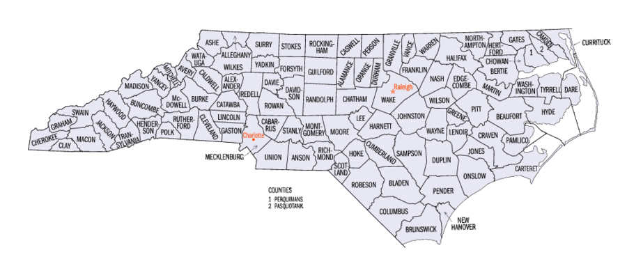
Map of the 100 counties of the State of North Carolina


See also

United States census statistical areas by state, district, or territory
NC
AS
MP
GU
VI

References

  1. ^ a b The United States Census Bureau defines a Combined Statistical Area (CSA) as an aggregate of adjacent Core Based Statistical Areas that are linked by commuting ties.
  2. ^ The United States Census Bureau defines a Metropolitan Statistical Area (MSA) as a Core Based Statistical Area having at least one urbanized area of 50,000 or more population, plus adjacent territory that has a high degree of social and economic integration with the core as measured by commuting ties.
  3. ^ The United States Census Bureau defines a Micropolitan Statistical Area (μSA) as a Core Based Statistical Area having at least one urban cluster of at least 10,000 but less than 50,000 population, plus adjacent territory that has a high degree of social and economic integration with the core as measured by commuting ties.
  4. ^ a b c An area that extends into more than one state is displayed in teal. An out-of-state area is displayed in green.
  5. ^ "Annual Estimates of the Population of Combined Statistical Areas: April 1, 2000 to July 1, 2006 (CBSA-EST2006-02)" (CSV). 2006 Population Estimates. United States Census Bureau, Population Division. 2007-04-05. http://www.census.gov/population/www/estimates/metro_general/2006/CBSA-EST2006-02.csv. Retrieved 2007-04-08. 
  6. ^ a b c The total population of a multi-state area is displayed in teal, with the in-state population displayed below in black. The population of an out-of-state area is displayed in green.
  7. ^ The United States Census Bureau defines a Core Based Statistical Area (CBSA) as one or more adjacent counties or county equivalents that have at least one urban cluster of at least 10,000 population, plus adjacent territory that has a high degree of social and economic integration with the core as measured by commuting ties. The Census Bureau has defined two types of CBSAs: (1) a Metropolitan Statistical Area (MSA), which has an urban core population of 50,000 or more, or (2) a Micropolitan Statistical Area (μSA), which has an urban core population of 10,000 or more but less than 50,000.
  8. ^ "Annual Estimates of the Population of Metropolitan and Micropolitan Statistical Areas: April 1, 2000 to July 1, 2009 (CBSA-EST2006-01)" (CSV). 2006 Population Estimates. United States Census Bureau, Population Division. 2007-04-05. http://www.census.gov/population/www/estimates/metro_general/2006/CBSA-EST2006-01.csv. Retrieved 2007-04-08. 
  9. ^ "Annual County Population Estimates and Estimated Components of Change: April 1, 2000 to July 1, 2006 (CO-EST2006-alldata)" (CSV). 2006 Population Estimates. United States Census Bureau, Population Division. 2007-03-22. http://www.census.gov/popest/counties/files/CO-EST2006-ALLDATA.csv. Retrieved 2007-04-08. 

External links


Wikimedia Foundation. 2010.

Игры ⚽ Поможем написать реферат

Look at other dictionaries:

  • Index of North Carolina-related articles — Location of the State of North Carolina in the United States of America Main article: North Carolina See also: Outline of North Carolina Articles about the U.S. State of North Carolina include: Co …   Wikipedia

  • List of North Carolina-related topics — The following is a list of topics about the U.S. State of North Carolina. NOTOC compactTOC4 0–9*12th State to ratify the Constitution of the United States of AmericaA [ 100 counties of the State of North Carolina] *Adjacent states: **Commonwealth …   Wikipedia

  • Fayetteville, North Carolina metropolitan area — The Fayetteville Metropolitan Statistical Area, as defined by the United States Census Bureau, is an area consisting of two counties ndash; Cumberland and Hoke ndash; in eastern North Carolina, anchored by the city of Fayetteville. As of the 2000 …   Wikipedia

  • Greenville, North Carolina metropolitan area — The Greenville Metropolitan Statistical Area, as defined by the United States Census Bureau, is an area consisting of two counties ndash; Pitt and Greene ndash; in eastern North Carolina, anchored by the city of Greenville. As of the 2000 census …   Wikipedia

  • Jacksonville, North Carolina metropolitan area — The Jacksonville Metropolitan Statistical Area, as defined by the United States Census Bureau, is an area consisting of one county ndash; Onslow ndash; in North Carolina, anchored by the city of Jacksonville. As of the 2000 census, the MSA had a… …   Wikipedia

  • North Wilkesboro Micropolitan Area — The North Wilkesboro Micropolitan Statistical Area, as defined by the United States Census Bureau, is a populated area consisting of the whole of Wilkes County, North Carolina, anchored by the town of North Wilkesboro.[1][2] Demographics As of… …   Wikipedia

  • Chapel Hill, North Carolina — Coordinates: 35°56′N 79°2′W / 35.933°N 79.033°W / 35.933; 79.033 …   Wikipedia

  • Alamance County, North Carolina — Infobox U.S. County county = Alamance County state = North Carolina map size = 250 founded = 1849 seat = Graham | area total sq mi =435 area land sq mi =430 area water sq mi =5 area percentage = 1.10% census yr = 2007 pop = 145360 density km2… …   Wikipedia

  • Onslow County, North Carolina — The 1904 Onslow County Courthouse …   Wikipedia

  • Burlington, North Carolina — City of Burlington   City   Seal Nickname(s) …   Wikipedia

Share the article and excerpts

Direct link
Do a right-click on the link above
and select “Copy Link”