- Jackson County, North Carolina
-
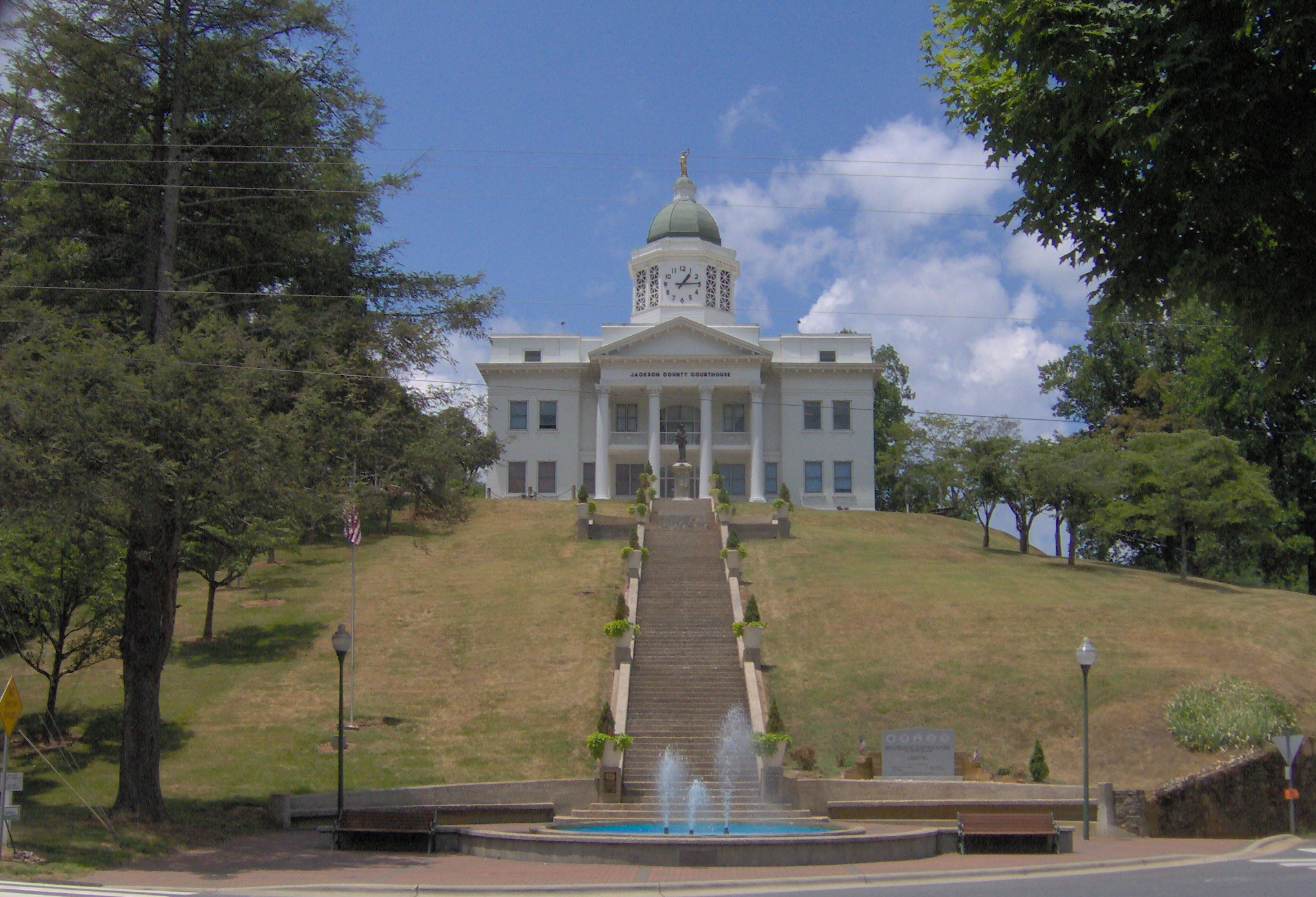
Jackson County, North Carolina 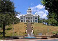 Old Jackson County Courthouse in downtown Sylva
Seal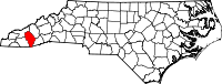
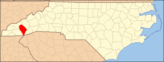
Location in the state of North Carolina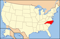
North Carolina's location in the U.S.Founded 1851 Seat Sylva Area
- Total
- Land
- Water
494 sq mi (1,279 km²)
490 sq mi (1,269 km²)
4 sq mi (10 km²), 0.77%Population
- (2010)
- Density
40,271
67/sq mi (26/km²)Website www.jacksonnc.org Jackson County is a county located in the southwest of the U.S. state of North Carolina. As of 2010, the population was 40,271. Since 1913 its county seat has been Sylva,[1] replacing Webster.
Contents
History
The county was formed in 1851 from parts of Haywood County and Macon County. It was named for Andrew Jackson, President of the United States from 1829 to 1837. The original county courts were held at the Dan Bryson home in the community of Beta in Scott Creek township, and moved to Webster the following year.
In 1861 parts of Jackson County and Henderson County were combined to form Transylvania County. In 1871 parts of Jackson County and Macon County were combined to form Swain County. In 1913 Sylva became the county seat.
Law and government
Jackson County is a member of the regional Southwestern Commission council of governments.
Jackson County contains a portion of the Qualla Boundary, a tribal reservation for the Eastern Band of Cherokee Indians, which is subject mostly to tribal/federal laws rather than county or state laws.
Geography
According to the U.S. Census Bureau, the county has a total area of 494 square miles (1,279.5 km2), of which 491 square miles (1,271.7 km2) is land and 4 square miles (10.4 km2) (0.77%) is water.
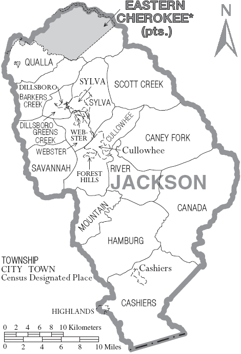
Townships
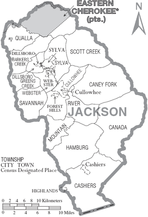
The county is divided into fifteen townships:
Barker's Creek: Named for the creek which originates and flows through the township before entering the Tuckasegee River. It includes the Dicks Creek, Barkers Creek, and Wilmont communities, and US 74/23 runs as a four-lane divided highway through the township. It is served by Smokey Mountain Elementary School and Smoky Mountain High School. Formerly, the Log Cabin Association Consolidated School served the township, but it closed when Smokey Mountain Elementary opened in 1980.
Canada: Named for the tall ridges, narrow valleys, and sharp peaks of this part of the county, the main waterway is the East Fork of the Tuckasegee River which flows into the River Township before joining the West Fork, becoming the Tuckasegee River. There are four major lakes, Bear, Wolf, Tanasee Creek, and Ceader Cliff, in the township. It is served by NC 281 and is one of the most remote locations in the county. It is served by Cullowhee Valley School and Smoky Mountain High School. Before the 1990s, the schools for the area were Canada Consolidated School and Cullowhee High School, both closed in the 1980s.
Caney Fork: Named for the creek that flows through the township, Caney Fork, which empties into the Tuckasegee River at East LaPorte. The main road is Caney Fork Road, and the area is served by Cullowhee Valley School and Smoky Mountain High School. Prior to 1964 the schools that served the area were Johns Creek Elementary and Cullowhee High School.
Cashiers: Named for a lost horse, the town of Cashiers is located here, as well as the communities of Panthertown Valley, Whiteside Cove, Fairfield, and Sapphire. It is served by NC 107 and US 64. The Eastern Continental Divide follows a ridge north of the township, and defines the boundaries between the Cashiers, Canada, and Glenville townships. The Chattooga, Horsepasture, and Toxaway rivers all originate or flow through the township. It is served by Blue Ridge School, which consolidated Glenville School and Cashiers Elementary in 1975.
Cullowhee: The Cherokee name for the valley was corrupted from its original name into Cullowhee, the original meaning either "Valley of the Lilies" or "Valley of the Buzzards." The valley of the lilies nickname is more commonly referred to. NC 107, Old NC 107, and NC 107-Alternate all serve the township as major roads, though NC 107 is the only 4-lane roadway. Western Carolina University, the village of Forest Hills, and the communities of Speedwell, Old Cullowhee Road, Buzzards Roost, and Dicks Gap are all within the township. It was one of the first areas in the county to be settled by the whites, along with Caney Fork, River, Scott Creek, and Canada townships. It is the largest township population-wise according to the 2000 United States Census. The Tuckasegee River and Cullowhee Creek both flow through the township, with the latter emptying into the former around Old Cullowhee Road. It is served by Cullowhee Valley School, located in the township, and Smoky Mountain High School in Sylva. Formerly, there was Cullowhee High School, but it closed in 1988.
Dillsboro: Named after the Dills Family who founded the town, the township is home to the town of Dillsboro. To the northwest of Dillsboro, Scotts Creek, which flows from Scott Creek Township through Sylva Township into Dillsboro Township, empties into the Tuckasegee River. US 74/23, US 441, and NC 107 all converge in two major intersections within the township. The township is served by Smokey Mountain and Fairview elementary schools and by Smoky Mountain High School. It hasn't had its own school since Dillsboro Elementary closed in 1951. The students were then transferred to Log Cabin School in Barkers Creek Township or Sylva Elementary School in Sylva township.
Greens Creek: Named for the creek which flows through most of the township before emptying into Savannah Creek, Greens Creek Township is served by US 441, in the form of a four-lane highway along the western edge. Greens Creek Road goes through the middle of the township. It is served by Fairview Elementary School and Smokey Mountain Elementary School, as well as Smoky Mountain High School. It was formerly served by the Savannah Consolidated School, which opened in 1940 and closed in 1973.
Hamburg: Named for the fort and original name of Glenville, the township is served by NC 107. The area was once a large valley, but the valley was flooded in 1941 to form Lake Glenville. The West Fork of the Tuckasegee River originates within the township, and flows north into the River Township. Blue Ridge School is located in the township and serves the township. It originated from the consolidation of the Glenville School and Cashiers Elementary School in 1975.
Mountain: Named for Cullowhee Mountain which it resides on, the Mountain Township is served by NC 107 Alternate. The headwaters of Cullowhee Creek are located here, flowing north into Cullowhee Township before joining the Tuckasegee River. It is served by Cullowhee Valley School/Smoky Mountain High School, and was formerly served by Cullowhee High School and Camp Lab Elementary.
Qualla: Named for the Qualla Boundary which takes up a lion's share portion of the township, Qualla Township is served by US 441, US 19, and US 74/23. Smokey Mountain Elementary School is located in the township, resulting from the 1980 consolidation of Qualla Elementary School and Log Cabin Association Consolidated School. It is served by the Jackson County Public School System and the Cherokee Reservation School System. Students can choose to either go to Smokey Mountain Elementary/Smoky Mountain High School, Cherokee School, or Swain East Elementary, Swain Middle School and Swain High School. The communities of Qualla, Birdtown, Soco, Whittier, Indian Hills, and Wilmont are all located at least partially, if not wholly, within the township.
River: Named for the Tuckasegee River, which converges from two streams into one within the township, it is served by NC 107 and NC 281. The community of Tuckasegee is located in the township. It is served by Cullowhee Valley School/Smoky Mountain High School, and, prior to 1958, Tuckasegee School and Cullowhee High School.
Savannah: Named for Savannah Creek, which runs through the district, Savannah Township is home to the Viewpoint, Pumpkintown, Savannah, and Fort Wilderness communities. The township is served by four-lane US 441. Fairview Elementary School and Smoky Mountain High School serve the township as well. It was home to Savannah Consolidated School, which fed into Webster High School and later Sylva-Webster High School, from 1940 until 1973.
Scotts Creek: Named for Scotts Creek, which begins and flows through the township before running into Sylva Township. It is served by US 74/23 and old US 19/23, which run through the five communities within the township, Balsam, Willets, Ochre Hill, Addie, and Beta. The Murphy Branch Railroad also runs through the township. Scotts Creek School has served the township since 1951, and had a new building constructed in 2001.
Sylva: Named for William D. Sylva, as is the town of Sylva, located within the township, which is served by NC 107, US 74/23, and BUS 23. The Jackson County Courthouse and Library are both located in the township. Scotts Creek runs through the township before emptying into Dillsboro Township. The township is served by Fairview and Scotts Creek elementary schools and Smoky Mountain High School. Formerly, students in the township would have gone to Sylva Elementary/Sylva High School, and later Sylva-Webster High School, but consolidation has closed many smaller schools in the county.
Webster: The location of the town of Webster, Webster Township sits at the original geographical center of the county, which has moved to Cullowhee Township due to land taken away for the formation of Swain and Transylvania counties. It was for many years home to the only town in Jackson County. It is served by NC 116 and NC 107. The county seat designation and courthouse were located here from 1851 to 1913, but the county seat subsequently moved to Sylva. The township once was home to Webster Elementary School (1936–1973) and Webster High School (1936–1960), but now the schools that serve the township are Fairview Elementary School (1973) and Smoky Mountain High School (1960/1988).
Adjacent counties
- Haywood County, North Carolina - northeast
- Transylvania County, North Carolina - east
- Oconee County, South Carolina - south
- Macon County, North Carolina - west
- Swain County, North Carolina - northwest

Swain County Haywood County Macon County 
Transylvania County  Jackson County, North Carolina

Oconee County, South Carolina National protected areas
- Blue Ridge Parkway (part)
- Nantahala National Forest (part)
Demographics
As of the census[2] of 2010, there were 40,271 people. As of the 2000 Census, there were 13,191 households and 8,587 families residing in the county. The population density was 68 people per square mile (26/km²). There were 19,291 housing units at an average density of 39 per square mile (15/km²). The racial makeup of the county was 85.68% White, 1.67% Black or African American, 10.20% Native American, 0.51% Asian, 0.02% Pacific Islander, 0.55% from other races, and 1.38% from two or more races. 1.74% of the population were Hispanic or Latino of any race. 18.5% were of American, 13.7% English, 11.3% Irish, 10.5% German and 9.2% Scots-Irish ancestry according to Census 2000. 95.3% spoke English, 2.1% Spanish and 1.5% Cherokee as their first language.
There were 13,191 households out of which 25.50% had children under the age of 18 living with them, 51.40% were married couples living together, 10.00% had a female householder with no husband present, and 34.90% were non-families. 27.00% of all households were made up of individuals and 9.80% had someone living alone who was 65 years of age or older. The average household size was 2.30 and the average family size was 2.79.
In the county the population was spread out with 19.00% under the age of 18, 17.90% from 18 to 24, 24.40% from 25 to 44, 25.00% from 45 to 64, and 13.80% who were 65 years of age or older. The median age was 36 years. For every 100 females there were 95.40 males. For every 100 females age 18 and over, there were 93.10 males.
The median income for a household in the county was $32,552, and the median income for a family was $40,876. Males had a median income of $27,738 versus $22,029 for females. The per capita income for the county was $17,582. About 9.50% of families and 15.10% of the population were below the poverty line, including 15.70% of those under age 18 and 15.20% of those age 65 or over.
Cities and towns
 Map of Jackson County, North Carolina With Municipal and Township Labels
- Balsam (unincorporated, Scott Creek township)
- Cashiers (unincorporated, Cashiers township)
- Cullowhee (unincorporated, Cullowhee township)
- Dillsboro (incorporated town, Dillsboro township)
- Forest Hills ("village")
- Glenville (unincorporated, Hamburg township)
- Highlands (10% of incorporated town, Cashiers township)
- Savannah (unincorporated)
- Sylva (incorporated town, Sylva township)
- Webster (incorporated town, Webster township)
Transportation
Roads and highways
Jackson County is served by three main roads: the Great Smoky Mountains Expressway runs east-west across the northern half of the county and connects the county seat of Sylva to Waynesville and Asheville in the east and Cherokee, Andrews and Murphy in the west. North Carolina State Highway 107 connects Sylva and Western Carolina University to Cashiers in the south. U.S. Highway 64 traverses east-west across the southern part of the county connecting Cashiers to Brevard in the east and Highlands in the west.
Railroads
Norfolk Southern Railway operates a portion the Murphy Branch through Jackson County, providing a rail connection with the rest of the country. In Sylva, Norfolk Southern connects with the Great Smoky Mountains Railroad. Interchange between the two lines is handled near Jackson Paper Company. Great Smoky Mountains Railroad operates the rest of the Murphy Branch from Dillsboro to Andrews.
Airports
The county contains one airport, the Jackson County Airport located one mile (1.6 km) east of Cullowhee.
Churches
Buff Creek Baptist Church is located just outside of Sylva. It is a small, conservative church with a family atmosphere.
Grace Community Church is a new church with casual, contemporary worship that meets at the Sylva Inn. Rich Peoples is the church's pastor.
Dick's Creek is a road and community just west of Dillsboro off of Highway 74 in Jackson County. Just over 1.5 miles (2.4 km) up the road on the right is historic Dick's Creek Baptist Church built in 1903. Until 1946 this church was used as both a church and school. As of 2009, services are still held.
LifeWay Community Church is located in the heart of downtown Sylva. A non-denominational church, LifeWay meets weekly on Sunday mornings at their main campus and has small group meetings on Wednesday evenings throughout Jackson and Swain counties.
Popular culture
Several movies have been filmed in the county including the 1993 blockbuster action-adventure The Fugitive starring Harrison Ford and Tommy Lee Jones, the 1972 drama Deliverance, and the 1996 comedy My Fellow Americans starring Jack Lemmon and James Garner.
- The train wreck scene in The Fugitive was filmed in Dillsboro along the Great Smoky Mountains Railroad. The wreckage set can still be viewed on outbound train excursions from Dillsboro. The later scene in a small hospital was filmed at Harris Regional Hospital in Sylva.
- The Great Smoky Mountains Railroad was also used in the filming of My Fellow Americans when they stumble on to a charter train full of UNC-Chapel Hill fans headed for the NCAA Final Four.
- The back side of downtown Sylva was used for a short driving scene in the filming of Deliverance.
- Ron Rash's 2008 novel, "Serena," features Jackson County.
See also
- Blue Ridge Parkway
- Cherokee
- Chattooga River
- Great Smoky Mountains
- Great Smoky Mountains Expressway
- Great Smoky Mountains National Park
- Horsepasture River
- Jackson County Courthouse
- National Register of Historic Places listings in Jackson County, North Carolina
- Qualla Boundary
- Toxaway River
- Tuckasegee River
- Western Carolina University
References
- ^ "Find a County". National Association of Counties. http://www.naco.org/Counties/Pages/FindACounty.aspx. Retrieved 2011-06-07.
- ^ "American FactFinder". United States Census Bureau. http://factfinder.census.gov. Retrieved 2008-01-31.
External links
- Jackson County official website
- The Sylva Herald
- Jackson County Rescue Squad
- Jackson County Travel & Tourism
Coordinates: 35°17′N 83°08′W / 35.29°N 83.14°W
Municipalities and communities of Jackson County, North Carolina Towns 
Village CDPs Unincorporated
communitiesFootnotes ‡This populated place also has portions in an adjacent county or counties
Categories:- North Carolina counties
- 1852 establishments in the United States
- Jackson County, North Carolina


Wikimedia Foundation. 2010.