- Onslow County, North Carolina
-
Onslow County, North Carolina 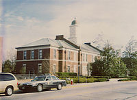 The 1904 Onslow County Courthouse
Seal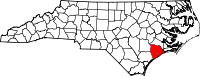
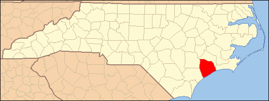
Location in the state of North Carolina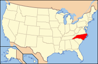
North Carolina's location in the U.S.Founded 1734 Seat Jacksonville Area
- Total
- Land
- Water
909 sq mi (2,354 km²)
767 sq mi (1,987 km²)
142 sq mi (368 km²), 15.60%PopulationEst.
- (2009)
- Density
173,064
197/sq mi (76/km²)Website www.co.onslow.nc.us Onslow County is a county located in the U.S. state of North Carolina. It is included in the Jacksonville, North Carolina, Metropolitan Statistical Area. As of 2006, the population was 150,673.[1] Its county seat is Jacksonville[2].
Contents
Law and government
The structure of local government in Onslow County was established in the late 19th century and consists of a five-member Board of Commissioners, elected at large for four-year terms. The Board establishes policies and ordinances implemented by the County Manager and his staff. Commissioners are, W.C. Jarman, Chairman, Paul Buchanan, Vice-Chairman, Barbara M. Ikner, William H. Keller III, and Lionell Midgett.
The main law enforcement agency for Onslow County is the Onslow County Sheriff's Department. The elected sheriff is Sheriff Edward Brown.
Onslow County is a member of the regional Eastern Carolina Council of Governments.
History
European and English settlers arrived here in 1713 in what was originally part of the colonial precincts of Carteret and New Hanover. Onslow County was formed in 1734 and was named for the Honorable Arthur Onslow, Speaker of the British House of Commons. After a lethal 1752 hurricane, the county courthouse was relocated from Town Point to Wantland’s Ferry; this settlement was eventually incorporated in 1842 and named Jacksonville after President Andrew Jackson. Largely a collection of sparsely populated agrarian and maritime communities, Onslow County dramatically changed in the early 1940s with the establishment of the United States Army Camp Davis near Holly Ridge (now defunct), and the creation of Camp Lejeune in 1941.
Onslow County’s flat, rolling terrain covers 767 square miles (1,990 km2) and is located in the southeastern coastal plain of North Carolina, approximately 120 miles (190 km) east of Raleigh and 50 miles (80 km) north of Wilmington. The city of Jacksonville is the county seat, and the areas surrounding the city constitute the major population centers and growth areas in the county. The county is home to more than 150,000 people and includes the incorporated towns of Holly Ridge, Richlands, Swansboro, North Topsail Beach, part of Surf City, and unincorporated Sneads Ferry. Approximately 156,000 acres (630 km2) comprise the U.S. Marine Corps Base, Camp Lejeune and more than 43,000 marines and sailors are stationed there.
The structure of local government in Onslow County was established in the late 19th century and consists of a five-member Board of Commissioners, elected at large for four-year terms. The Board establishes policies and ordinances implemented by the County Manager and his staff. Commissioners are, W.C. Jarman, Chairman, Paul Buchanan, Vice-Chairman, Barbara M. Ikner, William H. Keller III, and Lionell Midgett.
Geography
According to the U.S. Census Bureau, the county has a total area of 909 square miles (2,350 km2), of which, 767 square miles (1,990 km2) of it is land and 142 square miles (370 km2) of it (15.60%) is water.
Major highways and airport
- US Highway 17
- US Highway 258
- NC Highway 24
The Albert J. Ellis Airport is located near Richlands and is served by two commercial airlines.
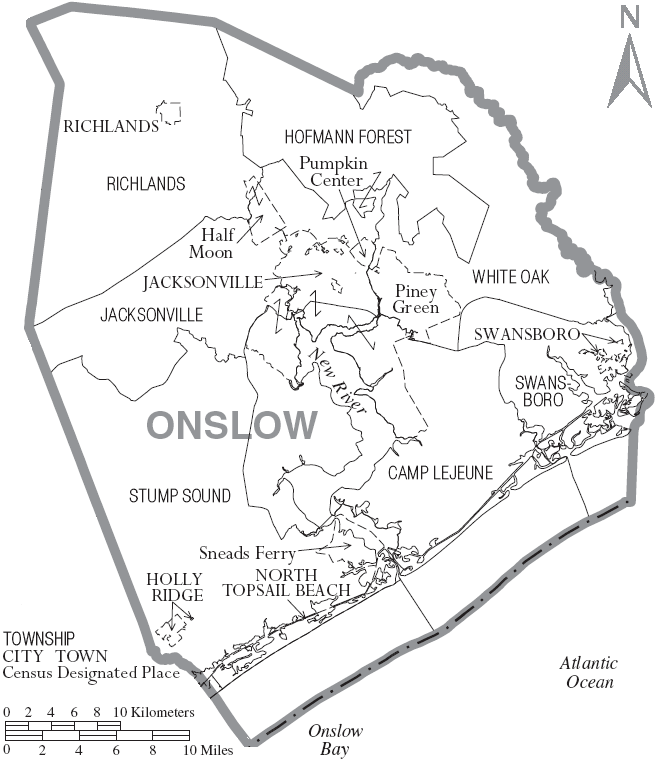
Townships
The county is divided into five townships: Jacksonville, Richlands, Sneads Ferry, Swansboro, and White Oak.
Adjacent counties
- Jones County, North Carolina - north
- Carteret County, North Carolina - east
- Pender County, North Carolina - southwest
- Duplin County, North Carolina - northwest

Duplin County Jones County 
Carteret County  Onslow County, North Carolina

Pender County Atlantic Ocean Demographics
Historical Populations Census Pop. %± 1900 11,940 — 1910 14,125 18.3% 1920 14,703 4.1% 1930 15,289 4.0% 1940 17,939 17.3% 1950 42,047 134.4% 1960 82,706 96.7% 1970 103,126 24.7% 1980 112,784 9.4% 1990 149,838 32.9% 2000 150,355 0.3% Est. 2006 150,673 [3] 0.2% As of the census[4] of 2000, there were 150,355 people, 48,122 households, and 36,572 families residing in the county. The population density was 196 people per square mile (76/km²). There were 55,726 housing units at an average density of 73 per square mile (28/km²). The racial makeup of the county was 72.06% White, 18.48% Black or African American, 0.74% Native American, 1.68% Asian, 0.19% Pacific Islander, 3.62% from other races, and 3.22% from two or more races. 7.25% of the population were Hispanic or Latino of any race.
There were 48,122 households out of which 42.60% had children under the age of 18 living with them, 61.00% were married couples living together, 11.60% had a female householder with no husband present, and 24.00% were non-families. 18.60% of all households were made up of individuals and 5.20% had someone living alone who was 65 years of age or older. The average household size was 2.72 and the average family size was 3.09.
In the county the population was spread out with 26.20% under the age of 18, 23.80% from 18 to 24, 29.20% from 25 to 44, 14.40% from 45 to 64, and 6.30% who were 65 years of age or older. The median age was 25 years. For every 100 females there were 123.20 males. For every 100 females age 18 and over, there were 131.30 males.
The median income for a household in the county was $33,756, and the median income for a family was $36,692. Males had a median income of $22,061 versus $20,094 for females. The per capita income for the county was $14,853. About 10.80% of families and 12.90% of the population were below the poverty line, including 16.70% of those under age 18 and 14.70% of those age 65 or over.
Cities and towns
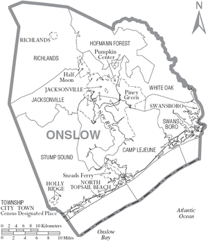 Map of Onslow County, North Carolina With Municipal and Township Labels
- Half Moon
- Holly Ridge
- Jacksonville
- North Topsail Beach
- Piney Green
- Pumpkin Center
- Richlands
- Sneads Ferry
- Swansboro
See also
References
- ^ Onslow County QuickFacts from the US Census Bureau
- ^ "Find a County". National Association of Counties. http://www.naco.org/Counties/Pages/FindACounty.aspx. Retrieved 2011-06-07.
- ^ "Onslow County QuickFacts". U.S. Census Bureau. http://quickfacts.census.gov/qfd/states/37/37133.html. Retrieved 2007-10-01.
- ^ "American FactFinder". United States Census Bureau. http://factfinder.census.gov. Retrieved 2008-01-31.
External links
- Onslow County Government official website
- Onslow County Schools
- Onslow County Museum
- DineOnslow.com - Website dedicated to restaurants in Onslow County
Municipalities and communities of Onslow County, North Carolina City 
Towns CDPs Unincorporated
communitiesHubert | Montclair | Petersburg
Military bases Footnotes ‡This populated place also has portions in an adjacent county or counties
Places Carteret County · Onslow County
Beaufort · Morehead City · Atlantic Beach · Pine Knoll Shores · Salter Path · Indian Beach · Emerald Isle · Cape Carteret · Cedar Point · SwansboroWaterways Protected areas Transportation Categories:- North Carolina counties
- Crystal Coast
- Onslow County, North Carolina
- States and territories established in 1734


Wikimedia Foundation. 2010.