- Lumberton, North Carolina
Infobox Settlement
official_name = Lumberton, North Carolina
settlement_type =City
nickname =
motto =
imagesize =
image_caption = A view down Elm Street in Lumberton from
"the square"
image_
mapsize = 250x200px
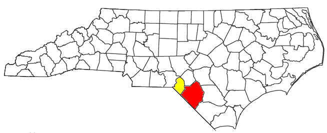
map_caption = Location of Lumberton, North Carolina
mapsize1 =
map_caption1 =subdivision_type = Country
subdivision_name =United States
subdivision_type1 = State
subdivision_name1 =North Carolina
subdivision_type2 = County
subdivision_name2 = Robeson
government_footnotes =
government_type =
leader_title =
leader_name =
leader_title1 =
leader_name1 =
established_title =
established_date =unit_pref = Imperial
area_footnotes =area_magnitude =
area_total_km2 = 40.9
area_land_km2 = 40.7
area_water_km2 = 0.2
area_total_sq_mi = 15.8
area_land_sq_mi = 15.7
area_water_sq_mi = 0.1population_as_of = 2000
population_footnotes =
population_total = 20795
population_density_km2 = 510.6
population_density_sq_mi = 1322.4timezone = Eastern (EST)
utc_offset = -5
timezone_DST = EDT
utc_offset_DST = -4
elevation_footnotes =
elevation_m = 40
elevation_ft = 131
latd = 34 |latm = 37 |lats = 38 |latNS = N
longd = 79 |longm = 0 |longs = 43 |longEW = Wpostal_code_type =
ZIP code s
postal_code = 28358-28360
area_code = 910
blank_name = FIPS code
blank_info = 37-39700GR|2
blank1_name = GNIS feature ID
blank1_info = 0989128GR|3
website = [http://www.ci.lumberton.nc.us/ www.ci.lumberton.nc.us]
footnotes =Lumberton is a city in Robeson County,
North Carolina ,United States . The population was 20,795 at the 2000 census. It is thecounty seat of Robeson County.GR|6 Lumberton, located in southern North Carolina'sInner Banks region, is located on theLumber River . Founded in1787 byJohn Willis , an officer in theAmerican Revolution , Lumberton was originally a shipping point forlumber used by the Navy, which was sent downriver to Georgetown,South Carolina . Most of the town's growth, however, began shortly afterWorld War II .History
The City of Lumberton was created by an Act of the
North Carolina General Assembly in 1787 and was named the County seat ofRobeson County .Lumberton was founded the same year that thirty-nine of the fifty-five delegates to the Constitutional Convention of
Philadelphia signed and sent to Congress theConstitution of the United States .Robeson County is located in the Coastal Plains region of southeasternNorth Carolina . The County was created fromBladen County in 1786 by twoAmerican Revolutionary War heroes and residents of the area, GeneralJohn Willis and ColonelThomas Robeson . The county was named after ColonelThomas Robeson and the land for the County seat was donated by General Willis who is also accredited with naming the County seat Lumberton. Lumberton was incorporated in 1859.Throughout most of the 20th century, local financial services were provided to citizens of Lumberton, Fayetteville, and Spring Lake by
Home Federal Savings and Loan Association . This long-time Fayetteville establishment was purchased byNew South Bank in the 1990s, which later becameFirst South Bank .David Lynch 's1986 film "Blue Velvet " was set in Lumberton, though it was actually filmed in nearby Wilmington. This situation raised some problems during filming, so Lynch filmed a small sequence in Lumberton and was subsequently allowed to use the name.On
July 23 ,1993 ,James R. Jordan, Sr. , father ofbasketball legendMichael Jordan , was murdered at a rest stop off of Interstate 95 near Lumberton.Alice Faye Williams, a.k.a
Afeni Shakur ; a prominent member of theBlack Panther Party and more famously, the mother of the rapperTupac Shakur , was born in Lumberton onJanuary 10 ,1947 .Dr.
Johnny Hunt , who was elected president of theSouthern Baptist Convention in 2008, was born in Lumberton.Geography
Lumberton is located at coor dms|34|37|38|N|79|0|43|W|city (34.627239, -79.011947).GR|1
According to the
United States Census Bureau , the city has a total area of 15.8square mile s (40.9km² ).15.7 square miles (40.7 km²) of it is land and 0.1 square miles (0.2 km²) of it (0.44%) is water.Lumberton is located on the
Lumber River in the coastal plains region ofNorth Carolina . TheLumber River State Park , one hundred and fifteen miles of natural and scenicwaterway , flows through Lumberton.Lumber River was designated as a National Wild and Scenic River and is part of the North Carolina Natural and Scenic River System. The River has been classified as natural, scenic, and recreational and is considered one of the most highly prized recreation sites in North Carolina. Recreation includescanoeing andboating ,fishing ,hunting , picnicking,camping , nature study,swimming ,biking ,jogging ,crafts andfossil and artifact hunting.Demographics
thumb|left|300px|Location of the Lumberton-Laurinburg CSA and its components:Lumberton is the larger principal city of the Lumberton-Laurinburg CSA, a
Combined Statistical Area that includes the Lumberton (Robeson County) and Laurinburg (Scotland County micropolitan areas, [ [http://www.census.gov/population/www/estimates/metro_general/2006/List5.txt MICROPOLITAN STATISTICAL AREAS AND COMPONENTS] ,Office of Management and Budget ,2007-05-11 . Accessed2008-08-01 .] [ [http://www.census.gov/population/www/estimates/metro_general/2006/List6.txt COMBINED STATISTICAL AREAS AND COMPONENT CORE BASED STATISTICAL AREAS] ,Office of Management and Budget ,2007-05-11 . Accessed2008-08-01 .] which had a combined population of 159,337 at the 2000 census.GR|2As of the
census GR|2 of 2000, there were 20,795 people, 7,827 households, and 5,165 families residing in the city. Thepopulation density was 1,322.4 people per square mile (510.8/km²). There were 8,800 housing units at an average density of 559.6/sq mi (216.1/km²). The racial makeup of the city was 48.54% White, 35.44% African American, 12.79% Native American, 0.91% Asian, 0.03% Pacific Islander, 1.18% from other races, and 1.11% from two or more races. Hispanic or Latino of any race were 3.30% of the population.There were 7,827 households out of which 32.2% had children under the age of 18 living with them, 38.8% were married couples living together, 23.0% had a female householder with no husband present, and 34.0% were non-families. 29.9% of all households were made up of individuals and 12.6% had someone living alone who was 65 years of age or older. The average household size was 2.44 and the average family size was 3.01.
In the city the population was spread out with 26.3% under the age of 18, 9.3% from 18 to 24, 28.2% from 25 to 44, 21.3% from 45 to 64, and 14.8% who were 65 years of age or older. The median age was 35 years. For every 100 females there were 89.1 males. For every 100 females age 18 and over, there were 85.8 males.
The median income for a household in the city was $26,782, and the median income for a family was $33,839. Males had a median income of $28,903 versus $24,503 for females. The
per capita income for the city was $15,504. About 23.9% of families and 25.9% of the population were below thepoverty line , including 38.4% of those under age 18 and 23.7% of those age 65 or over.References
External links
* [http://www.ci.lumberton.nc.us/ Official website of Lumberton, NC]
* [http://www.lumbertonchamber.com/ Lumberton Area Chamber of Commerce]
* [http://www.lumbertontimes.com/ Online News for Lumberton (www.lumbertontimes.com)]
Wikimedia Foundation. 2010.