- Waynesville, North Carolina
Infobox Settlement
official_name = Waynesville, North Carolina
settlement_type =Town
motto =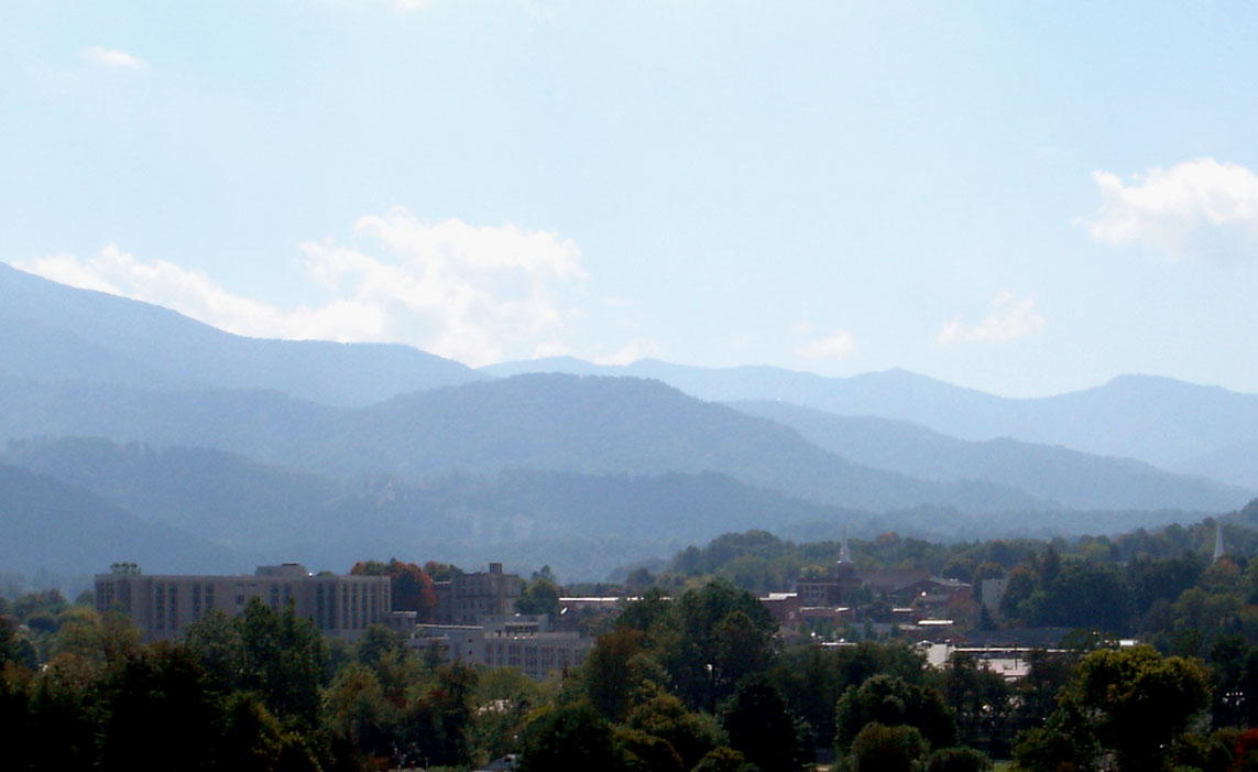
imagesize = 180px
image_caption = Overlooking the town of Waynesville
image_

mapsize = 250x200px
map_caption = Location inNorth Carolina
mapsize1 =
map_caption1 =
subdivision_type = Country
subdivision_type1 = State
subdivision_type2 = County
subdivision_name =United States
subdivision_name1 =North Carolina
subdivision_name2 = Haywood
government_type =
leader_title =Mayor
leader_name = Gavin A. Brown
established_title = Incorporated
established_date = 1871
area_magnitude =
area_total_km2 = 20.1
area_total_sq_mi = 7.8
area_land_km2 = 20.1
area_land_sq_mi = 7.8
area_water_km2 = 0
area_water_sq_mi = 0
area_water_percent = 0
area_urban_km2 =
area_urban_sq_mi =
area_metro_km2 =
area_metro_sq_mi =
latd = 35 |latm = 29 |lats = 0 |latNS = N
longd = 82 |longm = 59 |longs = 40 |longEW = W
population_as_of = 2006
population_note =
population_total = 10000 (est.)
population_metro =
population_urban =
population_density_km2 = 460.1
population_density_sq_mi = 1191.8
timezone = Eastern
utc_offset = -5
timezone_DST = EDT
utc_offset_DST = -4
elevation_m = 839
elevation_ft = 2752
website = [http://www.townofwaynesville.org Town of Waynesville]
postal_code_type =ZIP code s
postal_code = 28738, 28785, 28786
area_code = 828
blank_name = FIPS code
blank_info = 37-71500GR|2
blank1_name = GNIS feature ID
blank1_info = 1023138GR|3
footnotes =Waynesville is an incorporated
town in Haywood County,North Carolina ,United States of America and is its county seatGR|6. It is the largest town in Haywood County and the largest in Western North Carolina west of Asheville. Waynesville is located about convert|30|mi|km or 50 km southwest of Asheville between the Great Smoky andBlue Ridge Mountains . As of the 2000census , the town had a totalpopulation of 9,232 with an estimate (by the town government) of 10,000 as of early 2007. Waynesville is located just outside thePisgah National Forest and is close to theGreat Smoky Mountains National Park and theBlue Ridge Parkway . Waynesville and Haywood County are part of the four-county Asheville Metropolitan Statistical Area, currently the 5th largest metropolitan area inNorth Carolina . It is the third largest town in the MSA behind the cities of Asheville and Hendersonville.Geography
Waynesville is located at coor dms|35|28|60|N|82|59|40|W|city (35.483226, -82.994511)GR|1.
According to the
United States Census Bureau , the town has a total area of 7.8 square miles (20.1 km²), all of it land.Most of the town of Waynesville lies between 2500 and 3000 feet (750~900m)
above sea level , and is located in avalley among 6000-foot (1800m)mountain peaks. AUSGS survey marker at the old Haywood County Courthouse in downtown Waynesville lists the elevation as convert|2752|ft|m abovesea level .Demographics
As of the
census GR|2 of 2000, there were 9,232 people, 4,106 households, and 2,545 families residing in the town. Thepopulation density was 1,191.8 people per square mile (459.9/km²). There were 4,761 housing units at an average density of 614.6/sq mi (237.2/km²). The racial makeup of the town was 94.42% White, 3.31% African American, 0.54% Native American, 0.16% Asian, 0.08% Pacific Islander, 0.76% from other races, and 0.73% from two or more races. Hispanic or Latino of any race were 2.01% of the population.There were 4,106 households out of which 23.2% had children under the age of 18 living with them, 45.0% were married couples living together, 13.1% had a female householder with no husband present, and 38.0% were non-families. 34.0% of all households were made up of individuals and 16.0% had someone living alone who was 65 years or older. The average household size is 2.16 and the average family size is 2.71.
In the town the population is spread out with 19.9% under the age of 18, 6.1% from 18 to 24, 25.5% from 25 to 44, 25.8% from 45 to 64, and 22.7% who are 65 years of age or older. The median age is 44 years. For every 100 females there are 87.2 males. For every 100 females age 18 and over, there are 82.9 males.
The median income for a household in the town is $28,296, and the median income for a family is $36,404. Males have a median income of $26,374 versus $21,159 for females. The
per capita income for the town is $17,821. 15.5% of the population and 12.6% of families are below thepoverty line . Out of the total population, 24.3% of those under the age of 18 and 10.7% of those 65 and older are living below the poverty line.As of late 2006 the town of Waynesville government estimated the population at 10,000.
History
The Town of Waynesville was founded in 1809 by
Colonel Robert Love , anAmerican Revolutionary War soldier. He donated land for the courthouse, jail, and public square, and named the town after his former commander in the war,General "Mad" Anthony Wayne .Waynesville also has a connection to another war. With news of General
Robert E. Lee 's surrender traveling slowly, theAmerican Civil War continued inWestern North Carolina . The final shots of that war, east of theMississippi River , were fired near Sulphur Springs and General James Martin surrendered honorably on May 9, 1865 (See The "Battle" of Waynesville below.)The Town of Waynesville was incorporated in 1871. In July 1995 the Towns of Hazelwood and Waynesville merged into one community and continued to grow with a population today of almost 10,000.
Frog Level
Waynesville began to see development after arrival of the railroad in 1884. The agricultural, lumber and tourism industries in Waynesville and Haywood County began to thrive as access to the west was opened up.
The area of Waynesville located along Richland Creek, northwest and down hill from Main Street, was where the railroad tracks were laid. Until this time the area had been essentially a swampland, with a few scattered buildings but no major development. Once the depot was built and the train arrived this section was developed. It was given the name of Frog Level. Frog Level was so named by the local community because of its low-lying location along Richland Creek, the "frog level" when the area flooded.
Downtown and the nearby Frog Level commercial centers of Waynesville continued to be the central focus for social life, transportation, and wholesale and retail businesses through the 1940s. Businesses in the Frog Level area in the 1930s and 1940s included hardware stores, farm supplies, coal sales, auto dealers and garages, furniture stores, wholesale groceries, warehouses and lumber companies, all businesses dependent on the railroad. However, as the automobile became the primary mode of transportation for most residents, the railroad declined in importance. This in turn lead to a shift of business away from Frog Level. The last passenger train arrived in Waynesville in 1949, and freight trains pass through Frog Level twice daily, with most trains continuing on to Sylva.
By the 1980s the railroad in Waynesville had been integrated into the Southern Railway Company system. The first depot burned in 1900, but it was soon replaced with another depot that remained standing until 1987.
New property owners within the district have begun a new wave of renovation efforts, and Frog Level is once again beginning to serve as a commercial part of the Town. Also Frog Level now sponsors the annual The Whole Bloomin' Thing, a festival of locally produced goods, services, produce and plants, as well as music, food and entertainment. For more information on the revitalization of Frog Level, go to the Frog Level Merchants site: http://froglevelmerchants.com [http://froglevelmerchants.com/]
Popular Culture
* Cold Mountain, located convert|15|mi|km southeast of Waynesville within the
Pisgah National Forest , was made famous by the novel "Cold Mountain" byCharles Frazier . A major motion picture based on the novel was produced byMiramax Films in 2003.* The 1996 movie "
My Fellow Americans " was filmed in Western North Carolina. The scene whereJack Lemmon andJames Garner are chased from a fast food restaurant parking lot in a car and a giant clown sign crashes through their windshield was filmed at theLong John Silver's on Russ Avenue in Waynesville.*Actor
Gig Young , whose real name is Byron Elsworth Barr is buried in the Green Hill Cemetery.Neighborhoods
* Downtown - The primary retail business center of the town, downtown Waynesville is now home to art galleries, cafes and restaurants, shops, banks, doctors, and the town government/administration buildings.
* Frog Level - The historic district whose name came about because of frequent flooding of Richland Creek. In the 70s and 80s it was known as a seedy part of downtown, mainly due to a now-closed bar called The Tap Room. In recent years, the revitalization of Main Street has spread down into this area. A mural in the area depicts a frog sitting on a level. The historic
Murphy Branch of the oldWestern North Carolina Railroad runs through Frog Level and still carries freight rail traffic fromNorfolk Southern Railway which now owns the line.* Hazelwood - Due to financial troubles, this once independent town ceased to exist and was annexed by Waynesville in 1995
* Laurel Ridge - The Laurel Ridge neighborhood is connected to a country club of the same name, and features a golf course, pool, tennis courts, and upscale mountain homes.
* West Waynesville - The once industrial part of town. A large shopping center called Waynesville Commons now sits on the site of the old Dayco factory and includes a
Wal-Mart Super Center.* Russ Avenue - The newer business district, which features restaurants, retail stores, auto dealerships, banks, grocery stores, and the like. Russ Avenue is the most traveled surface street in Haywood County.
The "Battle" of Waynesville
Waynesville was the scene of the last and perhaps most unusual skirmish in the eastern theater of the
American Civil War . On May 6, 1865, Union Colonel William C. Bartlett's 2nd North Carolina (Federal)Mounted Infantry were raiding, pilaging, burning homes and engaging in other activities to undermine the economic base of the area and were attacked at White Sulphur Springs (east of Waynesville) by a detachment of rebels from the Thomas Legion of Highlanders, who had been summoned for help by locals. East of the Mississippi, Thomas' Legion fired "The Last Shot" of the Civil War in White Sulphur Springs, North Carolina. The Legion consisted of soldiers who had served under Jubal A. Early during theShenandoah Valley Campaigns of 1864, but had been sent back to their native North Carolina mountains to engage in guerrilla warfare against the remaining Union forces.The disoriented Union soldiers retreated into Waynesville, and on the evening of May 6 remaining elements of the Thomas Legion surrounded the town. The soldiers lit numerous bonfires on the ridges above the town and engaged in war chants in an effort to intimidate the Federals. The following day the Confederate commanders Gen. James Green Martin and Col.William Holland Thomas (for whom the Legion was named) negotiated a surrender. These commanders had been made aware that GeneralsRobert E. Lee andJoseph E. Johnston had already capitulated, and that continued hostilities would prove pointless.Transportation
Waynesville is serviced by two or more freight trains daily via the
Norfolk Southern Railway and is connected to Interstate 40 and the rest of Southwestern North Carolina via theGreat Smoky Mountains Expressway giving it easy access toKnoxville, Tennessee and Asheville. There is no airport in Haywood County mostly due to its close proximity to theAsheville Regional Airport and Knoxville'sMcGhee Tyson Airport . Asheville is about a 30 minute drive east, Knoxville is an hour and a half to the west.chools
*
Tuscola Senior High School
*Waynesville Middle School
*Central Elementary School Waynesville Watershed
Waynesville’s watershed is located southwest of the town and covers an area of convert|8400|acre|km2 of town-owned land on the headwaters of Allens Creek making it much larger than the town itself (7.9 square miles.) Tributary streams within the watershed flow into the Waynesville Reservoir, a 50 acre man-made lake created by a dam on Allens Creek. The reservoir and surrounding watershed are classified by the State of North Carolina as WS-1. This classification is the state’s most stringent and forbids development within the watershed boundary.
Political Controversies
Waynesville attracted national media attention in 2005 when
Chan Chandler , the pastor ofEast Waynesville Baptist Church , expelled nine church members because they had voted forJohn Kerry , the Democratic candidate in the 2004 United Statespresidential election . Forty other members of the church resigned in protest and the pastor was eventually forced to step down under pressure from his congregation and other members of the community. [http://www.usatoday.com/news/nation/2005-05-07-church-politics_x.htm USA Today Story] The town also received repeated media attention throughout the 1990s due to a lawsuit by theACLU on behalf of atheist and gadfly Richard Suhre, who had moved to Waynesville from Indianapolis, Indiana. Suhre perceived discrimination when he refused to swear on the Bible during an unrelated court case in 1994, which he subsequently lost. WithACLU support, Suhre sued Haywood County to remove a courtroom plaque displaying theTen Commandments . Many local Protestant groups rallied to defend the Decalog during the late 1990s, sporting bumper stickers reading "I Support the Ten." Churches also promoted the argument that the display had been part of the original courthouse, which had been zoned historical. However, little historical argument was forthcoming in the vituperation that followed in the press. Suhre's lawsuit was dismissed by the conservative District Judge Lacy Thornburg on several occasions. This controversy formally ended with Suhre's death in late 1999, but ACLU efforts to rekindle the case proved ineffectual, owing to an unusual court ruling in 2000 that new plaintiffs could not "inherit" Suhre's case. The Decalog display still remains in the old county courthouse, which has been eclipsed by the newer -- somewhat secularized -- Haywood County Justice Center on Main Street.References
External links
* [http://www.townofwaynesville.org/ Official website of the Town of Waynesville, NC]
* [http://www.waynesvillelive.com/ Waynesville Live]
* [http://www.themountaineer.com/ The Mountaineer Newspaper]
* [http://www.downtownwaynesville.com/ Downtown Waynesville Association]
* [http://www.waynesvillegalleryassociation.com/ Waynesville Gallery Association]
* [http://www.waynesvillepd.com/ Waynesville Police Department]
* [http://www.waynesvillefire.org/ Waynesville Fire Department]
* [http://townofwaynesville.org/recreation/ Waynesville Parks and Recreation Department]
* [http://www.city-data.com/city/Waynesville-North-Carolina.html Waynesville City Data]
Wikimedia Foundation. 2010.