- Lexington, North Carolina
-
Lexington, North Carolina — City — Nickname(s): Barbecue Capital of the World Location in Davidson County and the state of North Carolina Coordinates: 35°49′0″N 80°15′31″W / 35.816667°N 80.25861°WCoordinates: 35°49′0″N 80°15′31″W / 35.816667°N 80.25861°W Country United States State North Carolina County Davidson Government – Type Mayor-council government – Mayor John T. Walser, Jr. Area – Total 17.6 sq mi (45.6 km2) – Land 17.6 sq mi (45.6 km2) – Water 0 sq mi (0 km2) Elevation 809 ft (246.5 m) Population (2007) – Total 21,149 Time zone EST (UTC-5) – Summer (DST) EDT (UTC-4) ZIP codes 27292-27295 Area code(s) 336 FIPS code 37-38060[1] GNIS feature ID 0988406[2] Website www.lexingtonnc.net Lexington is the county seat of Davidson County, North Carolina, United States. As of the 2000 census, the city had a total population of 19,953. It is located in central North Carolina, twenty miles (32 km) south of Winston-Salem. Major highways include I-85, U.S. Route 29, U.S. Route 70, U.S. Route 52 (soon to be I-285) and U.S. Route 64. Lexington is part of the Piedmont Triad region of the state.
Lexington, Thomasville, and the rural areas surrounding them are slowly turning into bedroom communities for nearby cities such as Winston-Salem, Greensboro and High Point.
Contents
History
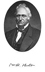
 Dr. William Rainey Holt built Lexington's oldest home, The Homestead, listed on the National Register of Historic Places
The Lexington area was at least sparsely settled by Europeans in 1775. The settlers named their community in honor of Lexington, Massachusetts, the site of the first skirmish of the American Revolutionary War. Lexington was incorporated as a city in 1828. Until the late 1990s, Lexington's economy was mainly textile and furniture manufacturing-based. Since then, most local manufacturers have moved their production facilities to Asia and Mexico as a way to reduce costs and remain competitive in a global market. This caused the closure of most textile and furniture factories and has contributed to economic difficulties for a community that was heavily dependent on these two industries for employment.
Silver Hill Mine, located a few miles south of Lexington, opened in 1838, and was the first operating silver mine in the country.[citation needed]
The oldest remaining house in Lexington is The Homestead, built by Dr. William Rainey Holt (1798–1868), a physician born in what is today Alamance County.[3] The Homestead has windows, sidelights and other Palladian details characteristic of the pattern books of architect Asher Benjamin.[4] The home's owner was a Pennsylvania-trained physician who practiced medicine after relocating to Davidson County. An ardent Secessionist, Dr. Holt lost three sons during the Civil War and his home was occupied by Union Army soldiers. Following the War, Holt spent an increasing amount of time at his plantation Linwood, located southwest of Lexington, where he operated a scientific farm on his 1,600 acres (6.5 km2), and where, as President of the North Carolina Agricultural Society, Holt was among the first to introduce purebred breeds of livestock to North Carolina.[5]
Local Culture
Barbecue
Main article: Lexington Barbecue FestivalLexington calls itself the "Barbecue Capital of the World".[6] Since 1984, the city has hosted the Lexington Barbecue Festival, one of the largest street festivals in North Carolina. As of 2003, the city has over twenty barbecue restaurants: an average of more than one per thousand residents.
Lexington-style barbecue is made with pork shoulder cooked slowly over a hardwood fire, usually hickory wood. It is basted in a sauce (called "dip" locally) made with vinegar, ketchup, water, salt, pepper and other spices. The actual ingredients will vary from restaurant to restaurant, with each restaurant's recipe being a closely guarded secret. While each is vinegar based, the taste varies widely from tangy to slightly sweet or spicy.
The most distinguishing feature of the "Lexington Barbecue Sandwich" is the inclusion of red slaw (sometimes called barbecue slaw). Red slaw is a combination of cabbage, vinegar, ketchup and crushed/ground black pepper. Red slaw is distinguishable from coleslaw because red slaw contains no mayonnaise. Many Lexingtonians (and visitors) consider red slaw a staple for a quality barbecue experience. Red slaw is commonly served as a side dish with barbecue, grilled poultry and other meats, and on hotdogs as a relish.
Pigs in the City
Main article: Pigs in the CityPigs in the City is a public art initiative coordinated by Uptown Lexington, Inc.,[7] a non-profit organization created to revitalize the downtown (or locally called "uptown") area of Lexington. It includes an annual event held in the fall in the uptown business district. Pigs in the City began in 2003[8] when the event drew over 40,000 visitors from all over the state in its first year.[9] It became an annual event after 2006. The cost to "sponsor" one of the 20 pigs on display was $1,000 during the first exhibition, which paid for the initiative.[9]
High Rock Lake
Main article: High Rock LakeHigh Rock Lake is the second largest lake in North Carolina and located just a few miles south of Lexington. Its water surface covers 15,180 acres (61 km2) and there are 365 miles (587 km) of shoreline. It begins at the confluence of the Yadkin River and the South Yadkin River.
High Rock Lake has long been considered one of the best fishing lakes of North Carolina.[10] It has been the host of Bassmaster Tournaments, including the Bassmaster Classic in 1994, 1995, 1997 and 2007 [11] and is the site of frequent other angling competitions. The lake has ample channel, blue, and flathead catfish, plus crappie and several different sunfish such as bluegill, shellcracker and others. Striper and their hybrids as well as white bass are also abundant. The lake is best known for its quantity and quality of largemouth bass, which attract anglers from all over the United States. This is likely due to the relatively shallow nature of the lake and the tremendous amount of habitat that favor the bass.
The Bob Timberlake Gallery
The Bob Timberlake Gallery[12] is located in Lexington. It opened in 1997, and features original artwork, reproductions, personal memorabilia, as well as home furnishings from the artist.
Geography
Lexington is located in the Piedmont. It is centered at 35°49'0" North, 80°15'31" West (35.816768, -80.258643)[13], in the valley of the Yadkin River. Lexington is 11 miles (18 km) northeast of High Rock Lake, part of the Yadkin-Pee Dee chain of lakes in central North Carolina.
According to the United States Census Bureau, the city has a total area of 17.6 square miles (46 km2), of which, 17.6 square miles (46 km2) of it is land and none of the area is covered with water.
It is bordered to the north and west by Interstate 85 Business, to the south and east by Interstate 85. Both interstates merge just southwest of the city. Additionally, 4 U.S. Highway Routes, U.S. Route 29, U.S. Route 64, U.S. Route 52, U.S. Route 70 and state highways NC Highway 8 and NC Highway 47 intersect the city.
Climate
Thunderstorms are common during the spring and summer months, including some severe storms. Being located in central North Carolina, between the Appalachian Mountains and the Mid-Atlantic coast, Lexington has a humid subtropical climate, with moderate temperatures during spring and autumn and warm to hot summers. Winters are relatively mild and wet with highs typically in the 40s to 50s and overnight lows averaging just below freezing.
Climate data for Lexington, North Carolina Month Jan Feb Mar Apr May Jun Jul Aug Sep Oct Nov Dec Year Average high °F (°C) 49.6
(9.8)54.4
(12.4)63.3
(17.4)72.5
(22.5)79.3
(26.3)85.5
(29.7)89.1
(31.7)87.4
(30.8)81.6
(27.6)71.9
(22.2)61.7
(16.5)52.6
(11.4)70.7 Average low °F (°C) 28.6
(−1.9)30.9
(−0.6)38.0
(3.3)45.3
(7.4)54.5
(12.5)62.9
(17.2)67.1
(19.5)65.5
(18.6)59.1
(15.1)46.7
(8.2)37.9
(3.3)31.0
(−0.6)47.3 Precipitation inches (mm) 4.06
(103.1)3.78
(96)4.31
(109.5)3.63
(92.2)3.93
(99.8)4.06
(103.1)3.85
(97.8)3.63
(92.2)3.84
(97.5)3.52
(89.4)3.47
(88.1)3.37
(85.6)45.45
(1,154.4)Snowfall inches (cm) 2.4
(6.1)2.8
(7.1)1.2
(3)0
(0)0
(0)0
(0)0
(0)0
(0)0
(0)0
(0)0
(0)0.6
(1.5)7
(18)Avg. precipitation days 10.2 9.3 10.2 9.0 10.0 9.5 10.4 8.4 7.7 6.6 8.8 9.6 109.7 Avg. snowy days 0.8 0.9 0.4 0 0 0 0 0 0 0 0 0.3 2.4 Sunshine hours 170.5 175.2 229.4 246.0 260.4 270.0 269.7 248.0 225.0 220.1 174.0 164.3 2,652.6 Source: NOAA,[14] HKO (sun) [15] Demographics
As of the census[1] of 2010, there are 18,931 people in the city, organized into 7,376 households. This represents a population reduction of 1022 persons, or 5%, when compared to the 2000 census. The median age is 37.4 years for all persons (39.4 for females, 35.2 for males).
Of the total population, 15.1% are at least 65 years old, 24.6% are under the age of 18, with the remaining 60.3% of the population being persons from 18 to 64. Males comprise 48.1% and females make up 51.9% of the total population. Caucasians make up 54.7% of the total population (including 16.3% that are Latino), African-Americans 28.4% and Asians represent 2.9% of the population. Fully 10.7% of the population identifies itself as Some other race while 2.6% are Two or more races. Other races each represent less than 1% each of the total population.
Of the total 7,376 households, 4,581 are considered Family households, including 2067 that have children under 18. The average household size is 2.44 persons, and the average family size is 3.08 persons. There are 8,938 total housing units, of which the 7376 are households, for an occupancy rate of 82.5%. 47.6% of these households are owner-occupied, while 52.4% are renters.
According to the 2000 census, The median income for a household in the city is $26,226, and the median income for a family is $32,339. Males have a median income of $25,555 versus $20,939 for females. The per capita income for the city is $15,310. 21.2% of the population and 16.7% of families are below the poverty line. Out of the total population, 31.7% of those under the age of 18 and 18.0% of those 65 and older are living below the poverty line. The global outsourcing of textile and furniture manufacturing has negatively impacted Lexington's economy.[16]
Notable people
- Bob Timberlake, local artist,[17]
- Robert Sink, Lieutenant General for the United States Army during World World II. Sink was portrayed in the television miniseries Band of Brothers by Captain Dale Dye.[citation needed]
- Perry Tuttle, former NFL wide receiver for the Buffalo Bills, Atlanta Falcons, and Tampa Bay Buccaneers[18]
- Deems May, former NFL tight end for the San Diego Chargers and the Seattle Seahawks[19]
- Mike Dillon, former NASCAR Busch Series race car driver. Spotter for RCR driver Clint Bowyer [20]
- Terry McMillan, musician [21]
- Rick Terry, NFL defensive tackle for the New York Jets and Carolina Panthers.[22]
- Richard "The Old Man" Harrison of the famous reality TV Show Pawn Stars.[23]
Images gallery
-
Korean War Memorial
-
Vietnam War Memorial
-
World War II Memorial
-
Childress Vineyards is a popular destination
See also
- Piedmont Triad
- Lexington Barbecue Festival
- Pigs in the City
- Davidson County, North Carolina
References
- ^ a b "American FactFinder". United States Census Bureau. http://factfinder.census.gov. Retrieved 2008-01-31.
- ^ "US Board on Geographic Names". United States Geological Survey. 2007-10-25. http://geonames.usgs.gov. Retrieved 2008-01-31.
- ^ William Rainey Holt, Biographical History of North Carolina from Colonial Times to the Present, Vol. VII, Samuel A'Court Ashe, Charles L. Van Noppen, Publisher, Greensboro, N.C., 1908
- ^ Historic Uptown Lexington, North Carolina
- ^ William Rainey Holt, North Carolina Highway Historical Marker Program
- ^ http://www.visitlexingtonnc.com Lexington Tourism Authority website
- ^ http://www.uptownlexington.org/Events/pigsinthecity.asp
- ^ http://www.electricities.com/press/news/morganton_hosts.htm
- ^ a b "LIFE-SIZE PORKER PROMOTION PROVES POPULAR TO PUBLIC". Greensboro News-Record.
- ^ North Carolina Summer Bass Fishing
- ^ Camping in Piedmont, North Carolina
- ^ https://www.bobtimberlake.com/bob-timberlake-gallery.cfm
- ^ "US Gazetteer files: 2010, 2000, and 1990". United States Census Bureau. 2011-02-12. http://www.census.gov/geo/www/gazetteer/gazette.html. Retrieved 2011-04-23.
- ^ "Climatography of the United States No. 20 (1971–2000)" (PDF). National Oceanic and Atmospheric Administration. August 2011. http://cdo.ncdc.noaa.gov/climatenormals/clim20/nc/314970.pdf. Retrieved 2011-04-17.
- ^ "Climatological Normals of Greensboro". Hong Kong Observatory. http://www.weather.gov.hk/wxinfo/climat/world/eng/n_america/us/Greensboro_e.htm. Retrieved 2010-06-15.
- ^ http://www.the-dispatch.com/article/20081209/ARTICLES/812090297/1005/NEWS The Dispatch (Lexington, NC)
- ^ https://www.bobtimberlake.com/biography.cfm
- ^ http://www.pro-football-reference.com/players/T/TuttPe00.htm
- ^ http://www.pro-football-reference.com/players/M/MayxDe00.htm
- ^ http://www.racing-reference.info/driver?id=dillomi01
- ^ http://www.cmt.com/news/country-music/1551563/harmonica-wizard-terry-mcmillan-dead-at-53.jhtml
- ^ http://www.pro-football-reference.com/players/T/TerrRi20.htm
- ^ "Chummobile", Pawn Stars, Season 4, Episode 16, March 28, 2011
External links
- Official website
- Lexington Area Chamber of Commerce
- Lexington Tourism Authority
- Lexington's Annexation
- About Lexington's annexation
- Uptown Lexington, Inc.
- Arts United for Davidson County
- Lexington's Barbecue Festival
- Davidson Co. Tourism and Recreation
- Images and Feature Articles
- Photographs of Lexington buildings from the Library of Congress "Built in America" collection
Municipalities and communities of Davidson County, North Carolina County seat: LexingtonCities High Point‡ | Lexington | Thomasville‡
Towns CDP Unincorporated
communitiesArcadia | Bethesda | Churchland | Linwood | Montclair | Reeds | Silver Valley | Southmont | Tyro | Yadkin College
Footnotes ‡This populated place also has portions in an adjacent county or counties
 State of North Carolina
Topics - Climate
- Culture
- Economy
- Education
- Geography
- History
- Music
- North Carolinians
- Politics
- State Parks
- Wildlife
- Visitor attractions
Regions Larger cities Smaller cities - Albemarle
- Apex
- Asheboro
- Burlington
- Chapel Hill
- Conover
- Eden
- Elizabeth City
- Goldsboro
- Graham
- Havelock
- Henderson
- Hendersonville
- Hickory
- Kannapolis
- Kings Mountain
- Kinston
- Laurinburg
- Lenoir
- Lexington
- Lumberton
- Monroe
- Morganton
- New Bern
- Newton
- Reidsville
- Roanoke Rapids
- Rocky Mount
- Salisbury
- Sanford
- Shelby
- Statesville
- Thomasville
- Waynesville
- Wilson
Major towns - Beaufort
- Boone
- Carrboro
- Clayton
- Conover
- Cornelius
- Dunn
- Fuquay-Varina
- Garner
- Harrisburg
- Holly Springs
- Hope Mills
- Huntersville
- Indian Trail
- Kernersville
- Knightdale
- Leland
- Matthews
- Midland
- Mint Hill
- Mooresville
- Morehead City
- Morrisville
- Mount Pleasant
- Oxford
- Shallotte
- Smithfield
- Southern Pines
- Tarboro
- Wake Forest
Counties - Alamance
- Alexander
- Alleghany
- Anson
- Ashe
- Avery
- Beaufort
- Bertie
- Bladen
- Brunswick
- Buncombe
- Burke
- Cabarrus
- Caldwell
- Camden
- Carteret
- Caswell
- Catawba
- Chatham
- Cherokee
- Chowan
- Clay
- Cleveland
- Columbus
- Craven
- Cumberland
- Currituck
- Dare
- Davidson
- Davie
- Duplin
- Durham
- Edgecombe
- Forsyth
- Franklin
- Gaston
- Gates
- Graham
- Granville
- Greene
- Guilford
- Halifax
- Harnett
- Haywood
- Henderson
- Hertford
- Hoke
- Hyde
- Iredell
- Jackson
- Johnston
- Jones
- Lee
- Lenoir
- Lincoln
- Macon
- Madison
- Martin
- McDowell
- Mecklenburg
- Mitchell
- Montgomery
- Moore
- Nash
- New Hanover
- Northampton
- Onslow
- Orange
- Pamlico
- Pasquotank
- Pender
- Perquimans
- Person
- Pitt
- Polk
- Randolph
- Richmond
- Robeson
- Rockingham
- Rowan
- Rutherford
- Sampson
- Scotland
- Stanly
- Stokes
- Surry
- Swain
- Transylvania
- Tyrrell
- Union
- Vance
- Wake
- Warren
- Washington
- Watauga
- Wayne
- Wilkes
- Wilson
- Yadkin
- Yancey
Categories:- Populated places established in 1775
- Cities in North Carolina
- Populated places in Davidson County, North Carolina
- County seats in North Carolina
Wikimedia Foundation. 2010.


