- Pee Dee River
Geobox | River
name = Pee Dee River
category = River

image_size = 300
image_caption =Shad Fishing in FebruaryPee Dee River, Yauhannah, South Carolina
etymology = Pee Dee tribe
country = United States
country_
state = North Carolina
state1 = South Carolina
region_type = County
region =
district =
parent =
tributary_left =
tributary_right =
source = Confluence ofUwharrie River andYadkin River
source_location =
source_region =
source_state = North Carolina
source_elevation_imperial =
source_elevation_note =
source_length_imperial =
source_lat_d = 35
source_lat_m = 22
source_lat_s = 51
source_lat_NS = N
source_long_d = 80
source_long_m = 3
source_long_s = 29
source_long_EW = W
source_coordinates_note = GNIS|1251573|Pee Dee River]
mouth =Winyah Bay
mouth_location =
mouth_district =
mouth_region =
mouth_state = South Carolina
mouth_country =
mouth_note =
mouth_lat_d = 34
mouth_lat_m = 43
mouth_lat_s = 16
mouth_lat_NS = N
mouth_long_d = 79
mouth_long_m = 52
mouth_long_s = 54
mouth_long_EW = W
mouth_coordinates_note =
mouth_elevation_imperial = 0
mouth_elevation_note =
length_imperial = 60
length_note =
watershed_imperial =
watershed_note =
discharge_location =
discharge_round =
discharge_imperial =
discharge_note =
discharge_min_imperial =
discharge_max_imperial =
discharge1_location =
discharge1_imperial =
discharge1_note =
map_size = 300
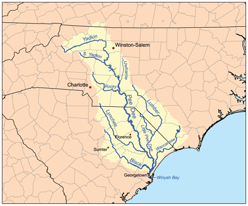
map_caption = Pee Dee River watershed.
commons = The Pee Dee River, also known as the Great Pee Dee River, is ariver inNorth Carolina andSouth Carolina . It originates in theAppalachian Mountains inNorth Carolina , where its upper course above the mouth of theUwharrie River is known as theYadkin River , and it is extensively dammed for flood control andhydroelectric power. The lower part of the river is named Pee Dee (in colonial times written Pedee) after the Native American Pee Dee tribe. The tribe or the river also give the name to thePee Dee region of South Carolina, composed of the northeastern counties of the state.The river is navigable up the
fall line atCheraw, South Carolina and was an important trade route from colonial time. The largestlumber company in the world existed at the turn of the 20th century near the river's mouth atGeorgetown, South Carolina . The virginpine forests of the Pee Dee region were cut over and the logs floated in rafts downriver to be sawn into lumber and exported to the northern USA andEurope .The lower part of the river
flood plain was extensively developed forrice culture in colonial time, as rice was a major export of the area from the port at Georgetown. Rice culture declined with the loss of slave labor after the Civil War, and increased competition. Two hurricanes at the beginning of the 20th century destroyed much of the canal work and effectively ended the remnants of rice culture.Today the river is not extensively used for navigation. It is an important source of electric power and public water supplies, as well as recreational use. While the Pee Dee is free-flowing in South Carolina, upstream in North Carolina several dams have been constructed on it. The opening and closing of these dams causes dramatic swings in the depth of the river in South Carolina. The sharing of water between the two states has sometimes been a matter of controversy, particularly during period of drought. Some commercial fishing is done during the winter
shad run, and forshrimp in the lower reaches. The river is excellent for recreational fishing and boating. There are numerous boat landings, yet most of the river is wild, with forests oftupelo ,oak and gum along its shores.Heron s andalligator s can be seen along the way, and a lucky sighting of abald eagle is possible.The lower part of the river from Highway 378 to
Winyah Bay has been designated a Scenic River. [http://www.dnr.sc.gov/water/envaff/river/desig_rivers.html]Some tributaries are the Lumber, the Little Pee Dee,
Lynches River , Black River andWaccamaw River . The river empties intoWinyah Bay , and then into theAtlantic Ocean near Georgetown.Snow's Island is a large island at the junction of the Pee Dee and Lynches rivers. This was headquarters for General
Francis Marion during theAmerican Revolution . It proved a safe haven for him and his ragtagmilitia troops, as the British were never able to find the camp. It has been identified as the center of an oldmeteor crater).The Pee Dee River was the original river for
Stephen Foster 's song "Old Folks at Home " (commonly known by its first line, "Way down upon the Swanee River"). Why he changed it in his final version is a subject of much speculation.ee also
*
List of North Carolina rivers
*List of South Carolina rivers
*Yadkin River References

Wikimedia Foundation. 2010.