- Clay County, North Carolina
-
Clay County, North Carolina 
Location in the state of North Carolina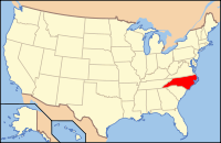
North Carolina's location in the U.S.Founded 1861 Seat Hayesville Area
- Total
- Land
- Water
221 sq mi (572 km²)
215 sq mi (557 km²)
6 sq mi (16 km²), 2.67%Population
- (2000)
- Density
8,775
41/sq mi (16/km²)Clay County is a county located in the U.S. state of North Carolina. As of 2000, the population was 8,775. Its county seat is Hayesville[1].
Contents
History
Main article: Cherokee IndiansBefore settlement, Clay County was home to the Cherokee Indians, who were a tribe of Native Americans that made their home in Southeastern United States (principally Georgia, the Carolinas and Eastern Tennessee) They were one of the "Five Civilized Tribes" because of their assimilation of European-American cultural and technological practices. During the late 1700's, the first European-American settler, John Covington Moore, settled here in what was then part of Macon County. The first emigrants moved to this area in the early 1830's.
In 1837, General Winfield Scott was hired to gather all the Native Americans in the region and detain them in improvised stockades before transporting them into Oklahoma Territory. Captain Hembree was sent to an area about a mile southwest of Hayesville to construct a stockade to hold the Native Americans until they had all been gathered up. This marks the beginning of the Trail of Tears. The stockade was named after Captain Hembree as Fort Hembree and served as a center of business.
In the Fall of 1860, George Hayes, who was running for Representative from Cherokee County, promised his southeastern constituents to introduce legislation to form a new county. In February of 1861 the legislation was introduced and passed by the North Carolina General Assembly.[2]
Clay County was formed primarily from Cherokee County, North Carolina, however a small area was taken from Macon County, North Carolina. In honor of Mr. Hayes, the then new county's seat was appointed Hayesville and the newly formed county was named in honor Henry Clay, famous American statesman, member of the United States Senate from Kentucky.[2]
Despite having been created in 1861, Clay County lacked an organized, formal government until 1868. Later that year, the first post office opened in Hayesville and the first county courthouse was built in 1888, currently it is listed on the National Register of Historic Places.[3]
Throughout the rest of the nineteenth and early twentieth centuries, Clay County has remained largely agricultural.[2]
Climate and Weather
Clay County has a humid subtropical climate, (Cfa) according to the Köppen classification, with hot, humid summers and mild, but occasionally cold winters by the standards of the southern United States.[4]
Like the rest of the southeastern U.S., Clay County receives abundant rainfall, which is relatively evenly distributed throughout the year. Average annual rainfall is 55.9 inches (1,420 mm). Blizzards are rare but possible; one nicknamed the 1993 Storm of the Century hit the entire Eastern United States in March, 1993.
Law and government
The county government is a constitutional body and is granted specific powers by the Constitution of North Carolina. Clay County is a member of the regional Southwestern Commission council of governments.
Geography
According to the U.S. Census Bureau, the county has a total area of 221 square miles (572.4 km2), the smallest county in North Carolina, of which 215 square miles (556.8 km2) is land and 6 square miles (15.5 km2) (2.67%) is water.
Clay County is bordered to the south by the state of Georgia and the Chattahoochee National Forest. The Nantahala River forms part of its northeastern border. The county is drained by the Hiwassee River. In the southern part of Clay County is Chatuge Lake, on the North Carolina–Georgia border. Much of Clay County exists within the Nantahala National Forest. Fires Creek Bear Reserve is north of the township of Tusquittee.
The eastern portion of the county is preserved as part of the Nantahala National Forest.
There are five counties adjacent to Clay County; Macon County to the northeast; Rabun County to the southeast; Towns County, Georgia, to the south; Union County, Georgia to the southwest; Cherokee County, to the north.

Cherokee County Macon County 
 Clay County, North Carolina

Union County, Georgia Towns County, Georgia Rabun County, Georgia Communities and Townships
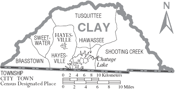
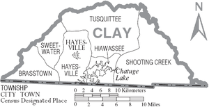 Map of Clay County, North Carolina With Municipal and Township Labels
Hayesville, with a 2000 population of 297, is the only incorporated town in the county, the county seat, and center of economic activity for Clay County. Warne, Brasstown, Elf and Tusquittee are all unincorporated communities of Clay County.
The county is divided into six townships: Brasstown comprises the westernmost township, Hayesville is centrally located and home to the county seat, Hiawassee is the smallest and surrounds Lake Chatuge, Shooting Creek is the westernmost township, Sweetwater is a small township northwest of Hayesville Township, and Tusquittee, one of the larger townships and most northern.
Demographics
As of the census[5] of 2000, there were 8,775 people, 3,847 households, and 2,727 families residing in the county. The population density was 41 people per square mile (16/km²). There were 5,425 housing units at an average density of 25 per square mile (10/km²). The racial makeup of the county was 98.01% White, 0.80% Black or African American, 0.33% Native American, 0.09% Asian, 0.07% Pacific Islander, 0.15% from other races, and 0.56% from two or more races. 0.83% of the population were Hispanic or Latino of any race.
There were 3,847 households out of which 23.50% had children under the age of 18 living with them, 59.80% were married couples living together, 7.50% had a female householder with no husband present, and 29.10% were non-families. 26.30% of all households were made up of individuals and 14.40% had someone living alone who was 65 years of age or older. The average household size was 2.25 and the average family size was 2.68.
In the county the population was spread out with 18.60% under the age of 18, 6.20% from 18 to 24, 22.80% from 25 to 44, 29.80% from 45 to 64, and 22.70% who were 65 years of age or older. The median age was 47 years. For every 100 females there were 94.90 males. For every 100 females age 18 and over, there were 91.40 males.
The median income for a household in the county was $31,397, and the median income for a family was $38,264. Males had a median income of $29,677 versus $19,529 for females. The per capita income for the county was $18,221. About 7.80% of families and 11.40% of the population were below the poverty line, including 14.60% of those under age 18 and 13.00% of those age 65 or over.
See also
External links
References
- ^ "Find a County". National Association of Counties. http://www.naco.org/Counties/Pages/FindACounty.aspx. Retrieved 2011-06-07.
- ^ a b c http://www.ncmtnchamber.com/history-of-clay-county
- ^ http://www.hayesville.org/default.htm
- ^ Koppen Classification Map
- ^ "American FactFinder". United States Census Bureau. http://factfinder.census.gov. Retrieved 2008-01-31.
Municipalities and communities of Clay County, North Carolina Town 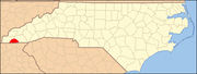
Unincorporated
communitiesBrasstown | Elf | Tusquittee | Warne
Townships Brasstown | Hayesville | Hiawassee | Sweetwater | Shooting Creek | Tusquittee
Categories:- North Carolina counties
- Clay County, North Carolina


Wikimedia Foundation. 2010.