- Clay County, Texas
-
Clay County, Texas 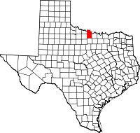
Location in the state of Texas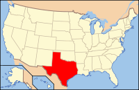
Texas's location in the U.S.Founded 1857 Seat Henrietta Area
- Total
- Land
- Water
1,116 sq mi (2,890 km²)
1,098 sq mi (2,844 km²)
18 sq mi (47 km²), 1.64%Population
- (2010)
- Density
10,752
10/sq mi (4/km²)Website www.co.clay.tx.us Clay County is a county located in the U.S. state of Texas. The county was founded in 1857. Its name is in honor of Henry Clay, famous American statesman, member of the United States Senate from Kentucky and United States Secretary of State in the 19th century. It is part of the Wichita Falls, Texas, Wichita Falls metropolitan area. In 2010, its population was 10,752. The seat of the county is Henrietta.
Contents
Geography
According to the U.S. Census Bureau, the county has a total area of 1,116 square miles (2,890.4 km2), of which 1,098 square miles (2,843.8 km2) is land and 18 square miles (46.6 km2) (1.64%) is water.
Major highways
 U.S. Highway 82
 U.S. Highway 287
 State Highway 79
 State Highway 148
Farm to Market Roads
Adjacent counties
- Jefferson County, Oklahoma (north)
- Montague County (east)
- Jack County (south)
- Wichita County (west)
- Archer County (west)
- Cotton County, Oklahoma (northwest)
Demographics
Historical populations Census Pop. %± 1880 5,045 — 1890 7,503 48.7% 1900 9,231 23.0% 1910 17,043 84.6% 1920 16,864 −1.1% 1930 14,545 −13.8% 1940 12,524 −13.9% 1950 9,896 −21.0% 1960 8,351 −15.6% 1970 8,079 −3.3% 1980 9,582 18.6% 1990 10,024 4.6% 2000 11,006 9.8% Est. 2009 10,893 −1.0% U.S. Census Bureau[1] Texas Almanac[2] As of the census[3] of 2000, there were 11,006 people, 4,323 households, and 3,181 families residing in the county. The population density was 10 people per square mile (4/km²). There were 4,992 housing units at an average density of 4 per square mile (2/km²). The racial makeup of the county was 95.35% White, 0.42% Black or African American, 1.03% Native American, 0.10% Asian, 0.01% Pacific Islander, 1.68% from other races, and 1.42% from two or more races. 3.67% of the population were Hispanic or Latino of any race.
There were 4,323 households out of which 30.70% had children under the age of 18 living with them, 63.20% were married couples living together, 7.30% had a female householder with no husband present, and 26.40% were non-families. 23.50% of all households were made up of individuals and 11.80% had someone living alone who was 65 years of age or older. The average household size was 2.52 and the average family size was 2.98.
In the county, the population was spread out with 24.90% under the age of 18, 6.80% from 18 to 24, 26.40% from 25 to 44, 25.90% from 45 to 64, and 16.10% who were 65 years of age or older. The median age was 40 years. For every 100 females there were 94.00 males. For every 100 females age 18 and over, there were 93.10 males.
The median income for a household in the county was $35,738, and the median income for a family was $41,514. Males had a median income of $28,914 versus $20,975 for females. The per capita income for the county was $16,361. About 8.10% of families and 10.30% of the population were below the poverty line, including 11.70% of those under age 18 and 11.00% of those age 65 or over.
Cities and towns
- Bellevue
- Bluegrove
- Buffalo Springs
- Byers
- Charlie
- Dean
- Halsell
- Henrietta
- Hurnville
- Jolly
- Joy
- Petrolia
- Scotland (partially)
- Shannon
- Stanfield
- Thornberry
- Vashti
See also
References
- ^ http://factfinder.census.gov/servlet/SAFFPopulation?_event=Search&geo_id=05000US48337&_geoContext=01000US%7C04000US48%7C05000US48337&_street=&_county=clay+county&_cityTown=clay+county&_state=04000US48&_zip=&_lang=en&_sse=on&ActiveGeoDiv=geoSelect&_useEV=&pctxt=fph&pgsl=050&_submenuId=population_0&ds_name=null&_ci_nbr=null&qr_name=null®=null%3Anull&_keyword=&_industry=
- ^ http://www.texasalmanac.com/population/population-counties-history.pdf
- ^ "American FactFinder". United States Census Bureau. http://factfinder.census.gov. Retrieved 2008-01-31.
External links
- Clay County Official Website
- See historic photos of Clay County from the Clay County Historical Society, hosted by the Portal to Texas History
- Clay County from the Handbook of Texas Online

Cotton County, Oklahoma Jefferson County, Oklahoma Archer County and Wichita County 
Montague County  Clay County, Texas

Jack County Municipalities and communities of Clay County, Texas Cities 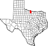
Town Unincorporated
communitiesBluegrove | Buffalo Springs | Halsell | Hurnville | Joy | Shannon | Stanfield | Thornberry | Vashti
Footnotes ‡This populated place also has portions in an adjacent county or counties
Categories:- Texas counties
- Clay County, Texas
- 1857 establishments in the United States
- Wichita Falls metropolitan area


Wikimedia Foundation. 2010.