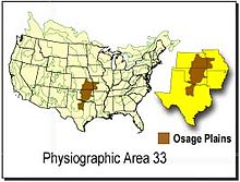
- Osage Plains
-
The Osage Plains are a physiographic section of the larger Central Lowland province, which in turn is part of the larger Interior Plains physiographic division.[1] The area is sometimes called the Lower Plains, North Central Plains, and the Rolling Plains.[2] The Osage Plains, covering west-central Missouri, the southeastern third of Kansas, most of central Oklahoma, and extending into north-central Texas, is the southernmost of three tallgrass prairie physiographic areas. It grades into savanna and woodland to the east and south, and into shorter mixed-grass prairie to the west. The Osage Plains consist of three subregions. The Osage Plains proper occupy the northeast segment. Although sharply demarcated from the Ozark uplift, the Plains are nonetheless a transitional area across which the boundary between prairie and woodland has shifted over time. In the central portion of the physiographic area lies the second subregion, the Flint Hills. This large remnant core of native tallgrass prairie is a rocky rolling terrain that run from north to south across Kansas and extends into Oklahoma. To the west and south of these hills are the Blackland Prairies and Cross Timbers. This vegetatively complex region of intermixed prairie and scrubby juniper-mesquite woodland extends into north-central Texas. Bluestem prairies and oak-dominated savannas and woodlands characterize the natural vegetation in the Cross Timbers. Much of the area has been converted to agriculture, although expanses of oak forest and woodland are still scattered throughout the eastern portion of the subregion.
Birds in the Osage Plains include the threatened Greater Prairie-Chicken, Henslow's Sparrow, Dickcissel, Loggerhead Shrike, Field Sparrow, Scissor-tailed Flycatcher, Bell's Vireo, Painted Bunting and Harris's Sparrow. Wildfire suppression, overgrazing and the spread of exotic plants are the factors most negatively affecting priority bird habitat. The area now is managed almost exclusively for beef production with annual burns and intensive grazing practices that provide little of the habitat structure required to support many priority bird species.
Historically, fire, drought, and Plains Bison were dominant ecological forces and had great influences on the vegetation from local to landscape scales. The Osage Plains and Flint Hills were dominated historically by tallgrass prairie with scattered groves of Blackjack Oak (Quercus marilandica) in the uplands and along drainages. A variety of wetland types, including wet prairie, marshes and northern floodplain forests occurred along larger rivers. Today, much of the land in the Osage Plains is planted to maize and soybeans, or has been converted to non-native grasses for pasture and hay. Large expanses of tallgrass prairie remain in the Flint Hills where relief is greater than in the Osage Plains subregion and the land less suitable for cropping.
Geology
The Osage Plains is underlain by soft shales with interbedded sandstones and limestones of late Mississippian to Pennsylvanian age. Some of the rocks prevalent in the Osage Plains are Mississippian limestone, limestone shale, Ordovician dolomite, and coal. There are also clay and shale within the Pennsylvanian bedrock.[3]
The area contained two major mining areas. The biggest was the Tri-State Lead and Zinc Region, consisting of nearly 2,000 sq mi (5,200 km2). This was the largest concentration of zinc deposits anywhere in the world. Most mining sites have closed, mainly due to health and other environmental issues, but more than $1 billion worth of lead and zinc were extracted from the area during the active mining days. The other major mining was for bituminous coal. But due to air quality standards, this region's coal is in low demand due to its high sulfur content.[4]
References
- ^ "Physiographic divisions of the conterminous U. S.". U.S. Geological Survey. http://water.usgs.gov/GIS/metadata/usgswrd/XML/physio.xml. Retrieved 2007-12-06.
- ^ "Osage Plains". Oklahoma Historical Society. http://digital.library.okstate.edu/encyclopedia/entries/O/OS007.html. Retrieved 2007-12-28.
- ^ Adamski, James C.; James C. Petersen, David A. Freiwald, and Jerri V. Davis (1995). Environmental and Hydrologic Setting of the Ozark Plateaus Study Unit, Arkansas, Kansas, Missouri, and Oklahoma. U.S. Geological Survey, Water-Resources Investigations Report 94-4022. p. 14. http://pubs.usgs.gov/wri/wri944022/WRIR94-4022.pdf.
- ^ Hudson, John C. (2002). Across This Land: A Regional Geography of the United States and Canada. JHU Press. pp. 134–135. ISBN 0801865670. http://books.google.com/books?id=FQUbfAWhh-oC&dq=%22osage+plains%22+geology.
Subfields of physical geography 
 State of Texas
Austin (capital) Topics Architecture · Climate · Geography · Government · History · Languages · Literature · Sports · Texans · Transportation · Symbols · Visitor Attractions
Society Regions Ark‑La‑Tex · Big Bend · Blackland Prairies · Brazos Valley · Central Texas · Coastal Bend · Cross Timbers · Deep East Texas · East Texas · Edwards Plateau · Golden Triangle · Hill Country · Llano Estacado · Northeast Texas · North Texas · Osage Plains · Panhandle · Permian Basin · Piney Woods · Rio Grande Valley · Southeast Texas · South Plains · South Texas · Trans-Pecos · West Texas
Metropolitan
areasAbilene · Amarillo · Austin–Round Rock–San Marcos · Beaumont–Port Arthur · Brownsville–Harlingen · College Station–Bryan · Corpus Christi · Dallas–Fort Worth–Arlington · El Paso · Houston–Sugar Land–Baytown · Killeen–Temple–Fort Hood · Laredo · Longview · Lubbock · McAllen–Edinburg–Mission · Midland · Odessa · San Angelo · San Antonio–New Braunfels · Sherman–Denison · Texarkana · Tyler · Victoria · Waco · Wichita Falls
Counties See: Table of Texas counties or List
 This article incorporates public domain material from the United States Government document "Osage Plains, Bureau of Land Management".Categories:
- Physiographic sections
- Temperate grasslands, savannas, and shrublands in the United States
- Ecoregions of the United States
- Grasslands of Texas
- Flora of the Plains-Midwest (United States)
- Regions of the Western United States
- Regions of Missouri
- Landforms of Missouri
- Landforms of Texas
- Landforms of Oklahoma
Wikimedia Foundation. 2010.

