- Osage County, Kansas
-
Osage County, Kansas 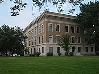 Osage County Courthouse in Lyndon
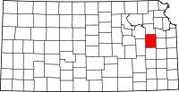
Location in the state of Kansas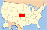
Kansas's location in the U.S.Founded 1859 Seat Lyndon Area
- Total
- Land
- Water
719.23 sq mi (1,863 km²)
703.50 sq mi (1,822 km²)
15.72 sq mi (41 km²), 2.19%Population
- (2010)
- Density
16,295
24.1/sq mi (9.3/km²)Time zone Central: UTC-6/-5 Website www.OsageCo.org Osage County (county code OS) is a county located in east-central Kansas, in the Central United States. As of the 2010 census, the county population was 16295.[1] Its county seat is Lyndon,[2] and its most populous city is Osage City. The county along with Shawnee, Jackson, Jefferson, and Wabaunsee counties is included in the Topeka, Kansas, Metropolitan Statistical Area. Osage was originally organized in 1855 as Weller County, and was renamed in 1859 after the Osage River that runs through it.[3]
Contents
Law and government
Osage County was a prohibition, or "dry", county until the Kansas Constitution was amended in 1986 and voters approved the sale of alcoholic liquor by the individual drink with a 30% food sales requirement.[4]
Geography
According to the 2000 census, the county has a total area of 719.23 square miles (1,862.8 km2), of which 703.50 square miles (1,822.1 km2) (or 97.81%) is land and 15.72 square miles (40.7 km2) (or 2.19%) is water.[5]
Adjacent counties
- Shawnee County (north)
- Douglas County (northeast)
- Franklin County (east)
- Coffey County (south)
- Lyon County (southwest)
- Wabaunsee County (northwest)
Demographics
Historical populations Census Pop. %± 1900 23,659 — 1910 19,905 −15.9% 1920 18,621 −6.5% 1930 17,538 −5.8% 1940 15,118 −13.8% 1950 12,811 −15.3% 1960 12,886 0.6% 1970 13,352 3.6% 1980 15,319 14.7% 1990 15,248 −0.5% 2000 16,712 9.6% 2010 16,295 −2.5% U.S. Decennial Census As of the U.S. Census in 2000,[6] there were 16,712 people, 6,490 households, and 4,737 families residing in the county. The population density was 24 people per square mile (9/km2). There were 7,018 housing units at an average density of 10 per square mile (4/km2). The racial makeup of the county was 97.27% White, 0.22% Black or African American, 0.65% Native American, 0.17% Asian, 0.10% Pacific Islander, 0.41% from other races, and 1.18% from two or more races. Hispanic or Latino of any race were 1.53% of the population.
There were 6,490 households out of which 33.80% had children under the age of 18 living with them, 61.00% were married couples living together, 8.10% had a female householder with no husband present, and 27.00% were non-families. 23.50% of all households were made up of individuals and 11.50% had someone living alone who was 65 years of age or older. The average household size was 2.54 and the average family size was 2.99.
In the county the population was spread out with 27.00% under the age of 18, 6.40% from 18 to 24, 27.00% from 25 to 44, 23.70% from 45 to 64, and 15.80% who were 65 years of age or older. The median age was 39 years. For every 100 females there were 96.00 males. For every 100 females age 18 and over, there were 93.30 males.
The median income for a household in the county was $37,928, and the median income for a family was $44,581. Males had a median income of $30,670 versus $22,981 for females. The per capita income for the county was $17,691. About 6.40% of families and 8.40% of the population were below the poverty line, including 8.40% of those under age 18 and 10.40% of those age 65 or over.
Cities and towns
Incorporated cities
Name and population (2006 estimate):[7]
- Osage City, 2,944
- Carbondale, 1,440
- Lyndon, 1,027 (county seat)
- Burlingame, 1,003
- Overbrook, 960
- Scranton, 701
- Quenemo, 447
- Melvern, 423
- Olivet, 64
Townships
Osage County is divided into sixteen townships. The city of Osage City is considered governmentally independent and is excluded from the census figures for the townships. In the following table, the population center is the largest city (or cities) included in that township's population total, if it is of a significant size.
Township FIPS Population
centerPopulation Population
density
/km² (/sq mi)Land area
km² (sq mi)Water area
km² (sq mi)Water % Geographic coordinates Agency 00450 Quenemo 618 7 (19) 86 (33) 0 (0) 0.10% 38°34′21″N 95°32′12″W / 38.5725°N 95.53667°W Arvonia 02550 136 1 (3) 112 (43) 13 (5) 10.13% 38°28′52″N 95°52′14″W / 38.48111°N 95.87056°W Barclay 04175 239 2 (5) 124 (48) 0 (0) 0.14% 38°33′42″N 95°52′0″W / 38.56167°N 95.866667°W Burlingame 09375 Burlingame 1,768 9 (25) 186 (72) 1 (0) 0.43% 38°47′5″N 95°52′5″W / 38.78472°N 95.86806°W Dragoon 18575 214 2 (6) 94 (36) 0 (0) 0.07% 38°43′14″N 95°49′16″W / 38.72056°N 95.82111°W Elk 20175 Overbrook 1,723 12 (32) 140 (54) 0 (0) 0.30% 38°47′21″N 95°33′58″W / 38.78917°N 95.56611°W Fairfax 22150 513 5 (12) 111 (43) 5 (2) 4.14% 38°42′34″N 95°40′3″W / 38.70944°N 95.6675°W Grant 27850 297 3 (8) 93 (36) 0 (0) 0.25% 38°38′25″N 95°52′24″W / 38.64028°N 95.87333°W Junction 35725 1,210 9 (24) 129 (50) 0 (0) 0.15% 38°40′27″N 95°34′8″W / 38.67417°N 95.56889°W Lincoln 40925 134 2 (4) 83 (32) 0 (0) 0.10% 38°29′7″N 95°33′17″W / 38.48528°N 95.55472°W Melvern 45725 Melvern 812 7 (18) 115 (44) 0 (0) 0.13% 38°30′8″N 95°38′50″W / 38.50222°N 95.64722°W Olivet 52725 Olivet 263 2 (5) 143 (55) 17 (7) 10.70% 38°29′53″N 95°44′51″W / 38.49806°N 95.7475°W Ridgeway 59825 Carbondale 2,661 25 (64) 108 (42) 2 (1) 2.00% 38°48′56″N 95°40′56″W / 38.81556°N 95.68222°W Scranton 63700 Scranton 1,273 14 (36) 92 (36) 1 (0) 0.91% 38°47′30″N 95°45′10″W / 38.79167°N 95.75278°W Superior 69500 293 3 (8) 93 (36) 0 (0) 0.30% 38°38′44″N 95°47′34″W / 38.64556°N 95.79278°W Valley Brook 73200 Lyndon 1,524 15 (38) 104 (40) 0 (0) 0.46% 38°36′44″N 95°40′35″W / 38.61222°N 95.67639°W Sources: "Census 2000 U.S. Gazetteer Files". U.S. Census Bureau, Geography Division. http://www.census.gov/geo/www/gazetteer/places2k.html. Education
 2005 KDOT Map of Osage County (map legend)
Unified school districts
- Osage City USD 420 (Web site)
- Lyndon USD 421 (Web site)
- Santa Fe Trail USD 434 (Web site)
- Burlingame USD 454 (Web site)
- Marais des Cygnes Valley USD 456 (Web site)
Media
Osage County is served by a weekly newspaper, The Osage County Herald-Chronicle (Web site). The newspaper has a circulation of approximately 4,500, making it the 3rd largest paid weekly publication in the state of Kansas.
The Herald-Chronicle was created by the merger of The Osage County Herald and The Osage County Chronicle in February 2007.
See also
Information on this and other counties in Kansas
- List of counties in Kansas
- National Register of Historic Places listings in Kansas
- Kansas locations by per capita income
Other information for Kansas
- List of cities in Kansas
- List of unified school districts in Kansas
- List of colleges and universities in Kansas
References
- ^ "2010 County Population and Housing Occupancy Status". U.S. Census Bureau. http://factfinder2.census.gov/faces/tableservices/jsf/pages/productview.xhtml?pid=DEC_10_PL_GCTPL2.ST05&prodType=table. Retrieved April 5, 2011.
- ^ "Find a County". National Association of Counties. http://www.naco.org/Counties/Pages/FindACounty.aspx. Retrieved 2011-06-07.
- ^ http://www.osage.kansasgov.com/MV2Base.asp?VarCN=18
- ^ "Map of Wet and Dry Counties". Alcoholic Beverage Control, Kansas Department of Revenue. November 2006. http://www.ksrevenue.org/abcwetdrymap.htm. Retrieved 2007-12-28.
- ^ "Census 2000 U.S. Gazetteer Files: Counties". United States Census. http://www.census.gov/tiger/tms/gazetteer/county2k.txt. Retrieved 2011-02-13.
- ^ "American FactFinder". United States Census Bureau. http://factfinder.census.gov. Retrieved 2008-01-31.
- ^ "Population Estimates". U.S. Census Bureau, Population Division. http://www.census.gov/popest/estimates.php. Annual estimates of the population to 2006-07-01. Released 2007-06-28.
Further reading
- History of the State of Kansas; William G. Cutler; A.T. Andreas Publisher; 1883. (Online HTML eBook)
- Kansas : A Cyclopedia of State History, Embracing Events, Institutions, Industries, Counties, Cities, Towns, Prominent Persons, Etc; 3 Volumes; Frank W. Blackmar; Standard Publishing Co; 944 / 955 / 824 pages; 1912. (Volume1 - Download 54MB PDF eBook),(Volume2 - Download 53MB PDF eBook), (Volume3 - Download 33MB PDF eBook)
External links
- Official sites
- Additional information
- Maps
- 2008 Osage County Map, KDOT
- 2011 Kansas Highway Map, KDOT
- 2011 Kansas Railroad Map, KDOT
- 2005 Kansas School District Boundary Map, KSDE

Wabaunsee County Shawnee County Douglas County 
 Osage County, Kansas

Lyon County Coffey County Franklin County Municipalities and communities of Osage County, Kansas Cities Burlingame | Carbondale | Lyndon | Melvern | Olivet | Osage City | Overbrook | Quenemo | Scranton

Township Agency
Unincorporated
communityVassar
Categories:- Kansas counties
- Osage County, Kansas
- 1859 establishments in the United States
- Topeka metropolitan area


Wikimedia Foundation. 2010.