- Cowley County, Kansas
-
Cowley County, Kansas 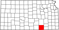
Location in the state of Kansas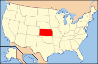
Kansas's location in the U.S.Founded February 26, 1867 Seat Winfield Area
- Total
- Land
- Water
1,132.60 sq mi (2,933 km²)
1,126.24 sq mi (2,917 km²)
6.37 sq mi (16 km²), 0.56%Population
- (2010)
- Density
36,311
31.0/sq mi (12.0/km²)Time zone Central: UTC-6/-5 Website CowleyCounty.org Cowley County (county code CL) is a county located in south-central Kansas, in the Central United States. As of the 2010 census, the county population was 36,311.[1] Its county seat and most populous city is Winfield.[2] The Winfield Micropolitan Statistical Area includes all of Cowley County.
Contents
History
19th century
First visited by the explorer DeSoto in 1537[3], Cowley County was officially organized as a county, but reserved for the Osage Indians, by the Kansas Legislature in March 1867, originally named Hunter County for Robert Mercer Taliaferro Hunter (1809–1887), a Virginia Representative and Senator to Congress and Speaker of the House in the twenty-sixth Congress. In 1870, the county was renamed for Matthew Cowley, First Lieutenant in Company I, 9th Kansas Cavalry, who died at Little Rock, Arkansas, on October 7, 1864. Officially opened for settlement July 15, 1870, there was a lengthy and bitter disagreement between the towns of Winfield and Cresswell (the town now named Arkansas City) over the possession of the county seat of government. Finally settled after two special elections and numerous petitions to the Governor and Legislature, Winfield was determined to be the county seat and a courthouse was constructed in 1873 at a cost of $11,500[4]
21st century
In 2010, the Keystone-Cushing Pipeline (Phase II) was constructed north to south through Cowley County, with much controversy over tax exemption and environmental concerns (if a leak ever occurs).[5][6] A pumping station named Rock was built.
Law and government
Following amendment to the Kansas Constitution in 1986, the county remained a prohibition, or "dry", county until 1996, when voters approved the sale of alcoholic liquor by the individual drink without a food sales requirement.[7]
Geography
According to the 2000 census, the county has a total area of 1,132.60 square miles (2,933.4 km2), of which 1,126.24 square miles (2,916.9 km2) (or 99.44%) is land and 6.37 square miles (16.5 km2) (or 0.56%) is water.[8]
Adjacent counties
- Butler County (north)
- Elk County (northeast)
- Chautauqua County (east)
- Osage County, Oklahoma (south)
- Kay County, Oklahoma (southwest)
- Sumner County (west)
- Sedgwick County (northwest)
Demographics
Historical populations Census Pop. %± 1860 158 — 1870 1,175 643.7% 1880 21,538 1,733.0% 1890 34,478 60.1% 1900 30,156 −12.5% 1910 31,790 5.4% 1920 35,155 10.6% 1930 40,903 16.4% 1940 38,139 −6.8% 1950 36,905 −3.2% 1960 37,861 2.6% 1970 35,012 −7.5% 1980 36,824 5.2% 1990 36,915 0.2% 2000 36,291 −1.7% 2010 36,311 0.1% U.S. Decennial Census 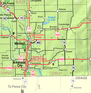
As of the U.S. Census in 2000,[9] there were 36,291 people, 14,039 households, and 9,616 families residing in the county. The population density was 32 people per square mile (12/km2). There were 15,673 housing units at an average density of 14 per square mile (5/km2). The racial makeup of the county was 90.13% White, 2.70% Black or African American, 1.96% Native American, 1.53% Asian, 0.01% Pacific Islander, 1.36% from other races, and 2.30% from two or more races. Hispanic or Latino of any race were 3.59% of the population.
There were 14,039 households out of which 32.20% had children under the age of 18 living with them, 55.20% were married couples living together, 9.60% had a female householder with no husband present, and 31.50% were non-families. 27.90% of all households were made up of individuals and 13.20% had someone living alone who was 65 years of age or older. The average household size was 2.46 and the average family size was 3.00.
In the county the population was spread out with 26.00% under the age of 18, 9.90% from 18 to 24, 26.00% from 25 to 44, 22.20% from 45 to 64, and 15.90% who were 65 years of age or older. The median age was 37 years. For every 100 females there were 95.70 males. For every 100 females age 18 and over, there were 94.20 males.
The median income for a household in the county was $34,406, and the median income for a family was $43,636. Males had a median income of $31,703 versus $21,341 for females. The per capita income for the county was $17,509. About 9.20% of families and 12.90% of the population were below the poverty line, including 17.00% of those under age 18 and 11.20% of those age 65 or over.
Cities and towns
Incorporated cities
Name and population (2006 estimate):[10]
- Winfield, 11,741 (county seat)
- Arkansas City, 11,416
- Udall, 763
- Burden, 546
- Parkerfield, 349
- Dexter, 346
- Atlanta, 247
- Geuda Springs, 201, of which only a small portion lies in the county, the majority of the area and population being in Sumner County
- Cambridge, 99
Unincorporated places
- Akron
- Albright
- Box
- Cameron City
- Dale (Seely)
- Eaton
- Eschs
- Floral
- Glengrouse
- Grand Summit
- Hackney
- Hooser
- Kellogg
- Maple City
- Moxham
- New Salem
- Otto
- Pleasant Valley
- Rainbow Bend
- Redbud
- Rock
- Silverdale
- Taussig
- Tisdale
- Vinton
- Wilmot
Townships
Cowley County is divided into twenty-five townships. The cities of Arkansas City and Winfield are considered governmentally independent and are excluded from the census figures for the townships. In the following table, the population center is the largest city (or cities) included in that township's population total, if it is of a significant size.
Township FIPS Population
centerPopulation Population
density
/km² (/sq mi)Land area
km² (sq mi)Water area
km² (sq mi)Water % Geographic coordinates Beaver 05025 244 3 (7) 92 (36) 2 (1) 1.91% 37°10′42″N 97°5′26″W / 37.17833°N 97.09056°W Bolton 07875 1,754 13 (33) 136 (53) 2 (1) 1.59% 37°3′1″N 97°4′0″W / 37.05028°N 97.066667°W Cedar 11250 44 0 (1) 119 (46) 1 (0) 0.45% 37°5′9″N 96°36′27″W / 37.08583°N 96.6075°W Creswell 16375 2,098 22 (56) 97 (38) 2 (1) 2.07% 37°4′42″N 97°1′3″W / 37.07833°N 97.0175°W Dexter 17950 506 3 (7) 185 (71) 0 (0) 0.19% 37°11′56″N 96°42′27″W / 37.19889°N 96.7075°W Fairview 22475 203 2 (6) 93 (36) 0 (0) 0.29% 37°21′22″N 96°58′50″W / 37.35611°N 96.98056°W Grant 27550 76 1 (2) 116 (45) 0 (0) 0.09% 37°3′49″N 96°41′3″W / 37.06361°N 96.68417°W Harvey 30525 117 1 (2) 162 (63) 0 (0) 0.24% 37°26′47″N 96°37′58″W / 37.44639°N 96.63278°W Liberty 39950 218 2 (5) 124 (48) 0 (0) 0.02% 37°9′3″N 96°50′31″W / 37.15083°N 96.84194°W Maple 44450 702 8 (20) 91 (35) 0 (0) 0 % 37°25′59″N 97°6′7″W / 37.43306°N 97.10194°W Ninnescah 50625 1,114 12 (31) 93 (36) 0 (0) 0.09% 37°21′59″N 97°6′21″W / 37.36639°N 97.10583°W Omnia 52850 357 4 (10) 93 (36) 0 (0) 0.22% 37°26′13″N 96°46′25″W / 37.43694°N 96.77361°W Otter 53625 54 0 (1) 135 (52) 1 (0) 0.68% 37°11′25″N 96°33′0″W / 37.19028°N 96.55°W Pleasant Valley 56500 838 7 (18) 117 (45) 0 (0) 0.05% 37°9′45″N 97°0′0″W / 37.1625°N 97°W Richland 59275 178 2 (4) 108 (42) 0 (0) 0 % 37°25′33″N 96°52′50″W / 37.42583°N 96.88056°W Rock Creek 60525 243 3 (7) 92 (35) 1 (0) 0.55% 37°26′5″N 96°59′25″W / 37.43472°N 96.99028°W Salem 62625 364 5 (14) 66 (26) 0 (0) 0.27% 37°20′9″N 96°53′20″W / 37.33583°N 96.88889°W Sheridan 64650 159 2 (4) 93 (36) 0 (0) 0.01% 37°15′44″N 96°45′51″W / 37.26222°N 96.76417°W Silver Creek 65500 770 8 (21) 93 (36) 0 (0) 0.27% 37°20′8″N 96°45′41″W / 37.33556°N 96.76139°W Silverdale 65575 327 2 (6) 136 (53) 0 (0) 0.31% 37°3′55″N 96°52′56″W / 37.06528°N 96.88222°W Spring Creek 67400 77 1 (2) 115 (45) 0 (0) 0.26% 37°4′31″N 96°47′10″W / 37.07528°N 96.78611°W Tisdale 70725 340 4 (11) 78 (30) 0 (0) 0.13% 37°16′6″N 96°52′25″W / 37.26833°N 96.87361°W Vernon 73575 502 5 (13) 102 (39) 1 (0) 0.67% 37°15′25″N 97°5′18″W / 37.25694°N 97.08833°W Walnut 74925 626 7 (18) 89 (34) 0 (0) 0.18% 37°15′17″N 96°57′27″W / 37.25472°N 96.9575°W Windsor 79875 211 1 (2) 243 (94) 0 (0) 0.18% 37°19′13″N 96°38′22″W / 37.32028°N 96.63944°W Sources: "Census 2000 U.S. Gazetteer Files". U.S. Census Bureau, Geography Division. http://www.census.gov/geo/www/gazetteer/places2k.html. Education
Unified school districts
Colleges
- Cowley College
- Southwestern College
- St. John's College closed in 1986
See also
Information on this and other counties in Kansas
- List of counties in Kansas
- National Register of Historic Places listings in Kansas
- Kansas locations by per capita income
Other information for Kansas
- List of cities in Kansas
- List of unified school districts in Kansas
- List of colleges and universities in Kansas
References
- ^ "2010 County Population and Housing Occupancy Status". U.S. Census Bureau. http://factfinder2.census.gov/faces/tableservices/jsf/pages/productview.xhtml?pid=DEC_10_PL_GCTPL2.ST05&prodType=table. Retrieved March 31, 2011.
- ^ "Find a County". National Association of Counties. http://www.naco.org/Counties/Pages/FindACounty.aspx. Retrieved 2011-06-07.
- ^ D. A. Millington and E. P. Greer, ”History of Cowley County Kansas”., Winfield Courier, January 1, 1901 Supplement
- ^ "William G. Cutler's, History of the State of Kansas". A. T. Andreas Press, 1883. http://www.kancoll.org/cutler/.
- ^ Keystone Pipeline - Marion County Commission calls out Legislative Leadership on Pipeline Deal; April 18, 2010.
- ^ Keystone Pipeline - TransCanada inspecting pipeline; December 10, 2010.
- ^ "Map of Wet and Dry Counties". Alcoholic Beverage Control, Kansas Department of Revenue. November 2006. http://www.ksrevenue.org/abcwetdrymap.htm. Retrieved 2007-12-28.
- ^ "Census 2000 U.S. Gazetteer Files: Counties". United States Census. http://www.census.gov/tiger/tms/gazetteer/county2k.txt. Retrieved 2011-02-13.
- ^ "American FactFinder". United States Census Bureau. http://factfinder.census.gov. Retrieved 2008-01-31.
- ^ "Population Estimates". U.S. Census Bureau, Population Division. http://www.census.gov/popest/estimates.php. Annual estimates of the population to 2006-07-01. Released 2007-06-28.
Further reading
- County
- History of Cowley County Kansas; D.A. Millington / E.P. Greer; Winfield Courier; 162 pages; 1901. (Download 16MB PDF eBook)
- Kansas
- History of the State of Kansas; William G. Cutler; A.T. Andreas Publisher; 1883. (Online HTML eBook)
- Kansas : A Cyclopedia of State History, Embracing Events, Institutions, Industries, Counties, Cities, Towns, Prominent Persons, Etc; 3 Volumes; Frank W. Blackmar; Standard Publishing Co; 944 / 955 / 824 pages; 1912. (Volume1 - Download 54MB PDF eBook), (Volume2 - Download 53MB PDF eBook), (Volume3 - Download 33MB PDF eBook)
External links
- County
- Cowley County - Official Website
- Cowley County - Directory of Public Officials
- Cowley County - Information, Skyways
- Historical
- Maps
- Cowley County Map, KDOT
- Kansas Highway Map, KDOT
- Kansas Railroad Map, KDOT
- Kansas School District Boundary Map, KSDE

Sedgwick County Butler County Elk County Sumner County 
Chautauqua County  Cowley County, Kansas

Kay County, Oklahoma Osage County, Oklahoma Municipalities and communities of Cowley County, Kansas Cities Arkansas City | Atlanta | Burden | Cambridge | Dexter | Geuda Springs‡ | Parkerfield | Udall | Winfield

Townships Beaver | Bolton | Cedar | Creswell | Dexter | Fairview | Grant | Harvey | Liberty | Maple | Ninnescah | Omnia | Otter | Pleasant Valley | Richland | Rock Creek | Salem | Sheridan | Silver Creek | Silverdale | Spring Creek | Tisdale | Vernon | Walnut | Windsor
Unincorporated
communitiesAkron | Hackney | Maple City | Rock | Silverdale | Tisdale
Footnotes ‡This populated place also has portions in an adjacent county or counties
Categories:- Kansas counties
- Cowley County, Kansas
- 1867 establishments


Wikimedia Foundation. 2010.