- Cloud County, Kansas
-
Cloud County, Kansas 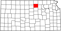
Location in the state of Kansas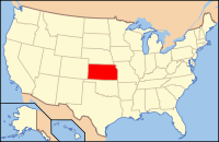
Kansas's location in the U.S.Founded March 27, 1867 Named for Colonel William F. Cloud Seat Concordia Area
- Total
- Land
- Water
718.47 sq mi (1,861 km²)
715.63 sq mi (1,853 km²)
2.84 sq mi (7 km²), 0.40%Population
- (2010)
- Density
9,533
13.4/sq mi (5.2/km²)Time zone Central: UTC-6/-5 Website CloudCountyKS.org Cloud County (county code CD) is a county located in North Central Kansas, in the Central United States. As of the 2010 census, the county population was 9,533.[1] Its county seat and most populous city is Concordia.[2]
Contents
History
19th century
Cloud county was originally named "Shirley" county, but was later renamed "Cloud" county in honor of Colonel William F. Cloud.[3]
Cloud County was formed from the existing Washington County, Kansas in a joint convention with Republic and Cloud counties. The county was legally organized on September 6, 1866 with Elk Creek designated as the temporary county seat.[4]
In 1887, Atchison, Topeka and Santa Fe Railway built a branch line from Neva (3 miles west of Strong City) to Superior, Nebraska. This branch line connected Strong City, Neva, Rockland, Diamond Springs, Burdick, Lost Springs, Jacobs, Hope, Navarre, Enterprise, Abilene, Talmage, Manchester, Longford, Oak Hill, Miltonvale, Aurora, Huscher, Concordia, Kackley, Courtland, Webber, Superior. At some point, the line from Neva to Lost Springs was pulled but the right of way has not been abandoned. This branch line was originally called "Strong City and Superior line" but later the name was shortened to the "Strong City line". In 1996, the Atchison, Topeka and Santa Fe Railway merged with Burlington Northern Railroad and renamed to the current BNSF Railway. Most locals still refer to this railroad as the "Santa Fe".
Law and government
Following amendment to the Kansas Constitution in 1986, the county remained a prohibition, or "dry", county until 1998, when voters approved the sale of alcoholic liquor by the individual drink with a 30% food sales requirement.[5]
Geography
According to the 2000 census, the county has a total area of 718.47 square miles (1,860.8 km2), of which 715.63 square miles (1,853.5 km2) (or 99.60%) is land and 2.84 square miles (7.4 km2) (or 0.40%) is water.[6]
Geographic features
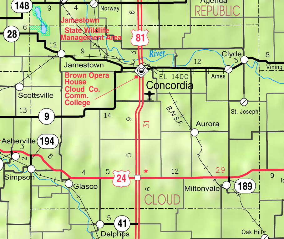
The Republican River passes through the county, entering from Republic County to the north and exiting to Clay County to the east. The Solomon River traverses the southwestern portion of the county, going from Mitchell County to Ottawa County. Jamestown Lake lies partially in the northwestern part of the county and partially in southwestern Republic county.
Major highways
Cloud County is bisected from north to south by U.S. Route 81, which runs through the town of Concordia and connects north to Belleville, Kansas or south to Salina, Kansas. The southern part of the county also has U.S. Route 24, connecting Clay Center, Kansas from the east and Beloit, Kansas to the west.
There are four other state highways in the county: K-9, K-28, K-189, and K-194.
Adjacent counties
- Republic County (north)
- Washington County (northeast)
- Clay County (east)
- Ottawa County (south)
- Mitchell County (west)
- Jewell County (northwest)
Demographics
Historical populations Census Pop. %± 1870 2,323 — 1880 15,343 560.5% 1890 19,295 25.8% 1900 18,071 −6.3% 1910 18,388 1.8% 1920 17,714 −3.7% 1930 18,006 1.6% 1940 17,247 −4.2% 1950 16,104 −6.6% 1960 14,407 −10.5% 1970 13,466 −6.5% 1980 12,494 −7.2% 1990 11,023 −11.8% 2000 10,268 −6.8% 2010 9,533 −7.2% U.S. Decennial Census 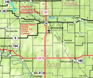 2005 KDOT Map of Cloud County (map legend)
As of the U.S. Census in 2000,[7] there were 10,268 people, 4,163 households, and 2,697 families residing in the county. The population density was 14 people per square mile (6/km²). There were 4,838 housing units at an average density of 7 per square mile (3/km²). The racial makeup of the county was 98.30% White, 0.34% Black or African American, 0.25% Native American, 0.25% Asian, 0.13% from other races, and 0.73% from two or more races. Hispanic or Latino of any race were 0.60% of the population.
There were 4,163 households out of which 27.10% had children under the age of 18 living with them, 55.10% were married couples living together, 6.60% had a female householder with no husband present, and 35.20% were non-families. 30.80% of all households were made up of individuals and 15.90% had someone living alone who was 65 years of age or older. The average household size was 2.31 and the average family size was 2.89.
In the county the population was spread out with 22.40% under the age of 18, 10.40% from 18 to 24, 21.90% from 25 to 44, 22.20% from 45 to 64, and 23.20% who were 65 years of age or older. The median age was 41 years. For every 100 females there were 90.60 males. For every 100 females age 18 and over, there were 86.60 males.
The median income for a household in the county was $31,758, and the median income for a family was $39,745. Males had a median income of $27,166 versus $20,114 for females. The per capita income for the county was $17,536. About 6.40% of families and 10.80% of the population were below the poverty line, including 12.10% of those under age 18 and 8.70% of those age 65 or over.
Cities and towns
Incorporated cities
Name and population (2006 estimate):[8]
- Concordia, 5,281 (county seat)
- Clyde, 696
- Glasco, 496
- Miltonvale, 478
- Jamestown, 383
- Simpson, 100, of which only a small portion lies in the county, the majority of the area and population being in Mitchell County
- Aurora, 76
Unincorporated places
- Ames
- Como
- Cook
- Cool
- Hannum
- Hollis
- Huscher
- Lawrenceburg
- Macyville
- Meredith
- Minersville
- Nelson
- Oneonta
- Princeville
- Rice
- Rosaco
- Saint Joseph
- Sibley
- Sulphur Springs
- Yuma
Townships
Cloud County is divided into eighteen townships. The city of Concordia is considered governmentally independent and is excluded from the census figures for the townships. In the following table, the population center is the largest city (or cities) included in that township's population total, if it is of a significant size.
Township FIPS Population
centerPopulation Population
density
/km² (/sq mi)Land area
km² (sq mi)Water area
km² (sq mi)Water % Geographic coordinates Arion 02275 105 1 (3) 94 (36) 0 (0) 0.06% 39°28′28″N 97°44′42″W / 39.47444°N 97.745°W Aurora 03450 169 2 (5) 94 (36) 0 (0) 0.03% 39°26′27″N 97°32′2″W / 39.44083°N 97.53389°W Buffalo 09100 119 1 (3) 112 (43) 1 (0) 0.46% 39°35′12″N 97°45′13″W / 39.58667°N 97.75361°W Center 11625 172 1 (3) 141 (54) 0 (0) 0 % 39°26′51″N 97°38′45″W / 39.4475°N 97.64583°W Colfax 14775 49 1 (1) 93 (36) 0 (0) 0.05% 39°26′6″N 97°25′19″W / 39.435°N 97.42194°W Elk 20150 845 12 (30) 72 (28) 1 (0) 1.08% 39°35′51″N 97°24′16″W / 39.5975°N 97.40444°W Grant 27525 479 5 (14) 92 (35) 2 (1) 1.75% 39°36′6″N 97°52′7″W / 39.60167°N 97.86861°W Lawrence 38875 146 2 (4) 93 (36) 1 (0) 1.22% 39°36′18″N 97°32′41″W / 39.605°N 97.54472°W Lincoln 40525 378 6 (16) 61 (24) 1 (0) 1.21% 39°33′20″N 97°39′5″W / 39.55556°N 97.65139°W Lyon 43425 103 1 (2) 142 (55) 0 (0) 0.02% 39°22′2″N 97°46′20″W / 39.36722°N 97.77222°W Meredith 45925 77 1 (2) 94 (36) 0 (0) 0.03% 39°21′1″N 97°38′53″W / 39.35028°N 97.64806°W Nelson 49600 137 2 (4) 91 (35) 0 (0) 0 % 39°30′55″N 97°31′36″W / 39.51528°N 97.52667°W Oakland 51750 52 1 (1) 93 (36) 0 (0) 0.15% 39°21′44″N 97°31′44″W / 39.36222°N 97.52889°W Shirley 65375 178 2 (4) 110 (42) 1 (0) 0.60% 39°32′47″N 97°26′5″W / 39.54639°N 97.43472°W Sibley 65425 178 2 (5) 92 (35) 1 (1) 1.45% 39°36′54″N 97°42′5″W / 39.615°N 97.70139°W Solomon 66250 664 5 (12) 141 (54) 0 (0) 0 % 39°21′49″N 97°51′34″W / 39.36361°N 97.85944°W Starr 68050 653 7 (18) 92 (36) 0 (0) 0.21% 39°20′52″N 97°26′42″W / 39.34778°N 97.445°W Summit 69050 50 0 (1) 139 (54) 0 (0) 0 % 39°30′11″N 97°51′59″W / 39.50306°N 97.86639°W Sources: "Census 2000 U.S. Gazetteer Files". U.S. Census Bureau, Geography Division. http://www.census.gov/geo/www/gazetteer/places2k.html. Education
Unified school districts
Colleges and Universities
- Historic
- Miltonvale Wesleyan College (closed 1972)
- Concordia Normal School (closed 1876)
- Concordia Business College (closed sometime after 1930)
See also
Information on this and other counties in Kansas
- List of counties in Kansas
- National Register of Historic Places listings in Kansas
- Kansas locations by per capita income
Other information for Kansas
- List of cities in Kansas
- List of unified school districts in Kansas
- List of colleges and universities in Kansas
References
- ^ "2010 County Population and Housing Occupancy Status". U.S. Census Bureau. http://factfinder2.census.gov/faces/tableservices/jsf/pages/productview.xhtml?pid=DEC_10_PL_GCTPL2.ST05&prodType=table. Retrieved March 31, 2011.
- ^ "Find a County". National Association of Counties. http://www.naco.org/Counties/Pages/FindACounty.aspx. Retrieved 2011-06-07.
- ^ Kansas Skyways "Cloud County History"
- ^ History of the State of Kansas by William G. Cutler, Kansas Collection of Books
- ^ "Map of Wet and Dry Counties". Alcoholic Beverage Control, Kansas Department of Revenue. November 2006. http://www.ksrevenue.org/abcwetdrymap.htm. Retrieved 2007-12-26.
- ^ "Census 2000 U.S. Gazetteer Files: Counties". United States Census. http://www.census.gov/tiger/tms/gazetteer/county2k.txt. Retrieved 2011-02-13.
- ^ "American FactFinder". United States Census Bureau. http://factfinder.census.gov. Retrieved 2008-01-31.
- ^ "Population Estimates". U.S. Census Bureau, Population Division. http://www.census.gov/popest/estimates.php. Annual estimates of the population to 2006-07-01. Released 2007-06-28.
Further reading
- History of the State of Kansas; William G. Cutler; A.T. Andreas Publisher; 1883. (Online HTML eBook)
- Kansas : A Cyclopedia of State History, Embracing Events, Institutions, Industries, Counties, Cities, Towns, Prominent Persons, Etc; 3 Volumes; Frank W. Blackmar; Standard Publishing Co; 944 / 955 / 824 pages; 1912. (Volume1 - Download 54MB PDF eBook),(Volume2 - Download 53MB PDF eBook), (Volume3 - Download 33MB PDF eBook)
External links
- County
- Cloud County - Official Website
- Cloud County - Directory of Public Officials
- Cloud County - Information, Skyways
- Maps
- Cloud County Map, KDOT
- Kansas Highway Map, KDOT
- Kansas Railroad Map, KDOT
- Kansas School District Boundary Map, KSDE

Jewell County Republic County Washington County Mitchell County 
Clay County  Cloud County, Kansas

Ottawa County Cloud County, Kansas history Locations
ListPeople Charles H. Blosser • Napoleon Bonaparte Brown • Henry Buckingham • Frank Carlson • Boston Corbett • May Louise Cowles • James Manney Hagaman • Pop Hollinger • Ernest C. Quigley
Organizations Concordia Normal School • Roman Catholic Diocese of Concordia, Kansas
Municipalities and communities of Cloud County, Kansas Cities 
Townships Unincorporated
communitiesFootnotes ‡This populated place also has portions in an adjacent county or counties
Categories:- Kansas counties
- Cloud County, Kansas
- 1867 establishments


Wikimedia Foundation. 2010.