- Marshall County, Kansas
-
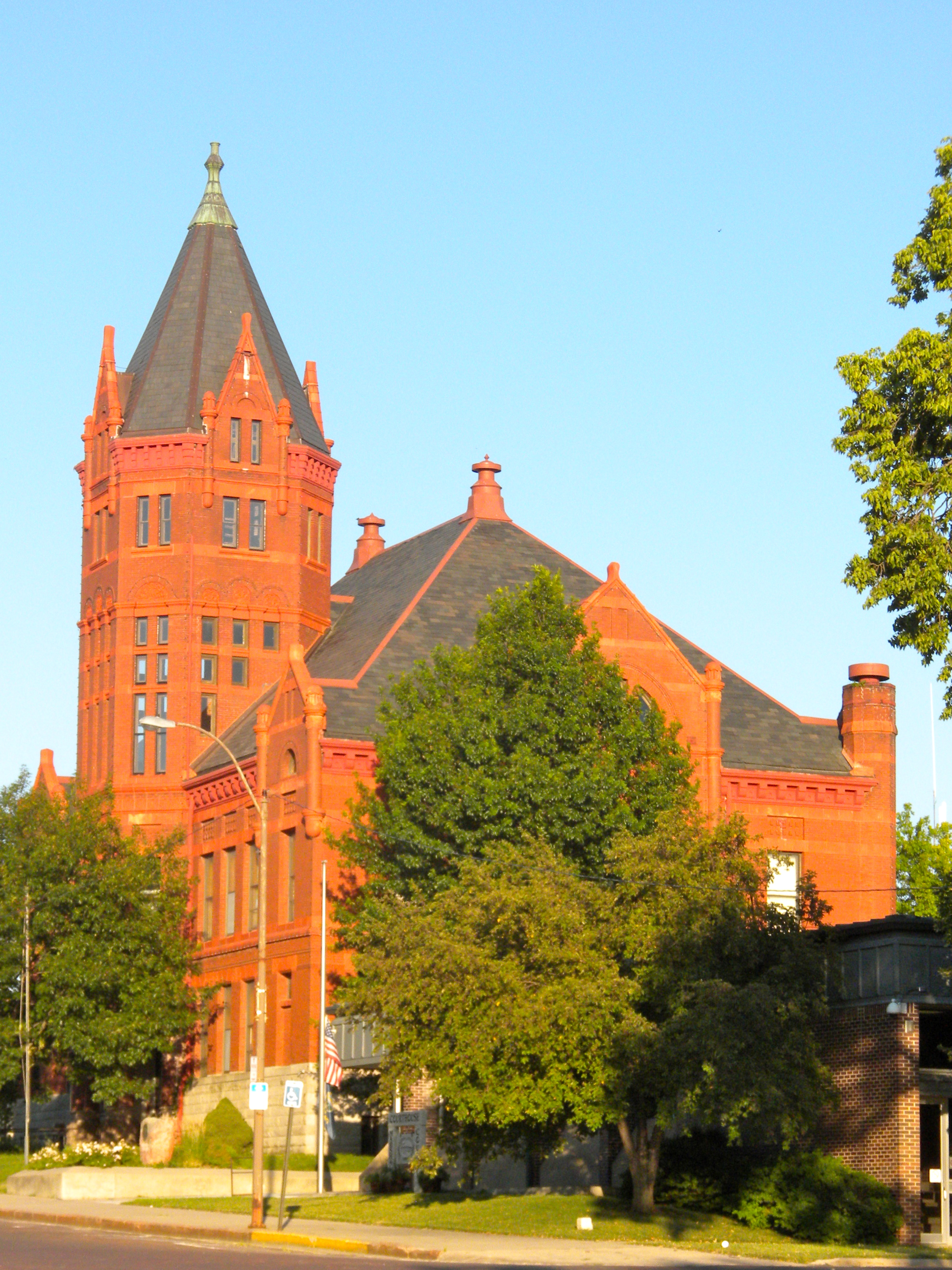
Marshall County, Kansas  Marshall County Courthouse
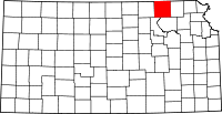
Location in the state of Kansas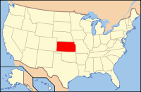
Kansas's location in the U.S.Founded August 25, 1855 Seat Marysville Area
- Total
- Land
- Water
904.36 sq mi (2,342 km²)
902.53 sq mi (2,338 km²)
1.83 sq mi (5 km²), 0.20%Population
- (2010)
- Density
10,117
11.5/sq mi (4.5/km²)Time zone Central: UTC-6/-5 Marshall County (standard abbreviation: MS) is a county located in the U.S. state of Kansas. As of the 2010 census, the county population was 10,117.[1] The largest city and county seat is Marysville.
Contents
History
On May 30, 1879, the "Irving, Kansas Tornado" passed through Marshall county. This tornado measured F4 on the Fujita scale and had a damage path 800 yards (730 m) wide and 100 miles (160 km) long. Eighteen people were killed and sixty were injured.[citation needed]
Law and government
Marshall County was a prohibition, or "dry", county until the Kansas Constitution was amended in 1986 and voters approved the sale of alcoholic liquor by the individual drink with a 30% food sales requirement.[2]
Geography
According to the 2000 census, the county has a total area of 904.36 square miles (2,342.3 km2), of which 902.53 square miles (2,337.5 km2) (or 99.80%) is land and 1.83 square miles (4.7 km2) (or 0.20%) is water.[3]
Adjacent counties
- Pawnee County, Nebraska (northeast)
- Nemaha County (east)
- Pottawatomie County (south)
- Riley County (southwest)
- Washington County (west)
- Gage County, Nebraska (northwest)
Demographics
 The Irving stone marker southeast of Blue Rapids.
Historical populations Census Pop. %± 1900 24,355 — 1910 23,880 −2.0% 1920 22,730 −4.8% 1930 23,056 1.4% 1940 20,986 −9.0% 1950 17,926 −14.6% 1960 15,598 −13.0% 1970 13,139 −15.8% 1980 12,787 −2.7% 1990 11,705 −8.5% 2000 10,965 −6.3% 2010 10,117 −7.7% U.S. Decennial Census As of the census[4] of 2000, there were 10,965 people, 4,458 households, and 3,026 families residing in the county. The population density was 12 people per square mile (5/km²). There were 4,999 housing units at an average density of 6 per square mile (2/km²). The racial makeup of the county was 98.14% White, 0.23% Black or African American, 0.36% Native American, 0.19% Asian, 0.02% Pacific Islander, 0.26% from other races, and 0.80% from two or more races. 0.76% of the population were Hispanic or Latino of any race.
There were 4,458 households out of which 30.20% had children under the age of 18 living with them, 59.70% were married couples living together, 5.40% had a female householder with no husband present, and 32.10% were non-families. 29.50% of all households were made up of individuals and 17.00% had someone living alone who was 65 years of age or older. The average household size was 2.40 and the average family size was 2.98.
In the county the population was spread out with 25.00% under the age of 18, 6.60% from 18 to 24, 23.60% from 25 to 44, 22.80% from 45 to 64, and 22.00% who were 65 years of age or older. The median age was 42 years. For every 100 females there were 96.80 males. For every 100 females age 18 and over, there were 94.00 males.
The median income for a household in the county was $32,089, and the median income for a family was $39,705. Males had a median income of $28,361 versus $19,006 for females. The per capita income for the county was $17,090. About 6.40% of families and 9.20% of the population were below the poverty line, including 9.60% of those under age 18 and 9.10% of those age 65 or over.
Cities and towns
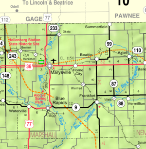 2005 KDOT Map of Marshall County (map legend)
Incorporated cities
Name and population (2004 estimate):
- Marysville, 3,065
- Blue Rapids, 1,046
- Frankfort, 797
- Waterville, 628
- Axtell, 432
- Beattie, 267
- Summerfield, 203
- Vermillion, 99
- Oketo, 84
Unincorporated communities
Ghost towns
- Irving
Townships
Marshall County is divided into twenty-five townships. The city of Marysville is considered governmentally independent and is excluded from the census figures for the townships. In the following table, the population center is the largest city (or cities) included in that township's population total, if it is of a significant size.
Sources: 2000 U.S. Gazetteer from the U.S. Census Bureau. Township FIPS Population
centerPopulation Population
density
/km² (/sq mi)Land area
km² (sq mi)Water area
km² (sq mi)Water % Geographic coordinates Balderson 03850 106 1 (3) 98 (38) 0 (0) 0.09% 39°57′39″N 96°30′39″W / 39.96083°N 96.51083°W Bigelow 06725 66 1 (2) 97 (37) 1 (0) 0.96% 39°36′36″N 96°31′56″W / 39.61°N 96.53222°W Blue Rapids 07675 78 1 (2) 93 (36) 0 (0) 0.23% 39°37′17″N 96°37′28″W / 39.62139°N 96.62444°W Blue Rapids City 07700 1,201 13 (34) 92 (36) 1 (0) 0.98% 39°41′6″N 96°39′19″W / 39.685°N 96.65528°W Center 11850 151 2 (4) 98 (38) 0 (0) 0 % 39°47′14″N 96°30′51″W / 39.78722°N 96.51417°W Clear Fork 13875 54 1 (2) 93 (36) 0 (0) 0.02% 39°36′58″N 96°23′55″W / 39.61611°N 96.39861°W Cleveland 14100 91 1 (3) 92 (36) 1 (0) 1.02% 39°36′43″N 96°17′47″W / 39.61194°N 96.29639°W Cottage Hill 15850 143 2 (4) 93 (36) 0 (0) 0.03% 39°36′10″N 96°45′34″W / 39.60278°N 96.75944°W Elm Creek 20600 178 2 (5) 93 (36) 0 (0) 0.02% 39°46′57″N 96°37′52″W / 39.7825°N 96.63111°W Franklin 24450 337 3 (9) 98 (38) 0 (0) 0.06% 39°51′47″N 96°31′46″W / 39.86306°N 96.52944°W Guittard 29225 454 5 (13) 93 (36) 0 (0) 0.03% 39°51′52″N 96°24′53″W / 39.86444°N 96.41472°W Herkimer 31450 234 3 (7) 92 (36) 0 (0) 0.02% 39°57′44″N 96°45′2″W / 39.96222°N 96.75056°W Lincoln 40850 130 1 (4) 92 (35) 0 (0) 0.36% 39°46′56″N 96°17′27″W / 39.78222°N 96.29083°W Logan 41975 335 4 (9) 93 (36) 0 (0) 0 % 39°53′14″N 96°45′8″W / 39.88722°N 96.75222°W Marysville 45075 383 5 (12) 84 (32) 0 (0) 0 % 39°51′36″N 96°38′42″W / 39.86°N 96.645°W Murray 49275 640 7 (18) 92 (36) 0 (0) 0.14% 39°52′28″N 96°16′17″W / 39.87444°N 96.27139°W Noble 50850 217 2 (6) 92 (35) 1 (0) 0.83% 39°42′45″N 96°17′6″W / 39.7125°N 96.285°W Oketo 52550 251 3 (7) 92 (35) 0 (0) 0 % 39°57′11″N 96°37′32″W / 39.95306°N 96.62556°W Richland 59450 206 2 (6) 93 (36) 0 (0) 0 % 39°57′54″N 96°23′55″W / 39.965°N 96.39861°W Rock 60425 123 1 (3) 93 (36) 0 (0) 0.09% 39°47′2″N 96°24′45″W / 39.78389°N 96.4125°W St. Bridget 62100 232 3 (7) 92 (35) 0 (0) 0.05% 39°57′53″N 96°19′28″W / 39.96472°N 96.32444°W Vermillion 73550 1,012 11 (28) 93 (36) 0 (0) 0.07% 39°42′12″N 96°24′48″W / 39.70333°N 96.41333°W Walnut 75025 144 2 (4) 93 (36) 0 (0) 0 % 39°47′28″N 96°44′45″W / 39.79111°N 96.74583°W Waterville 75975 797 9 (22) 93 (36) 0 (0) 0.03% 39°41′44″N 96°45′8″W / 39.69556°N 96.75222°W Wells 76525 131 1 (3) 98 (38) 0 (0) 0 % 39°41′13″N 96°30′39″W / 39.68694°N 96.51083°W Education
Unified school districts
- Historical
- Axtell USD 488 (Marshall County) and Sabetha USD 441 (Nemaha County) consolidated to create Prairie Hills USD 113.[5]
Trivia
- The township of Franklin has produced one Major League Baseball player...pitcher Frank Wayenberg. (b. August 27, 1898)
- The township of Herkimer has produced one Major League Baseball player...outfielder Butch Nieman. (b. February 8, 1918)
- The township of Walnut has produced one Major League Baseball player...pitcher Don Songer. (b. January 31, 1899)
See also
Information on this and other counties in Kansas
- List of counties in Kansas
- National Register of Historic Places listings in Kansas
- Kansas locations by per capita income
Other information for Kansas
- List of cities in Kansas
- List of unified school districts in Kansas
- List of colleges and universities in Kansas
References
- ^ "2010 County Population and Housing Occupancy Status". U.S. Census Bureau. http://factfinder2.census.gov/faces/tableservices/jsf/pages/productview.xhtml?pid=DEC_10_PL_GCTPL2.ST05&prodType=table. Retrieved March 31, 2011.
- ^ "Map of Wet and Dry Counties". Alcoholic Beverage Control, Kansas Department of Revenue. November 2006. http://www.ksrevenue.org/abcwetdrymap.htm. Retrieved 2007-12-28.
- ^ "Census 2000 U.S. Gazetteer Files: Counties". United States Census. http://www.census.gov/tiger/tms/gazetteer/county2k.txt. Retrieved 2011-02-13.
- ^ "American FactFinder". United States Census Bureau. http://factfinder.census.gov. Retrieved 2008-01-31.
- ^ School consolidations in Kansas for past decade; Topeka-Capital Journal; July 24, 2011.
Further reading
- History of the State of Kansas; William G. Cutler; A.T. Andreas Publisher; 1883. (Online HTML eBook)
- Kansas : A Cyclopedia of State History, Embracing Events, Institutions, Industries, Counties, Cities, Towns, Prominent Persons, Etc; 3 Volumes; Frank W. Blackmar; Standard Publishing Co; 944 / 955 / 824 pages; 1912. (Volume1 - Download 54MB PDF eBook),(Volume2 - Download 53MB PDF eBook), (Volume3 - Download 33MB PDF eBook)
External links
- County
- Marshall County
- Marshall County - Information, Blue Skyways
- Tornados
- Maps
- Marshall County Map, KDOT
- Kansas Highway Map, KDOT
- Kansas Railroad Map, KDOT
- Kansas School District Boundary Map, KSDE

Gage County, Nebraska Pawnee County, Nebraska Washington County 
Nemaha County  Marshall County, Kansas

Riley County Pottawatomie County Municipalities and communities of Marshall County, Kansas Cities Axtell | Beattie | Blue Rapids | Frankfort | Marysville | Oketo | Summerfield | Vermillion | Waterville

Townships Balderson | Bigelow | Blue Rapids | Blue Rapids City | Center | Clear Fork | Cleveland | Cottage Hill | Elm Creek | Franklin | Guittard | Herkimer | Lincoln | Logan | Marysville | Murray | Noble | Oketo | Richland | Rock | St. Bridget | Vermillion | Walnut | Waterville | Wells
Unincorporated
communitiesGhost towns Bigelow | Irving
Categories:- Kansas counties
- Marshall County, Kansas
- 1855 establishments in the United States


Wikimedia Foundation. 2010.