- Meade County, Kansas
-
Meade County, Kansas 
Location in the state of Kansas
Kansas's location in the U.S.Founded March 20, 1873 Seat Meade Area
- Total
- Land
- Water
979.66 sq mi (2,537 km²)
978.42 sq mi (2,534 km²)
1.24 sq mi (3 km²), 0.13%Population
- (2010)
- Density
4,575
4.7/sq mi (1.8/km²)Time zone Central: UTC-6/-5 Website www.MeadeCo.org Meade County (standard abbreviation: ME) is a county located in the U.S. state of Kansas. It is named in honor of General George G. Meade. As of the 2010 census, the county population was 4,575.[1] The largest city and county seat is Meade.
Contents
Law and government
Although the Kansas Constitution was amended in 1986 to allow the sale of alcoholic liquor by the individual drink with the approval of voters, Meade County has remained a prohibition, or "dry", county.[2]
Geography
According to the 2000 census, the county has a total area of 979.66 square miles (2,537.3 km2), of which 978.42 square miles (2,534.1 km2) (or 99.87%) is land and 1.24 square miles (3.2 km2) (or 0.13%) is water.[3]
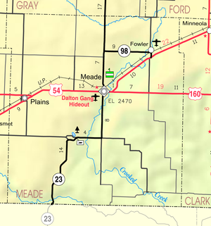
Adjacent counties
- Gray County (north)
- Ford County (northeast)
- Clark County (east)
- Beaver County, Oklahoma (south)
- Seward County (west)
- Haskell County (northwest)
Demographics
Historical populations Census Pop. %± 1900 1,581 — 1910 5,055 219.7% 1920 5,542 9.6% 1930 6,858 23.7% 1940 5,522 −19.5% 1950 5,710 3.4% 1960 5,505 −3.6% 1970 4,912 −10.8% 1980 4,788 −2.5% 1990 4,247 −11.3% 2000 4,631 9.0% 2010 4,575 −1.2% U.S. Decennial Census 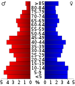 Age pyramid
As of the census[4] of 2000, there were 4,631 people, 1,728 households, and 1,252 families residing in the county. The population density was 5 people per square mile (2/km²). There were 1,968 housing units at an average density of 2 per square mile (1/km²). The racial makeup of the county was 91.10% White, 0.39% Black or African American, 0.54% Native American, 0.22% Asian, 6.24% from other races, and 1.51% from two or more races. 10.90% of the population were Hispanic or Latino of any race.
There were 1,728 households out of which 36.40% had children under the age of 18 living with them, 64.70% were married couples living together, 4.90% had a female householder with no husband present, and 27.50% were non-families. 25.60% of all households were made up of individuals and 13.60% had someone living alone who was 65 years of age or older. The average household size was 2.61 and the average family size was 3.16.
In the county the population was spread out with 29.50% under the age of 18, 6.90% from 18 to 24, 26.50% from 25 to 44, 19.20% from 45 to 64, and 17.90% who were 65 years of age or older. The median age was 36 years. For every 100 females there were 98.20 males. For every 100 females age 18 and over, there were 95.00 males.
The median income for a household in the county was $36,761, and the median income for a family was $41,550. Males had a median income of $29,295 versus $20,153 for females. The per capita income for the county was $16,824. About 6.70% of families and 9.30% of the population were below the poverty line, including 11.90% of those under age 18 and 5.70% of those age 65 or over.
Cities and towns
Incorporated cities
Name and population (2004 estimate):
Townships
Meade County is divided into nine townships. None of the cities within the county are considered governmentally independent, and all figures for the townships include those of the cities. In the following table, the population center is the largest city (or cities) included in that township's population total, if it is of a significant size.
Sources: 2000 U.S. Gazetteer from the U.S. Census Bureau. Township FIPS Population
centerPopulation Population
density
/km² (/sq mi)Land area
km² (sq mi)Water area
km² (sq mi)Water % Geographic coordinates Cimarron 13325 93 0 (1) 303 (117) 2 (1) 0.57% 37°4′34″N 100°30′42″W / 37.07611°N 100.51167°W Crooked Creek 16450 92 1 (2) 141 (54) 0 (0) 0.06% 37°24′41″N 100°19′30″W / 37.41139°N 100.325°W Fowler 24200 749 3 (7) 271 (105) 0 (0) 0.01% 37°23′8″N 100°11′46″W / 37.38556°N 100.19611°W Logan 42000 100 0 (1) 284 (110) 0 (0) 0.01% 37°14′30″N 100°11′58″W / 37.24167°N 100.19944°W Meade Center 45350 1,968 7 (18) 280 (108) 0 (0) 0.14% 37°16′15″N 100°20′15″W / 37.27083°N 100.3375°W Mertilla 46025 221 1 (1) 389 (150) 0 (0) 0.02% 37°24′33″N 100°30′58″W / 37.40917°N 100.51611°W Odee 52075 50 0 (1) 246 (95) 0 (0) 0.13% 37°2′47″N 100°22′14″W / 37.04639°N 100.37056°W Sand Creek 62925 38 0 (0) 272 (105) 0 (0) 0.03% 37°3′59″N 100°9′46″W / 37.06639°N 100.16278°W West Plains 77300 1,320 4 (10) 348 (134) 0 (0) 0.13% 37°14′59″N 100°33′45″W / 37.24972°N 100.5625°W Education
Unified school districts
See also
- Dry counties
- National Register of Historic Places listings in Meade County, Kansas
Information on this and other counties in Kansas
- List of counties in Kansas
- National Register of Historic Places listings in Kansas
- Kansas locations by per capita income
Other information for Kansas
- List of cities in Kansas
- List of unified school districts in Kansas
- List of colleges and universities in Kansas
References
- ^ "2010 County Population and Housing Occupancy Status". U.S. Census Bureau. http://factfinder2.census.gov/faces/tableservices/jsf/pages/productview.xhtml?pid=DEC_10_PL_GCTPL2.ST05&prodType=table. Retrieved March 31, 2011.
- ^ "Map of Wet and Dry Counties". Alcoholic Beverage Control, Kansas Department of Revenue. November 2004. http://www.ksrevenue.org/abcwetdrymap.htm. Retrieved 2007-01-21.
- ^ "Census 2000 U.S. Gazetteer Files: Counties". United States Census. http://www.census.gov/tiger/tms/gazetteer/county2k.txt. Retrieved 2011-02-13.
- ^ "American FactFinder". United States Census Bureau. http://factfinder.census.gov. Retrieved 2008-01-31.
Further reading
- History of the State of Kansas; William G. Cutler; A.T. Andreas Publisher; 1883. (Online HTML eBook)
- Kansas : A Cyclopedia of State History, Embracing Events, Institutions, Industries, Counties, Cities, Towns, Prominent Persons, Etc; 3 Volumes; Frank W. Blackmar; Standard Publishing Co; 944 / 955 / 824 pages; 1912. (Volume1 - Download 54MB PDF eBook),(Volume2 - Download 53MB PDF eBook), (Volume3 - Download 33MB PDF eBook)
External links
- Official
- General county information
- County Level Data
- Maps
- Meade County Map, KDOT
- Kansas Highway Map, KDOT
- Kansas Railroad Map, KDOT
- Kansas School District Boundary Map, KSDE

Haskell County Gray County Ford County Seward County 
Clark County  Meade County, Kansas

Beaver County, Oklahoma Beaver County, Oklahoma Harper County, Oklahoma Municipalities and communities of Meade County, Kansas Cities  Categories:
- Kansas counties
- Meade County, Kansas
- 1873 establishments


Wikimedia Foundation. 2010.