- Jefferson County, Kansas
-
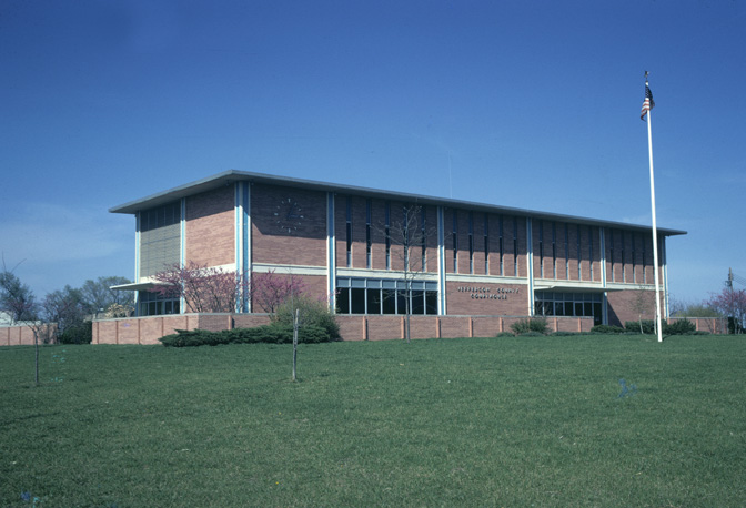
Jefferson County, Kansas 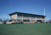 Jefferson County Courthouse in Oskaloosa
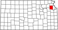
Location in the state of Kansas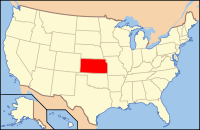
Kansas's location in the U.S.Founded August 25, 1855 Seat Oskaloosa Area
- Total
- Land
- Water
556.94 sq mi (1,442 km²)
536.11 sq mi (1,389 km²)
20.83 sq mi (54 km²), 3.74%Population
- (2010)
- Density
19,126
35.2/sq mi (13.6/km²)Time zone Central: UTC-6/-5 Website www.jfcountyks.com Jefferson County (county code JF) is a county located in Northeast Kansas, in the Central United States. As of the 2010 census, the county population was 19,126.[1] Its county seat is Oskaloosa, and its most populous city is Valley Falls.[2] The county along with Shawnee, Jackson, Osage, and Wabaunsee counties is included in the Topeka, Kansas, Metropolitan Statistical Area.
Contents
History
Settlement of the county was slowed by events prior to and during the Civil War, but the present day unincorporated community of Thompsonville (3 miles northwest of Perry on the Delaware River) was the first established in 1851 by Mormon settlers who initially refused to accompany the main group led by Brigham Young to the Salt Lake Valley. The settlement was first abandoned due to the violence resulting from the border wars, but was re-established when the Civil War ended.[citation needed]
Law and government
Jefferson County was a prohibition, or "dry", county until the Kansas Constitution was amended in 1986 and voters approved the sale of alcoholic liquor by the individual drink with a 30% food sales requirement.[3]
Geography
According to the 2000 census, the county has a total area of 556.94 square miles (1,442.5 km2), of which 536.11 square miles (1,388.5 km2) (or 96.26%) is land and 20.83 square miles (53.9 km2) (or 3.74%) is water.[4]
Adjacent counties
- Atchison County (north)
- Leavenworth County (east)
- Douglas County (south)
- Shawnee County (southwest)
- Jackson County (northwest)
Demographics
Historical populations Census Pop. %± 1900 17,533 — 1910 15,826 −9.7% 1920 14,750 −6.8% 1930 14,129 −4.2% 1940 12,718 −10.0% 1950 11,084 −12.8% 1960 11,252 1.5% 1970 11,945 6.2% 1980 15,207 27.3% 1990 15,905 4.6% 2000 18,426 15.9% 2010 19,126 3.8% U.S. Decennial Census 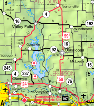
As of the U.S. Census in 2000,[5] there were 18,426 people, 6,830 households, and 5,190 families residing in the county. The population density was 34 people per square mile (13/km²). There were 7,491 housing units at an average density of 14 per square mile (5/km²). The racial makeup of the county was 96.70% White, 0.92% Native American, 0.37% Black or African American, 0.17% Asian, 0.01% Pacific Islander, 0.42% from other races, and 1.41% from two or more races. Hispanic or Latino of any race were 1.28% of the population.
There were 6,830 households out of which 35.70% had children under the age of 18 living with them, 65.20% were married couples living together, 7.00% had a female householder with no husband present, and 24.00% were non-families. 20.10% of all households were made up of individuals and 9.30% had someone living alone who was 65 years of age or older. The average household size was 2.66 and the average family size was 3.07.
In the county the population was spread out with 27.40% under the age of 18, 7.00% from 18 to 24, 28.00% from 25 to 44, 24.90% from 45 to 64, and 12.80% who were 65 years of age or older. The median age was 38 years. For every 100 females there were 102.60 males. For every 100 females age 18 and over, there were 98.90 males.
The median income for a household in the county was $45,535, and the median income for a family was $50,557. Males had a median income of $36,174 versus $25,468 for females. The per capita income for the county was $19,373. About 5.30% of families and 6.70% of the population were below the poverty line, including 6.90% of those under age 18 and 7.70% of those age 65 or over.
Cities and towns
Incorporated cities
Name and population (2006 estimate):
- Valley Falls, 1,190
- Oskaloosa, 1,127 (county seat)
- Perry, 884
- McLouth, 832
- Meriden, 713
- Nortonville, 590
- Winchester, 570
- Ozawkie, 567
Unincorporated communities
- Grantville
- Lakeside Village
- Mooney Creek
- Newman
- Rock Creek
- Thompsonville
- Williamstown
Townships
Jefferson County is divided into twelve townships. None of the cities within the county are considered governmentally independent, and all figures for the townships include those of the cities. In the following table, the population center is the largest city (or cities) included in that township's population total, if it is of a significant size.
Education
Unified school districts
- USD 338 - Valley Falls
- USD 339 - Jefferson County North
- USD 340 - Jefferson West
- USD 341 - Oskaloosa
- USD 342 - McLouth
- USD 343 - Perry-Lecompton
See also
Information on this and other counties in Kansas
- List of counties in Kansas
- National Register of Historic Places listings in Kansas
- Kansas locations by per capita income
Other information for Kansas
- List of cities in Kansas
- List of unified school districts in Kansas
- List of colleges and universities in Kansas
References
- ^ "2010 County Population and Housing Occupancy Status". U.S. Census Bureau. http://factfinder2.census.gov/faces/tableservices/jsf/pages/productview.xhtml?pid=DEC_10_PL_GCTPL2.ST05&prodType=table. Retrieved March 31, 2011.
- ^ "Find a County". National Association of Counties. http://www.naco.org/Counties/Pages/FindACounty.aspx. Retrieved 2011-06-07.
- ^ "Map of Wet and Dry Counties". Alcoholic Beverage Control, Kansas Department of Revenue. November 2006. http://www.ksrevenue.org/abcwetdrymap.htm. Retrieved 2007-12-28.
- ^ "Census 2000 U.S. Gazetteer Files: Counties". United States Census. http://www.census.gov/tiger/tms/gazetteer/county2k.txt. Retrieved 2011-02-13.
- ^ "American FactFinder". United States Census Bureau. http://factfinder.census.gov. Retrieved 2008-01-31.
Further reading
- History of the State of Kansas; William G. Cutler; A.T. Andreas Publisher; 1883. (Online HTML eBook)
- Kansas : A Cyclopedia of State History, Embracing Events, Institutions, Industries, Counties, Cities, Towns, Prominent Persons, Etc; 3 Volumes; Frank W. Blackmar; Standard Publishing Co; 944 / 955 / 824 pages; 1912. (Volume1 - Download 54MB PDF eBook),(Volume2 - Download 53MB PDF eBook), (Volume3 - Download 33MB PDF eBook)
External links
- Official sites
- Additional information
- Maps
- Jefferson County Map, KDOT
- Kansas Highway Map, KDOT
- Kansas Railroad Map, KDOT
- Kansas School District Boundary Map, KSDE

Jackson County Atchison County 
Leavenworth County  Jefferson County, Kansas

Shawnee County Douglas County Municipalities and communities of Jefferson County, Kansas Cities McLouth | Meriden | Nortonville | Oskaloosa | Ozawkie | Perry | Valley Falls | Winchester
Townships Unincorporated
communitiesDunavant | Grantville | Half Mound | Lakeside Village | Mooney Creek | Newman | Rock Creek | Thompsonville | Williamstown
Categories:- Kansas counties
- 1855 establishments in the United States
- Jefferson County, Kansas
- Topeka metropolitan area


Wikimedia Foundation. 2010.