- Montgomery County, Kansas
-
Montgomery County, Kansas 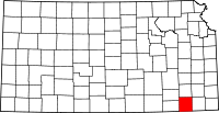
Location in the state of Kansas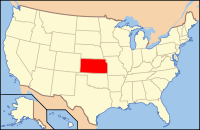
Kansas's location in the U.S.Founded February 26, 1867 Named for Richard Montgomery Seat Independence Area
- Total
- Land
- Water
651.40 sq mi (1,687 km²)
645.20 sq mi (1,671 km²)
6.19 sq mi (16 km²), 0.95%Population
- (2010)
- Density
35,471
53.8/sq mi (20.8/km²)Time zone Central: UTC-6/-5 Website www.MgCountyKS.org Montgomery County (county code MG) is a county located in southeast Kansas, in the Central United States. As of the 2010 census, the county population was 35,471.[1] Its county seat is Independence,[2] and its most populous city is Coffeyville. The Coffeyville Micropolitan Statistical Area includes all of Montgomery County.
Contents
History
Montgomery County was established February 26, 1867. It was named in honor of Richard Montgomery, an American Revolutionary War general killed in 1775 while attempting to capture Quebec City, in Canada, after successfully capturing two forts and the city of Montreal.[citation needed]
When Kansas was admitted to the Union as a state in 1861, the Osage Indian reservation occupied a large tract of land near the southern border. The reservation had been established in 1825. After the Civil War ended, the Osage lands were coveted as the largest and last reserve of good land in the eastern part of the state. As early as 1866, the Osages were forced to cede tracts at the eastern and northern edges of the reservation. This treaty conceded white settlement on land in the eastern part of what is now Montgomery County.[citation needed]
For a brief time, the Osages attempted to maintain a boundary at the Verdigris River. The Verdigris flows from north to south through the center of Montgomery County. From the west the Elk River joins the Verdigris at a confluence slightly northwest of the geographical center of the county. In 1867 Frank and Fred Bunker established a primitive cattle camp on the west side of the Verdigris south of the confluence. Like the Osages, the Bunkers thought they were beyond the boundaries of civilization.[citation needed]
Early in 1869, however, settlers began to cross the Verdigris River, "at first under protest of the Indians, but the immense throng of settlers soon made all protests futile." Montgomery County was surveyed and organized in 1869; the governor appointed commissioners June 3.[citation needed]
Law and government
Following amendment to the Kansas Constitution in 1986, the county remained a prohibition, or "dry", county until 1998, when voters approved the sale of alcoholic liquor by the individual drink without a food sales requirement.[3]
Geography
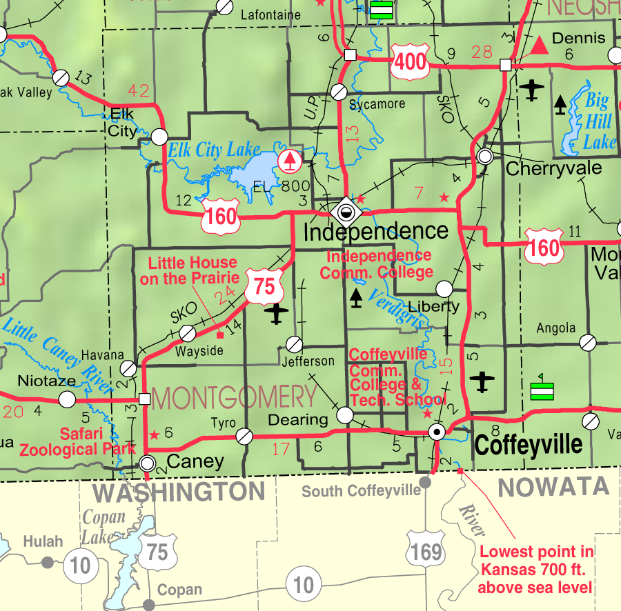
According to the 2000 census, the county has a total area of 651.40 square miles (1,687.1 km2), of which 645.20 square miles (1,671.1 km2) (or 99.05%) is land and 6.19 square miles (16.0 km2) (or 0.95%) is water.[4] The lowest point in the state of Kansas is located on the Verdigris River in Cherokee Township in Montgomery County (just southeast of Coffeyville), where it flows out of Kansas and into Oklahoma.
- Airports
- Coffeyville Municipal Airport, Independence Municipal Airport
- Bodies of water
- Elk City Lake, Elk River, Havana Lake, Liberty Lakes, State Lake, Verdigris River
- Highways
- U.S. Route 75, U.S. Route 160, U.S. Route 166, U.S. Route 169, U.S. Route 400
- State parks
- Elk City State Park, Montgomery County State Park
Adjacent counties
- Wilson County (north)
- Neosho County (northeast)
- Labette County (east)
- Nowata County, Oklahoma (southeast)
- Washington County, Oklahoma (south)
- Chautauqua County (west)
- Elk County (northwest)
Demographics
Historical populations Census Pop. %± 1900 29,039 — 1910 49,474 70.4% 1920 49,645 0.3% 1930 51,411 3.6% 1940 49,729 −3.3% 1950 46,487 −6.5% 1960 45,007 −3.2% 1970 39,949 −11.2% 1980 42,281 5.8% 1990 38,816 −8.2% 2000 36,252 −6.6% 2010 35,471 −2.2% U.S. Decennial Census 
As of the U.S. Census in 2000,[5] there were 36,252 people, 14,903 households, and 9,955 families residing in the county. The population density was 56 people per square mile (22/km2). There were 17,207 housing units at an average density of 27 per square mile (10/km2). The racial makeup of the county was 85.77% White, 6.07% Black or African American, 3.19% Native American, 0.47% Asian, 0.02% Pacific Islander, 1.13% from other races, and 3.34% from two or more races. Hispanic or Latino of any race were 3.08% of the population.
There were 14,903 households out of which 29.80% had children under the age of 18 living with them, 53.00% were married couples living together, 10.10% had a female householder with no husband present, and 33.20% were non-families. 29.70% of all households were made up of individuals and 14.70% had someone living alone who was 65 years of age or older. The average household size was 2.37 and the average family size was 2.93.
In the county the population was spread out with 25.00% under the age of 18, 8.60% from 18 to 24, 24.70% from 25 to 44, 23.30% from 45 to 64, and 18.30% who were 65 years of age or older. The median age was 39 years. For every 100 females there were 93.20 males. For every 100 females age 18 and over, there were 88.60 males.
The median income for a household in the county was $30,997, and the median income for a family was $38,516. Males had a median income of $29,745 versus $20,179 for females. The per capita income for the county was $16,421. About 9.20% of families and 12.60% of the population were below the poverty line, including 16.80% of those under age 18 and 10.90% of those age 65 or over.
Cities and towns
Incorporated cities
Name and population (2006 estimate):[6]
- Coffeyville, 10,387
- Independence, 9,317 (county seat)
- Cherryvale, 2,271
- Caney, 1,994
- Dearing, 453
- Elk City, 300
- Tyro, 223
- Liberty, 94
- Havana, 85
Unincorporated places
- Avian
- Blake
- Bolton
- Corbin
- Jefferson
- Le Hunt
- Sycamore
- Videtta Spur
- Wayside
Townships
Montgomery County is divided into twelve townships. The cities of Caney, Cherryvale, Coffeyville, and Independence are considered governmentally independent and are excluded from the census figures for the townships. In the following table, the population center is the largest city (or cities) included in that township's population total, if it is of a significant size.
Township FIPS Population
centerPopulation Population
density
/km² (/sq mi)Land area
km² (sq mi)Water area
km² (sq mi)Water % Geographic coordinates Caney 10400 1,244 7 (18) 176 (68) 1 (0) 0.30% 37°3′44″N 95°54′12″W / 37.06222°N 95.90333°W Cherokee 12850 541 5 (14) 100 (39) 0 (0) 0 % 37°3′40″N 95°34′50″W / 37.06111°N 95.58056°W Cherry 12875 517 5 (13) 103 (40) 0 (0) 0.10% 37°19′12″N 95°33′57″W / 37.32°N 95.56583°W Drum Creek 18700 537 6 (15) 92 (35) 0 (0) 0.15% 37°13′31″N 95°36′17″W / 37.22528°N 95.60472°W Fawn Creek 23325 2,036 11 (30) 179 (69) 0 (0) 0.06% 37°3′22″N 95°44′7″W / 37.05611°N 95.73528°W Independence 33900 2,342 14 (37) 163 (63) 5 (2) 2.85% 37°11′22″N 95°44′31″W / 37.18944°N 95.74194°W Liberty 40275 473 4 (11) 113 (44) 0 (0) 0.19% 37°9′32″N 95°35′59″W / 37.15889°N 95.59972°W Louisburg 42900 629 3 (9) 185 (71) 1 (1) 0.75% 37°18′25″N 95°53′56″W / 37.30694°N 95.89889°W Parker 54525 1,212 18 (47) 66 (26) 0 (0) 0.37% 37°3′19″N 95°37′55″W / 37.05528°N 95.63194°W Rutland 61925 302 2 (4) 185 (71) 2 (1) 0.86% 37°11′25″N 95°52′59″W / 37.19028°N 95.88306°W Sycamore 69750 835 5 (13) 169 (65) 7 (3) 3.86% 37°18′28″N 95°44′53″W / 37.30778°N 95.74806°W West Cherry 76825 239 2 (6) 102 (39) 0 (0) 0.05% 37°18′29″N 95°38′54″W / 37.30806°N 95.64833°W Sources: "Census 2000 U.S. Gazetteer Files". U.S. Census Bureau, Geography Division. http://www.census.gov/geo/www/gazetteer/places2k.html. Education
Unified school districts
- Caney Valley USD 436 (Web site)
- Cherryvale USD 447 (Web site)
- Coffeyville USD 445 (Web site)
- Independence USD 446 (Web site)
Colleges and universities
See also
Information on this and other counties in Kansas
- List of counties in Kansas
- National Register of Historic Places listings in Kansas
- Kansas locations by per capita income
Other information for Kansas
- List of cities in Kansas
- List of unified school districts in Kansas
- List of colleges and universities in Kansas
References
- ^ "2010 County Population and Housing Occupancy Status". U.S. Census Bureau. http://factfinder2.census.gov/faces/tableservices/jsf/pages/productview.xhtml?pid=DEC_10_PL_GCTPL2.ST05&prodType=table. Retrieved March 31, 2011.
- ^ "Find a County". National Association of Counties. http://www.naco.org/Counties/Pages/FindACounty.aspx. Retrieved 2011-06-07.
- ^ "Map of Wet and Dry Counties". Alcoholic Beverage Control, Kansas Department of Revenue. November 2006. http://www.ksrevenue.org/abcwetdrymap.htm. Retrieved 2007-12-28.
- ^ "Census 2000 U.S. Gazetteer Files: Counties". United States Census. http://www.census.gov/tiger/tms/gazetteer/county2k.txt. Retrieved 2011-02-13.
- ^ "American FactFinder". United States Census Bureau. http://factfinder.census.gov. Retrieved 2008-01-31.
- ^ "Population Estimates". U.S. Census Bureau, Population Division. http://www.census.gov/popest/estimates.php. Annual estimates of the population to 2006-07-01. Released 2007-06-28.
Further reading
- History of the State of Kansas; William G. Cutler; A.T. Andreas Publisher; 1883. (Online HTML eBook)
- Kansas : A Cyclopedia of State History, Embracing Events, Institutions, Industries, Counties, Cities, Towns, Prominent Persons, Etc; 3 Volumes; Frank W. Blackmar; Standard Publishing Co; 944 / 955 / 824 pages; 1912. (Volume1 - Download 54MB PDF eBook),(Volume2 - Download 53MB PDF eBook), (Volume3 - Download 33MB PDF eBook)
External links
- County
- Montgomery County - Official Website
- Montgomery County - Directory of Public Officials
- Montgomery County - Information, Skyways
- Maps
- Montgomery County Map, KDOT
- Kansas Highway Map, KDOT
- Kansas Railroad Map, KDOT
- Kansas School District Boundary Map, KSDE

Elk County Wilson County Neosho County Chautauqua County 
Labette County  Montgomery County, Kansas

Washington County, Oklahoma Nowata County, Oklahoma Municipalities and communities of Montgomery County, Kansas Cities Caney | Cherryvale | Coffeyville | Dearing | Elk City | Havana | Independence | Liberty | Tyro

Unincorporated
communityCategories:- Kansas counties
- Montgomery County, Kansas
- 1867 establishments


Wikimedia Foundation. 2010.