- Coffeyville Municipal Airport
-
Coordinates: 37°05′39″N 095°34′19″W / 37.09417°N 95.57194°W
Coffeyville Municipal Airport 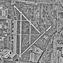
IATA: CFV – ICAO: KCFV – FAA LID: CFV Summary Airport type Public Owner City of Coffeyville Serves Coffeyville, Kansas Location Cherokee Township, Montgomery County, near Coffeyville, Kansas Elevation AMSL 754 ft / 230 m Runways Direction Length Surface ft m 17/35 5,872 1,790 Asphalt 4/22 4,000 1,219 Asphalt Statistics (2005) Aircraft operations 5,550 Based aircraft 40 Source: Federal Aviation Administration[1] 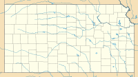
 Coffeyville MAPLocation of Coffeyville Municipal Airport, Kansas
Coffeyville Municipal Airport (IATA: CFV, ICAO: KCFV, FAA LID: CFV) is a city-owned public-use airport located four miles (6 km) northeast of the central business district of Coffeyville, a city in Montgomery County, Kansas, United States.[1]
Contents
History
During World War II, the facility was known as Coffeyville Army Airfield and was used as a United States Army Air Forces AAF Flying Training Command training field from 1942 though 1945. The 366th Army Air Force Base Unit (366th AAFBU) was the host unit at the airfield which performed Basic Pilot School instruction for aviation cadets.
Aircraft operated were Vultee BT-13A Valiants, BT-14s and BT-15s. The difference being that the BT-14 and BT-15 had more powerful engines. The BT-13 was the basic trainer flown by most pilots during World War II. It was the second phase of the three phase training program for pilots.
Coffeyville AAF also operated 4 auxiliary airfields in the area. The facility was closed and turned over to civil authorities at the end of the war and it was turned into a civil airport.
Facilities and aircraft
Coffeyville Municipal Airport covers an area of 1,227 acres (497 ha) which contains two asphalt paved runways: 17/35 measuring 5,872 x 100 ft (1,790 x 30 m) and 4/22 measuring 4,000 x 75 ft (1,219 x 23 m).[1]
For the 12-month period ending September 19, 2005, the airport had 5,550 aircraft operations, an average of 15 per day: 99% general aviation and 1% military. At that time there were 40 aircraft based at this airport: 85% single-engine, 10% multi-engine and 5% ultralight.[1]
See also
References
 This article incorporates public domain material from websites or documents of the Air Force Historical Research Agency.
- Shaw, Frederick J. (2004), Locating Air Force Base Sites History’s Legacy, Air Force History and Museums Program, United States Air Force, Washington DC, 2004.
- Manning, Thomas A. (2005), History of Air Education and Training Command, 1942–2002. Office of History and Research, Headquarters, AETC, Randolph AFB, Texas ASIN: B000NYX3PC
External links
- Resources for this airport:
- AirNav airport information for KCFV
- ASN accident history for CFV
- FlightAware airport information and live flight tracker
- NOAA/NWS latest weather observations
- SkyVector aeronautical chart, Terminal Procedures for KCFV
 Army Air Forces Training Command
Flying Training Flying Schools Eastern Flying Training Command · Central Flying Training Command · Western Flying Training CommandSpecialized Schools Bombardier · Contract Flying · Glider Training · Gunnery · Navigator
Technical Training Eastern Technical Training Command · Central Technical Training Command · Western Technical Training CommandCategories:- 1942 establishments
- USAAF Gulf Coast Training Center
- Airports in Kansas
- Buildings and structures in Montgomery County, Kansas
- Airfields of the United States Army Air Forces in Kansas
- Kansas airport stubs
- Kansas building and structure stubs


Wikimedia Foundation. 2010.