- List of counties in Kansas
-

This is a listing of counties in the U.S. state of Kansas. Select from the links at right to go directly to an article, or browse the listing below for additional information.
Kansas has 105 counties, the sixth-highest total of any state. Every license plate issued by the state contains the abbreviation for the county in which its vehicle is registered. No Kansas county has two words in its name. Wyandotte County and the city of Kansas City operate as a unified government, and Greeley County and the city of Tribune are in the process of converting to a similar system.
Contents
Alphabetical list
County FIPS code
[1]County seat
[2]Established
[2]Origin Etymology
[3]County Code Population
[2]Area
[2]Map Allen County 001 Iola 1855 One of the original 36 counties William Allen, U.S. Senator from Ohio and prominent supporter of westward expansion AL 14,385 503 sq mi
(1,303 km2)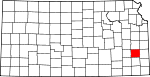
Anderson County 003 Garnett 1855 One of the original 36 counties Joseph C. Anderson, Kansas territorial legislator and Border Ruffian during "Bleeding Kansas" AN 8,110 583 sq mi
(1,510 km2)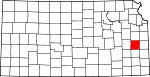
Atchison County 005 Atchison 1855 One of the original 36 counties David Rice Atchison, U.S. Senator from Missouri and Border Ruffian during "Bleeding Kansas" AT 16,774 432 sq mi
(1,119 km2)
Barber County 007 Medicine Lodge 1867 From unorganized area Thomas W. Barber, prominent Free-Stater killed in the Wakarusa War BA 5,307 1,134 sq mi
(2,937 km2)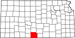
Barton County 009 Great Bend 1867 From unorganized area Clara Barton, founder of the American Red Cross BT 28,205 894 sq mi
(2,315 km2)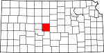
Bourbon County 011 Fort Scott 1855 One of the original 36 counties Bourbon County, Kentucky, from which many original settlers hailed BB 15,379 637 sq mi
(1,650 km2)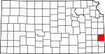
Brown County 013 Hiawatha 1855 One of the original 36 counties (Formerly Browne County) Albert Gallatin Brown, U.S. Senator from Mississippi and Kansas statehood advocate BR 10,724 571 sq mi
(1,479 km2)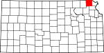
Butler County 015 El Dorado 1855 One of the original 36 counties Andrew Pickens Butler, U.S. Senator from South Carolina and Kansas statehood advocate BU 59,482 1,428 sq mi
(3,699 km2)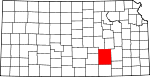
Chase County 017 Cottonwood Falls 1859 Formed from Butler and Wise counties Salmon Portland Chase, U.S. Senator from Ohio and Kansas statehood advocate CS 3,030 776 sq mi
(2,010 km2)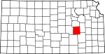
Chautauqua County 019 Sedan 1875 Formed from Howard County Chautauqua County, New York, from which many early settlers hailed CQ 4,359 642 sq mi
(1,663 km2)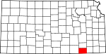
Cherokee County 021 Columbus 1855 One of the original 36 counties (Formerly McGee County) Cherokee Native Americans, whose lands borders the county in nearby Indian Territory CK 22,605 587 sq mi
(1,520 km2)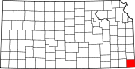
Cheyenne County 023 Saint Francis 1873 From unorganized area Cheyenne Native Americans, who inhabited the area CN 3,165 1,020 sq mi
(2,642 km2)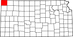
Clark County 025 Ashland 1885 Formed from Ford County Charles F. Clarke, Captain in 6th Regiment Kansas Volunteer Cavalry during American Civil War[4] CA 2,390 975 sq mi
(2,525 km2)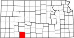
Clay County 027 Clay Center 1857 From unorganized area Henry Clay, influential U.S. Senator from Kentucky CY 8,822 644 sq mi
(1,668 km2)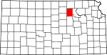
Cloud County 029 Concordia 1866 Formed from Washington (Formerly Shirley County) William F. Cloud, Union general in the American Civil War who chiefly fought in Kansas and Missouri CD 10,268 716 sq mi
(1,854 km2)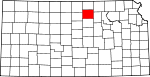
Coffey County 031 Burlington 1855 One of the original 36 counties A.M. Coffey, territorial legislator and Free-Stater during Bleeding Kansas CF 8,865 630 sq mi
(1,632 km2)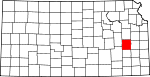
Comanche County 033 Coldwater 1867 From unorganized area Comanche Native Americans, who lived in the area CM 1,967 788 sq mi
(2,041 km2)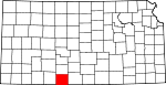
Cowley County 035 Winfield 1867 Formed from Butler County Matthew R. Cowley, Union lieutenant and distinguished Civil War hero CL 36,291 1,126 sq mi
(2,916 km2)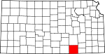
Crawford County 037 Girard 1867 Bourbon and Cherokee Counties Samuel J. Crawford, third Governor of Kansas CR 38,242 593 sq mi
(1,536 km2)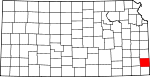
Decatur County 039 Oberlin 1873 From unorganized area Stephen Decatur, naval commodore and War of 1812 hero DC 3,472 894 sq mi
(2,315 km2)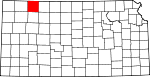
Dickinson County 041 Abilene 1857 From unorganized area Daniel Stevens Dickinson, U.S. Senator from New York and Kansas statehood advocate DK 19,344 848 sq mi
(2,196 km2)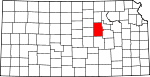
Doniphan County 043 Troy 1855 One of the original 36 counties Alexander William Doniphan, Mexican-American War hero and pro-slavery sympathizer in "Bleeding Kansas" DP 8,249 392 sq mi
(1,015 km2)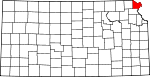
Douglas County 045 Lawrence 1855 One of the original 36 counties Stephen Arnold Douglas, U.S. Senator from Illinois and advocate for the moderate popular sovereignty choice in the Kansas slavery debate DG 99,962 457 sq mi
(1,184 km2)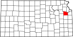
Edwards County 047 Kinsley 1874 Formed from Kiowa County John H. Edwards, state senator who pushed for creation of the county ED 3,449 622 sq mi
(1,611 km2)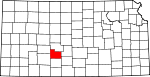
Elk County 049 Howard 1875 Formed from Howard County Elk River, which originates in the county EK 3,261 648 sq mi
(1,678 km2)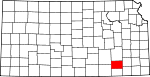
Ellis County 051 Hays 1867 From unorganized area George Ellis, Union lieutenant and distinguished Civil War hero EL 27,507 900 sq mi
(2,331 km2)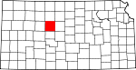
Ellsworth County 053 Ellsworth 1867 From unorganized area Fort Ellsworth, a Union Civil War outpost in the area EW 6,525 716 sq mi
(1,854 km2)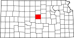
Finney County 055 Garden City 1883 Formed from Arapahoe, Grant, Kearney and Sequoyah Counties David W. Finney, tenth lieutenant governor of Kansas FI 40,523 1,300 sq mi
(3,367 km2)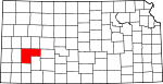
Ford County 057 Dodge City 1867 From unorganized area James H. Ford, Union general in the Civil War who mainly fought in Kansas and Missouri FO 32,458 1,099 sq mi
(2,846 km2)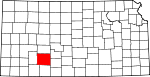
Franklin County 059 Ottawa 1855 One of the original 36 counties Benjamin Franklin, orator, writer, scholar, and founding father of the U.S. FR 24,784 574 sq mi
(1,487 km2)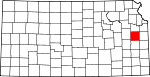
Geary County 061 Junction City 1855 One of the original 36 counties (Formerly Davis County) John White Geary, Union general in the Civil War who mainly fought in Kansas and Missouri, and who later became Kansas territorial governor GE 27,947 384 sq mi
(995 km2)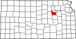
Gove County 063 Gove City 1868 From unorganized area Grenville L. Gove, Captain in the 11th Regiment Kansas Volunteer Cavalry during the Civil War[5] GO 3,068 1,072 sq mi
(2,776 km2)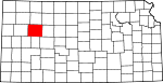
Graham County 065 Hill City 1867 From unorganized area John L. Graham, Union captain and Civil War hero GH 2,946 898 sq mi
(2,326 km2)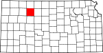
Grant County 067 Ulysses 1888 Formed from Finney and Hamilton Counties Ulysses Simpson Grant, commander of Union forces during the Civil War and U.S. President GT 7,909 575 sq mi
(1,489 km2)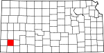
Gray County 069 Cimarron 1887 Formed from Finney and Ford Counties Alfred Gray, Kansas Secretary of Agriculture GY 5,904 869 sq mi
(2,251 km2)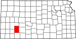
Greeley County 071 Tribune 1873 From unorganized area Horace Greeley, publisher of the New York Tribune and anti-slavery advocate GL 1,534 778 sq mi
(2,015 km2)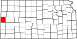
Greenwood County 073 Eureka 1855 One of the original 36 counties Alfred B. Greenwood, U.S. Representative from Arkansas and Kansas statehood advocate GW 7,673 1,140 sq mi
(2,953 km2)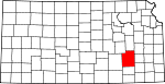
Hamilton County 075 Syracuse 1873 From unorganized area Alexander Hamilton, first U.S. Treasury Secretary and founding father HM 2,670 996 sq mi
(2,580 km2)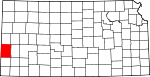
Harper County 077 Anthony 1867 From unorganized area Marion Harper, Union sergeant and Civil War hero HP 6,536 802 sq mi
(2,077 km2)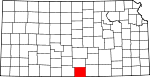
Harvey County 079 Newton 1872 Formed from McPherson, Sedgwick and Reno Counties James M. Harvey, fifth governor of Kansas HV 32,869 539 sq mi
(1,396 km2)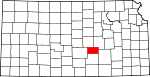
Haskell County 081 Sublette 1887 Formed from Finney and Ford Counties Dudley Chase Haskell, U.S. Representative from Kansas HS 4,307 577 sq mi
(1,494 km2)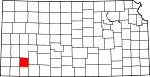
Hodgeman County 083 Jetmore 1867 From unorganized area (Formerly Hageman County) Amos Hodgman, Union captain and Civil War hero HG 2,085 860 sq mi
(2,227 km2)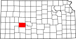
Jackson County 085 Holton 1855 One of the original 36 counties (Formerly Calhoun County) Andrew Jackson, seventh U.S. President JA 12,657 657 sq mi
(1,702 km2)
Jefferson County 087 Oskaloosa 1855 One of the original 36 counties Thomas Jefferson, third U.S. President and founding father JF 18,426 536 sq mi
(1,388 km2)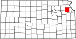
Jewell County 089 Mankato 1867 From unorganized area Lewis R. Jewell, Union colonel and Civil War hero JW 3,791 909 sq mi
(2,354 km2)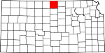
Johnson County 091 Olathe 1855 One of the original 36 counties Thomas Johnson, Methodist missionary who was one of the state's first settlers JO 506,562 477 sq mi
(1,235 km2)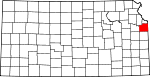
Kearny County 093 Lakin 1887 Formed from Finney and Hamilton Counties Philip Kearny, American general in the Mexican-American and Civil Wars KE 4,531 870 sq mi
(2,253 km2)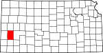
Kingman County 095 Kingman 1872 Harper and Reno Counties Samuel A. Kingman, Chief Justice of the Kansas Supreme Court KM 8,673 864 sq mi
(2,238 km2)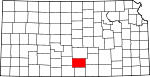
Kiowa County 097 Greensburg 1886 Formed from Comanche and Edwards Counties Kiowa Native Americans, who inhabited the area KW 3,278 722 sq mi
(1,870 km2)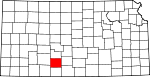
Labette County 099 Oswego 1867 Formed from Neosho County Pierre La Bette, French fur trapper who formed a peaceful relationship with area natives LB 22,835 649 sq mi
(1,681 km2)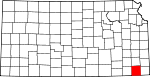
Lane County 101 Dighton 1873 From unorganized area James H. Lane, U.S. Senator from Kansas and Free-Stater during "Bleeding Kansas" LE 2,155 717 sq mi
(1,857 km2)
Leavenworth County 103 Leavenworth 1855 One of the original 36 counties Henry Leavenworth, general in the Indian Wars who established a fort in the area LV 68,691 463 sq mi
(1,199 km2)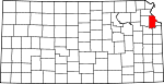
Lincoln County 105 Lincoln 1867 From unorganized area Abraham Lincoln, sixteenth U.S. President LC 3,578 719 sq mi
(1,862 km2)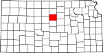
Linn County 107 Mound City 1855 One of the original 36 counties Lewis Fields Linn, U.S. Senator from Kentucky whose family was later involved in the settlement of Kansas LN 9,570 599 sq mi
(1,551 km2)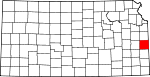
Logan County 109 Oakley 1888 Formed from Wallace County (formerly named St. John County) John Alexander Logan, prominent Union Civil War general and U.S. Senator from Illinois LG 3,046 1,073 sq mi
(2,779 km2)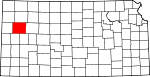
Lyon County 111 Emporia 1855 One of the original 36 counties (Formerly Breckenridge County) Nathaniel Lyon, first Union general to be killed in the Civil War LY 35,935 851 sq mi
(2,204 km2)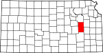
Marion County 115 Marion 1860 From unorganized area Francis Marion, American Revolutionary War hero MN 13,361 943 sq mi
(2,442 km2)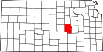
Marshall County 117 Marysville 1855 One of the original 36 counties Frank J. Marshall, state representative who became locally known for operating the first ferry over the Big Blue River MS 10,965 903 sq mi
(2,339 km2)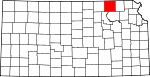
McPherson County 113 McPherson 1867 From unorganized area James Birdseye McPherson, prominent Union Civil War general MP 29,554 900 sq mi
(2,331 km2)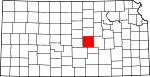
Meade County 119 Meade 1885 Formed from Finney, Ford and Seward Counties George Gordon Meade, Union Civil War general best known for his victory at the Battle of Gettysburg ME 4,631 978 sq mi
(2,533 km2)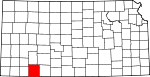
Miami County 121 Paola 1855 One of the original 36 counties (Formerly Lykins) Miami Native Americans, who lived in the area MI 28,351 577 sq mi
(1,494 km2)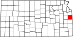
Mitchell County 123 Beloit 1867 From unorganized area William D. Mitchell, Union captain and Civil War hero MC 6,932 700 sq mi
(1,813 km2)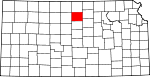
Montgomery County 125 Independence 1867 Formed from Wilson County Richard Montgomery, Revolutionary War hero MG 36,252 645 sq mi
(1,671 km2)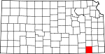
Morris County 127 Council Grove 1855 One of the original 36 counties (Formerly Wise County) Thomas Morris, U.S. Senator from Ohio and anti-slavery advocate MR 6,104 697 sq mi
(1,805 km2)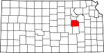
Morton County 129 Elkhart 1886 Formed from Seward County Oliver P. Morton, Governor of Indiana and prominent anti-slavery advocate MT 3,496 730 sq mi
(1,891 km2)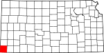
Nemaha County 131 Seneca 1855 One of the original 36 counties (Formerly Dorn County) Nemaha River, which passes through the county NM 10,717 719 sq mi
(1,862 km2)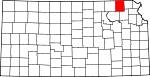
Neosho County 133 Erie 1855 One of the original 36 counties (Formerly Dorn County) Neosho River, which passes through the county NO 16,997 572 sq mi
(1,481 km2)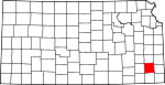
Ness County 135 Ness City 1867 From unorganized area Noah V. Ness, Corporal in 7th Regiment Kansas Volunteer Cavalry during Civil War[6] NS 3,454 1,075 sq mi
(2,784 km2)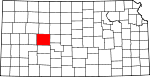
Norton County 137 Norton 1867 From unorganized area (Formerly Billings (1873-9) Orloff Norton, Union captain and Civil War hero NT 5,953 878 sq mi
(2,274 km2)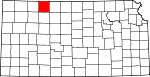
Osage County 139 Lyndon 1855 One of the original 36 counties (Formerly Weller County) Osage River, which flows through the county OS 16,712 704 sq mi
(1,823 km2)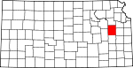
Osborne County 141 Osborne 1867 From unorganized area Vincent B. Osborne, Union soldier and Civil War hero OB 4,452 893 sq mi
(2,313 km2)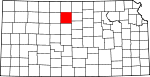
Ottawa County 143 Minneapolis 1860 From unorganized area Ottawa Native Americans, who lived in the area OT 6,163 721 sq mi
(1,867 km2)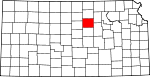
Pawnee County 145 Larned 1867 From unorganized area Pawnee Native Americans, who lived in the area PN 7,233 754 sq mi
(1,953 km2)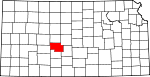
Phillips County 147 Phillipsburg 1867 From unorganized area William Phillips, state legislator who pushed for creation of the county, and later U.S. Representative PL 6,001 886 sq mi
(2,295 km2)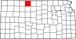
Pottawatomie County 149 Westmoreland 1857 Formed from Calhoun and Riley Pottawatomie Native Americans, who lived in the area PT 18,209 844 sq mi
(2,186 km2)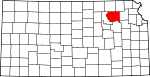
Pratt County 151 Pratt 1867 From unorganized area Caleb Pratt, Union lieutenant and Civil War hero PR 9,647 735 sq mi
(1,904 km2)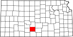
Rawlins County 153 Atwood 1873 From unorganized area John Aaron Rawlins, prominent Union Civil War general RA 2,966 1,070 sq mi
(2,771 km2)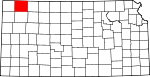
Reno County 155 Hutchinson 1867 From unorganized area Jesse L. Reno, prominent Union Civil War general RN 64,790 1,254 sq mi
(3,248 km2)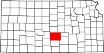
Republic County 157 Belleville 1868 Formed from Washington County Republican River, which flows through the county RP 5,835 716 sq mi
(1,854 km2)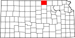
Rice County 159 Lyons 1867 From unorganized area Samuel A. Rice, prominent Union Civil War general RC 10,761 727 sq mi
(1,883 km2)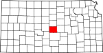
Riley County 161 Manhattan 1855 One of the original 36 counties Bennett C. Riley, Mexican-American War hero RL 62,843 610 sq mi
(1,580 km2)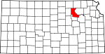
Rooks County 163 Stockton 1867 From unorganized area John C. Rooks, Private in 11th Regiment Kansas Volunteer Cavalry during Civil War[7] RO 5,685 888 sq mi
(2,300 km2)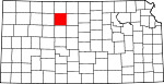
Rush County 165 La Crosse 1867 From unorganized area Alexander Rush, Union captain and Civil War hero RH 3,551 718 sq mi
(1,860 km2)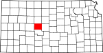
Russell County 167 Russell 1867 From unorganized area Alva P. Russell, Union captain and Civil War hero RS 7,370 885 sq mi
(2,292 km2)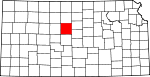
Saline County 169 Salina 1860 From unorganized area Saline River, which flows through the county SA 53,597 720 sq mi
(1,865 km2)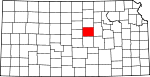
Scott County 171 Scott City 1873 From unorganized area Winfield Scott, Mexican-American War hero and unsuccessful presidential candidate SC 5,120 718 sq mi
(1,860 km2)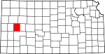
Sedgwick County 173 Wichita 1867 Formed from Butler County John Sedgwick, highest ranking Union general killed in the Civil War SG 452,869 1,000 sq mi
(2,590 km2)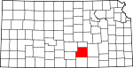
Seward County 175 Liberal 1873 From unorganized area William Henry Seward, U.S. Secretary of State SW 22,510 640 sq mi
(1,658 km2)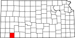
Shawnee County 177 Topeka 1855 One of the original 36 counties Shawnee Native Americans, who lived in the area SN 169,871 550 sq mi
(1,424 km2)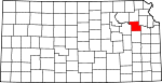
Sheridan County 179 Hoxie 1873 From unorganized area Philip Henry Sheridan, prominent Union Civil War general SD 2,813 896 sq mi
(2,321 km2)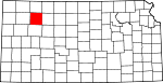
Sherman County 181 Goodland 1873 From unorganized area William Tecumseh Sherman, prominent Civil War general known for his scorched earth tactics SH 6,760 1,056 sq mi
(2,735 km2)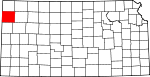
Smith County 183 Smith Center 1867 From unorganized area J. Nelson Smith, Union major and Civil War hero SM 4,536 896 sq mi
(2,321 km2)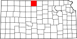
Stafford County 185 Saint John 1867 From unorganized area Lewis Stafford, Union captain and Civil War hero SF 4,789 792 sq mi
(2,051 km2)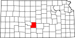
Stanton County 187 Johnson City 1887 Formed from Hamilton County Edwin McMasters Stanton, U.S. Secretary of War during the Civil War ST 2,406 680 sq mi
(1,761 km2)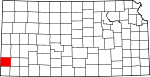
Stevens County 189 Hugoton 1886 Formed from Seward County Thaddeus Stevens, U.S. Senator from Pennsylvania who was a leader of Reconstruction politics SV 5,463 728 sq mi
(1,886 km2)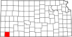
Sumner County 191 Wellington 1867 Formed from Butler County Charles Sumner, U.S. Senator from Massachusetts who was a leader of Reconstruction politics SU 25,946 1,182 sq mi
(3,061 km2)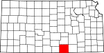
Thomas County 193 Colby 1873 From unorganized area George Henry Thomas, prominent Union Civil War general TH 8,180 1,075 sq mi
(2,784 km2)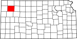
Trego County 195 WaKeeney 1867 From unorganized area Edgar P. Trego, Union captain and Civil War hero TR 3,319 888 sq mi
(2,300 km2)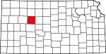
Wabaunsee County 197 Alma 1855 One of the original 36 counties (Formerly Richardson County) Chief Wabaunsee, Potawatomi leader WB 6,885 798 sq mi
(2,067 km2)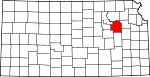
Wallace County 199 Sharon Springs 1868 From unorganized area W.H.L. Wallace, prominent Union Civil War genearl WA 1,749 914 sq mi
(2,367 km2)
Washington County 201 Washington 1857 From unorganized area George Washington, first U.S. President and founding father WS 6,483 898 sq mi
(2,326 km2)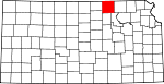
Wichita County 203 Leoti 1873 From unorganized area Wichita Native Americans, who lived in the area WH 2,531 719 sq mi
(1,862 km2)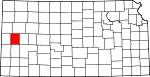
Wilson County 205 Fredonia 1855 One of the original 36 counties Hiero T. Wilson, Union colonel and Civil War hero WL 10,332 574 sq mi
(1,487 km2)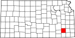
Woodson County 207 Yates Center 1855 One of the original 36 counties Daniel Woodson, five time acting governor of Kansas Territory WO 3,788 501 sq mi
(1,298 km2)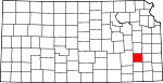
Wyandotte County 209 Kansas City 1859 Formed from Leavenworth and Johnson Counties Wyandotte Native Americans, who lived in the area WY 157,882 151 sq mi
(391 km2)
Former counties of Kansas
Sortable table County Dates Notes Source Washington 1855–1857 One of 36 Original Counties. [8] Seward 1855-67 One of the Original 36 Counties. Formerly part of Godfroy. Dissolved into Greenwood and Howard Counties. [9] Hunter 1855-64 One of the Original 36 Counties. Dissolved into Butler County. [10] Irving 1860-4 Formed from Hunter County. Dissolved into Butler County. [11] Otoe 1860-4 Formed from Unorganized Area and dissolved into Butler County. [12] Shirley 1860-5 Formed from Unorganized Area and dissolved into Washington County. [13] Peketon 1860-5 Formed from Unorganized Area and dissolved back into Unorganized Area. [14] Madison 1855-61 One of the Original 36 Counties. Dissolved into Breckenridge and Greenwood. [15] Howard 1867-75 Formed from Seward and Butler Counties. Dissolved into Chautauqua and Elk Counties. [16] Arapahoe 1873-83 Formed from Unorganized Area. Dissolved into Finney County. [17] Buffalo 1873-81 Formed from Unorganized Area. Dissolved into Gray County. [18] Kansas 1873-83 Formed from Unorganized Area. Dissolved into Seward County. [19] Sequoyah 1873-83 Formed from Unorganized Area. Dissolved into Finney County. [20] Garfield 1887-93 Formed from Finney and Hodgeman Counties and merged into Finney County. [21] Billings 1873–1874 Created from Norton County and returned to Norton County. [22] See also
- Kansas counties ranked by per capita income
- Kansas license plate county codes
- Kansas census statistical areas
References
- ^ "EPA County FIPS Code Listing". EPA.gov. http://www.epa.gov/enviro/html/codes/ks.html. Retrieved 2008-04-30.
- ^ a b c d National Association of Counties. "NACo - Find a county". http://www.naco.org/Template.cfm?Section=Find_a_County&Template=/cffiles/counties/state.cfm&state.cfm&statecode=KS. Retrieved 2008-04-30.
- ^ Kansas State Historical Society (2009-12-17). "Kansas Counties". Kansas County Factsheets. Kansas State Historical Society. http://www.kshs.org/genealogists/places/counties.htm. Retrieved 21 March 2010. Individual county pages are sources used.
- ^ Kansas Place-Names,John Rydjord, University of Oklahoma Press, 1972, p. 400 ISBN 0-8061-0994-7
- ^ Kansas Place-Names,John Rydjord, University of Oklahoma Press, 1972, p. 403 ISBN 0-8061-0994-7
- ^ Kansas Place-Names,John Rydjord, University of Oklahoma Press, 1972, p. 407 ISBN 0-8061-0994-7
- ^ Kansas Place-Names,John Rydjord, University of Oklahoma Press, 1972, p. 400 ISBN 0-8061-0994-7
- ^ Kansas State Historical Society. "Washington County, Kansas (old) (defunct)". Kansas County Factsheets. Kansas State Historical Society. http://www.kshs.org/geog/geog_counties/view/county:WG. Retrieved 27 November 2010.
- ^ Kansas State Historical Society. "Seward County, Kansas (defunct)". Kansas County Factsheets. Kansas State Historical Society. http://www.kshs.org/geog/geog_counties/view/county:SE. Retrieved 27 November 2010.
- ^ Kansas State Historical Society. "Hunter County, Kansas (defunct)". Kansas County Factsheets. Kansas State Historical Society. http://www.kshs.org/geog/geog_counties/view/county:HU. Retrieved 27 November 2010.
- ^ Kansas State Historical Society. "Irving County, Kansas (defunct)". Kansas County Factsheets. Kansas State Historical Society. http://www.kshs.org/geog/geog_counties/view/county:IR. Retrieved 27 November 2010.
- ^ Kansas State Historical Society. "Otoe County, Kansas (defunct)". Kansas County Factsheets. Kansas State Historical Society. http://www.kshs.org/geog/geog_counties/view/county:OE. Retrieved 27 November 2010.
- ^ Kansas State Historical Society. "Shirley County, Kansas (defunct)". Kansas County Factsheets. Kansas State Historical Society. http://www.kshs.org/geog/geog_counties/view/county:SL. Retrieved 27 November 2010.
- ^ Kansas State Historical Society. "Peketon County, Kansas (defunct)". Kansas County Factsheets. Kansas State Historical Society. http://www.kshs.org/geog/geog_counties/view/county:PK. Retrieved 27 November 2010.
- ^ Kansas State Historical Society. "Madison County, Kansas (defunct)". Kansas County Factsheets. Kansas State Historical Society. http://www.kshs.org/geog/geog_counties/view/county:MD. Retrieved 27 November 2010.
- ^ Kansas State Historical Society. "Howard County, Kansas (defunct)". Kansas County Factsheets. Kansas State Historical Society. http://www.kshs.org/geog/geog_counties/view/county:HO. Retrieved 27 November 2010.
- ^ Kansas State Historical Society. "Arapahoe County, Kansas (2nd) (defunct)". Kansas County Factsheets. Kansas State Historical Society. http://www.kshs.org/geog/geog_counties/view/county:AA. Retrieved 27 November 2010.
- ^ Kansas State Historical Society. "Buffalo County, Kansas (defunct)". Kansas County Factsheets. Kansas State Historical Society. http://www.kshs.org/geog/geog_counties/view/county:BF. Retrieved 27 November 2010.
- ^ Kansas State Historical Society. "Kansas County, Kansas (defunct)". Kansas County Factsheets. Kansas State Historical Society. http://www.kshs.org/geog/geog_counties/view/county:KS. Retrieved 27 November 2010.
- ^ Kansas State Historical Society. "Sequoyah County, Kansas (defunct)". Kansas County Factsheets. Kansas State Historical Society. http://www.kshs.org/geog/geog_counties/view/county:SQ. Retrieved 27 November 2010.
- ^ Kansas State Historical Society. "Garfield County, Kansas (defunct)". Kansas County Factsheets. Kansas State Historical Society. http://www.kshs.org/geog/geog_counties/view/county:GF. Retrieved 27 November 2010.
- ^ Kansas State Historical Society. "Billings County, Kansas (defunct)". Kansas County Factsheets. Kansas State Historical Society. http://www.kshs.org/geog/geog_counties/view/county:BI. Retrieved 27 November 2010.
External links
- The Establishment of Counties in Kansas—Maps and text transcribed from Transactions of the Kansas State Historical Society, 1903-1904.
 State of Kansas
Topics Society Regions Largest cities Counties - Allen
- Anderson
- Atchison
- Barber
- Barton
- Bourbon
- Brown
- Butler
- Chase
- Chautauqua
- Cherokee
- Cheyenne
- Clark
- Clay
- Cloud
- Coffey
- Comanche
- Cowley
- Crawford
- Decatur
- Dickinson
- Doniphan
- Douglas
- Edwards
- Elk
- Ellis
- Ellsworth
- Finney
- Ford
- Franklin
- Geary
- Gove
- Graham
- Grant
- Gray
- Greeley
- Greenwood
- Hamilton
- Harper
- Harvey
- Haskell
- Hodgeman
- Jackson
- Jefferson
- Jewell
- Johnson
- Kearny
- Kingman
- Kiowa
- Labette
- Lane
- Leavenworth
- Lincoln
- Linn
- Logan
- Lyon
- Marion
- Marshall
- McPherson
- Meade
- Miami
- Mitchell
- Montgomery
- Morris
- Morton
- Nemaha
- Neosho
- Ness
- Norton
- Osage
- Osborne
- Ottawa
- Pawnee
- Phillips
- Pottawatomie
- Pratt
- Rawlins
- Reno
- Republic
- Rice
- Riley
- Rooks
- Rush
- Russell
- Saline
- Scott
- Sedgwick
- Seward
- Shawnee
- Sheridan
- Sherman
- Smith
- Stafford
- Stanton
- Stevens
- Sumner
- Thomas
- Trego
- Wabaunsee
- Wallace
- Washington
- Wichita
- Wilson
- Woodson
- Wyandotte
Categories:- Lists of U.S. counties by state
- Kansas counties
- Kansas-related lists


Wikimedia Foundation. 2010.