- Clay Center, Kansas
-
Clay Center, Kansas — City — Location of Clay Center, Kansas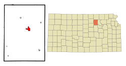
Coordinates: 39°22′48″N 97°7′23″W / 39.38°N 97.12306°WCoordinates: 39°22′48″N 97°7′23″W / 39.38°N 97.12306°W Country United States State Kansas County Clay Government - Mayor Sharon Brown - City Clerk Calvin Wohler Area - Total 2.6 sq mi (6.7 km2) - Land 2.6 sq mi (6.7 km2) - Water 0.0 sq mi (0.0 km2) Elevation 1,201 ft (366 m) Population (2010)[1] - Total 4,334 - Density 1,666.9/sq mi (643.6/km2) Time zone Central (CST) (UTC-6) - Summer (DST) CDT (UTC-5) ZIP code 67432 Area code(s) 785 FIPS code 20-13625[2] GNIS feature ID 0476034[3] Website City website Clay Center is a city in and the county seat of Clay County, Kansas, United States.[4] As of the 2010 census, the city population was 4,334.[1]
Contents
Geography
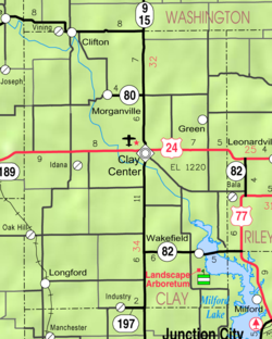
Clay Center is located at 39°22′48″N 97°7′23″W / 39.38°N 97.12306°W (39.379920, -97.123168)[5]. According to the United States Census Bureau, the city has a total area of 2.6 square miles (6.7 km2), all of it land.
Area events
- Piotique Festival, annual fall festival.
Demographics
Historical populations Census Pop. %± 1990 4,613 — 2000 4,564 −1.1% 2010 4,334 −5.0% U.S. Decennial Census As of the census[2] of 2000, there were 4,564 people, 1,979 households, and 1,258 families residing in the city. The population density was 1,762.4 people per square mile (680.4/km²). There were 2,191 housing units at an average density of 846.0 per square mile (326.6/km²). The racial makeup of the city was 97.98% White, 0.64% African American, 0.33% Native American, 0.20% Asian, 0.07% from other races, and 0.79% from two or more races. Hispanic or Latino of any race were 0.53% of the population.
There were 1,979 households out of which 27.0% had children under the age of 18 living with them, 52.6% were married couples living together, 7.2% had a female householder with no husband present, and 36.4% were non-families. 33.4% of all households were made up of individuals and 19.7% had someone living alone who was 65 years of age or older. The average household size was 2.24 and the average family size was 2.83.
In the city the population was spread out with 23.0% under the age of 18, 7.3% from 18 to 24, 22.0% from 25 to 44, 22.5% from 45 to 64, and 25.1% who were 65 years of age or older. The median age was 43 years. For every 100 females there were 94.0 males. For every 100 females age 18 and over, there were 88.7 males.
The median income for a household in the city was $31,531, and the median income for a family was $45,567. Males had a median income of $29,526 versus $16,149 for females. The per capita income for the city was $19,128. About 5.9% of families and 9.8% of the population were below the poverty line, including 12.5% of those under age 18 and 10.0% of those age 65 or over.
Government
The Clay Center government consists of a mayor and eight council members. The council meets the 1st and 3rd Tuesday of each month at 7:30PM.
- City Hall, 427 Court St.
Notable people
- Herb Bradley, professional baseball player
- Warren Henry Cole, surgeon who pioneered X-ray use in medicine
- George Docking, former governor of Kansas
- Steve Doocy, Host for Fox News "Fox and Friends"
- Tenney Frank, noted scholar and historian
- Nicole Ohlde, professional basketball player
- William D. Vincent, United States Representative
References
- ^ a b "2010 City Population and Housing Occupancy Status". U.S. Census Bureau. http://factfinder2.census.gov/faces/tableservices/jsf/pages/productview.xhtml?pid=DEC_10_PL_GCTPL2.ST13&prodType=table. Retrieved March 27, 2011.
- ^ a b "American FactFinder". United States Census Bureau. http://factfinder.census.gov. Retrieved 2008-01-31.
- ^ "US Board on Geographic Names". United States Geological Survey. 2007-10-25. http://geonames.usgs.gov. Retrieved 2008-01-31.
- ^ "Find a County". National Association of Counties. http://www.naco.org/Counties/Pages/FindACounty.aspx. Retrieved 2011-06-07.
- ^ "US Gazetteer files: 2010, 2000, and 1990". United States Census Bureau. 2011-02-12. http://www.census.gov/geo/www/gazetteer/gazette.html. Retrieved 2011-04-23.
Further reading
- History of the State of Kansas; William G. Cutler; A.T. Andreas Publisher; 1883. (Online HTML eBook)
- Kansas : A Cyclopedia of State History, Embracing Events, Institutions, Industries, Counties, Cities, Towns, Prominent Persons, Etc; 3 Volumes; Frank W. Blackmar; Standard Publishing Co; 944 / 955 / 824 pages; 1912. (Volume1 - Download 54MB PDF eBook),(Volume2 - Download 53MB PDF eBook), (Volume3 - Download 33MB PDF eBook)
External links
- City of Clay Center
- Clay Center - Directory of Public Officials
- Clay Center - Chamber of Commerce
- Clay Center - Info
- Schools
- USD 379, local school district
- Newspapers
- Maps
- Clay Center City Map, KDOT
- Clay County Map, KDOT
Municipalities and communities of Clay County, Kansas County seat: Clay CenterCities 
Townships Athelstane | Blaine | Bloom | Chapman | Clay Center | Exeter | Five Creeks | Garfield | Gill | Goshen | Grant | Hayes | Highland | Mulberry | Oakland | Republican | Sherman | Union
Unincorporated
communitiesIdana | Industry‡ | Ladysmith
Footnotes ‡This populated place also has portions in an adjacent county or counties
Categories:- Cities in Kansas
- Populated places in Clay County, Kansas
- County seats in Kansas


Wikimedia Foundation. 2010.