- Ottawa County, Kansas
-
Ottawa County, Kansas 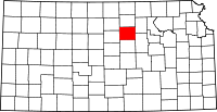
Location in the state of Kansas
Kansas's location in the U.S.Founded February 27, 1860 Seat Minneapolis Area
- Total
- Land
- Water
721.90 sq mi (1,870 km²)
721.11 sq mi (1,868 km²)
0.79 sq mi (2 km²), 0.11%Population
- (2010)
- Density
6,091
8.5/sq mi (3.3/km²)Time zone Central: UTC-6/-5 Website OttawaCounty.org Ottawa County (standard abbreviation: OT) is a county located in the U.S. state of Kansas. As of the 2010 census, the county population was 6,091.[1] The largest city and county seat is Minneapolis. Ottawa County is part of the Salina Micropolitan Statistical Area.
The county should not be confused with the city of Ottawa, which is located in Franklin County.
Contents
Law and government
Following amendment to the Kansas Constitution in 1986, Ottawa County remained a prohibition, or "dry", county until 2006, when voters approved the sale of alcoholic liquor by the individual drink with a 30% food sales requirement.[2]
Geography
According to the 2000 census, the county has a total area of 721.90 square miles (1,869.7 km2), of which 721.11 square miles (1,867.7 km2) (or 99.89%) is land and 0.79 square miles (2.0 km2) (or 0.11%) is water.[3]
Geographic features
The Solomon River is the longest river in the county, entering from Cloud County to the northwest and exiting to Saline County to the southeast. The Saline River traverses the southwestern portion of the county, going from Lincoln County to Saline County.
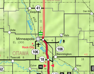
The largest lake is Ottawa State Fishing Lake, a 111-acre (0.45 km2) reservoir to the east of Minneapolis.[4] It is managed by the Kansas Department of Wildlife and Parks.
Adjacent counties
- Cloud County (north)
- Clay County (northeast)
- Dickinson County (southeast)
- Saline County (south)
- Lincoln County (west)
- Mitchell County (northwest)
Demographics
Historical populations Census Pop. %± 1900 11,182 — 1910 11,811 5.6% 1920 10,714 −9.3% 1930 9,819 −8.4% 1940 9,224 −6.1% 1950 7,265 −21.2% 1960 6,779 −6.7% 1970 6,183 −8.8% 1980 5,971 −3.4% 1990 5,634 −5.6% 2000 6,163 9.4% 2010 6,091 −1.2% U.S. Decennial Census 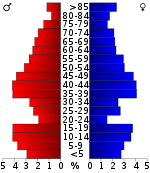 Age pyramid
As of the census[5] of 2000, there were 6,163 people, 2,430 households, and 1,718 families residing in the county. The population density was 8 people per square mile (3/km²). There were 2,755 housing units at an average density of 4 per square mile (1/km²). The racial makeup of the county was 97.53% White, 0.54% Black or African American, 0.37% Native American, 0.13% Asian, 0.02% Pacific Islander, 0.32% from other races, and 1.09% from two or more races. 1.30% of the population were Hispanic or Latino of any race.
There were 2,430 households out of which 31.60% had children under the age of 18 living with them, 61.40% were married couples living together, 6.30% had a female householder with no husband present, and 29.30% were non-families. 25.70% of all households were made up of individuals and 13.40% had someone living alone who was 65 years of age or older. The average household size was 2.46 and the average family size was 2.96.
In the county the population was spread out with 25.70% under the age of 18, 5.80% from 18 to 24, 26.70% from 25 to 44, 24.20% from 45 to 64, and 17.60% who were 65 years of age or older. The median age was 40 years. For every 100 females there were 99.90 males. For every 100 females age 18 and over, there were 95.90 males.
The median income for a household in the county was $38,009, and the median income for a family was $46,033. Males had a median income of $30,761 versus $21,380 for females. The per capita income for the county was $17,663. About 5.10% of families and 8.60% of the population were below the poverty line, including 8.80% of those under age 18 and 11.70% of those age 65 or over.
Cities and towns
Incorporated cities
Name and population (2004 estimate):
- Minneapolis, 2,037 (county seat)
- Bennington, 618
- Delphos, 456
- Tescott, 336
- Culver, 167
Townships
Ottawa County is divided into twenty townships. The city of Minneapolis is considered governmentally independent and is excluded from the census figures for the townships. In the following table, the population center is the largest city (or cities) included in that township's population total, if it is of a significant size.
Sources: 2000 U.S. Gazetteer from the U.S. Census Bureau. Township FIPS Population
centerPopulation Population
density
/km² (/sq mi)Land area
km² (sq mi)Water area
km² (sq mi)Water % Geographic coordinates Bennington 06100 1,116 10 (27) 109 (42) 0 (0) 0.11% 39°0′31″N 97°36′20″W / 39.00861°N 97.60556°W Blaine 07150 111 1 (3) 94 (36) 0 (0) 0.07% 39°10′7″N 97°39′50″W / 39.16861°N 97.66389°W Buckeye 08975 101 1 (3) 78 (30) 0 (0) 0.13% 39°0′4″N 97°31′20″W / 39.00111°N 97.52222°W Center 11975 72 1 (2) 92 (36) 0 (0) 0.17% 39°6′53″N 97°44′39″W / 39.11472°N 97.74417°W Chapman 12575 67 1 (2) 93 (36) 0 (0) 0 % 39°16′47″N 97°24′53″W / 39.27972°N 97.41472°W Concord 15175 209 2 (6) 90 (35) 0 (0) 0.08% 39°5′9″N 97°39′37″W / 39.08583°N 97.66028°W Culver 16725 318 3 (9) 94 (36) 0 (0) 0.08% 38°59′40″N 97°46′14″W / 38.99444°N 97.77056°W Durham 19075 25 0 (1) 93 (36) 0 (0) 0.02% 39°9′57″N 97°24′54″W / 39.16583°N 97.415°W Fountain 24075 190 2 (5) 94 (36) 0 (0) 0.02% 39°10′6″N 97°53′1″W / 39.16833°N 97.88361°W Garfield 25725 95 1 (3) 94 (36) 0 (0) 0.11% 39°10′37″N 97°45′5″W / 39.17694°N 97.75139°W Grant 27900 93 1 (3) 94 (36) 0 (0) 0.03% 39°9′53″N 97°33′14″W / 39.16472°N 97.55389°W Henry 31325 22 0 (1) 93 (36) 0 (0) 0.14% 39°6′18″N 97°53′6″W / 39.105°N 97.885°W Lincoln 40950 143 2 (4) 93 (36) 0 (0) 0.10% 38°59′31″N 97°26′13″W / 38.99194°N 97.43694°W Logan 42050 82 1 (2) 93 (36) 0 (0) 0.10% 39°15′4″N 97°38′29″W / 39.25111°N 97.64139°W Morton 48500 498 5 (14) 93 (36) 0 (0) 0.14% 39°0′32″N 97°52′23″W / 39.00889°N 97.87306°W Ottawa 53600 49 1 (1) 93 (36) 0 (0) 0.03% 39°4′1″N 97°26′11″W / 39.06694°N 97.43639°W Richland 59500 218 2 (6) 92 (36) 0 (0) 0.51% 39°5′45″N 97°32′53″W / 39.09583°N 97.54806°W Sheridan 64725 589 6 (16) 94 (36) 0 (0) 0.06% 39°16′3″N 97°46′2″W / 39.2675°N 97.76722°W Sherman 65025 67 1 (2) 94 (36) 0 (0) 0 % 39°16′1″N 97°32′27″W / 39.26694°N 97.54083°W Stanton 67950 52 1 (1) 95 (37) 0 (0) 0.27% 39°15′21″N 97°52′45″W / 39.25583°N 97.87917°W Education
Unified school districts
See also
- Dry counties
Information on this and other counties in Kansas
- List of counties in Kansas
- National Register of Historic Places listings in Kansas
- Kansas locations by per capita income
Other information for Kansas
- List of cities in Kansas
- List of unified school districts in Kansas
- List of colleges and universities in Kansas
References
- ^ "2010 County Population and Housing Occupancy Status". U.S. Census Bureau. http://factfinder2.census.gov/faces/tableservices/jsf/pages/productview.xhtml?pid=DEC_10_PL_GCTPL2.ST05&prodType=table. Retrieved April 5, 2011.
- ^ "Map of Wet and Dry Counties". Alcoholic Beverage Control, Kansas Department of Revenue. November 2006. http://www.ksrevenue.org/abcwetdrymap.htm. Retrieved 2007-12-26.
- ^ "Census 2000 U.S. Gazetteer Files: Counties". United States Census. http://www.census.gov/tiger/tms/gazetteer/county2k.txt. Retrieved 2011-02-13.
- ^ "Ottawa State Fishing Lake". http://www.kdwp.state.ks.us/news/fishing/where_to_fish_in_kansas/fishing_locations_public_waters/region_1/ottawa_state_fishing_lake. Retrieved 2008-06-11.
- ^ "American FactFinder". United States Census Bureau. http://factfinder.census.gov. Retrieved 2008-01-31.
Further reading
- History of the State of Kansas; William G. Cutler; A.T. Andreas Publisher; 1883. (Online HTML eBook)
- Kansas : A Cyclopedia of State History, Embracing Events, Institutions, Industries, Counties, Cities, Towns, Prominent Persons, Etc; 3 Volumes; Frank W. Blackmar; Standard Publishing Co; 944 / 955 / 824 pages; 1912. (Volume1 - Download 54MB PDF eBook),(Volume2 - Download 53MB PDF eBook), (Volume3 - Download 33MB PDF eBook)
External links
- County
- Ottawa County - Official Website
- Ottawa County - Directory of Public Officials
- Ottawa County - Information, Skyways
- Maps
- Ottawa County Map, KDOT
- Kansas Highway Map, KDOT
- Kansas Railroad Map, KDOT
- Kansas School District Boundary Map, KSDE

Mitchell County Cloud County Clay County 
 Ottawa County, Kansas

Lincoln County Saline County Dickinson County Municipalities and communities of Ottawa County, Kansas Cities Bennington | Culver | Delphos | Minneapolis | Tescott

Unincorporated
communitySumnerville
Categories:- Kansas counties
- Ottawa County, Kansas
- 1860 establishments
- Salina micropolitan area


Wikimedia Foundation. 2010.