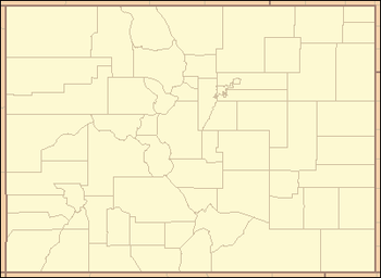
- List of counties in Colorado
-
 Main article: Colorado counties
The following is a list of the 64 counties of the U.S. state of Colorado. Two of these counties, the City and County of Denver and the City and County of Broomfield, have consolidated city and county governments.
Colorado's postal abbreviation is CO and its FIPS state code is 08.
Contents
Table
County FIPS code
[1][2]County seat
[3][4]Established
[5]Formed from
[5]Etymolgy
[5]Population
[6]Area
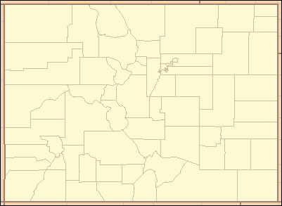
[4]Map Adams County 001 Brighton 1902-11-15 Split from Arapahoe County. Named in honor of Alva Adams, the 5th, 10th, and 14th Governor of the State of Colorado. 441,603 1,182.29 sq mi
(3,062 km2)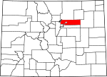
Alamosa County 003 Alamosa 1913-03-08 Split from Costilla County and Conejos County counties. Named for the cottonwood trees which grow along the Rio Grande and its tributaries. Alamosa is a Spanish word for a cottonwood grove. 15,445 723.21 sq mi
(1,873 km2)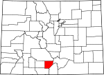
Arapahoe County 005 Littleton 1861-11-01 Created as one of the 17 original counties of the Territory of Colorado. Renamed South Arapahoe County for the five months from November 15, 1902 to April 11, 1903. Named for predecessor Arapahoe County, Kansas Territory, which in turn was named for the Arapaho Nation of Native Americans. 572,003 804.41 sq mi
(2,083 km2)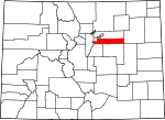
Archuleta County 007 Pagosa Springs 1885-04-14 Split from Conejos County. Named in honor of Colorado State Senator Antonio D. Archuleta. 12,084 1,354.53 sq mi
(3,508 km2)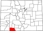
Baca County 009 Springfield 1889-04-16 Split from Las Animas County. Named in honor of pioneer and Colorado territorial legislator Felipe Baca. 3,788 2,558.48 sq mi
(6,626 km2)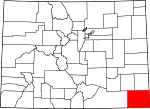
Bent County 011 Las Animas 1870-02-11 Split from Huerfano County and former Cheyenne and Arapaho tribal land. Named in honor of frontier trader William Bent. 6,499 1,541.07 sq mi
(3,991 km2)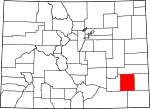
Boulder County 013 Boulder 1861-11-01 Created as one of the 17 original counties of the Territory of Colorado. Named for the abundance of granite boulders along Boulder Creek. 294,567 740.48 sq mi
(1,918 km2)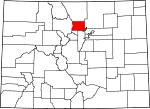
Broomfield County 014 Broomfield 2001-11-15 Split from Boulder, Adams, Jefferson, and Weld counties and reorganized as a consolidated city and county. Named for the broom corn that was formerly grown in the area. 55,889 33.57 sq mi
(87 km2)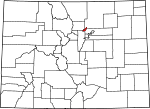
Chaffee County 015 Salida 1879-02-10 Split from Carbonate County. Named in honor of Jerome Bunty Chaffee, one of Colorado's first two U.S. Senators from 1876 to 1879. 17,809 1,014.12 sq mi
(2,627 km2)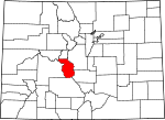
Cheyenne County 017 Cheyenne Wells 1889-03-25 Split from Elbert and Bent counties. Named for the Cheyenne Nation of Native Americans. 1,836 1,781.90 sq mi
(4,615 km2)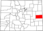
Clear Creek County 019 Georgetown 1861-11-01 Created as one of the 17 original counties of the Territory of Colorado. Named for Clear Creek which originates in the county. 9,088 396.53 sq mi
(1,027 km2)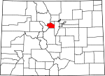
Conejos County 021 Conejos 1861-11-01 Guadalupe County, one of the 17 original counties of the Territory of Colorado, was renamed Conejos County after six days on November 7, 1861. Named for the cottontail rabbits in the area. Conejos is a Spanish word for rabbits. 8,256 1,290.22 sq mi
(3,342 km2)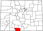
Costilla County 023 San Luis 1861-11-01 Created as one of the 17 original counties of the Territory of Colorado. Named for the Costilla River. Costilla is a Spanish word meaning either little rib or furring timber. 3,524 1,229.38 sq mi
(3,184 km2)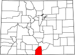
Crowley County 025 Ordway 1911-05-29 Split from Otero County. Named in honor of Colorado State Senator John H. Crowley. 5,823 800.27 sq mi
(2,073 km2)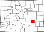
Custer County 027 Westcliffe 1877-03-09 Split from Fremont County. Named in honor of George Armstrong Custer, the U.S. Army colonel defeated and killed at the Battle of Little Bighorn. 4,255 739.24 sq mi
(1,915 km2)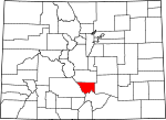
Delta County 029 Delta 1883-02-11 Split from Gunnison County. Named for the town of Delta located at the delta of the Uncompahgre River. 30,952 1,149.44 sq mi
(2,977 km2)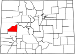
Denver County 031 Denver 1902-11-15 The original Arapahoe County Seat was split from Arapahoe County and reorganized as a consolidated city and county. Named in honor of James W. Denver, Governor of the Territory of Kansas from 1857 to 1859. 600,158 155.66 sq mi
(403 km2)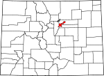
Dolores County 033 Dove Creek 1881-03-04 Split from Ouray County. Named for the Dolores River, which was originally named el Rio de Nuestra Senora de los Dolores, which is Spanish for the River of our Lady of Sorrows. 2,064 1,076.93 sq mi
(2,789 km2)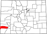
Douglas County 035 Castle Rock 1861-11-01 Created as one of the 17 original counties of the Territory of Colorado. Named in honor of Stephen Arnold Douglas, U.S. Senator from Illinois from 1847 to 1861. 285,465 842.30 sq mi
(2,182 km2)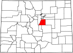
Eagle County 037 Eagle 1883-02-11 Split from Summit County. Named for the Eagle River which originates in the county. 52,197 1,700.76 sq mi
(4,405 km2)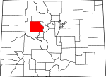
El Paso County 041 Colorado Springs 1861-11-01 Created as one of the 17 original counties of the Territory of Colorado. Named for Ute Pass in the county. El paso is a Spanish expression for the pass. 622,263 2,128.60 sq mi
(5,513 km2)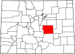
Elbert County 039 Kiowa 1874-02-02 Split from Douglas County. Named in honor of Samuel Hitt Elbert, the sixth Governor of the Territory of Colorado. 23,086 1,849.08 sq mi
(4,789 km2)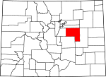
Fremont County 043 Cañon City 1861-11-01 Created as one of the 17 original counties of the Territory of Colorado. Named in honor of John Charles Frémont, the explorer, U.S. Army general, and U.S. Senator from California. 46,824 1,533.09 sq mi
(3,971 km2)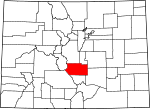
Garfield County 045 Glenwood Springs 1883-02-10 Split from Summit County. Named in honor of James Abram Garfield, the twentieth President of the United States. 56,389 2,958.23 sq mi
(7,662 km2)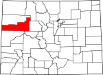
Gilpin County 047 Central City 1861-11-01 Created as one of the 17 original counties of the Territory of Colorado. Named in honor of William Gilpin, the first Governor of the Territory of Colorado. 5,441 150.15 sq mi
(389 km2)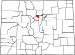
Grand County 049 Hot Sulphur Springs 1874-02-02 Split from Summit County. Named for the Grand River which originates in the county. The Grand River was renamed the Colorado River in 1921, but the county retains the original name. 14,843 1,868.53 sq mi
(4,839 km2)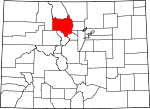
Gunnison County 051 Gunnison 1877-03-09 Split from Lake County. Named in honor of John Williams Gunnison, the U.S. Army captain who explored the region. 15,324 3,259.22 sq mi
(8,441 km2)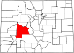
Hinsdale County 053 Lake City 1874-02-10 Split from Lake, Conejos, and Costilla counties. Named in honor of George Aaron Hinsdale, a Lieutenant Governor of the Territory of Colorado. 843 1,123.35 sq mi
(2,909 km2)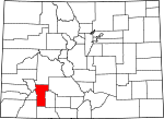
Huerfano County 055 Walsenburg 1861-11-01 Created as one of the 17 original counties of the Territory of Colorado. Named for Huerfano Butte, a solitary volcanic plug. Huerfano is a Spanish word meaning orphan. 6,711 1,592.37 sq mi
(4,124 km2)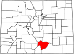
Jackson County 057 Walden 1909-05-05 Split from Larimer County. Named in honor of Andrew Jackson, the seventh President of the United States. 1,394 1,619.75 sq mi
(4,195 km2)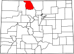
Jefferson County 059 Golden 1861-11-01 Created as one of the 17 original counties of the Territory of Colorado. Named for its extralegal predecessor county, Jefferson County, Jefferson Territory, which in turn was named in honor of Thomas Jefferson, the author of the Declaration of Independence and the third President of the United States. 534,543 772.85 sq mi
(2,002 km2)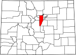
Kiowa County 061 Eads 1889-04-11 Split from Bent County. Named for the Kiowa Nation of Native Americans. 1,398 1,785.90 sq mi
(4,625 km2)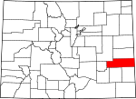
Kit Carson County 063 Burlington 1889-04-11 Split from Elbert County. Named in honor of Christopher Houston "Kit" Carson, the famous frontier scout and soldier. 8,270 2,162.43 sq mi
(5,601 km2)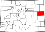
La Plata County 067 Durango 1874-02-10 Split from Lake and Conejos counties. Named for the many silver deposits in the area. La plata is a Spanish expression for the silver. 51,334 1,700.44 sq mi
(4,404 km2)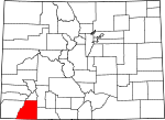
Lake County 065 Leadville 1861-11-01 Created as one of the 17 original counties of the Territory of Colorado. Renamed Carbonate County for the two days from February 8–10, 1879. Named for the Twin Lakes in the county. 7,310 383.55 sq mi
(993 km2)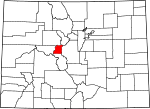
Larimer County 069 Fort Collins 1861-11-01 Created as one of the 17 original counties of the Territory of Colorado. Named in honor of William Larimer, a pioneer entrepreneur. 299,630 2,631.75 sq mi
(6,816 km2)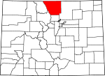
Las Animas County 071 Trinidad 1866-02-09 Split from Huerfano County. Named for the Animas River, which was originally named el Rio de las Animas Perdidas, which is Spanish for the River of the Souls in Purgatory. 15,507 4,773.27 sq mi
(12,363 km2)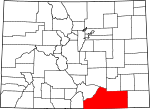
Lincoln County 073 Hugo 1889-04-11 Split from Elbert and Bent counties. Named in honor of Abraham Lincoln, the sixteenth President of the United States. 5,467 2,585.21 sq mi
(6,696 km2)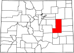
Logan County 075 Sterling 1887-02-25 Split from Weld County. Named in honor of John Alexander Logan, a U.S. Army general and U.S. Senator from Illinois. 22,709 1,845.31 sq mi
(4,779 km2)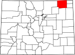
Mesa County 077 Grand Junction 1883-02-14 Split from Gunnison County. Named for the mesa formations which are widespread through the area. 146,723 3,345.69 sq mi
(8,665 km2)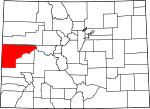
Mineral County 079 Creede 1893-03-27 Split from Hinsdale, Rio Grande, and Saguache counties. Named from the plentiful mineral deposits found in the area. 712 878.16 sq mi
(2,274 km2)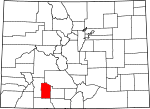
Moffat County 081 Craig 1911-02-27 Split from Routt County. Named in honor of railroad pioneer David H. Moffat. 13,795 4,755.86 sq mi
(12,318 km2)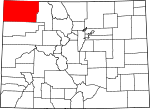
Montezuma County 083 Cortez 1889-04-16 Split from La Plata County. Named in honor of Aztec leader Moctezuma II. Ruins in the area were once thought to be Aztec. 25,535 2,035.80 sq mi
(5,273 km2)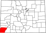
Montrose County 085 Montrose 1883-02-11 Split from Gunnison County. Named for the town of Montrose, which in turn was probably named from the novel A Legend of Montrose, published in 1819 by Walter Scott. 41,276 2,246.43 sq mi
(5,818 km2)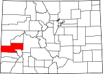
Morgan County 087 Fort Morgan 1889-02-19 Split from Weld County. Named for old Fort Morgan, which in turn was named in honor of U.S. Army Colonel Christopher A. Morgan. 28,159 1,293.83 sq mi
(3,351 km2)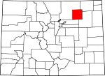
Otero County 089 La Junta 1889-03-25 Split from Bent County. Named in honor of Miguel A. Otero of the prominent Otero family of the Southwest. 18,831 1,267.66 sq mi
(3,283 km2)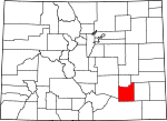
Ouray County 091 Ouray 1877-01-18 Split from Hinsdale and Lake counties. Renamed Uncompaghre County for four days from 1883-02-27, to 1883-03-02. Named in honor of Ouray, a Ute Native American leader. 4,436 542.30 sq mi
(1,405 km2)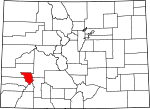
Park County 093 Fairplay 1861-11-01 Created as one of the 17 original counties of the Territory of Colorado. Named for South Park which occupies most of the county. 16,206 2,209.36 sq mi
(5,722 km2)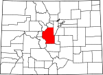
Phillips County 095 Holyoke 1889-03-27 Split from Logan County. Named in honor of R.O. Phillips, secretary of the Lincoln Land Company, which sold farmsteads in the area. 4,442 688.30 sq mi
(1,783 km2)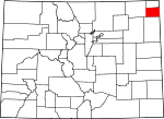
Pitkin County 097 Aspen 1881-02-23 Split from Gunnison County. Named in honor of Frederick Walker Pitkin, the second Governor of the State of Colorado. 17,148 970.37 sq mi
(2,513 km2)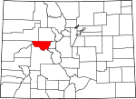
Prowers County 099 Lamar 1889-04-11 Split from Bent County. Named in honor of John W. Prowers, a pioneer of the Arkansas River valley. 12,551 1,645.37 sq mi
(4,261 km2)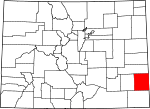
Pueblo County 101 Pueblo 1861-11-01 Created as one of the 17 original counties of the Territory of Colorado. Named for historic town of Pueblo. Pueblo is a Spanish word meaning village or people. 159,063 2,396.77 sq mi
(6,208 km2)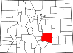
Rio Blanco County 103 Meeker 1889-03-25 Split from Garfield County. Named for the White River, which was originally named Rio Blanco in Spanish. 6,666 3,226.24 sq mi
(8,356 km2)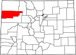
Rio Grande County 105 Del Norte 1874-02-10 Split from Costilla County and Conejos County counties. Named for the Rio Grande, which flows through the area. 11,982 913.10 sq mi
(2,365 km2)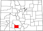
Routt County 107 Steamboat Springs 1877-01-29 Split from Grand County. Named in honor of John Long Routt, the first Governor of the State of Colorado. 23,509 2,362.11 sq mi
(6,118 km2)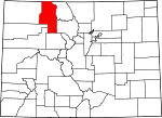
Saguache County 109 Saguache 1866-12-29 Split from Lake and Costilla counties. Name comes from a Ute language word meaning "blue earth" or "water at blue earth".[7] 6,108 3,168.32 sq mi
(8,206 km2)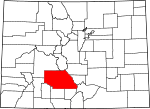
San Juan County 111 Silverton 1876-01-31 Split from Lake County. Named for the San Juan River and San Juan Mountains, which in turn were named for Saint John the Evangelist. 699 388.99 sq mi
(1,007 km2)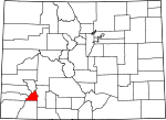
San Miguel County 113 Telluride 1883-03-02 Split from San Juan County. Named for the San Miguel River and San Miguel Mountains, which in turn were named for Saint Michael the Archangel. 7,359 1,290.76 sq mi
(3,343 km2)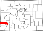
Sedgwick County 115 Julesburg 1889-04-09 Split from Logan County. Named for Fort Sedgwick, which, in turn, was named for U.S. Army General John Sedgwick. 2,379 548.83 sq mi
(1,421 km2)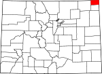
Summit County 117 Breckenridge 1861-11-01 Created as one of the 17 original counties of the Territory of Colorado. Named for the many high mountain summits in the area. 27,994 618.92 sq mi
(1,603 km2)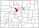
Teller County 119 Cripple Creek 1899-03-23 Split from El Paso and Fremont counties. Named in honor of Henry Moore Teller, a U.S. Senator from Colorado and United States Secretary of the Interior. 23,350 558.58 sq mi
(1,447 km2)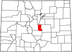
Washington County 121 Akron 1887-02-09 Split from Weld County. Named in honor of George Washington, the first President of the United States. 4,814 2,522.90 sq mi
(6,534 km2)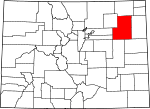
Weld County 123 Greeley 1861-11-01 Created as one of the 17 original counties of the Territory of Colorado. Named in honor of Lewis Ledyard Weld, the first Secretary of the Territory of Colorado. 252,825 4,013.84 sq mi
(10,396 km2)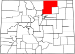
Yuma County 125 Wray 1889-03-15 Split from Washington County. Named for the Quechan (Yuma) Nation of Native Americans. 10,043 2,369.61 sq mi
(6,137 km2)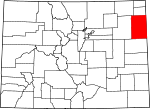
See also
 United States census statistical areas by state, district, or territoryASMPGUVI
- State of Colorado
- Colorado census designated places
- Colorado census statistical areas
- Colorado counties
- Colorado counties ranked by per capita income
- List of counties in Colorado
- Wikimedia Commons: Counties in Colorado
- Colorado metropolitan areas
- Colorado municipalities
- Geography of Colorado
- History of Colorado
- List of cities and towns in Colorado
- List of forts in Colorado
- List of ghost towns in Colorado
- List of places in Colorado
- Outline of Colorado
- Index of Colorado-related articles
- Wikimedia Commons: Colorado
- United States Census Bureau
References
- ^ "EPA County FIPS Code Listing". EPA.gov. http://www.epa.gov/enviro/html/codes/co.html. Retrieved 2008-02-23.
- ^ The FIPS county code is the five-digit Federal Information Processing Standard (FIPS) code which uniquely identifies counties and county equivalents in the United States. The three-digit number is unique to each individual county within a state, but to be unique within the entire United States, it must be prefixed by the state code. This means that, for example, while Adams County, Colorado is 001, Belknap County, New Hampshire and Alachua County, Florida are also 001. To uniquely identify Adams County, Colorado, one must use the state code of 08 plus the county code of 001; therefore, the unique nationwide identifier for Adams County, Colorado is 08001. The links in the column FIPS County Code are to the Census Bureau Info page for that county.
- ^ "Colorado County Seats". State of Colorado, Department of Public Health and Environment. 2007-01-30. http://www.cdphe.state.co.us/hs/cntyseat.html. Retrieved 2007-01-30.
- ^ a b National Association of Counties. "NACo - Find a county". http://www.naco.org/Template.cfm?Section=Find_a_County&Template=/cffiles/counties/state.cfm&state.cfm&statecode=CO. Retrieved 2008-04-30.[dead link]
- ^ a b c "Colorado Government History". State of Colorado, Department of Personnel & Administration, Colorado State Archives. 2001-04-18. http://www.colorado.gov/dpa/doit/archives/arcgov.html. Retrieved 2008-09-25.
- ^ "2010 United States Census website". United States Census Bureau, Population Division. http://2010.census.gov/. Retrieved April 22, 2011.
- ^ Saguache is
 /səˈwætʃ/. This name comes from a Ute language word meaning "blue earth" or "water at blue earth". The Spanish language version of this name is usually spelled Saguache, while the English language version is usually spelled Sawatch.
External links
List of U.S. counties and county-equivalents
by political division (state / federal district)- Alabama
- Alaska
- Arizona
- Arkansas
- California
- Colorado
- Connecticut
- Delaware
- District of Columbia
- Florida
- Georgia
- Hawaii
- Idaho
- Illinois
- Indiana
- Iowa
- Kansas
- Kentucky
- Louisiana
- Maine
- Maryland
- Massachusetts
- Michigan
- Minnesota
- Mississippi
- Missouri
- Montana
- Nebraska
- Nevada
- New Hampshire
- New Jersey
- New Mexico
- New York
- North Carolina
- North Dakota
- Ohio
- Oklahoma
- Oregon
- Pennsylvania
- Rhode Island
- South Carolina
- South Dakota
- Tennessee
- Texas
- Utah
- Vermont
- Virginia
- Washington
- West Virginia
- Wisconsin
- Wyoming
Categories:- Colorado counties
- Colorado-related lists
- Lists of U.S. counties by state
- Local government in Colorado
- State of Colorado


Wikimedia Foundation. 2010.