- Thornton, Colorado
Infobox Settlement
official_name = City of Thornton, Colorado
other_name =
native_name =
nickname =
settlement_type =City
motto =
imagesize =
image_caption =
flag_size =
image_
seal_size =
image_shield =
shield_size =
image_blank_emblem =
blank_emblem_type =
blank_emblem_size =
imagesize =
image_caption =
flag_size =
image_
seal_size =
image_shield =
shield_size =
image_blank_emblem =
blank_emblem_type =
blank_emblem_size =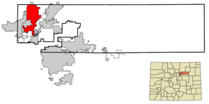
mapsize = 250x200px
map_caption = Location in Adams County and Weld County of theState of Colorado
mapsize1 =
map_caption1 =
image_dot_
dot_mapsize =
dot_map_caption =
dot_x =
dot_y =
pushpin_
pushpin_label_position =
pushpin_map_caption =
pushpin_mapsize =
subdivision_type = Country
subdivision_name = USA
subdivision_type1 = State
subdivision_name1 = flag|Colorado|name=State of Colorado
subdivision_type2 = Countiescite web | url = http://www.dola.state.co.us/dlg/local_governments/municipalities.html | title = Active Colorado Municipalities | format =HTML | publisher = State of Colorado, Department of Local Affairs | accessdate = 2007-09-01]
subdivision_name2 = Adams County Weld County
subdivision_type3 =
subdivision_name3 =
subdivision_type4 =
subdivision_name4 =
government_footnotes =
government_type = Home Rule Municipality
leader_title =
leader_name =
leader_title1 =
leader_name1 =
leader_title2 =
leader_name2 =
leader_title3 =
leader_name3 =
leader_title4 =
leader_name4 =
established_title =
established_date =
established_title2 =
established_date2 =
established_title3 = Incorporated
established_date3 =June 12 ,1956 cite web | url = http://www.colorado.gov/dpa/doit/archives/muninc.html | title = Colorado Municipal Incorporations | format =HTML | publisher = State of Colorado, Department of Personnel & Administration, Colorado State Archives | date =2004-12-01 | accessdate = 2007-09-02]
named_for =Daniel I.J. Thornton
area_magnitude =
unit_pref = Imperial
area_footnotes =
area_total_km2 = 70.4
area_land_km2 = 69.6
area_water_km2 = 0.9
area_total_sq_mi = 27.2
area_land_sq_mi = 26.9
area_water_sq_mi = 0.3
area_water_percent =
area_urban_km2 =
area_urban_sq_mi =
area_metro_km2 =
area_metro_sq_mi =
area_blank1_title =
area_blank1_km2 =
area_blank1_sq_mi =
population_as_of = 2006
population_footnotes = cite web | date =June 28 2007 | url = http://www.census.gov/popest/cities/tables/SUB-EST2005-04-08.csv | title = Annual Estimates of the Population for All Incorporated Places in Colorado | format = CSV | work = 2006 Population Estimates | publisher =U.S. Census Bureau , Population Division | accessdate = 2007-12-10]
population_note =
population_total = 117155
population_density_km2 = 1184.1
population_density_sq_mi = 3066.7
population_metro =
population_density_metro_km2 =
population_density_metro_sq_mi =
population_urban =
population_density_urban_km2 =
population_density_urban_sq_mi =
population_blank1_title =
population_blank1 =
population_density_blank1_km2 =
population_density_blank1_sq_mi =
timezone = MST
utc_offset = -7
timezone_DST = MDT
utc_offset_DST = -6
latd = 39 |latm = 54 |lats = 11 |latNS = N
longd = 104 |longm = 57 |longs = 16 |longEW = W
elevation_footnotes = GR|3
elevation_m = 1631
elevation_ft = 5351
postal_code_type =ZIP code scite web|url = http://zip4.usps.com/zip4/citytown.jsp | title = ZIP Code Lookup| format =JavaScript /HTML | publisher =United States Postal Service | accessdate=2008-01-06]
postal_code = Denver 80221, 80229, 80233, 80241, 80260 Brighton 80602
area_code = Both 303 and 720
blank_name = FIPS code
blank_info = 08-77290
blank1_name = GNIS feature ID
blank1_info = [http://geonames.usgs.gov/pls/gnispublic/f?p=gnispq:3:::NO::P3_FID:0181265 0181265]
blank2_name = Highways
blank2_info = I-25, I-76, SH 7, SH 44, SH 224,E-470
website = [http://www.cityofthornton.net/ www.cityofthornton.net]
footnotes =
Sixth most populous Colorado city
The City of Thornton is a suburb of the Denver-Aurora Metropolitan Statistical Area, and a Home Rule Municipality located in Adams County and Weld County,
Colorado ,United States . TheUnited States Census Bureau estimates that the city population was 109,155 in 2006. Thornton is the sixth most populous city in the State of Colorado and the 225th most populous city in theUnited States .History
Modern day Thornton consisted solely of farmland until
1953 , when Sam Hoffman purchased a lot off Washington Street about seven miles north of Denver. The town he laid out was the first fully planned community in Adams County and the first to offer fullmunicipal services from a singletax levy, including recreation services and free trash pickup. Thornton was named in honor of Colorado GovernorDan Thornton .The Thornton Community Association (TCA) was formed in
1954 to help guide the new community's development. By the end of1955 , Thornton had 5,500 residents in over 1,200 homes. The TCA was instrumental in Thornton's 1956 incorporation as a city. Oyer G. Leary was elected the first mayor. [cite book | title = Adams County: Crossroads of the West | last = Wagner | first = Alvin | volume = Volume II | publisher = Board of Adams County Commissioners | location = Brighton, Colorado | chapter = Thornton Was First Planned Community | year = 1977 | id = ISBN 0-930952-01-4 ]Geography
Thornton is located at coor dms|39|54|11|N|104|57|16|W|city (39.903043, -104.954406)GR|1.
According to the
United States Census Bureau , the city has a total area of 27.2square mile s (70.4km² ), of which, 26.9 square miles (69.6 km²) of it is land and 0.3 square miles (0.9 km²) of it (1.25%) is water.Thornton is a
suburb north ofDenver, Colorado , on the east side of I-25. By 2025, it will contain most of the North Metro Corridor in Denver's FasTrackscommuter rail network.Demographics
As of the
census GR|2 of 2000, there were 82,384 people, 28,882 households, and 21,517 families residing in the city. Thepopulation density was 3,066.7 people per square mile (1,184.2/km²). There were 29,573 housing units at an average density of 1,100.9/sq mi (425.1/km²). The racial makeup of the city was 82.71% White, 1.46% African American, 1.12% Native American, 2.50% Asian, 0.11% Pacific Islander, 8.96% from other races, and 3.14% from two or more races. Hispanic or Latino of any race were 21.34% of the population.There were 28,882 households out of which 42.3% had children under the age of 18 living with them, 57.8% were married couples living together, 11.5% had a female householder with no husband present, and 25.5% were non-families. 18.7% of all households were made up of individuals and 3.8% had someone living alone who was 65 years of age or older. The average household size was 2.83 and the average family size was 3.25.
In the city the population was spread out with 30.0% under the age of 18, 9.6% from 18 to 24, 36.0% from 25 to 44, 18.8% from 45 to 64, and 5.6% who were 65 years of age or older. The median age was 31 years. For every 100 females there were 99.0 males. For every 100 females age 18 and over, there were 97.2 males.
The median income for a household in the city was $54,445, and the median income for a family was $58,742. Males had a median income of $40,098 versus $29,982 for females. The
per capita income for the city was $41,471. About 4.0% of families and 5.2% of the population were below thepoverty line , including 6.4% of those under age 18 and 4.5% of those age 65 or over.ee also
*
Adams County, Colorado
*Adams County School District 12
*Colorado municipalities
*Denver-Aurora Metropolitan Statistical Area
*Denver-Aurora-Boulder Combined Statistical Area
*Daniel I.J. Thornton
*Front Range Urban Corridor
*Greeley Metropolitan Statistical Area
*State of Colorado
*Weld County, Colorado References
External links
* [http://www.cityofthornton.net/ City of Thornton website]
*MySpace|cityofthornton|City of Thornton
** [http://www.dot.state.co.us/App_DTD_DataAccess/Downloads/CityMaps/Thornton.pdf CDOT map of the City of Thornton]
Wikimedia Foundation. 2010.