- Clear Creek (Colorado)
-
Clear Creek[1] 
US 6 in Clear Creek Canyon west of GoldenOrigin Clear Creek County, Colorado
39°40′29″N 105°55′23″W / 39.67472°N 105.92306°WMouth Confluence with South Platte
39°49′39″N 104°56′57″W / 39.8275°N 104.94917°WCoordinates: 39°49′39″N 104°56′57″W / 39.8275°N 104.94917°WProgression South Platte—Platte—
Missouri—MississippiLength 66 mi (106 km) Mouth elevation 5,092 ft (1,552 m) 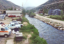 Clear Creek at Georgetown in 2003
Clear Creek is a tributary of the South Platte River, approximately 66 miles (106 km) long,[2] in north central Colorado in the United States. The creek flows through Clear Creek Canyon in the Rocky Mountains directly west of Denver, descending through a long gorge to emerge on the Colorado Eastern Plains where it joins the South Platte. The creek is famous as the location of the most intense early mining activity during the Colorado Gold Rush of 1859. Mountain man Jim Baker had a cabin on the creek from 1873 until his death in 1898. The creek provided the route of the Colorado Central Railroad, and later for U.S. Highway 6 and Interstate 70 as they ascend to the Continental Divide west of Denver.
Contents
Geography
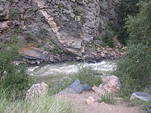 Another view of Clear Creek cutting through jagged rocks west of Golden
The creek rises at the continental divide near Loveland Pass in the Front Range, northwest of Grays Peak in western Clear Creek County. It descends eastward through Clear Creek Canyon past the towns of Silver Plume, Georgetown, and Idaho Springs, all of which were founded as mining camps in the 1859 gold rush. Within the canyon it receives numerous smaller tributary creeks that descend from the rugged mountains on either side.
At the mouth of the canyon, the creek passes through the town of Golden, past the Coors brewery. East of the foothills, it flows through the northwest part of the Denver Metropolitan Area, passing through north Lakewood and Wheat Ridge, then roughly along the route of Interstate 76. Along this section it is largely an ignored urban stream, with an undeveloped floodplain. Part of the creek path forms a wooded park with bicycle/foot path. It passes under Interstate 25 between its junction with Interstate 70 and U.S. Highway 36 (the Boulder Turnpike). It joins the South Platte from the west in southeast Thornton, near the junction of Interstate 76 and State Highway 224.
History
Clear Creek was originally named Cannonball Creek as early as 1820, called so by the French hunters of the expedition of Stephen H. Long, after the river rocks in its bed. In the 1830s it became known as Vasquez Fork, also Vasquez River, after the fur trader Louis Vasquez who had his fort at the mouth of the river and trapped along it. It gained its present name from the gold rushers in 1859.[citation needed]
References
- ^ "Clear Creek". Geographic Names Information System, U.S. Geological Survey. http://geonames.usgs.gov/pls/gnispublic/f?p=gnispq:3:::NO::P3_FID:181805. Retrieved 2011-01-26.
- ^ U.S. Geological Survey. National Hydrography Dataset high-resolution flowline data. The National Map, accessed March 25, 2011
See also
Categories:- Canyons and gorges of Colorado
- Rivers of Colorado
- U.S. Route 6
- Geography of Clear Creek County, Colorado
- Geography of Jefferson County, Colorado
- Golden, Colorado
- Wheat Ridge, Colorado
- Geography of Adams County, Colorado
- Tributaries of the Platte River
Wikimedia Foundation. 2010.