- Idaho Springs, Colorado
Infobox Settlement
official_name = City of Idaho Springs, Colorado
other_name =
native_name =
nickname =
settlement_type =City
motto =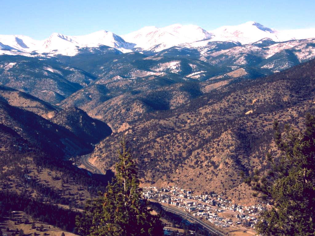
imagesize =
image_caption = Idaho Springs as seen from the surrounding mountains.
flag_size =
image_
seal_size =
image_shield =
shield_size =
image_blank_emblem =
blank_emblem_type =
blank_emblem_size =
flag_size =
image_
seal_size =
image_shield =
shield_size =
image_blank_emblem =
blank_emblem_type =
blank_emblem_size =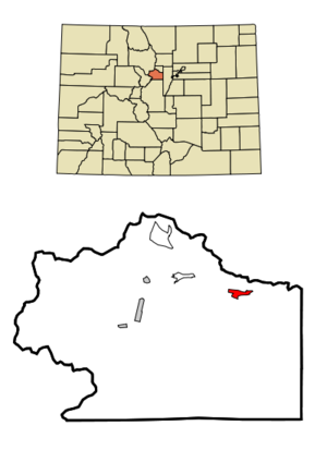
mapsize = 250x200px
map_caption = Location in Clear Creek County and theState of Colorado
mapsize1 =
map_caption1 =
image_dot_
dot_mapsize =
dot_map_caption =
dot_x =
dot_y =
pushpin_
pushpin_label_position =
pushpin_map_caption =
pushpin_mapsize =
subdivision_type = Country
subdivision_name = USA
subdivision_type1 = State
subdivision_name1 = flag|Colorado|name=State of Colorado
subdivision_type2 = County
subdivision_name2 = Clear Creek Countycite web | url = http://www.dola.state.co.us/dlg/local_governments/municipalities.html | title = Active Colorado Municipalities | format =HTML | publisher =State of Colorado , Department of Local Affairs | accessdate = 2007-12-06]
subdivision_type3 =
subdivision_name3 =
subdivision_type4 =
subdivision_name4 =
government_footnotes =
government_type = Statutory City
leader_title = Mayor
leader_name = Dennis Lunbery [cite web | url = http://www.idahospringsco.com/council.html | title = City Council - City of Idaho Springs | format =HTML | publisher = City of Idaho Springs | accessdate = 2007-10-12]
leader_title1 =
leader_name1 =
leader_title2 =
leader_name2 =
leader_title3 =
leader_name3 =
leader_title4 =
leader_name4 =
established_title = Founded
established_date = 1859
established_title2 = Incorporated
established_date2 =1885-11-15 cite web | url = http://www.colorado.gov/dpa/doit/archives/muninc.html | title = Colorado Municipal Incorporations | format =HTML | publisher = State of Colorado, Department of Personnel & Administration, Colorado State Archives | date =2004-12-01 | accessdate = 2007-09-02]
established_title3 =
established_date3 =
area_magnitude =
unit_pref = Imperial
area_footnotes =
area_total_km2 = 2.7
area_land_km2 = 2.7
area_water_km2 = 0
area_total_sq_mi = 1
area_land_sq_mi = 1
area_water_sq_mi = 0
area_water_percent =
area_urban_km2 =
area_urban_sq_mi =
area_metro_km2 =
area_metro_sq_mi =
area_blank1_title =
area_blank1_km2 =
area_blank1_sq_mi =
population_as_of = 2000
population_footnotes =
population_note =
population_total = 1889
population_density_km2 = 699.6
population_density_sq_mi = 1889
population_metro =
population_density_metro_km2 =
population_density_metro_sq_mi =
population_urban =
population_density_urban_km2 =
population_density_urban_sq_mi =
population_blank1_title =
population_blank1 =
population_density_blank1_km2 =
population_density_blank1_sq_mi =
timezone = MST
utc_offset = -7
timezone_DST = MDT
utc_offset_DST = -6
latd = 39 |latm = 44 |lats = 33 |latNS = N
longd = 105 |longm = 30 |longs = 52 |longEW = W
elevation_footnotes = GR|3
elevation_m = 2294
elevation_ft = 7526
postal_code_type =ZIP code cite web | url = http://zip4.usps.com/zip4/citytown.jsp | title = ZIP Code Lookup| format =JavaScript /HTML | publisher =United States Postal Service | accessdate = October 12 | accessyear = 2007]
postal_code = 80452
area_code = Both 303 and 720
blank_name = FIPS code
blank_info = 08-38370
blank1_name = GNIS feature ID
blank1_info = [http://geonames.usgs.gov/pls/gnispublic/f?p=gnispq:3:::NO::P3_FID:204710 204710]
website = [http://www.idahospringsco.com/ City of Idaho Springs]
footnotes =The historic City of Idaho Springs is a Statutory City that is the most populous city in Clear Creek County,
Colorado ,United States . The city population was 1,889 at theU.S. Census 2000 . Idaho Springs is located in Clear Creek Canyon, in the mountains upstream from Golden about 30 miles west of Denver.Founded in 1859 by prospectors during the early days of the
Pike's Peak Gold Rush , the town became a center of the regional mining district throughout the late 19th century. As you pass through Idaho Springs the entrance of the Argo tunnel is visible across the canyon. This long tunnel drained and gave access to many lodes between Idaho Springs and Central City. In the late 20th century the town evolved in a tourist center alongU.S. Highway 6 andU.S. Highway 40 , which ascend Clear Creek Canyon through the historical mining district.The town today is squeezed along the north side of
Interstate 70 , with a historical downtown on its western end and a strip of tourist-related businesses on its eastern end. It also serves as abedroom community for workers at theLoveland Ski Area farther up the canyon. The town today is the largest community in Clear Creek County, but for historical reasons the county seat has remained at Georgetown.Beau Jo's , a well-known pizza restaurant in Colorado was founded in Idaho Springs in 1973 and still maintains its original location, though the company headquarters is now inLakewood, Colorado History
On January 5, 1859, during the
Colorado gold rush , prospectorGeorge A. Jackson discovered placer gold at the present site of Idaho Springs, where Chicago Creek empties into Clear Creek. It was the first substantial gold discovery in Colorado. Jackson, aMissouri native with experience in theCalifornia gold fields, was drawn to the area by clouds of steam rising from some nearbyhot spring s. Jackson kept his find secret for several months, but after he paid for some supplies with gold dust, others rushed to Jackson's diggings. The settlement was first called Spanish Bar, later renamed Idaho Springs, after the hot springs. [Robert L. Brown (1985) "The Great Pikes Peak Gold Rush", Caldwell, Ida.: Caxton, p.26-32.]The first placer discoveries were soon followed by discoveries of gold veins in the rocks of the canyon walls on both sides of Clear Creek.
Hard rock mining became the mainstay of the town long after the gold-bearing gravels were exhausted.A strike by Idaho Springs miners demanding the
eight-hour day in May 1903 erupted into violence, and was one local struggle in a much broader fight called theColorado Labor Wars .Geography
Idaho Springs is located at coor dms|39|44|33|N|105|30|52|W|city (39.742456, -105.514391)GR|1.
According to the
United States Census Bureau , the city has a total area of 1.0 square miles (2.7 km²), all of it land.Demographics
As of the
census GR|2 of 2000, there were 1,889 people, 841 households, and 485 families residing in the city. Thepopulation density was 1,820.1 people per square mile (701.3/km²). There were 904 housing units at an average density of 871.0/sq mi (335.6/km²). The racial makeup of the city was 94.71% White, 0.74% Black or African American, 1.06% Native American, 0.48% Asian, 1.54% from other races, and 1.48% from two or more races. 5.03% of the population were Hispanic or Latino of any race.There were 841 households out of which 27.1% had children under the age of 18 living with them, 42.8% were married couples living together, 10.9% had a female householder with no husband present, and 42.3% were non-families. 33.2% of all households were made up of individuals and 8.4% had someone living alone who was 65 years of age or older. The average household size was 2.25 and the average family size was 2.87.
In the city the population was spread out with 23.1% under the age of 18, 9.1% from 18 to 24, 30.3% from 25 to 44, 28.0% from 45 to 64, and 9.5% who were 65 years of age or older. The median age was 39 years. For every 100 females there were 105.5 males. For every 100 females age 18 and over, there were 103.9 males.
The median income for a household in the city was $39,643, and the median income for a family was $48,790. Males had a median income of $35,446 versus $22,688 for females. The
per capita income for the city was $20,789. About 2.2% of families and 6.7% of the population were below thepoverty line , including 5.4% of those under age 18 and 13.4% of those age 65 or over.Famous residents
Jennifer Whalen is a professional mountain bike racer who won the 2005NORBA National Championship in the Super D category. She has been a resident of Idaho Springs since 2002.Points of Interest
*Argo Tunnel, Gold Mill, and Museum - The mill and museum are open for tours. [http://www.historicargotours.com/history.html]
*Statue of cartoon characterSteve Canyon [http://www.roadsideamerica.com/attract/COIDAstevecanyon.html]
*Phoenix Gold mine - offers underground tours [http://www.phoenixgoldmine.com/]
*Edgar Experimental mine - Owned and Operated by theColorado School of Mines to train mining engineering students. The mine is open for tours. [http://www.mines.edu/Academic/mining/edgar_mine.htm]
*Indian Hot Springs [http://www.indianspringsresort.com/]ee also
*
State of Colorado
**Colorado cities and towns
***Colorado municipalities
**Colorado counties
***Clear Creek County, Colorado
**Colorado geography
***Clear Creek (Colorado)
**Colorado history
***Pike's Peak Gold Rush
***Territory of Jefferson
***Territory of Colorado
**Colorado metropolitan areas
***Boulder Metropolitan Statistical Area
***Denver-Aurora-Boulder Combined Statistical Area
***North Central Colorado Urban Area
***Front Range Urban Corridor
*United States Forest Service
**Arapaho National Forest References
External links
* [http://www.idahospringsco.com/ City of Idaho Springs website]
** [http://www.dot.state.co.us/App_DTD_DataAccess/Downloads/CityMaps/Idaho%20Springs.pdf CDOT map of the City of Idaho Springs]
* [http://www.westernmininghistory.com/towns/colorado/idaho-springs/ Idaho Springs Photos and Information at Western Mining History]
Wikimedia Foundation. 2010.