- Denver, Colorado
Infobox Settlement
official_name = City and County of Denver
other_name =
native_name =
nickname = The Mile-High City, Queen City of the Plains, The 303, D-Town
settlement_type = City and County
motto =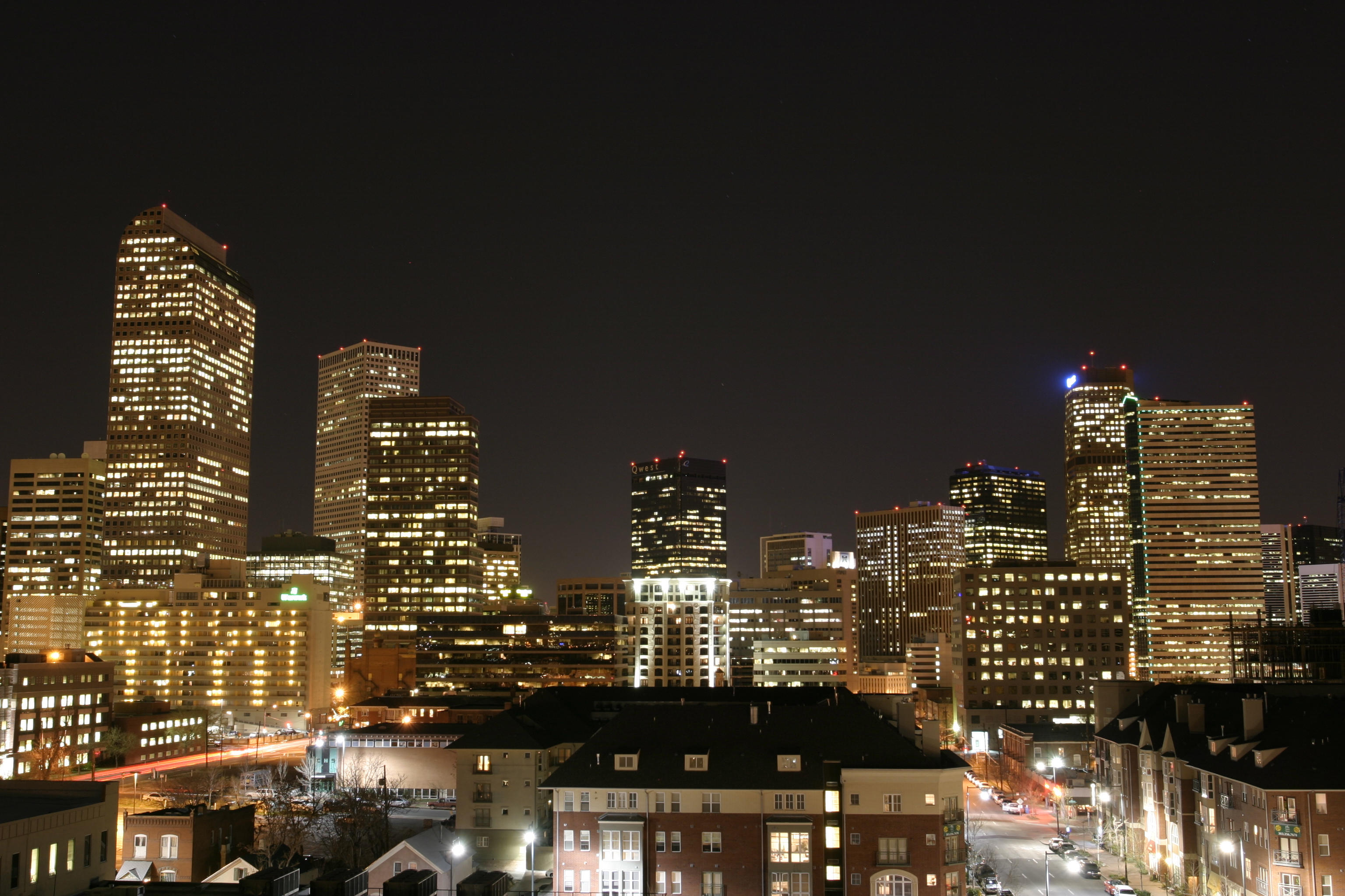
imagesize =
image_caption =
flag_size = 125px
image_
seal_size = 75px
image_shield =
shield_size =
image_blank_emblem =
blank_emblem_size =.png)
mapsize = 250x200px
map_caption = Location of Denver in theState of Colorado 
mapsize1 =
map_caption1 = Location of Colorado in the United States
image_dot_
dot_mapsize =
dot_map_caption =
dot_x =
dot_y =
pushpin_
pushpin_label_position =
pushpin_map_caption =
pushpin_mapsize =
subdivision_type = Country
subdivision_name = USA
subdivision_type1 = State
subdivision_name1 = flag|Colorado|name=State of Colorado
subdivision_type2 = City and County
subdivision_name2 = Denvercite web | url = http://www.dola.state.co.us/dlg/local_governments/municipalities.html | title = Active Colorado Municipalities | format =HTML | publisher = State of Colorado, Department of Local Affairs | accessdate = 2007-11-16]
subdivision_type3 =
subdivision_name3 =
subdivision_type4 =
subdivision_name4 =
government_footnotes =
government_type = Consolidated City and County
leader_title = Mayor
leader_name =John Hickenlooper (D)
leader_title1 =
leader_name1 =
leader_title2 =
leader_name2 =
leader_title3 =
leader_name3 =
leader_title4 =
leader_name4 =
established_title = Founded
established_date =1858-11-22 , as Denver City, K.T.
established_title2 = Incorporated
established_date2 =1861-11-07 , as Denver City, C.T.cite web | url = http://www.colorado.gov/dpa/doit/archives/muninc.html | title = Colorado Municipal Incorporations | format =HTML | publisher = State of Colorado, Department of Personnel & Administration, Colorado State Archives | date =2004-12-01 | accessdate = 2007-12-05]
established_title3 = Consolidated
established_date3 =1902-11-15 , as the City and County of Denver
named_for =James William Denver
area_magnitude =
unit_pref = Imperial
area_footnotes =
area_total_km2 = 401.3
area_land_km2 = 397.2
area_water_km2 = 4.1
area_total_sq_mi = 154.9
area_land_sq_mi = 153.3
area_water_sq_mi = 1.6
area_water_percent = 1.03
area_urban_km2 =
area_urban_sq_mi =
area_metro_km2 =
area_metro_sq_mi = 8414.4
population_as_of = 2006
population_footnotes =
population_note =
population_total = 588349
population_density_km2 = 1481
population_density_sq_mi = 3838
population_metro = 2464866
population_density_metro_km2 =
population_density_metro_sq_mi =
population_urban =
population_density_urban_km2 =
population_density_urban_sq_mi =
population_blank1_title =
population_blank1 =
population_density_blank1_km2 =
population_density_blank1_sq_mi =
timezone = MST
utc_offset = -7
timezone_DST = MDT
utc_offset_DST = -6
latd = 39 |latm = 44 |lats = 21 |latNS = N
longd = 104 |longm = 59 |longs = 5 |longEW = W
coordinates_type= region:US_type:city
elevation_footnotes =
elevation_m = 1609
elevation_ft = 5280
postal_code_type =ZIP code s
postal_code = 80201-80212, 80214-80239, 80241, 80243-80244, 80246-80252, 80256-80266, 80271, 80273-80274, 80279-80281, 80290-80291, 80293-80295, 80299, 80012, 80014, 80022, 80033, 80123, 80127cite web | date = August 18, 2007 | url = http://zip4.usps.com/zip4/citytown.jsp | title = ZIP Code Lookup| format =JavaScript /HTML | publisher =United States Postal Service | accessmonthday = October 16 | accessyear = 2007]
area_code = Both 303 and 720
blank_name = FIPS code
blank_info = 08-20000
blank1_name = GNIS feature ID
blank1_info = 0201738
blank2_name = Highways
blank2_info = I-25, I-70, I-76, I-225, I-270, US 6, US 40, US 85, US 285, US 287, SH 2, SH 26, SH 30, SH 35, SH 83, SH 88, SH 95, SH 121, SH 177, SH 265, SH 470,E-470
website = [http://www.denvergov.org City and County of Denver]
footnotes =The City and County of Denver (pronounced /ˈdɛnvɚ/) is the
capital and the most populous city ofColorado , in the United States. Denver is aconsolidated city-county located in the South Platte River Valley on the High Plains just east of theFront Range of the Southern Rocky Mountains. The Denver downtown district is located immediately east of the confluence of Cherry Creek with theSouth Platte River , approximately convert|15|mi|km|0|sp=us east of thefoothills of the Rocky Mountains. Denver isnickname d the "Mile-High City" because its officialelevation is exactly one mile, or 5,280 feet (1,609 m) above sea level.cite web | url = http://www.denvergov.org/AboutDenver/today_factsguide.asp | title = Denver Facts Guide - Today | publisher = The City and County of Denver | accessdate = 2007-03-19] The 105th meridian west of Greenwich passes throughDenver Union Station , making it the reference point for theMountain Time Zone .The
United States Census Bureau estimates that the population of the City and County of Denver was 588,349 on July 1, 2007, making it the 26th most populous U.S. city.cite web | url = http://www.census.gov/popest/counties/files/CO-EST2007-ALLDATA.csv | title = Annual County Population Estimates and Estimated Components of Change: April 1, 2000 to July 1, 2007 (CO-EST2007-alldata) | format = CSV | work = 2007 Population Estimates | publisher =United States Census Bureau , Population Division | date =2008-03-20 | accessdate = 2008-03-27] The 5-countyDenver-Aurora Metropolitan Statistical Area had an estimated 2007 population of 2,464,866 and ranked as the 21st most populous U.S. metropolitan statistical area,cite web|url=http://www.census.gov/population/estimates/metro_general/2007/CBSA-EST2007-alldata.csv|title=Annual Estimates of the Population of Metropolitan and Micropolitan Statistical Areas: April 1, 2000 to July 1, 2007|format=CSV|work=2007 Population Estimates|publisher=United States Census Bureau , Population Division|date=2008-03-27 |accessdate=2008-03-27] and the 12-countyDenver-Aurora-Boulder Combined Statistical Area had an estimated 2007 population of 2,998,878 and ranked as the 17th most populous U.S. metropolitan area.cite web|url=http://www.census.gov/population/estimates/metro_general/2007/CSA-EST2007-alldata.csv|title=Annual Estimates of the Population of Combined Statistical Areas: April 1, 2000 to July 1, 2007|format=CSV|work=2007 Population Estimates|publisher=United States Census Bureau , Population Division|date=2008-03-27 |accessdate=2008-03-27] The 18-countyFront Range Urban Corridor had an estimated 2007 population of 4,166,855. It is also the second largest city in the Mountain West after Phoenix. The city has the 10th largestcentral business district in the United States. [ [http://www.denver.org/metro/media/press-kit-detail?pk=10 Press Kit Detail ] ]History
Denver City was founded in November 1858 as a mining town during the
Pikes Peak Gold Rush in westernKansas Territory . [cite web | author= | date=January 1, 2006| title=Denver: The Rocky Mountain metropolis time line| format= | work=The City and County of Denver| url=http://www.denvergov.org/aboutdenver/history_timeline.asp|accessdate=2006-08-30] That summer, a group of gold prospectors from Lawrence,Kansas , arrived and establishedMontana City on the banks of theSouth Platte River . This was the first settlement in what was later to become the city of Denver. The site faded quickly, however, and was abandoned in favor of Auraria (named after the gold-mining town of Auraria, Georgia) and St. Charles City by the summer of 1859. The Montana City site is nowGrant-Frontier Park and includes mining equipment and alog cabin replica.On November 22, 1858, General William Larimer, a land speculator from eastern
Kansas , placedcottonwood logs to stake a claim on the hill overlooking the confluence of theSouth Platte River and Cherry Creek, across the creek from the existing mining settlement of Auraria. Larimer named the town site Denver City to curry favor with Kansas Territorial GovernorJames W. Denver .cite web | url=http://www.denvergov.org/AboutDenver/history_narrative_1.asp | title=Denver History: The Arapaho Camp | author=Thomas J. Noel | publisher=City and County of Denver | accessdate=2007-09-26] Larimer hoped that the town's name would help make it thecounty seat of Arapaho County, but ironically Governor Denver had already resigned from office. The location was accessible to existing trails and was across the South Platte River from the site of seasonal encampments of theCheyenne andArapaho . The site of these first towns is now the site ofConfluence Park in downtown Denver. Larimer, along with associates in the St. Charles City Land Company, sold parcels in the town to merchants and miners, with the intention of creating a major city that would cater to new emigrants. Denver City was a frontier town, with an economy based on servicing local miners with gambling, saloons, livestock and goods trading. In the early years, land parcels were often traded for grubstakes or gambled away by miners in Auraria.The
Colorado Territory was created on February 28, 1861,cite web | date = April 18, 2001 | url = http://www.colorado.gov/dpa/doit/archives/arcgov.html | title = State Government History | format =HTML | publisher = State of Colorado, Department of Personnel & Administration, Colorado State Archives | accessmonthday = November 28 | accessyear = 2006] Arapahoe County was formed on November 1, 1861, and Denver City was incorporated on November 7, 1861.cite web | date = December 1, 2004 | url = http://www.colorado.gov/dpa/doit/archives/muninc.html | title = Colorado Municipal Incorporations | format =HTML | publisher = State of Colorado, Department of Personnel & Administration, Colorado State Archives | accessmonthday = November 28 | accessyear = 2006] Denver City served as the Arapahoe County Seat from 1861 until consolidation in 1902. In 1865, Denver City became the Territorial Capital. With its new-found importance, Denver City shortened its name to just Denver. On August 1, 1876, Denver became the State Capital when Colorado was admitted to the Union.Between 1880-1895 the city experienced a huge rise in city corruption, as crime bosses, such as
Soapy Smith , worked side-by-side with elected officials and the police to control the elections, gambling, and the bunko gangs. [cite web | url=http://www.soapysmith.net | title=Information from The Soapy Smith Preservation Trust website | accessdate=2006-10-29] In 1887, the precursor to the international charity United Way was formed in Denver by local religious leaders who raised funds and coordinated various charities to help Denver's poor. [ [http://national.unitedway.org/about/history.cfm United Way History] . The United Way. Retrieved on September 26, 2006.] By 1890, Denver had grown to be the second largest city west of Omaha, but by 1900 it had dropped to third place behind San Francisco and Los Angeles. [ [http://www.demographia.com/db-uscity1850.htm US Population History from 1850] . Demographia. Retrieved on July 20, 2006]In 1901 the
Colorado General Assembly voted to split Arapahoe County into three parts: a new consolidated City and County of Denver, a new Adams County, and the remainder of the Arapahoe County to be renamed South Arapahoe County. A ruling by theColorado Supreme Court , subsequentlegislation , and areferendum delayed the creation of the City and County of Denver until1902-11-15 . Denver hosted the1908 Democratic National Convention to promote the city's status on the national political and socio-economic stage.Early in the 20th century, Denver, like many other cities, was home to a pioneering
brass age automobile company; Colburn was copied from the contemporaryRenault . [Clymer, Floyd. "Treasury of Early American Automobiles, 1877-1925" (New York: Bonanza Books, 1950), p.87.]Beat icon
Neal Cassady was raised on Larimer Street in Denver, and a portion ofJack Kerouac 's beat masterpiece "On the Road " takes place in the city, and is based on the beat's actual experiences in Denver during a road trip. Beat poetAllen Ginsberg lived for a time in a basement apartment on Grant Street (no longer standing), and Kerouac briefly owned a home in the Denver suburb of Lakewood in the late spring and summer of 1949. In addition, Ginsberg helped found the "Jack Kerouac School of Disembodied Poetics at Naropa," in nearby Boulder at the Buddhist collegeNaropa University , then Naropa Institute.Denver was selected to host the
1976 Winter Olympics to coincide with Colorado'scentennial celebration, but Colorado voters struck down ballot initiatives allocating public funds to pay for the high costs of the games, so the games were moved toInnsbruck ,Austria . The notoriety of becoming the only city ever to decline to host an Olympiad after being selected has made subsequent bids difficult. The movement against hosting the games was based largely on environmental issues and was led by then State RepresentativeRichard Lamm , who was subsequently elected to three terms (1974-1986) as Colorado governor. Denver has also been known historically as the "Queen City of the Plains" because of its important role in the agricultural industry of the plains regions along the foothills of theColorado Front Range . Several US Navy ships have been named USS "Denver" in honor of the city.Geography
Denver is located at coor dms|39|44|21|N|104|59|05|W|type:cityGR|1 in the center of the
Front Range Urban Corridor , between theRocky Mountains to the west and theHigh Plains to the east. According to theUnited States Census Bureau , the city has a total area of 154.9 square miles (401.3 km²), of which 1.6 square miles (4.1 km²), or 1.03%, is water. The City and County of Denver is surrounded by only three other counties: Adams County to the north and east, Arapahoe County to the south and east, and Jefferson County to the west.Climate
Denver has a
semi-arid climate with four distinct seasons. While Denver is located on theGreat Plains , the weather of the city and surrounding area is heavily influenced by the proximity of theRocky Mountains to the west. The climate, while generally mild compared to the mountains to the west and the plains further east, can be very unpredictable. Measurable amounts of snow have fallen in the Denver area as late as early June and as early as September.The average temperature in Denver is 50.1 °F (10.1 °C), and the average yearly precipitation is 15.81 inches (40.2 cm). The season's first snowfall generally occurs around October 19, and the last snowfall is about April 27, averaging 54.9 inches (156 cm) of seasonal accumulation. The
National Oceanic and Atmospheric Administration records an annual average of sunshine during 69 percent of all possible daylight hours. [ [http://www.ncdc.noaa.gov/oa/climate/online/ccd/pctposrank.txt Sunshine - average percent of possible] NOAA National Data Centers, retrieved on July 20 2006]Denver's winters can vary from mild to cold, and although large amounts of snow can fall on the mountains just west of the city, the effects of
orographic lift dry out the air passing over theFront Range , shielding the city from precipitation for much of the season. Additionally, warmchinook wind s occasionally occur as air passing over the mountains heats as it descends, quickly melting snow accumulations and making Denver's winters milder than areas without this effect. The coldest temperature ever recorded in Denver was recorded on January 9, 1875 at -39 °F (-39.5 °C), though the last time Denver recorded a temperature below -20 °F (-29 °C) was during February 2007, when the low temperature was -22 °F (-30 °C).Spring brings with it significant changes as Denver can be affected by
air mass es on all sides. Arctic air from the north can often combine with Pacific storm fronts bringing snow to the city. In fact, March is Denver's snowiest month, averaging 11.7 inches (29.7 cm) of snow. Additionally, warm air from theGulf of Mexico can bring the firstthunderstorm s of the season, and continental warm air can bring summer-like warm and dry conditions.Starting in mid-July, the
monsoon brings tropical moisture into the city and with it come frequent short (and occasionally severe) late-afternoon thunderstorms. However, despite this tropical moisture, humidity levels during the day generally remain low. The average high during the summer is 88 °F (31 °C) and the average low is 59 °F (15 °C). The hottest temperature ever recorded in Denver is 105°F (40 °C) (National Weather Service).In the autumn, the tropical monsoon flow dies down and as Arctic air begins to approach, it can combine with moisture from the
Pacific Northwest to bring significant snowfall to the city – November is Denver's second snowiest month, and Denver's greatest recorded snowfall from a single storm, 45.7 inches (116 cm), fell in late autumn from December 1 to December 6, 1913. [ [http://www.crh.noaa.gov/den/cli/snowstat.php Denver's Winter/Cold Season Statistics] . National Weather Service. Retrieved on July 20, 2006.]Infobox Weather
single_line=yes
location=Denver
Jan_Hi_°F =47 |Jan_REC_Hi_°F =
Feb_Hi_°F =50 |Feb_REC_Hi_°F =
Mar_Hi_°F =56 |Mar_REC_Hi_°F =
Apr_Hi_°F =62 |Apr_REC_Hi_°F =
May_Hi_°F =72 |May_REC_Hi_°F =
Jun_Hi_°F =83 |Jun_REC_Hi_°F =
Jul_Hi_°F =88 |Jul_REC_Hi_°F =
Aug_Hi_°F =86 |Aug_REC_Hi_°F =
Sep_Hi_°F =79 |Sep_REC_Hi_°F =
Oct_Hi_°F =68 |Oct_REC_Hi_°F =
Nov_Hi_°F =54 |Nov_REC_Hi_°F =
Dec_Hi_°F =48 |Dec_REC_Hi_°F =
Year_Hi_°F =54 |Year_REC_Hi_°F =
Jan_Lo_°F =16 |Jan_REC_Lo_°F =
Feb_Lo_°F =19 |Feb_REC_Lo_°F =
Mar_Lo_°F =25 |Mar_REC_Lo_°F =
Apr_Lo_°F =32 |Apr_REC_Lo_°F =
May_Lo_°F =41 |May_REC_Lo_°F =
Jun_Lo_°F =49 |Jun_REC_Lo_°F =
Jul_Lo_°F =55 |Jul_REC_Lo_°F =
Aug_Lo_°F =52 |Aug_REC_Lo_°F =
Sep_Lo_°F =44 |Sep_REC_Lo_°F =
Oct_Lo_°F =33 |Oct_REC_Lo_°F =
Nov_Lo_°F =23 |Nov_REC_Lo_°F =
Dec_Lo_°F =17 |Dec_REC_Lo_°F =
Year_Lo_°F =37 |Year_REC_Lo_°F =
Jan_Precip_inch =0.5
Feb_Precip_inch =0.6
Mar_Precip_inch =1.5
Apr_Precip_inch =1.8
May_Precip_inch =2.5
Jun_Precip_inch =1.7
Jul_Precip_inch =1.9
Aug_Precip_inch =1.5
Sep_Precip_inch =1.1
Oct_Precip_inch =1
Nov_Precip_inch =0.9
Dec_Precip_inch =0.6
Year_Precip_inch =15.4
publisher= |language=Neighborhoods
The City and County of Denver has defined 79 official neighborhoods that the city and community groups use for planning and administration. Although the city's delineation of the neighborhood boundaries is somewhat arbitrary, it corresponds roughly to the definitions used by residents. These "neighborhoods" should not be confused with cities or suburbs, which are separate entities within the metro area.
These neighborhoods' character vary significantly from each other and include everything from large
skyscraper s to turn of the twentieth century houses to modern,suburban style developments. Generally, the neighborhoods closest to the city center are denser, older and contain more brick building material. Many neighborhoods away from the city center were developed after World War II, and are built with more modern materials and style. Some of the neighborhoods even further from the city center, or recently redeveloped parcels anywhere in the city have either very suburban characteristics or are new urbanist developments that attempt to recreate the feel of older neighborhoods. Most neighborhoods contain parks or other features that are the focal point for the neighborhood.Denver also has a number of neighborhoods not reflected in the administrative boundaries. Sometimes, these neighborhoods reflect the way people in an area identify themselves; sometimes, they reflect how others, such as real estate developers, have defined those areas.
Well-known neighborhoods include the historic and trendy
LoDo (short for "Lower Downtown"), part of the city's Union Station neighborhood; Capitol Hill, Highland, Washington Park, Lowry; Uptown, part of the North Capitol Hill neighborhood; Curtis Park, part of the Five Points neighborhood;Alamo Placita , the northern part of the Speer neighborhood; Park Hill, a successful example of intentional racial integration; [cite journal | journal = Cityscape: A Journal of Policy Development and Research | url = http://www.luc.edu/curl/projects/past/documents/cityscpe/vol4num2/ch5.html | title = Park Hill, Denver | chapter = 5 | volume = 4 | issue = 2 | year = 1998 | last = Woods | first = Katherine | publisher = U.S. Department of Housing and Urban Development | pages = 89–103 | accessdate = 2006-01-11 ] and Golden Triangle, in the Civic Center.Parks and recreation
When Denver was founded in 1858, the city was little more than a dusty collection of buildings on a long, grassy plain with a few contorted
cottonwood andwillow trees on riverbanks. As of 2006, Denver has over 200 parks, from small mini-parks all over the city to the giant 314 acre (1.3 km²) City Park. [cite web | url=http://www.denvergov.org/parks/ | title=Denver Parks & Recreation: Parks Division | publisher=City and County of Denver |accessdate=2006-08-18] Denver also has 29 recreation centers providing places and programming for resident's recreation and relaxation. [cite web |url=http://www.denvergov.org/TabId/37910/TopicId/1434/default.aspx |title=Recreation Centers and Programs |publisher=City and County of Denver |accessdate=2007-09-26]Many of Denver's parks were acquired from state lands in the late 19th and early 20th centuries. This coincided with the
City Beautiful movement, and legendary Denver mayor Robert Speer (1904-12 and 1916-18) set out to expand and beautify the city's parks. Reinhard Schuetze was the city's firstlandscape architect , and he brought his German-educated landscaping genius to Washington Park, Cheesman Park, and City Park among others. Speer used Schuetze as well as other landscape architects such asFrederick Law Olmsted, Jr. andSaco Rienk DeBoer to design not only parks such as Civic Center Park, but many city parkways and tree-lawns. All of this greenery was fed withSouth Platte River water diverted through the city ditch. [Etter, Carolyn and Don. City of Parks: The Preservation of Denver's Park and Parkway System. The Denver Public Library © 2005.]In addition to the parks within Denver itself, the city acquired land for mountain parks starting in the 1910s. [cite web |url=http://mountainparkshistory.org/Parks/index.html |title=Denver Mountain Parks History: Park Descriptions |publisher=Denver Mountain Parks Foundation |accessdate=2007-09-26] Over the years, Denver has acquired, built and maintained around 14,000 acres (56 km²) of mountain parks, including
Red Rocks Park , which is known for its scenery and musical history revolving around the uniqueRed Rocks Amphitheatre . [cite web |url=http://www.denvergov.org/Mountain_Parks |title=Denver Mountain Parks |publisher=City and County of Denver |accessdate=2007-09-26] [cite web |url=http://www.denvergov.org/Mountain_Parks/MountainParks/MountainParks21/tabid/391213/Default.aspx |title=Denver Mountain Parks: Red Rocks Park |publisher=City and County of Denver |accessdate=2007-09-26] Denver also owns the hill on which theWinter Park Resort ski area is operated in Grand County, convert|67|mi|km|-1 west of Denver. [cite web |url=http://findarticles.com/p/articles/mi_m1216/is_1_204/ai_58517783 |title=Winter's tale - Winter Park Resort in Colorado |author=Lora J. Finnegan |publisher=Sunset |year=2000 |month=January |accessdate=2007-09-26] City parks are important places for the both Denverites and visitors inciting controversy with every change. Denver continues to grow its park system with the development of many new parks along the Platte River through the city and in the Stapleton neighborhood redevelopment. All of these parks are important gathering places for residents and allow what was once a dry plain to be lush, active, and green.Since 1974, Denver and the surrounding jurisdictions have rehabilitated the urban South Platte River and its tributaries for recreational use by hikers and cyclists. The main stem of the South Platte River Greenway runs along the South Platte from Chatfield Reservoir convert|35|mi|km into Adams County in the north. The Greenway project is recognized as one of the best urban reclamation projects in the U.S., winning, for example, the Silver Medal Rudy Bruner Award for Urban Excellence in 2001.
Demographics
USCensusPop
1860=4749
1870=4759
1880=35629
1890=106713
1900=133859
1910=213381
1920=256491
1930=287861
1940=322412
1950=415786
1960=493887
1970=514678
1980=492365
1990=467610
2000=554636
estimate=566974
estyear=2006
estref=
footnote=U.S. Census Bureau [cite web | url=http://www.census.gov/population/www/documentation/twps0076.html | title=Historical Census Statistics On Population Totals By Race, 1790 to 1990, and By Hispanic Origin, 1970 to 1990, For Large Cities And Other Urban Places In The United States (Colorado) |author=Campbell Gibson and Kay Jung | publisher=U.S. Census Bureau | month=February | year=2005 | accessdate=2007-04-02] [cite web | url=http://www.census.gov/population/www/documentation/twps0027.html | title=Population of the 100 largest cities and other urban places in the United States: 1790 to 1990 | author= Campbell Gibson | publisher=U.S. Census Bureau | month=June | year=1998 | accessdate=2006-07-21 .] TheUnited States Census Bureau estimates that, in 2006, the population of the City and County of Denver was 566,974, making it the 27th most populous U.S. city. TheDenver-Aurora Metropolitan Statistical Area had an estimated 2006 population of 2,408,750 and ranked as the 21st most populous U.S. metropolitan statistical area, and the largerDenver-Aurora-Boulder Combined Statistical Area had an estimated 2006 population of 2,927,911 and ranked as the 17th most populous U.S. metropolitan area.cite web | url = http://www.census.gov/population/www/estimates/metro_general/2006/CBSA-EST2006-02.csv | title = Annual Estimates of the Population of Combined Statistical Areas: April 1, 2000 to July 1, 2006 (CBSA-EST2006-02) | format = CSV | work = 2006 Population Estimates | publisher =United States Census Bureau , Population Division | date =2007-04-05 | accessdate = 2007-04-05] Denver is the most populous city within aradius of convert|550|mi|km|0|sp=us.cite web | date = August 18, 2006 | url = http://www.census.gov/population/www/estimates/metropop/2005/cbsa-01-fmt.csv | title = CBSA-EST2005-alldata: Population Estimates and Estimated Components of Change for Metropolitan and Micropolitan Statistical Areas and Their Geographic Components: April 1, 2000 to July 1, 2005 | format = CSV | work = 2005 Population Estimates | publisher = U.S. Census Bureau, Population Division | accessmonthday = December 28 | accessyear = 2006] Residents of the city and county of Denver are known as Denverites.According to census estimates, the City and County of Denver contains approximately 566,974 people (2006) and 239,235 households (2000). The
population density is 3,698/sq mi (1,428/km²). There are 268,540 housing units (2005) at an average density of 1,751/sq mi (676/km²).cite web| url=http://quickfacts.census.gov/qfd/states/08/08031.html |title=Denver County, Colorado QuickFacts |publisher=U.S. Census Bureau |accessdate=2007-04-05]The racial make up of the city, as of 2005, is 51.9% White, 11.1% Black or African American, about 2.2% Native American, 2.81%
Asian American , 0.12% Pacific Islander, 15.59% from other races, and 3.75% from two or more races. 31.68% of the population is Hispanic or Latino of any race, giving Denver one of the highest populations of Hispanics or Latinos in the United States. The Chinese ethnic group make up of the city area is approximately 3.4% with a population around 15,600. [http://ccr.coriell.org/PDF/NHGRI/Newsletters/hapmap2_en.pdf] 11.3% were of German, 7.2% Irish and 6.2% English ancestry according toCensus 2000 . 73.2% spoke English and 21.1% Spanish as their first language.There are 250,906 households, out of which 23.2% have children under the age of 18 living with them, 34.7% are married couples living together, 10.8% have a female householder with no husband present, and 50.1% are non-families. 39.3% of all households are made up of individuals and 9.4% have someone living alone who is 65 years of age or older. The average household size is 2.27 and the average family size is 3.14.
In the city, the population is spread out with 22.0% under the age of 18, 10.7% from 18 to 24, 36.1% from 25 to 44, 20.0% from 45 to 64, and 11.3% who are 65 years of age or older. The median age is 33 years. For every 100 females there are 102.1 males.
The median income for a household in the city is $41,767, and the median income for a family is $48,195. [ [http://quickfacts.census.gov/qfd/states/08/08031.html Denver County QuickFacts from the US Census Bureau ] ] Males have a median income of $36,232 versus $33,768 for females. The
per capita income for the city is $24,101. 14.3% of the population and 10.6% of families are below thepoverty line . Out of the total population, 20.3% of those under the age of 18 and 9.7% of those 65 and older are living below the poverty line.Government
Denver is a
consolidated city-county with amayor elected on anonpartisan ballot, a 13-membercity council and anauditor . TheDenver City Council is elected from 11 districts with two at-large council-members and is responsible for passing and changing all laws, resolutions, and ordinances, usually after a public hearing. They can also call for misconduct investigations of Denver's departmental officials.Denver has a strong mayor/weak city council government. The mayor can approve or
veto any ordinances or resolutions approved by the council, makes sure all contracts with the city are kept and performed, signs all bonds and contracts, is responsible for the city budget, and can appoint people to various city departments, organizations, and commissions. However, the council can override the mayor's veto with a nine out of thirteen member vote, and the city budget must be approved and can be changed by a simple majority vote of the council. The auditor checks all expenditures and may refuse to allow specific ones, usually based on financial reasons. [ [http://www.denvergov.org/DenverCityGovernmentAnOverview/tabid/424414/Default.aspx How Denver City Government Works] . The City and County of Denver. Retrieved on September 27, 2007.]All elected officials have four-year terms, with a maximum of three terms. While Denver elections are non-partisan, Democrats have long held a majority sway on Denver politics with most officials elected citywide having Democratic Party affiliation. In federal elections, Denverites also tend to vote for Democratic candidates, voting for the Democratic Presidential nominee in every election since 1960 (excluding 1980 and 1972). The office of Denver's Mayor has been occupied by a Democrat since the municipal general election of 1963, including the current mayor,
John Hickenlooper . Denver is represented at the federal level by congresswomanDiana DeGette , a Democrat representingColorado's 1st congressional district , which includes all of Denver and parts of Arapahoe County.Benjamin F. Stapleton was the mayor of Denver, Colorado for two periods, the first from 1923–1931 and the second from 1935–1947. Stapleton was responsible for many civic improvements during his term, notably during his second stint as mayor when he had access to funds and manpower from theNew Deal . During this time, the park system was considerably expanded and the Civic Center completed. His signature project was the construction of Denver Municipal Airport, which began in 1929 amidst heavy criticism. It was later renamedStapleton International Airport in his honor. Today, the airport no longer stands, but has been replaced by a neighborhood also named Stapleton. Stapleton Street continues to bear his name. After Stapleton left office, it was discovered that he was tied to theKu Klux Klan , which enjoyed considerable influence in return for its electoral support. This association continues to overshadow contributions to Denver's economic and cultural institutions.During the 1960s and 1970s, Denver was one of the epicenters of the
Chicano Movement . The boxer-turned-activistRodolfo "Corky" Gonzales formed an organization called the Crusade for Justice, which battled police brutality, fought for bilingual education, and, most notably, hosted the First National Chicano Youth Liberation Conference in March 1969.In recent years, Denver has taken a stance on helping people who are or become homeless, particularly under the administrations of mayors
John Hickenlooper andWellington Webb . Denver's homeless population is considerably lower than many other major cities, but residents of the city streets have suffered during Denver's winters. Although mild and dry much of the time, Denver's winters can have brief periods of cold temperatures and varying amounts of snow. As a result, the city has set a national precedent on homeless services, with the creations of a ten-year plan to end homelessness (a plan now becoming popular in other cities as well), a task force and commission to end homelessness, and an expansion of human and civil services through the Denver area.In 2005, Denver became the first major city in the U.S. to make the private use of less than an ounce of marijuana legal for adults 21 and older. The city voted 53.49-46.51 percent in favor of the
marijuana legalization measure. This initiative does not usurp state law, which currently treats marijuana possession in much the same way as a speeding ticket with fines of up to $100 and no jail time. [O'Driscoll, Patrick. [http://www.usatoday.com/news/nation/2005-11-03-pot_x.htm Denver votes to legalize marijuana possession] . USATODAY.com. November 3, 2005. Retrieved on July 21, 2006.] The electorate of Colorado voted on and rejected a similar state-wide initiative in November 2006.Denver passed an initiative in the fourth quarter of 2007 requiring the mayor to appoint an 11 member review panel to monitor the city's compliance with the 2005 ordinance. [cite web|url=http://www.dailycamera.com/news/2007/nov/12/denver-setting-panel-review-marijuana-cases/|title=Denver setting up panel to review marijuana cases|accessdate=2007-12-16|publisher=Daily Camera] Current Denver mayor John Hickenlooper is a member of theMayors Against Illegal Guns Coalition , [cite web| url=http://www.mayorsagainstillegalguns.org/html/about/members.shtml| title=Mayors Against Illegal Guns: Coalition Members|accessdate=2007-06-11] an organization formed in 2006 and co-chaired byNew York City mayorMichael Bloomberg and Boston mayorThomas Menino .Denver hosted the
2008 Democratic National Convention , which was coincidentally the centennial of the city's first hosting of the landmark 1908 convention. It also hosted the G7 (now G8) summit between June 20 and June 22 in 1997.Economy
." [cite web |url=http://findarticles.com/p/articles/mi_m1145/is_9_36/ai_78860755
title=Denver: A Mile High And Climbing |publisher=Parks & Recreation |month=September |year=2001 |accessdate=2007-09-26] ]Denver's economy is based partially on its geographic position and its connection to some of the major transportation systems of the country. Because Denver is the largest city within convert|600|mi|km|-2, it has become a natural location for storage and distribution of goods and services to the
Mountain States . Denver is also approximately halfway between the large cities of the Midwest likeChicago andSt. Louis and the cities of the West Coast, another benefit for distribution. Over the years, the city has been home to other large corporations in the central United States, making Denver a key trade point for the country. It was, for instance, once home to theGates Rubber Company in the early 1900s.Geography also allows Denver to have a considerable government presence, with many federal agencies based or having offices in the Denver area. In fact, the
Denver-Aurora Metropolitan Area has more federal workers than any other metropolitan area except for theWashington, D.C. metropolitan area. Along with the plethora of federal agencies come many companies based on US defense and space projects, and more jobs are brought to the city by virtue of its being thecapital of the state ofColorado . The Denver area is home to the former nuclear weapons plantRocky Flats and theNational Renewable Energy Laboratory .In 2005, a $310.7 million expansion for the
Colorado Convention Center was completed, roughly doubling its size. The hope was that the center's expansion would elevate the city to one of the top 10 cities in the nation for holding a convention. [cite web |url=http://www.denverpost.com/conventioncenter/ci_0002809415 |title=Finally, it's built. Now for the test |author=Kris Hudson |publisher=The Denver Post |date=December 3, 2004 |accessdate=2007-09-26]Denver's position near the mineral-rich
Rocky Mountains encouraged mining and energy companies to spring up in the area. In the early days of the city, gold and silver booms and busts played a large role in the economic success of the city. In the 1970s and early 1980s, the energy crisis in America created an energy boom in Denver captured in the soap opera "Dynasty". Denver was built up considerably during this time with the construction of many new downtown skyscrapers, seeList of tallest buildings in Denver . When the price of oil dropped from $34 a barrel in 1981 to $9 a barrel in 1986 the Denver economy dropped with it, leaving almost 15,000 oil industry workers in the area unemployed (including current mayorJohn Hickenlooper , a former geologist), and the highest office vacancy rate in the nation (30%). [ [http://www.denvergov.org/aboutdenver/history_timeline_short.asp Denver: The Rocky Mountain Metropolis History] . The City and County of Denver. Retrieved on July 21, 2006.] Energy and mining are still important in Denver's economy today, with companies such asEnCana ,Halliburton ,Smith International ,Rio Tinto Group ,Newmont Mining ,Noble Energy , andAnadarko .Denver's west-central geographic location in the Mountain Time Zone (UTC -7) also benefits the telecommunications industry by allowing communication with both North American coasts, South America, Europe, and Asia in the same business day. Denver's location on the 105th meridian at over convert|1|mi|km|sing=on in elevation also enables it to be the largest city in the U.S. to offer a 'one-bounce' real-time satellite uplink to six continents in the same business day.
Qwest Communications ,Dish Network Corporation , Starz-Encore,DIRECTV , andComcast are just a few of the telecommunications companies with operations in the Denver area. These and other high-tech companies had a boom in Denver in the mid to late 1990s. Denver currently has one of the lowest unemployment rates in the nation at 3.8 percent as of October 2007. [cite web |url=http://www.metrodenver.org/metro-denver-economy/monthly-summary |title=Monthly Economic Summary |author=Metro Denver Economic Development Corporation |publisher=Metro Denver Economic Development Corporation|date=October 2, 2007 |accessdate=2007-11-26] The Downtown region has seen increased real estate investment with the construction of new skyscrapers.Media
The Denver-Aurora Metropolitan Area is served by a variety of media outlets in print, radio, television, and the Internet. Denver is the #18 market in the country for television, according to the [http://www.nielsenmedia.com/DMAs.html Nielsen DMA's] . Some stations, such as
KWGN andKRMA , are broadcast regionally to areas that do not have their own network affiliations.KWGN 2, the CW affiliate, is owned and operated by Tribune Media of Chicago. KWGN is the direct sister station to WGN Chicago. KCNC 4 is the CBS owned and operated station. KRMA 6 serves as a holding company (Rocky Mountain PBS) and broadcasts signals to a variety of affiliates, including Pueblo (KTSC-TV ), Grand Junction (KRMJ ) and other stations inNew Mexico ,Nebraska ,Wyoming , andKansas . Channel 6 generally serves those who cannot receive an over-the-air signal (such as aSuperstation ). KBDI 12 is another Denver PBS affiliate, making the Denver market one of only a few markets with 2 PBS stations.KMGH 7 is the ABC affiliate, owned and operated byMcGraw-Hill . KUSA 9 is the NBC affiliate, owned and operated by Gannett Communications.KDVR 31 is the Fox owned and operated station.KTVD 20 was formerly the UPN affiliate, but when the CW was launched,KWGN won the affiliation and subsequently the MyNetworkTV affiliation was given toKTVD . KCEC 50 is theUnivision affiliate.Denver is also served by over 40 AM and FM radio stations, covering a wide variety of formats and styles. Denver radio is the #22 market in the United States, according to [http://www.arbitron.com/radio_stations/mm001050.asp Arbitron] . For a list of radio stations, see Radio Stations in Colorado
After a continued rivalry between Denver's two main newspapers, the "
Denver Post " and "Rocky Mountain News ", the papers merged operations in 2001 under a Joint Operating Agreement which formed the Denver Newspaper Agency. [cite web|url=http://www.denvernewspaperagency.com |author= |title= Denver Newspaper Agency|accessdate=2006-12-15] The new company runs all non-editorial operations of both papers, namely advertising and circulation. The papers still publish separately (except during the weekends, when the "Rocky Mountain News" is published only on Saturday and the "Denver Post" on Sunday) and maintain their rivalry. There are also several alternative or localized newspapers published in Denver, including "Westword ", "Denver Daily News ", "The Onion ", and "Out Front Colorado ". Denver is home to multiple regional magazines such as "5280", which takes its name from the city's 5280 feet (1609 m) high elevation, and [http://www.denvermagazine.com Denver Magazine] , which highlights the finer things Denver has to offer.Transportation
City streets
Most of Denver has a straightforward
street grid oriented to the fourcardinal direction s. Blocks are usually identified in hundreds from the median streets, identified as "00", which are Broadway (the east–west median, running north–south) and Ellsworth Avenue (the north–south median, running east–west).Colfax Avenue , the major east-west artery through Denver, is 15 blocks (1500) north of the median. Avenues north of Ellsworth are numbered (with the exception of Colfax Avenue and a few others), while avenues south of Ellsworth are named.There is also an older downtown grid system that was designed to be parallel to the confluence of the
South Platte River and Cherry Creek. Most of the streets downtown and inLoDo run northeast-southwest and northwest-southeast. This system has an unplanned benefit for snow removal; if the streets were in a normal N-S/E-W grid, only the N-S streets would receive sunlight. With the grid oriented to the diagonal directions, the NW-SE streets receive sunlight to melt snow in the morning and the NE-SW streets receive it in the afternoon. This idea was from Henry Brown the founder of theBrown Palace Hotel . There is now a plaque across the street from theBrown Palace Hotel which honors this idea. The NW-SE streets are numbered, while the NE-SW streets are named. The named streets start at the intersection of Colfax Avenue and Broadway with the block-long Cheyenne Place. The numbered streets start underneath the Colfax and I-25 viaducts. There are 27 named and 44 numbered streets on this grid. There are also a few vestiges of the old grid system in the normal grid, such as Park Avenue, Morrison Road, and Speer Boulevard. Larimer Street, named afterWilliam Larimer, Jr. , the founder of Denver, which is located in the heart ofLoDo , is the oldest street in Denver.All roads in the downtown grid system are streets. (16th Street, Stout Street) Roads outside of that system that travel east/west are given the suffix "avenue" and those that head north and south are given the "street" suffix. (Example, Colfax Avenue, Lincoln Street,). Boulevards are higher capacity streets and will travel any direction (more commonly North and South). Smaller roads are sometimes referred to as places, drives or courts. Most streets outside of the area between Broadway and Colorado Boulevard are organized alphabetically from the city's center.
Confusion may arise where the two grid systems meet, especially given downtown Denver's one way streets. The system can be easily navigated with the help of directional signs. The mountains to the west also offer a great compass-point for those attempting to drive in the Mile High City.
Many Denver streets have
bicycle lanes , and there are also an abundance of off-road bike paths in Denver parks and along bodies of water, like Cherry Creek and the South Platte. This allows for a significant portion of Denver's population to be bicycle commuters and has led to Denver being known as a bicycle friendly city. [cite web| url=http://www.bicyclefriendlycommunity.org/Images/bfc_pdf_pages/denver.pdf|title=Bicycle Friendly Communities: Denver |publisher=League of American Bicylistsl |accessdate=2007-09-23|format=PDF]Highways
", because when airborne, the junction (and subsequent vehicles) resemble mice in a large trap.
*
**. I-225 was designed to link Aurora with I-25 in the southeastern corner of Denver, and I-70 to the north of Aurora, with construction starting May 1964 and ending May 21, 1976.
*.
*.
*.
*, after crossing four other states.Denver also has a nearly complete beltway known as "the 470's". These are SH 470 (also known as C-470), a limited access state highway in the southwest Metro area, and two toll highways,
E-470 (from southeast to northeast) andNorthwest Parkway (from terminus of E-470 to US 36). SH 470 was originally intended to be I-470 and built with federal highway funds, but the funding was redirected to complete downtown Denvers' 16th Street to a pedestrian mall, so construction was delayed until 1980 after state and local legislation was passed. [ [http://www.mesalek.com/colo/denvers470.html C-470? E-470? I-470? W-470? I give up! ] ]A highway expansion and transit project for the southern I-25 corridor, dubbed T-REX (TRansportation EXpansion Project), was completed on November 17, 2006. [cite web |url=http://www.denvergov.org/Southeast_Corridor/GeneralInformation/RoadClosures2005/GeneralInformation/RoadClosures20055/tabid/393990/Default.aspx |title=T-REX Announces Opening Day for Southeast Light Rail Line |publisher=City and County of Denver |accessdate=2007-09-26] The project installed wider and additional highway lanes, and improved highway access and drainage. The project also includes a light rail line that traverses from downtown to the south end of the metro area at Lincoln Avenue. [cite web |url=http://www.rockymountainnews.com/drmn/local/article/0,1299,DRMN_15_5151700,00.html |title=New light rail heads on down the tracks |publisher=Rocky Mountain News |accessdate=2007-09-26] The project spanned almost convert|19|mi|km|0 along the highway with an additional line traveling parallel to part of I-225, stopping just short of Parker Road.
Metro Denver highway conditions can be accessed on the
Colorado Department of Transportation website [http://www.cotrip.org/atis/web.ZoomboxMarshal?device=Speedmap&Zoombox=12 Traffic Conditions] .Mass transportation
Mass transportation throughout the
Denver-Aurora metropolitan area is managed and coordinated by theRegional Transportation District (RTD). RTD currently operates more than 1,000bus es serving over 10,000 bus stops in 38 municipal jurisdictions in eight counties around the Denver-Aurora and Boulder Metropolitan Areas. Additionally, RTD operates six light rail lines, the C, D, E, F, G,and H with a total of 34.9 miles (56 km) of track, serving 36 stations. [cite web |url=http://www.rtd-denver.com/LightRail/index.html |title=Light Rail |publisher=RTD Denver |accessdate=2007-09-26]FasTracks is a light rail expansion project which was approved by voters in 2004, which would serve neighboring communities.Amtrak , the national passenger rail system, provides service to Denver, operating itsCalifornia Zephyr daily in both directions between Chicago and Emeryville,California , across the bay from San Francisco. Amtrak Thruway service operated by private bus companies links the Denver station with Rocky Mountain points.At Albuquerque, New Mexico, Denver Thruway connections are made daily with the Amtrak
Southwest Chief . Additionally, there is theSki Train operated on the formerDenver & Rio Grande Western Railroad , which takes passengers between Denver and the Winter Park Ski Resort.Denver's early years as a major train hub of the west are still very visible today. Trains stop in Denver at historic Union Station, where travelers can access RTD's 16th Street Free MallRide or use light rail to tour the city. Union Station will also serve as the main juncture for rail travel in the metro area, at the completion of
FasTracks .Airports
Denver International Airport (IATA: DEN, ICAO: KDEN), commonly known as DIA, serves as the primary airport for a large region surrounding Denver. DIA is located convert|18.6|mi|km|0|sp=us east-northeast of theColorado State Capitol . DIA is the tenth busiest airport in the world and ranks fourth in the United States, with 47,324,844 passengers passing through it in 2006. [cite web| url=http://www.denverpost.com/business/ci_7183877 |publisher=Denver Post |accessdate=2007-10-15|title=DIA ranks fourth-busiest|first=Kelly |last=Yamanouchi |date=2007-10-15 ] It covers more than 53 square miles (137 km²), making it the largest airport by land area in the United States and larger than the island ofManhattan . [cite web| url=http://www.flightmapping.com/news/Coventry-Airport/Biggest-busiest-airports.asp |title=Which airport is the world's biggest and busiest? |publisher=flightmapping.com |accessdate=2007-09-26] [cite web| url=http://travel.howstuffworks.com/new-york1.htm|title=How New York Works |publisher=How Stuff Works |accessdate=2007-09-26] Denver serves as a major hub forUnited Airlines and the headquarters forFrontier Airlines .Three
general aviation airports serve the Denver area.Rocky Mountain Metropolitan Airport (KBJC) is convert|13.7|mi|km|0|sp=us north-northwest,Centennial Airport (KAPA) is convert|13.7|mi|km|0|sp=us south-southeast, andFront Range Airport (KFTG) is located convert|23.7|mi|km|0|sp=us east of the state capitol.In the past, Denver has been home to several other airports that are no longer operational.
Stapleton International Airport was closed in 1995 when it was replaced by DIA.Lowry Air Force Base was a military flight training facility that ceased flight operations in 1966, with the base finally being closed in 1994. It is currently being used for residential purposes.Buckley Air Force Base , a formerAir National Guard Base is currently the only military facility in the Denver-Metro area.Education
Denver Public Schools (DPS) is the public school system in Denver. It currently educates about 73,000 students in 73elementary school s, 15 K-8 schools, 17 middle schools, 14high school s, and 19charter school s [ [http://www.dpsk12.org/aboutdps/facts/ Denver Public Schools ] ] . The first school of what is now DPS was a log cabin that opened in 1859 on the corner of 12th Street between Market and Larimer Streets. The district boundaries are coëxtensive with the city limits.Denver's many colleges and universities range in age and study programs. The city has Roman Catholic and Jewish institutions, as well as a health sciences school. In addition to those schools within the city, there are a number of schools located throughout the surrounding metro area. The private
University of Denver andJohnson & Wales University , Catholic (Jesuit )Regis University and the three public schools that constitute theAuraria Campus are likely the best known higher education institutions located in the city itself.Culture and contemporary life
Apollo Hall opened quickly after the city's founding in 1859 and staged many plays for eager settlers.cite web | url=http://www.denvergov.org/aboutdenver/history_narrative_2.asp | title=Denver History: The Golden Gamble | author=Thomas J. Noel | publisher=City and County of Denver | accessdate=2007-04-03] In the 1880s
Horace Tabor built Denver's firstOpera House . After the turn of the century, city leaders embarked on a city beautification program that created many of the city's parks, parkways, museums, and the Municipal Auditorium, which was home to the1908 Democratic National Convention and is now known as theEllie Caulkins Opera House . Denver and the metropolitan areas around it continued to support culture. In 1988, voters in theDenver-Aurora Metropolitan Area approved the Scientific and Cultural Facilities Tax (commonly known as SCFD), a .01sales tax that contributes money to various cultural and scientific facilities and organizations throughout the Metro area. [cite web |url=http://www.scfd.org/?page=home&sub=1 |title=SCFD: Making It Possible |publisher=Scientific & Cultural Facilities District |accessdate=2007-09-27] The tax was renewed by voters in 1994 and 2004 and allows the SCFD to operate until 2018. [cite web |url=http://www.scfd.org/?page=about&sub=1 |title=SCFD: Crafted for and by the People | publisher=Scientific & Cultural Facilities District |accessdate=2007-04-03]Now, Denver is home to many nationally recognized museums, including a new wing for the
Denver Art Museum by world-renowned architectDaniel Libeskind , the second largest Performing arts center in the nation afterLincoln Center inNew York City and bustling neighborhoods such asLoDo , filled with art galleries, restaurants, bars and clubs. That is part of the reason why Denver was recently recognized for the third year in a row as the best city for singles. [ [http://www.bizjournals.com/denver/stories/2006/07/24/daily30.html Denver-Boulder No.1 again with singles] . The Denver Business Journal. July 25, 2006. Retrieved on July 29, 2006.] Denver's neighborhoods also continue their influx of diverse people and businesses while the city's cultural institutions grow and prosper. The city acquired the estate of abstract expressionist painterClyfford Still in 2004 and plans to build a museum to exhibit his works near the Denver Art Museum by 2010. [cite web |url=http://www.clyffordstillmuseum.org|title=Clyfford Still Museum in Denver, Colorado | publisher=Clyfford Still Museum in Denver, Colorado |accessdate=2007-10-11]While Denver may not be as recognized for historical musical prominence as some other American cities, it still manages to have a very active pop,
jazz , jam, folk, and classical music scene, which has nurtured several artists and genres to regional, national, and even international attention. Of particular note is Denver's importance in the folk scene of the 1960s and 1970s. Well-known folk artists such asBob Dylan ,Judy Collins andJohn Denver lived in Denver at various points during this time, and performed at local clubs. [cite web |url=http://www.coloradoarts.net/01/text/landmarks.html |title=Landmarks and Local Laughs |publisher=Colorado Arts Net |accessdate=2007-09-26] More recent Denver-based artists includeThe Fray ,The Flobots , andCephalic Carnage .Because of its proximity to the mountains, and generally sunny weather, Denver has gained a reputation as being a very active, outdoor oriented city. Many Denver residents spend the weekends in the mountains; either skiing in the winter or hiking, climbing, kayaking and camping in the summer.
Additionally, Denver and the surrounding cities of the Front Range are home to a large number of local and national breweries. Many restaurants in the region have on-site breweries, and some of the larger brewers, including
Coors and theNew Belgium Brewing Company , offer tours. The city also welcomes visitors from around the world when it hosts the annual Great American Beer Festival each fall.Colorado has a history steeped in ranching and livestock production. Denver used to be a major trading center beef and livestock when ranchers from all around the high prairie would drive (or later transport) cattle to the Denver Union Stockyards for sale. As a celebration of that history, each year for more than a century, Denver hosts the National Western Stock Show. The "stock show" as the locals say, is largest event of its kind among agricultural, western American lifestyle and cultural events in the world, attracting as many as 10,000 animals and 700,000 attendees. The National Western Stock Show is held every January at the National Western Complex, which is located on the northeast edge of downtown.
The
Dragon Boat Festival in July,Moon Festival in September andChinese New Year are annual events in Denver for the Chinese and Asian residents. Chinese hot pot (huo guo) andKorean BBQ reastaurants have been growing in popularity. The Denver area has 2 Chinese newspapers, the Chinese American Post and the Colorado Chinese News.Of other cultural events, Denver hosts two of the largest Hispanic celebrations in the nation known to locals as Cinco de Mayo, occurring in May, and El Grito de la Independencia, occurring in September.
Denver is also the setting for the "
The Bill Engvall Show ", and the setting for ofMTV 's "The Real World ". From 1998 to 2002, the city'sAlameda East Veterinary Hospital was home to theAnimal Planet series "Emergency Vets ", which spun off three one-off documentary specials and the current Animal Planet series "E-Vet Interns ", and also the cartoon showSouth Park .ports
Denver is home to many sports teams and belongs to a select group of
U.S. cities with teams from four major sports . TheDenver Broncos of the NFL have been able to draw crowds of nearly 70,000 since their AFL origins in the early 1960s and continue to draw fans today to their current homeInvesco Field at Mile High . The team has advanced to theSuper Bowl six times and won back-to-back in 1998 and '99. In the 1980s and 1990s, one of the top priorities of former MayorFederico Peña was bringing major league baseball to the city, an effort which culminated in the construction ofCoors Field and the creation of theColorado Rockies as an expansion franchise in 1993. The Rockies advanced to the playoffs in 1995, but were eliminated in the first round. In 2007, their late-season winning streak saw them advance to the playoffs as a wild-card entrant, advance to and win the NL Championship Series and bring theWorld Series to Denver for the first time. Denver is also home to theColorado Avalanche , aNational Hockey League team that relocated fromQuebec City in 1995. They have won twoStanley Cup s (1996 and 2001) while in Denver and play atPepsi Center , which also hosts theDenver Nuggets of theNational Basketball Association , theColorado Mammoth of theNational Lacrosse League and theColorado Crush of theArena Football League . TheMajor League Soccer teamColorado Rapids play inDick's Sporting Goods Park , an 18,000 seat stadium opened for the 2007 MLS season is located in Commerce City, a suburb of Denver [ [http://www.dickssportinggoodspark.com/Stadium/Facts.aspx Dick's Sporting Goods Park ] ] . In 2006 Denver established a professional outdoor lacrosse team, theDenver Outlaws . They play inInvesco Field and are sanctioned byMajor League Lacrosse . In 2006, The Denver Outlaws won the Western Conference Championship.Adjacent counties and municipalities
ee also
*
State of Colorado
**Colorado cities and towns
***Colorado municipalities
****Denver City Council
****List of people from Denver
****Sister cities of Denver, Colorado
****
**Colorado colleges and universities
***Colorado Christian University
***Colorado School of Mines
***Colorado State University
***Colorado Technical University
***Community College of Denver
***DeVry University
***Johnson & Wales University
***Metropolitan State College of Denver
***Regis University
***Rocky Mountain College of Art and Design
***Rocky Vista University College of Osteopathic Medicine
***Teikyo Loretto Heights University
***University of Colorado at Boulder
***University of Colorado Denver
***University of Denver
***Westwood College of Technology
**Colorado counties
**Colorado geography
***Front Range
***South Platte River
**Colorado history
***Pike's Peak Gold Rush
***Territory of Jefferson
***Territory of Colorado
**Colorado metropolitan areas
***Denver-Aurora Metropolitan Statistical Area
***Denver-Aurora-Boulder Combined Statistical Area
***North Central Colorado Urban Area
***Front Range Urban Corridor
**Colorado school districts
***Denver Public Schools
**Colorado state parks
***Cherry Creek State Park
*2008 Democratic National Convention References
External links
* [http://www.denvergov.org City and County of Denver website]
** [http://www.dot.state.co.us/App_DTD_DataAccess/Downloads/CityMaps/Denver.pdf CDOT map of the City and County of Denver]
** [http://www.denvergov.org/Police/ Denver Police Department]
** [http://denverlibrary.org Denver Public Library]
** [http://www.dpsk12.org Denver Public Schools]
* [http://www.citymayors.com/mayors/denver_mayor.html City Mayors' profile of John Hickenlooper, Mayor of Denver]
* [http://www.stanwyck.com/cogenweb/cocounties.html Colorado County Evolution by Don Stanwyck]
* [http://www.coloradohistory.org/ Colorado Historical Society]
* [http://www.denverchamber.com Denver Metro Chamber of Commerce]
* [http://www.denverinfill.com/ Overview of Downtown Denver growth and development]
* [http://www.scribd.com/people/view/1559993-tina-goodwin]
* [http://www.rtd-denver.com/ Regional Transportation District website]
* [http://wikitravel.org/en/Denver WikiTravel site for Denver]

.svg)

Wikimedia Foundation. 2010.