- Boston, Massachusetts
Infobox Settlement
name = Boston
official_name = City of Boston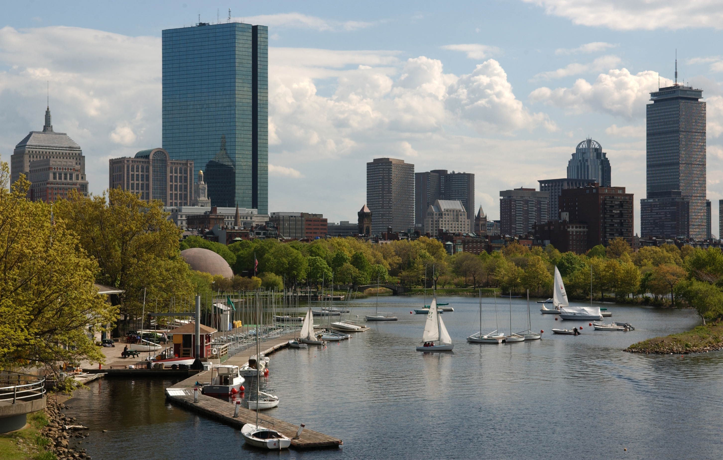
settlement_type = City
nickname = Beantown,cite web|url=http://www.boston.com/travel/boston/boston_nicknames/|publisher=The Boston Globe|title=What's in a nickname?|author=Norman Dalager|accessdate=2008-06-12] The Hub (of the Universe),1 The Cradle of Liberty, [cite web|url=http://www.britannia.com/travel/Market/boston-vacations.html|title=Boston Travel & Vacations|publisher=Britania|accessdate=2008-10-07] Title Town,cite web|url=http://www.philly.com/dailynews/sports/20080619__Title_Town__rolling_out_big_rally_to_honor_Celtics.html|publisher=Philly.com|title='Title Town' rolling out big rally to honor Celtics|accessdate=2008-06-21] The Cradle of Modern America, Athens of America, The Walking City
imagesize =
image_caption =
image_
mapsize = 250px
map_caption = Location in Suffolk County in Massachusetts, USA
mapsize1 =
map_caption1 =
subdivision_type = Country
subdivision_name = United States
subdivision_type1 = State
subdivision_name1 =Massachusetts
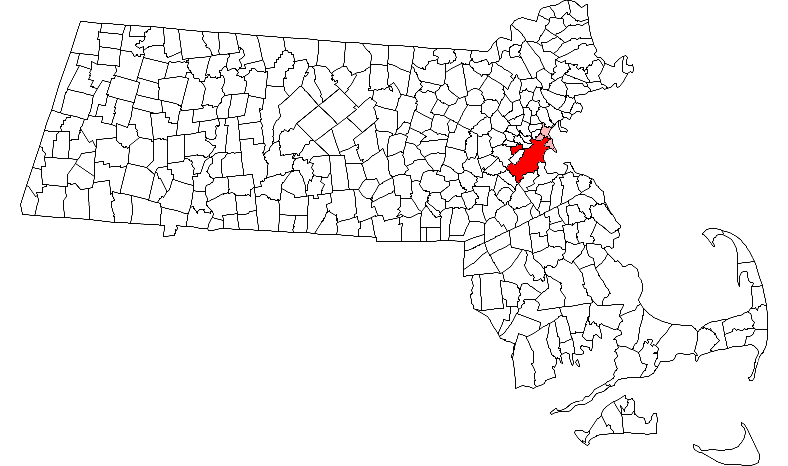
subdivision_type2 = County
subdivision_name2 = Suffolk
established_title = Settled
established_date = 1630
established_title2 = Incorporated (city)
established_date2 = 1822
government_type =
leader_title = Mayor
leader_name = Thomas M. Menino (D)
area_magnitude = 1 E8
unit_pref = Imperial
area_total_sq_mi = 89.6
area_total_km2 = 232.1
area_land_sq_mi = 48.4
area_land_km2 = 125.4
area_water_sq_mi = 41.2
area_water_km2 = 106.7
area_metro_km2 = 11684.7
area_metro_sq_mi = 4511.5
elevation_m = 43
elevation_ft = 141
population_as_of = 2006
population_metro = 5,977,504 [http://www.fairus.org/site/PageServer?pagename=research_researchfad0_sup#cps]Boston (pronounced Audio-IPA|en-us-Boston.ogg|/ˈbɒstən/) is the capital and largest city of the
Commonwealth ofMassachusetts . The city is located in Suffolk County, Massachusetts, in the northeasternUnited States . [cite web | url=http://www.city-data.com/city/Massachusetts.html | title=Massachusetts Bigger Cities (over 6000 residents) | year=2007 | publisher=City-Data.com | accessdate=2007-04-28] The largest city inNew England , Boston is considered the economic and cultural center of the entire region. [cite book | title=50 one day adventures in Massachusetts, Rhode Island, Connecticut, Vermont, New Hampshire, and Maine | author=Steinbicker, Earl | year=2000 | publisher=Hastingshouse/DaytripsPublishers | id=ISBN 0803820089 | pages=7] The city, which had an estimated population of 599,351 in 2007, lies at the center of the nowrap|Cambridge–Boston-Quincy metropolitan area—the 10th-largest metropolitan area (5th largest CSA) in the U.S., with a population of 4.5 million.In 1630,
Puritan colonists from England founded the city on theShawmut Peninsula .cite web | last=Banner | first=David | title=BOSTON HISTORY—The History of Boston, Massachusetts | url=http://www.searchboston.com/history.html | publisher=SearchBoston.com | year=2007 | accessdate=2007-04-28] During the late eighteenth century Boston was the location of several major events during theAmerican Revolution , including theBoston Massacre and theBoston Tea Party . Several early battles of the American Revolution, such as theBattle of Bunker Hill and theSiege of Boston , occurred within the city and surrounding areas. After American independence was attained Boston became a major shipping port and manufacturing center, and its rich history now attracts 16.3 million visitors annually.cite web| url=http://www.city-data.com/us-cities/The-Northeast/Boston-Economy.html | title=Boston: Economy | year=2006 | publisher=Thomson Gale (Thomson Corporation) | accessdate=2007-04-28] The city was the site of several firsts, including America's first public school,Boston Latin School (1635),cite web | url=http://www.boston.k12.ma.us/bps/bpsglance.asp#students | title=BPS at a Glance | publisher=Boston Public Schools | date=2007-03-14 | accessdate=2007-04-28] and first college,Harvard College (1636), in neighboring Cambridge. Boston was also home to the first subway system in the United States.cite book | title=The Rough Guide to Boston | last=Fagundes | first=David | coauthors=Grant, Anthony | publisher=Rough Guides | date=April 28, 2003 | id=ISBN 1-84353-044-9 ]Through
land reclamation and municipal annexation, Boston has expanded beyond the peninsula. With many colleges and universities within the city and surrounding area, Boston is a center of higher educationcite web | url=http://www.searchboston.com/guide.html | title=Visitors Guide to Boston | publisher=SearchBoston.com | year=2007 | accessdate=2007-02-19] and a center for medicine. The city's economy is also based on research, finance, and technology – principallybiotechnology . Boston has been experiencinggentrification and has one of the highest costs of living in the United States, though remains high on world livability rankings.cite web | author=Heudorfer, Bonnie; Bluestone, Barry | year=2004 | url=http://www.tbf.org/uploadedFiles/Housing%20Report%20Card%202004.pdf | format = pdf | title=The Greater Boston Housing Report Card | publisher=Center for Urban and Regional Policy (CURP), Northeastern University | pages=6 | accessdate=2007-02-19]History
Boston was founded on September 17, 1630 by
Puritan colonists from England. The Puritans of theMassachusetts Bay Colony are sometimes confused with thePilgrims who foundedPlymouth Colony ten years earlier in what is today Bristol County, Plymouth County, andBarnstable County, Massachusetts . The two groups are historically distinct and differed in religious practice. The separate colonies were not united until the formation of theProvince of Massachusetts Bay in 1691.The Shawmut peninsula was connected to the mainland by a narrow
isthmus , and surrounded by the waters ofMassachusetts Bay and the Back Bay, anestuary of theCharles River . Several prehistoric Native American archaeological sites excavated in the city have shown that the peninsula was inhabited as early as 5,000 BC. [cite web | url=http://www.sec.state.ma.us/mhc/mhcexh/exhidx.htm | title=Archaeology of the Central Artery Project: Highway to the Past | publisher=Commonwealth Museum—Massachusetts Historical Commission | year=2007 | accessdate=2007-04-06] Boston's early European settlers first called the area "Trimountaine", but later renamed the town afterBoston, Lincolnshire , England, from which several prominent colonists had emigrated.Massachusetts Bay Colony 's original governor,John Winthrop , gave a famous sermon entitled "A Model of Christian Charity," popularly known as the "City on a Hill" sermon, which captured the idea that Boston had a special covenant with God. (Winthrop also led the signing of theCambridge Agreement , which is regarded as a key founding document of the city.) Puritan ethics molded a stable and well-structured society in Boston. For example, shortly after Boston's settlement, Puritans founded America's first public school,Boston Latin School (1635), and America's first college,Harvard College (1636). Boston was the largest town in British North America until the mid-1700s. [cite web | url=http://www.bostonhistorycollaborative.org/pdf/Era2.pdf | title="Growth" to Boston in its Heyday, 1640’s to 1730’s | format=PDF | publisher=Boston History & Innovation Collaborative | year=2006 | accessdate=2007-05-08]In the 1770s, British attempts to exert more stringent control on the thirteen colonies, primarily via taxation, prompted Bostonians to initiate the
American Revolution . TheBoston Massacre , theBoston Tea Party , and several early battles occurred in or near the city, including theBattle of Lexington and Concord ,Battle of Bunker Hill , and theSiege of Boston . During this period,Paul Revere made his famous midnight ride.[

Dorchester Heights , 1841.] After the Revolution, Boston had become one of the world's wealthiest international trading ports due to the city's consolidated seafaring tradition – exports included rum, fish, salt, and tobacco. During this era, descendants of old Boston families became regarded as the nation's social and cultural elites; they were later dubbed the "Boston Brahmins ". In 1822, Boston was chartered as a city. [cite web | url=http://www.cityofboston.gov/visitors/about.asp | title=About Boston | publisher=City of Boston | year=2006 | accessdate=2007-05-08]The
Embargo Act of 1807 , adopted during theNapoleonic Wars , and theWar of 1812 significantly curtailed Boston's harbor activity. Although foreign trade returned after these hostilities, Boston's merchants had found alternatives for their capital investments in the interim. Manufacturing became an important component of the city's economy and by the mid-1800s, the city's industrial manufacturing overtook international trade in economic importance. Until the early 1900s, Boston remained one of the nation's largest manufacturing centers, and was notable for its garment production andleather goods industries. A network of small rivers bordering the city and connecting it to the surrounding region made for easy shipment of goods and allowed for a proliferation of mills and factories. Later, a dense network of railroads facilitated the region's industry and commerce. From the mid- to late nineteenth century, Boston flourished culturally; it became renowned for its rarefied literary culture and lavish artistic patronage. It also became a center of the abolitionist movement. [cite web | url=http://www.nps.gov/boaf/ | title=Boston African American National Historic Site | date=April 28, 2007 | publisher=National Park Service | accessdate=2007-05-08] The city reacted strongly to theFugitive Slave Law , which contributed to PresidentFranklin Pierce 's attempt to make an example of Boston after theBurns Fugitive Slave Case .In the 1820s, Boston's population began to swell and the city's ethnic composition changed dramatically with the first wave of European immigrants. Irish immigrants dominated the first wave of newcomers during this period. By 1850, about 35,000 Irish lived in Boston. [cite web | url=http://www.pbs.org/wgbh/amex/murder/peopleevents/p_immigrants.html | title=People & Events: Boston's Immigrant Population | year=2003 | publisher=WGBH/PBS Online (American Experience) | accessdate=2007-05-04] In the latter half of the nineteenth century, the city saw increasing numbers of Irish, Germans, Lebanese,
French Canadian s, and Russian and Polish Jews settle in the city. By the end of the nineteenth century, Boston's core neighborhoods had become enclaves of ethnically distinct immigrants – Italians inhabited the North End, the Irish dominatedSouth Boston , and Russian Jews lived in the West End.Irish and Italian immigrants brought with them
Roman Catholicism . Currently, Catholics make up Boston's largest religious community [cite web | url=http://www.city-data.com/world-cities/Boston-People.html | title=Boston People | year=2007 | publisher=city-data.com | accessdate=2007-05-05] and since the early twentieth century the Irish have played a major role in Boston politics—prominent figures include the Kennedys,Tip O'Neill , andJohn F. Fitzgerald .Between 1630 and 1890, the city tripled its physical size by
land reclamation , by filling in marshes, mud flats, and gaps between wharves along the waterfront, [cite web | url=http://www.iboston.org/rg/backbayImap.htm | title=The History of Land Fill in Boston | publisher=iBoston.org | year=2006 | accessdate=2006-01-09. Also see cite web | author=Howe, Jeffery | year=1996 | url=http://www.bc.edu/bc_org/avp/cas/fnart/fa267/bos_fill2.html | title=Boston: History of the Landfills | publisher=Boston College | accessdate=2007-04-30] a processWalter Muir Whitehill called "cutting down the hills to fill the coves." The largest reclamation efforts took place during the 1800s. Beginning in 1807, the crown of Beacon Hill was used to fill in a 50-acre (20 ha) mill pond that later became Haymarket Square. The present-day State House sits atop this shortened Beacon Hill. Reclamation projects in the middle of the century created significant parts of the South End, West End, the Financial District and Chinatown. After The Great Boston Fire of 1872, workers used building rubble as landfill along the downtown waterfront. During the mid-to-late nineteenth century, workers filled almost 600 acres (2.4 km²) of brackish Charles River marshlands west of the Boston Common with gravel brought by rail from the hills of Needham Heights. In addition, the city annexed the adjacent towns of Roxbury (1868), Dorchester (1870), Brighton, West Roxbury (including present day Jamaica Plain, Roslindale and West Roxbury), and Charlestown. The last three towns were annexed in 1874. [cite book | title=Historical Atlas of Massachusetts | pages=37 | year=1991 | publisher=University of Massachusetts]The first community health center in the United States was the Columbia Point Health Center in the Dorchester neighborhood of Boston. It was opened in December 1965 and served mostly the massive Columbia Point public housing complex adjoining it. It was founded by two medical doctors, Jack Geiger of Harvard University and Count Gibson of Tufts University. It is still in operation and was re-dedicated in 1990 as the Geiger-Gibson Community Health Center. [ Roessner, Jane. "A Decent Place to Live: from Columbia Point to Harbor Point - A Community History", Boston: Northeastern University Press, c2000. Cf. p.80, "The Columbia Point Health Center: The First Community Health Center in the Country".]
By the early and mid-twentieth century, the city was in decline as factories became old and obsolete, and businesses moved out of the region for cheaper labor elsewhere. Boston responded by initiating various
urban renewal projects under the direction of theBoston Redevelopment Authority (BRA), which was established in 1957. In 1958, BRA initiated a project to improve the historic West End neighborhood. Extensive demolition garnered vociferous public opposition to the new agency. [cite web | author=Collins, Monica | url=http://www.boston.com/news/globe/magazine/articles/2005/08/07/born_again/ | title=Born Again | publisher=The Boston Globe | date=August 7, 2005 | accessdate=2007-05-08] BRA subsequently reevaluated its approach to urban renewal in its future projects, including the construction of Government Center. By the 1970s, the city's economy boomed after thirty years of economic downturn. Hospitals such asMassachusetts General Hospital ,Beth Israel Deaconess Medical Center , andBrigham and Women's Hospital led the nation in medical innovation and patient care. Schools such asHarvard University , MIT,Boston University ,Boston College andNortheastern University attracted students to the Boston area. Nevertheless, the city experienced conflict starting in 1974 overdesegregation busing , which resulted in unrest and violence around public schools throughout the mid-1970s.The Columbia Point housing projects, built in 1953 on the Dorchester peninsula, had gone through bad times until there were only 350 families living in it in 1988. It was run down and dangerous. In 1984, the city of Boston gave control of it to a private developer, Corcoran-Mullins-Jennison, who re-developed and revitalized the property into an attractive residential mixed-income community called Harbor Point Apartments which was opened in 1988 and completed by 1990. It is a very significant example of revitalization and re-development and was the first federal housing project to be converted to private, mixed-income housing in the United States.
In the early twenty-first century the city has become an intellectual, technological, and political center. It has, however, experienced a loss of regional institutions, [cite web | url=http://www.boston.com/news/local/articles/2005/04/15/atlantic_148_year_institution_leaving_city/ | title=Atlantic, 148-year institution, leaving city | author=Feeney, Mark; Mehegan, David |date=April 15, 2005 | publisher=The Boston Globe | accessdate=2007-03-31] which included the acquisition of the "
Boston Globe " by "The New York Times ", and the loss to mergers and acquisitions of local financial institutions suchFleetBoston Financial , which was acquired by Charlotte-basedBank of America in 2004. The city also had to tacklegentrification issues and rising living expenses, with housing prices increasing sharply since the 1990s.Geography
Owing to its early founding, Boston is very compact. According to the
United States Census Bureau , the city has a total area of 89.6 square miles (232.1 km²)—48.4 square miles (125.4 km²) of it is land and 41.2 square miles (106.7 km²) (46.0%) of it is water. Boston is the fourth most densely populated city in the country not a part of a larger city'smetropolitan area . [After New York City, San Francisco, and Chicago. Many cities are denser but part of a larger city's metropolitan area such asPaterson, New Jersey .] Of United States cities over 500,000 in population, onlySan Francisco is smaller in land area. Boston's official elevation, as measured atLogan International Airport , is 19 feet (5.8 m) above sea level. [cite web | title=Elevation data—Boston | url=Gnis3|617565 | year=2007 |publisher=U.S. Geological Survey | accessdate=2007-02-19] The highest point in Boston is Bellevue Hill at 330 feet (101 m) above sea level, while the lowest point is at sea level. [cite web| url=http://www.peakbagger.com/peak.aspx?pid=6759|title=Bellevue Hill, Massachusetts | publisher=Peakbagger.com | year=2007 | accessdate=2007-03-21]Boston is surrounded by the "
Greater Boston " region, and bordered by the cities and towns of Winthrop, Revere, Chelsea, Everett, Somerville, Cambridge, Watertown, Newton, Brookline, Needham, Dedham, Canton, Milton, and Quincy.Much of the Back Bay and South End neighborhoods are built on reclaimed land—all of the earth from two of Boston's three original hills, the "trimount", was used as landfill material. Only Beacon Hill, the smallest of the three original hills, remains partially intact; just half of its height was cut down for landfill. The downtown area and immediate surroundings consist mostly of low-rise brick or stone buildings, with many older buildings in the Federal style. Several of these buildings mix in with modern high-rises, notably in the Financial District, Government Center, the South Boston waterfront, and Back Bay, which includes many prominent landmarks such as the
Boston Public Library , Christian Science Center,Copley Square ,Newbury Street , and New England's two tallest buildings: theJohn Hancock Tower and the Prudential Center. [cite web | url=http://www.emporis.com/en/wm/ci/?id=101045 | title=Boston Skyscrapers | publisher=Emporis.com | year=2005 |accessdate=2005-05-15] Near the John Hancock Tower is the old John Hancock Building with its prominent weather forecast beacon—whatever light illuminates gives an indication of weather to come: "steady blue. clear view; flashing blue, clouds are due; steady red, rain ahead; flashing red, snow instead." (In the summer, flashing red indicates instead that aRed Sox game has been rained out.) Smaller commercial areas are interspersed among single-family homes and wooden/brick multi-family row houses. Currently, the South End Historic District remains the largest surviving contiguous Victorian-era neighborhood in the U.S. [cite web | url=http://www.southendhistoricalsociety.org/about.htm | title=About the SEHS |publisher=South End Historical Society | year=2007 |accessdate=2007-02-19]Along with downtown, the geography of South Boston was particularly impacted by the Central Artery/Tunnel (CA/T) Project (or the "Big Dig"). The unstable reclaimed land in South Boston posed special problems for the project's tunnels. In the downtown area, the CA/T Project allowed for the removal of the unsightly elevated
Central Artery and the incorporation of new green spaces and open areas.Boston Common, located near the Financial District and Beacon Hill, is the oldest public park in the U.S. [cite web | url=http://www.celebrateboston.com/sites/bostoncommon.htm | title=Boston Common | year=2006 | publisher=CelebrateBoston.com | accessdate=2007-02-19] Along with the adjacent
Boston Public Garden , it is part of theEmerald Necklace , a string of parks designed byFrederick Law Olmsted to encircle the city. Franklin Park, which is also part of theEmerald Necklace , is the city's largest park and houses a zoo. [cite web | url=http://www.cityofboston.gov/parks/emerald/Franklin_Park.asp | title=Franklin Park | year=2007 | publisher=City of Boston | accessdate=2007-04-28] Another major park is theEsplanade located along the banks of theCharles River . Other parks are scattered throughout the city, with the major parks and beaches located near Castle Island, in Charlestown and along the Dorchester, South Boston, and East Boston shorelines.The Charles River separates Boston proper from Cambridge, Watertown, and the neighborhood of Charlestown. To the east lies
Boston Harbor and theBoston Harbor Islands National Recreation Area . TheNeponset River forms the boundary between Boston's southern neighborhoods and the city of Quincy and the town of Milton. [http://www.massbike.org/bikeways/neponset/ ] TheMystic River separates Charlestown from Chelsea and Everett, while Chelsea Creek and Boston Harbor separate East Boston from Boston proper. [cite web | url=http://www.topozone.com/map.asp?lat=42.35833&lon=-71.06028 | title=Kings Chapel Burying Ground, USGS Boston South (MA) Topo Map | publisher=TopoZone | year=2006 | accessdate=2007-04-29]Climate
Boston has what may basically be described as something between a
humid continental climate and ahumid subtropical climate , such as is very common in New England. Summers are typically warm and humid, while winters are cold, windy and snowy. Prevailing wind patterns that blow offshore affect Boston, minimizing the influence of theAtlantic Ocean .Spring in Boston can be warm, with temperatures as high as the 90s when winds are offshore, though it is just as possible for a day in late May to remain in the lower 40s due to cool ocean waters. The hottest month is July, with an average high of 82 °F (28 °C) and average low of 66 °F (18 °C), with conditions usually humid. The coldest month is January, with an average high of 36 °F (2 °C) and an average low of 22 °F (-6 °C). [cite web | url=http://www.erh.noaa.gov/box/climate/bosnml.shtml | publisher=NWS Taunton, MA | year=2006 | title=Boston Daily Normals | accessdate=2006-04-19] Periods exceeding convert|90|°F|°C|abbr=on in summer and below convert|10|°F|°C|abbr=on in winter are not uncommon, but rarely prolonged. The record high temperature is 104 °F (40 °C), recorded July 4, 1911. The record low temperature is -18 °F (-28 °C), recorded on February 9, 1934. February in Boston has seen 70 °F (21 °C) only once in recorded history, on February 24, 1985. The maximum temperature recorded in March was 89 °F (31 °C), on March 31, 1998. [cite web | url=http://www.erh.noaa.gov/box/climate/bosrecords.html | publisher=NWS Taunton, MA | year=2006 | title=Boston Temperature Records | accessdate=2006-02-09]
The city averages about 42 in (108 cm) of precipitation a year, with 40.9 in (104 cm) of snowfall a year. [cite web | url=http://www.weatherbase.com/weather/weather.php3?s=090527&refer= | title=Historical Weather for Boston, Massachusetts, United States of America | publisher=Weatherbase | year=2008 | accessdate=2008-04-06] Snowfall increases dramatically as one goes inland away from the city and the warming influence of the ocean. [cite web | url=http://www.city-data.com/states/Massachusetts-Climate.html | title=Massachusetts—Climate | year=2005 | publisher=city-data.com (Thomson Gale) | accessdate=2007-04-29] Most snowfall occurs December through March, usually with little or no snow in April and November and rare snow events in May and October. [cite web | url=http://www.intellicast.com/Almanac/Northeast/May/ | title=May in the Northeast | year=2003 | publisher=Intellicast.com | accessdate=2007-04-29] [cite web | url=http://www.boston.com/news/weather/articles/2005/10/30/snowstorm_packs_october_surprise/ | author=Wangsness, Lisa | title=Snowstorm packs October surprise | date=October 30, 2005 | publisher=The Boston Globe | accessdate=2007-04-29]
Boston's coastal location on the
North Atlantic , though it moderates temperatures, also makes the city very prone toNor'easter weather systems that can produce much snow and rain. [cite web | url=http://www.cityofboston.gov/arts/film/weather.asp | title=Weather | year=2007 | publisher=City of Boston Film Bureau | accessdate=2007-04-29] Fog is prevalent, particularly in spring and early summer, and the occasional tropical storm orhurricane can threaten the region, especially in early autumn.
Infobox Weather
single_line= Yes
location = Boston, Massachusetts
Jan_Hi_°F = 36 |Jan_Hi_°C = 2
Feb_Hi_°F = 38 |Feb_Hi_°C = 3
Mar_Hi_°F = 45 |Mar_Hi_°C = 7
Apr_Hi_°F = 56 |Apr_Hi_°C = 13
May_Hi_°F = 67 |May_Hi_°C = 19
Jun_Hi_°F = 77 |Jun_Hi_°C = 25
Jul_Hi_°F = 82 |Jul_Hi_°C = 28
Aug_Hi_°F = 80 |Aug_Hi_°C = 27
Sep_Hi_°F = 73 |Sep_Hi_°C = 23
Oct_Hi_°F = 63 |Oct_Hi_°C = 17
Nov_Hi_°F = 52 |Nov_Hi_°C = 11
Dec_Hi_°F = 41 |Dec_Hi_°C = 5
Year_Hi_°F = 59 |Year_Hi_°C = 15
Jan_Lo_°F = 22 |Jan_Lo_°C = -6
Feb_Lo_°F = 23 |Feb_Lo_°C = -5
Mar_Lo_°F = 31 |Mar_Lo_°C = -1
Apr_Lo_°F = 40 |Apr_Lo_°C = 4
May_Lo_°F = 50 |May_Lo_°C = 10
Jun_Lo_°F = 59 |Jun_Lo_°C = 15
Jul_Lo_°F = 65 |Jul_Lo_°C = 18
Aug_Lo_°F = 64 |Aug_Lo_°C = 18
Sep_Lo_°F = 57 |Sep_Lo_°C = 14
Oct_Lo_°F = 47 |Oct_Lo_°C = 8
Nov_Lo_°F = 38 |Nov_Lo_°C = 3
Dec_Lo_°F = 27 |Dec_Lo_°C = -3
Year_Lo_°F = 44 |Year_Lo_°C = 7
Jan_Precip_inch = 3.8 |Jan_Precip_cm =|Jan_Precip_mm =97
Feb_Precip_inch = 3.5 |Feb_Precip_cm =|Feb_Precip_mm =89
Mar_Precip_inch = 4.0 |Mar_Precip_cm =|Mar_Precip_mm =102
Apr_Precip_inch = 3.7 |Apr_Precip_cm =|Apr_Precip_mm =94
May_Precip_inch = 3.4 |May_Precip_cm =|May_Precip_mm =86
Jun_Precip_inch = 3.0 |Jun_Precip_cm =|Jun_Precip_mm =76
Jul_Precip_inch = 2.8 |Jul_Precip_cm =|Jul_Precip_mm =71
Aug_Precip_inch = 3.6 |Aug_Precip_cm =|Aug_Precip_mm =91
Sep_Precip_inch = 3.3 |Sep_Precip_cm =|Sep_Precip_mm =84
Oct_Precip_inch = 3.3 |Oct_Precip_cm =|Oct_Precip_mm =84
Nov_Precip_inch = 4.4 |Nov_Precip_cm =|Nov_Precip_mm =112
Dec_Precip_inch = 4.2 |Dec_Precip_cm =|Dec_Precip_mm =107
Year_Precip_inch = 42.9 |Year_Precip_cm =|Year_Precip_mm =1090
Jan_Snow_inch=12.0
Feb_Snow_inch=11.3
Mar_Snow_inch=7.9
Apr_Snow_inch=0.9
May_Snow_inch=0.0
Jun_Snow_inch=0.0
Jul_Snow_inch=0.0
Aug_Snow_inch=0.0
Sep_Snow_inch=0.0
Oct_Snow_inch=0.0
Nov_Snow_inch=1.3
Dec_Snow_inch=7.5
Year_Snow_inch=40.9
source =Weatherbasecite web
url =http://www.weatherbase.com/weather/weather.php3?s=090527&refer= |title =Weatherbase: Historical Weather for Boston, Massachusetts, United States of America | publisher=Weatherbase | year=2008 | accessdate=2008-09-24]
accessdate = Sep 2008Demographics
USCensusPop
1790= 18320
1800= 24937
1810= 33787
1820= 43298
1830= 61392
1840= 93383
1850= 136881
1860= 177840
1870= 250526
1880= 362839
1890= 448477
1900= 560892
1910= 670585
1920= 748060
1930= 781188
1940= 770816
1950= 801444
1960= 697197
1970= 641071
1980= 562994
1990= 574283
2000= 589141
estyear=2007
estimate=599351According to the censusGR|2 of 2000, there were 589,141 people, (the population estimate of 2006 was 596,638 people), [cite web | url=http://www.census.gov/popest/archives/2000s/vintage_2005/05s_challenges.html | title=2005 challenges | date=February 16, 2007 | publisher=United States Census Bureau | accessdate=2007-04-28] 239,528 households, and 115,212 families residing in the city. The
population density was 12,166 people per square mile (4,697/km²). Of major US cities, [Includes only cities larger than 250,000] onlyNew York City , San Francisco, andChicago have a greater population density than Boston. [cite web|url=http://www.demographia.com/db-us90city100kdens.htm|title=US Cities Over 100,000:Ranked by Population Density: 1990|publisher=Wendell Cox Consultancy|accessdate=2007-10-01] There were 251,935 housing units at an average density of 5,203 per square mile (2,009/km²).However, the population of Boston can grow during the daytime to about 1.2 million. This fluctuation of people is caused by suburban residents traveling to the city for work, education, medical purposes, and special events. [cite web | url=http://www.cityofboston.gov/bra/PDF/ResearchPublications//pdr96-1.pdf |format = pdf | title=Boston's Population Doubles—Every Day | publisher=Boston Redevelopment Authority—Insight Reports | month=December | year=1996 | accessdate=2007-02-24 ]
According to the 2000 census, the racial makeup of the city was 49% Non-Hispanic White, 25%
African American or Black, 8%Asian American , 1% Native American, 4% from other races, and 3% from two or more races. 14% of the population was Hispanic or Latino who can be of any race.According to a 2006 estimate, the White population comprises 53.5% of the population, while Hispanics make up 15.5%. [cite web | url=http://www.bestplaces.net/city/Boston_MA-PEOPLE-52507000010.aspx | title=Boston, Massachusetts | publisher=Sperling's BestPlaces | year=2008 | accessdate=2008-04-06] People of Irish descent form the largest single ethnic group in the city, making up 15.8% of the population, followed by
Italians , accounting for 8.3% of the population. People ofWest Indian ancestry are another sizeable group, at 6.4%,cite web | url=http://factfinder.census.gov/servlet/QTTable?_bm=y&-context=qt&-qr_name=DEC_2000_SF3_U_DP2&-ds_name=DEC_2000_SF3_U&-CONTEXT=qt&-tree_id=402&-redoLog=true&-all_geo_types=N&-geo_id=16000US2507000&-search_results=01000US&-_sse=on&-format=&-_lang=en| title=Boston city, Massachusetts—DP-2, Profile of Selected Social Characteristics: 2000 | year=2000 | publisher=United States Census Bureau | accessdate=2007-05-04] about half of whom are ofHaiti an ancestry. Some neighborhoods, such as Dorchester, have received an influx of Vietnamese residents in recent decades. Neighborhoods such as Jamaica Plain and Roslindale have experienced a growing number ofDominican Americans .There were 239,528 households, out of which 22.7% had children under the age of 18 living in them, 27.4% were married couples living together, 16.4% had a female householder with no husband present, and 51.9% were non-families. 37.1% of all households were made up of individuals and 9.1% had someone living alone who was 65 years of age or older. The average household size was 2.31 and the average family size was 3.17.cite web | url=http://factfinder.census.gov/servlet/QTTable?_bm=y&-geo_id=16000US2507000&-qr_name=DEC_2000_SF1_U_DP1&-ds_name=DEC_2000_SF1_U&-_lang=en&-redoLog=false&-_sse=on| title=Boston city, Massachusetts—DP-1, Profile of General Demographics Characteristics: 2000 | year=2000 | publisher=United States Census Bureau | accessdate=2007-05-04]
In the city the population was spread out with 19.8% under the age of 18, 16.2% from 18 to 24, 35.8% from 25 to 44, 17.8% from 45 to 64, and 10.4% who were 65 years of age or older. The median age was 31 years. For every 100 females, there were 92.8 males. For every 100 females age 18 and over, there were 90.2 males.
The
median income for a household in the city was $39,629, and the median income for a family was $44,151. Males had a median income of $37,435 versus $32,421 for females. Theper capita income for the city was $23,353. 19.5% of the population and 15.3% of families are below thepoverty line . Out of the total population, 25.6% of those under the age of 18 and 18.2% of those 65 and older were living below the poverty line.cite web | url=http://factfinder.census.gov/servlet/QTTable?_bm=y&-geo_id=16000US2507000&-qr_name=DEC_2000_SF3_U_DP3&-ds_name=DEC_2000_SF3_U&-_lang=en&-redoLog=false&-_sse=on | title=Boston city, Massachusetts—DP-3. Profile of Selected Economic Characteristics: 2000 | year=2000 | publisher=United States Census Bureau | accessdate=2007-05-04]Crime
The city has seen a great reduction in violent
crime since the early 1990s. Boston's low crime rate in the last years of the twentieth century and the beginning of the twenty-first has been credited to its police department's collaboration with neighborhood groups and church parishes to prevent youths from joining gangs, as well as involvement from theUnited States Attorney andDistrict Attorney 's offices. This helped lead in part to what has been touted as the "Boston Miracle." Murders in the city dropped from 152 in 1990 (for a murder rate of 26.5 per 100,000 people) to just 31—not one of them a juvenile—in 1999 (for a murder rate of 5.26 per 100,000). In more recent years, however, the annual murder count has fluctuated by as much as 50% compared to the year before, with 60 murders in 2002, followed by just 39 in 2003, 64 in 2004, and 75 in 2005. Though the figures are nowhere near the high-water mark set in 1990, the aberrations in the murder rate have been unsettling for many Bostonians and have prompted discussion over whether the Boston Police Department should reevaluate its approach to fighting crime. [cite web | author=Winship, Christopher | month=March | year=2002 | url=http://www.wjh.harvard.edu/soc/faculty/winship/End_of_a_Miracle.pdf | format = pdf | title=End of a Miracle? | publisher=Harvard University | accessdate=2007-02-19] [cite web | url=http://www.cityofboston.gov/police/ore.asp | title=Boston Police Department's Monthly Crime Statistics | year=2005 | publisher=CityOfBoston.gov | accessdate=2007-02-19] [cite web | url=http://boston.areaconnect.com/crime1.htm | title=Boston MA Crime Statistics (2004—New Crime Data) | year=2007 | publisher=areaConnect.com | accessdate=2007-02-19]Economy
:"See also: Major companies in Greater Boston"Boston's colleges and universities have a major impact on the city and region's economy. Not only are they major employers, but they also attract high-tech industries to the city and surrounding region. Boston is home to
technology companies such asEMC Corp. andAnalog Devices as well asE-Commerce companiesVistaPrint andCSN Stores . Boston is also a major hub forbiotechnology companies, includingMillennium Pharmaceuticals ,Merck & Co. ,Millipore ,Genzyme , andBiogen Idec . According to a 2003 report by the Boston Redevelopment Authority, students enrolled in Boston's colleges and universities contribute $4.8 billion annually to the city's economy. [cite web | url=http://www.cityofboston.gov/bra/PDF/ResearchPublications//pdr97-2.pdf | format=pdf | title= Leadership Through Innovation: The History of Boston's Economy | year=2003 | publisher=Boston Redevelopment Authority | accessdate=2007-04-18] Boston also receives the highest amount of annual funding from theNational Institutes of Health of all cities in the United States. [cite web | url=http://www.ssti.org/Digest/Tables/022006t.htm | title=Top 100 NIH Cities | year=2004 | publisher=SSTI.org | accessdate=2007-02-19]Tourism comprises a large part of Boston's economy. In 2004 tourists spent $7.9 billion and made the city one of the ten most popular tourist locations in the country. Other important industries include
financial services , especiallymutual fund s andinsurance . Boston-basedFidelity Investments helped popularize the mutual fund in the 1980s, and has made Boston one of the top financial cities in the United States. The city is also the regional headquarters of major banks such asBank of America andSovereign Bank , and a center forventure capital .State Street Corporation , which specializes in asset management and custody services, is headquartered in the city. Boston is also a printing and publishing center –Houghton Mifflin is headquartered within the city, along with Bedford-St. Martin's Press,Beacon Press , andLittle, Brown and Company .Pearson PLC publishing units also employ several hundred people in Boston. The city is home to four majorconvention center s: theHynes Convention Center in the Back Bay, the Bayside Expo Center in Dorchester, and the World Trade Center Boston andBoston Convention and Exhibition Center on the South Boston waterfront. Because of its status as a state capital and the regional home of federal agencies, law and government is another major component of the city's economy.Major companies headquartered within the city include the
Liberty Mutual insurance company, Gillette (now owned byProcter & Gamble ), andTeradyne , one of the world's leading manufacturers of semiconductor and other electronic test equipment.New Balance has its headquarters in the city. Boston is also home tomanagement consulting firmsThe Boston Consulting Group ,Monitor Group , andBain & Company , as well as the private equity group Bain Capital. [cite web | url=http://www.bcg.com/this_is_bcg/bcg_history/bcg_history_1963.html | title=This is BCG—History—1963 | publisher=The Boston Consulting Group | year=2007 | accessdate=2007-06-22] Other major companies are located outside the city, especially along Route 128. [cite web | url=http://www.city-data.com/world-cities/Boston-Economy.html | title=Cities of the World—Boston Economy | publisher=city-data.com | year=2007 | accessdate=2007-04-28] ThePort of Boston is a major seaport along the United States' East Coast, and is also the oldest continuously-operated industrial andfishing port in theWestern Hemisphere . [cite web | url=http://www.massport.com/ports/about_histo.html | title=About the Port—History | year=2007 | publisher=Massport | accessdate=2007-04-28] Boston is classified as a "Gamma world city" by a study group atLoughborough University in England.Culture
Boston shares many cultural roots with greater New England, including a dialect of the non-rhotic Eastern New England accent known as Boston English, and a regional cuisine with a large emphasis on seafood, rum, salt, and dairy products.
Irish Americans are a major influence on Boston's politics and religious institutions. Boston also has its own collection ofneologism s known as Boston slang.Many consider Boston to have a strong sense of cultural identity, perhaps as a result of its intellectual reputation; much of Boston's culture originates at its universities. [cite journal | author=Phelan, Joseph | month=November | year=2004 | title= [http://www.artcyclopedia.com/feature-2004-11.html Boston Marathon] | journal=Artcyclopedia] The city has several ornate theatres, including the
Cutler Majestic Theatre ,Boston Opera House ,Citi Performing Arts Center , and the Orpheum Theatre. Renowned performing-arts organizations include theBoston Symphony Orchestra ,Boston Ballet ,Boston Pops ,Celebrity Series of Boston ,Boston Early Music Festival , Boston Lyric Opera Company, OperaBoston,Emmanuel Music , and theHandel and Haydn Society (one of the oldest choral companies in the United States). [cite web | url=http://www.handelandhaydn.org/learn/whoweare/whoweare_home.htm | title=Who We Are | year=2007 | publisher=Handel and Haydn Society | accessdate=2007-04-28] There are also many major annual events such asFirst Night , which occurs onNew Year's Eve , the annualBoston Arts Festival at Chistopher Columbus Waterfront Park, Italian summer feasts in the North End honoring Catholic saints, and several events during the Fourth of July period. These events include the week-long Harborfest festivities [cite web | url=http://www.bostonharborfest.com/about/index.html | title=About Boston Harborfest! | publisher=Boston Harborfest | date= January 15, 2007 | accessdate=2007-03-31] and aBoston Pops concert accompanied by fireworks on the banks of theCharles River . [cite web | url=http://www.july4th.org/generaleventinfo/faqs/ | title=General Event Information—Frequently Asked Questions | publisher=Boston 4 Celebrations Foundation | year=2007 | accessdate=2007-04-29]Because of the city's prominent role in the
American Revolution , several historic sites relating to that period are preserved as part of theBoston National Historical Park . Many are found along theFreedom Trail , which is marked by a red line of bricks embedded in the ground. The city is also home to several prominent art museums, including the Museum of Fine Arts and theIsabella Stewart Gardner Museum . In December 2006, the Institute of Contemporary Art moved from its Back Bay location to a new contemporary building designed byDiller Scofidio + Renfro located in the Seaport District. TheUniversity of Massachusetts campus at Columbia Point houses theJohn F. Kennedy Library . TheBoston Athenaeum (one of the oldest independent libraries in the United States), [cite web | url=http://www.bostonathenaeum.org/general.html | title=General Information: Introduction and History | publisher=Boston Athenæum | year=2007 | accessdate=2007-04-28]Boston Children's Museum ,Bull & Finch Pub (whose building is known from the television show "Cheers "), Museum of Science, and theNew England Aquarium are within the city.Boston is also one of the birthplaces of the
hardcore punk genre of music. Boston musicians have contributed greatly to this music scene over the years ("see alsoBoston hardcore "). Boston neighborhoods were home to one of the leading localthird wave ska andska punk scenes in the 1990s, led by bands such asThe Mighty Mighty Bosstones ,The Allstonians , The Pixies, and theDropkick Murphys . The 1980s' hardcore punk-rock compilation "This Is Boston, Not L.A. " highlights some of the bands that built the genre. Several nightclubs, such as The Channel, Bunnratty's in Allston, andThe Rathskeller , were renowned for showcasing both local punk-rock bands and those from farther afield. All of these clubs are now closed. Many were razed during recent gentrification. [cite web | author=Wardrop, Josh B. | url=http://www.panoramamagazine.com/panoramamagazine/articles/boston_rocks.aspx | title=A look at the Hub’s place in rock ’n’ roll history | date= September 25, 2006 | publisher=Panorama Magazine | accessdate=2007-04-28]Media
"
The Boston Globe " (owned byThe New York Times Company ) and the "Boston Herald " are Boston's two major dailynewspaper s. The "Christian Science Monitor ", a third daily, is edited in Boston and printed in a series of regional presses across the U.S. The city is also served by other publications such as "The Boston Phoenix ", "Boston magazine ", "The Improper Bostonian ", "Boston's Weekly Dig ", and the Boston edition of "Metro". "The Boston Globe" also releases a teen publication to the city's public high schools. The newspaper "Teens in Print" or "T.i.P." is written by the city's teens and delivered quarterly within the school year. [cite web | url=http://www.cityofboston.gov/bra/writeboston/TIP.asp | title=WriteBoston – T.i.P | publisher=City of Boston | year=2007 | accessdate=2007-04-28]Boston has the largest broadcasting market in New England, with the Boston radio market being the eleventh largest in the United States. [cite web | url=http://www.arbitron.com/radio_stations/mm001050.asp | title=Arbitron - Market Ranks and Schedule, 1–50 | publisher=Arbitron | year=Fall 2005 | accessdate=2007-02-18] Several major AM stations include
talk radio WRKO 680 AM, sports/talk station WEEI 850 AM, and news radio WBZ 1030 AM. A variety of FMradio format s serve the area, as do NPR stationsWBUR and WGBH. College and university radio stations includeWERS (Emerson),WHRB (Harvard),WUMB (UMass Boston),WMBR (M.I.T.),WZBC (Boston College),WMFO (Tufts University),WBRS (Brandeis University),WTBU (Boston University, campus and web only),WRBB (Northeastern University) and WMLN (Curry College).The Boston television DMA, which also includes
Manchester, New Hampshire , is the seventh largest in the United States. [cite web | url=http://www.nielsenmedia.com/DMAs.html | title=DMA Listing | year=2006 | publisher=Nielsen Media | accessdate=2007-02-18] The city is served by stations representing every major American network including WBZ 4 (CBS ), WCVB 5 (ABC), WHDH 7 (NBC ), WFXT 25 (Fox), WUNI 27 (Univision ), and WLVI 56 (The CW). Boston is also home to PBS station WGBH 2, a major producer of PBS programs, which also operates WGBX 44. Most Boston television stations have their transmitters in nearby Needham and Newton. [cite web | url=http://www.bostonradio.org/route-128.html | title=The Route 128 tower complex | year=2007 | publisher=The Boston Radio Archives | accessdate=2007-04-28]ports
The
Boston Red Sox are a founding member of theAmerican League ofMajor League Baseball and are the2007 World Series champions. The team plays its home games atFenway Park , nearKenmore Square in the Fenway section. Built in 1912, it is the oldest sports arena or stadium in active use in the United States among the four major professional sports. Boston was also the site of the first game of the first modernWorld Series , in 1903. The series was played between the Red Sox and thePittsburgh Pirates . [cite web | url=http://mlb.mlb.com/NASApp/mlb/mlb/history/postseason/mlb_ws_recaps.jsp?feature=1903 | title=1903 World Series—Major League Baseball: World Series History | publisher=Major League Baseball at MLB.com | year=2007 | accessdate=2007-02-18] Persistent reports that the team was known in 1903 as the "Boston Pilgrims" appear to be unfounded. [cite web | url=http://www.baseball-almanac.com/articles/boston_pilgrims_story.shtml | title=The Boston Pilgrims Never Existed | author=Bill Nowlin | publisher=Baseball Almanac | year=2008 | accessdate=2008-04-03] TheBoston Braves were Boston's NL team (1871-1953) until they moved to Milwaukee in 1953, then later Atlanta in 1966 where they currently play as theAtlanta Braves .The
TD Banknorth Garden (formerly called the Fleet Center, and the Shawmut Center) is adjoined to North Station and is the home of two major league teams: theBoston Bruins ice hockey team of theNational Hockey League and the 2008National Basketball Association champions, theBoston Celtics . The stadium seats 18,624. The Bruins were the first American member of theNational Hockey League and anOriginal Six franchise. The Boston Celtics were founding members of theBasketball Association of America , one of the two leagues that merged to form the NBA. The Celtics have the distinction of having more national titles than any other NBA team with 17 championships from 1957 to 2008. [cite web | url=http://www.nba.com/history/finals/champions.html | title=NBA Finals: All-Time Champions | publisher=NBA | year=2007 | accessdate=2007-02-20]Although the team has played in suburban Foxboro since 1971, the
New England Patriots are Boston's football team. The team was founded in 1960 as the Boston Patriots, a charter member of theAmerican Football League , and in 1970 the team joined theNational Football League . The team has won threeSuper Bowl titles since the 2001 season (in 2001, 2003, and 2004). [cite web | url=http://www.patriots.com/history/index.cfm?ac=History | title=The History of the New England Patriots | publisher=New England Patriots | year=2007 | accessdate=2007-04-29] They shareGillette Stadium with theNew England Revolution ofMajor League Soccer . There has also been talk of a possibleArena Football League expansion team coming to Boston sometime in the next few years. [cite web | url=http://www.usatoday.com/sports/football/2007-02-28-arena-league-kickoff_x.htm | title=Arena Football League kicks off new season with business booming | publisher=USA Today | year=2007 | accessdate=2007-09-15]Boston's many colleges and universities are active in college athletics. There are four NCAA Division I members in the city:
Boston College (member of theAtlantic Coast Conference ),Boston University (America East Conference ), Northeastern University (Colonial Athletic Association ), andHarvard University (Ivy League ). All except Harvard, which belongs toECAC Hockey , belong to theHockey East conference. The hockey teams of these four universities meet every year in a four-team tournament known as the "Beanpot Tournament," which is played at the TD Banknorth Garden over two Monday nights in February. [cite web | author=Bertagna, Joe | url=http://www.beanpothockey.com/tradition.html | title=The Beanpot At 50 — Still Inspiring and Still Growing | date=December 27, 2001 | publisher=Beanpot Hockey | accessdate=2007-04-28]One of the most famous sporting events in the city is the
Boston Marathon , the 26.2 mile (42.2 km) run from Hopkinton to Copley Square in the Back Bay. The Marathon, the world's oldest, is popular and heavily attended. [cite web | url=http://www.bostonmarathon.org/BostonMarathon/RaceFacts.asp | title=B.A.A. Boston Marathon Race Facts | year=2007 | publisher=Boston Athletic Association | accessdate=2007-04-29] It is run onPatriots' Day in April and always coincides with a Red Sox home baseball game that starts at 11:05 AM (10:05 beginning in 2007), the only MLB game all year to start before noon local time. [cite web |url=http://www.redsoxconnection.com/patriotsday.html | title=Patriots’ Day and the Red Sox | year=2007 | publisher=Red Sox Connection | accessdate=2007-04-29] Another major event held in the city is theHead of the Charles Regatta rowing competition on the Charles River.Boston is also bidding for the
2020 Summer Olympics . [ [http://www.gamesbids.com/cgi-bin/news/viewnews.cgi?category=1&id=1194888323 Feasibility Studies For Boston 2020, Netherlands 2028 Summer Games] ]Government
Boston has a
strong mayor system in which themayor is vested with extensive executive powers. The mayor is elected to a four-year term by plurality voting. The city council is elected every two years. There are nine district seats, each elected by the residents of that district through plurality voting, and four at-large seats. Each voter casts up to four votes for at-large councilors, with no more than one vote per candidate. The candidates with the four highest vote totals are elected. The president of the city council is elected by the councilors from within themselves. The school committee for theBoston Public Schools is appointed by the mayor. [cite web | url=http://boston.k12.ma.us/bps/bpsglance.asp#leadership | title=The Boston Public Schools at a Glance: School Committee | publisher=Boston Public Schools | date= March 14, 2007 | accessdate=2007-04-28] TheBoston Redevelopment Authority and the Zoning Board of Appeals (a seven-person body appointed by the mayor) share responsibility for land-use planning. [cite web | url=http://www.cityofboston.gov/isd/building/boa/pdfs/Zoning_Booklet.pdf | title=A Guide to the City of Boston's Zoning Board of Appeal Process | publisher=City of Boston | month=October | year=2000 | accessdate=2007-11-14|format=PDF]In addition to city government, numerous commissions and state authorities play a role in the life of Bostonians, including the
Massachusetts Department of Conservation and Recreation , the Boston Public Health Commission, and the Massachusetts Port Authority (Massport). As the capital of Massachusetts, Boston plays a major role in state politics. The city has several properties relating to the United States federal government, including the John F. Kennedy Federal Office Building and the Thomas P. O'Neill Federal Building. [cite web | url=http://www.gsa.gov/Portal/gsa/ep/channelView.do?pageTypeId=8199&channelPage=%2Fep%2Fchannel%2FgsaOverview.jsp&channelId=-14339 | title=Massachusetts Federal Buildings | date= February 1, 2007 | publisher=United States General Services Administration | accessdate=2007-04-29] The city also serves as the home of theUnited States Court of Appeals for the First Circuit , theUnited States District Court for the District of Massachusetts , as well as the headquarters of theFederal Reserve Bank of Boston (the First District of theFederal Reserve ). The city is in the Eighth and NinthCongressional district s. [cite web | url=http://www.govtrack.us/congress/findyourreps.xpd?state=MA | title=Massachusetts's Representatives—Congressional District Maps | year=2007 | publisher=GovTrack.us | accessdate=2007-04-28]Education
Boston's reputation as the "Athens of America" derives in large part from the teaching and research activities of more than 100 colleges and universities located in the
Greater Boston Area, [cite web | url=http://www.bhcc.mass.edu/inside/54 | title=About Boston | year=2006 | publisher=Bunker Hill Community College | accessdate=2007-06-01] with more than 250,000 students attending college in Boston and Cambridge alone. Within the city,Boston University exudes a large presence as the city's fourth-largest employer, [Cite web| url=http://www.cityofboston.gov/bra/PDF/ResearchPublications/pdr509.pdf | title=Largest Employers in the City of Boston | publisher=Boston Redevelopment Authority | year=1996-1997 | accessdate=2007-06-01] and maintains a campus along the Charles River on Commonwealth Avenue and its medical campus in the South End. Northeastern University, another large private university, is located in the Fenway area, and is particularly known for its Business and Health Science schools and cooperative education program.Wheelock College , Massachusetts College of Art and Design, Simmons College,Emmanuel College ,Massachusetts College of Pharmacy and Health Sciences , andWentworth Institute of Technology , founding members of theColleges of the Fenway , are adjacent to Northeastern University.Suffolk University , a small private university known for its law school, maintains a campus on Beacon Hill.New England School of Law , a small private law school located in the theater district, was originally established as America's only all female law school. [cite web | url=http://www.nesl.edu/about/history.cfm | title=History of NESL | publisher=New England School of Law | year=2006 | accessdate=2007-03-21]Emerson College , a small private college with a strong reputation in the fields of performing arts, journalism, writing, and film, is located nearby on Boston Common.Boston College , whose original campus was located in South Boston, moved its campus west to a site that straddles the Boston(Brighton)-Newton border. Boston College is expanding further into the Brighton neighborhood following the purchase of adjacent land from the Boston Catholic Archdiocese. [cite web | author=Laczkoski, Michelle | url=http://media.www.dailyfreepress.com/media/storage/paper87/news/2006/02/27/News/Bc.Outlines.Move.Into.AllstonBrighton-1639148.shtml | title=BC outlines move into Allston-Brighton | date=February 27, 2006 | publisher=The Daily Free Press (Boston University) | accessdate=2007-04-28]Boston is also home to several conservatories and art schools, including the Art Institute of Boston,
Massachusetts College of Art , New England School of Art and Design (part of Suffolk University), and theNew England Conservatory of Music (the oldest independent conservatory in the United States). [cite web | url=http://www.newenglandconservatory.edu/reports_factsheets/briefhistory.html | title=A Brief History of New England Conservatory | year=2007 | publisher=New England Conservatory of Music | accessdate=2007-04-28] Other conservatories include theBoston Conservatory , the School of the Museum of Fine Arts andBerklee College of Music . Boston has one major public university, theUniversity of Massachusetts Boston , located on Columbia Point in Dorchester, while Roxbury Community College andBunker Hill Community College are the city's two community colleges.Several major national universities located outside Boston have a major presence in the city.
Harvard University , the nation's oldest, and arguably best known, institution of higher learning, is located across the Charles River in Cambridge. The business and medical schools are in Boston, and there are plans for additional expansion into Boston's Allston neighborhood. [cite web | author=Kladko, Brian | url=http://boston.bizjournals.com/boston/stories/2007/04/23/story2.html?i=79430&b=1177300800%5E1449823 | title=Crimson Tide | date=April 20, 2007 | publisher=Boston Business Journal | accessdate=2007-04-28] TheMassachusetts Institute of Technology (MIT), which originated in Boston and was long known as "Boston Tech," moved across the river to Cambridge in 1916.Tufts University administers its medical and dental school adjacent to theTufts Medical Center , a 451-bed academic medical institution that is home to both a full-service hospital for adults and the Floating Hospital for Children.Eastern Nazarene College in Quincy, is the only evangelical Christian college in metropolitan Boston and is active in Christian ministry in the City of Boston. [cite web | url=http://www.enc.edu/downloads/viewbook2006.pdf | title=The 2006 ENC Viewbook (p. 61) | format=PDF | publisher=Eastern Nazarene College | year=2006 | accessdate=2007-06-01]Boston Public Schools , the oldest public school system in the U.S., enrolls 57,000 students fromkindergarten to grade 12. The system operates 145 schools, which includesBoston Latin School (the oldest public school in the United States, established in 1635; which, along withBoston Latin Academy , is a highly prestigious public exam school admitting students in the 7th and 9th grades only and serving grades 7–12),English High (the oldest publichigh school , established 1821), andthe Mather School (the oldest public elementary school, established in 1639). The city also has private, parochial, andcharter school s. 3000 students of racial minorities attend participating suburban schools through the Metropolitan Educational Opportunity Council, orMETCO . In 2002, "Forbes Magazine " ranked the Boston Public Schools as the best large city school system in the country, with a graduation rate of 82%. [cite journal | title= [http://www.forbes.com/2004/02/13/cx_bs_0213home.html The Best Education in the Biggest Cities] | year=2002 | journal=Forbes] In 2005, the student population within the school system was 45.5% Black or African American, 31.2% Hispanic or Latino, 14% White, and 9% Asian, as compared with 24%, 14%, 49%, and 8% respectively for the city as a whole. [cite web | url=http://www.boston.com/news/education/k_12/articles/2005/11/03/Boston_public_schools/ | title = Boston public schools | publisher=Boston Globe | date=2005-11-03 | accessdate=2007-09-29] [cite web | url=http://www.unausa.org/site/pp.asp?c=fvKRI8MPJpF&b=364181 |title=About Boston Public Schools|publisher=United Nations Association of the United States of America|accessdate=2007-10-30]Healthcare and utilities
:"See also: List of hospitals in Boston" The
Longwood Medical Area is a region of Boston with a concentration of medical and research facilities, includingBeth Israel Deaconess Medical Center ,Brigham and Women's Hospital ,Children's Hospital Boston ,Dana-Farber Cancer Institute ,Harvard Medical School ,Harvard School of Public Health andHarvard School of Dental Medicine . [cite web | url=http://www.masco.org/index2.htm | title=Overview | publisher=MASCO—Medical Academic and Scientific Community Organization | year=2007 | accessdate=2007-02-21]Massachusetts General Hospital (MGH) is near the Beacon Hill neighborhood, with theMassachusetts Eye and Ear Infirmary andSpaulding Rehabilitation Hospital nearby. Boston also has VA medical centers in the Jamaica Plain and West Roxbury neighborhoods. [cite web | url=http://www1.va.gov/directory/guide/rpt_fac_list.cfm?isflash=0 | title=Facility Listing Report | year=2007 | publisher=United States Department of Veterans Affairs | accessdate=2007-04-28]Many of Boston's major medical facilities are associated with universities. The facilities in the Longwood Medical Area and MGH are world-renownedFact|date=August 2008 research medical centers affiliated with Harvard Medical School.
Tufts Medical Center (formerly Tufts-New England Medical Center), located in the southern portion of the Chinatown neighborhood, is affiliated withTufts University School of Medicine .Boston Medical Center , located in the South End neighborhood, is the primary teaching facility for theBoston University School of Medicine as well as the largesttrauma center in the Boston area; [cite web | url=http://www.bmc.org/about/facts06.pdf |format = pdf | title=Boston Medical Center—Facts | publisher=Boston Medical Center | month=November | year=2006 | accessdate=2007-02-21] it was formed by the merger of Boston University Hospital and Boston City Hospital, which was the first municipal hospital in the U.S. [cite web | url=http://www.childrenshospital.org/bcrp/Site2213/mainpageS2213P2.html | title=Boston Medical Center | publisher=Children's Hospital Boston | year=2007 | accessdate=2007-11-14]Water supply and sewage-disposal services are provided by the
Boston Water and Sewer Commission . [cite web | url=http://www.bwsc.org/tab_menus/6frameset1.htm | title=Background | year=2007 | publisher=Boston Water and Sewer Commission | accessdate=2007-04-28] The Commission in turn purchases wholesale water and sewage disposal from theMassachusetts Water Resources Authority (MWRA). The city's water comes from theQuabbin Reservoir and theWachusett Reservoir , which are about convert|65|mi|km|0 and convert|35|mi|km|0 west of the city respectively. [cite press release
title = Your Drinking Water: Massachusetts Water Resources Authority, 2006 Drinking Water Report
publisher =Massachusetts Water Resources Authority
date = 2007-06-19
accessdate = 2007-06-19 ]NSTAR is the exclusive "distributor" ofelectric power to the city, though due to deregulation, customers now have a choice of electric "generation" companies.Natural gas is distributed byKeySpan Corporation (the successor company to Boston Gas); only commercial and industrial customers may choose an alternate natural gas supplier. [cite web | url=http://neaap.ncat.org/news/manews3.htm | title=Massachusetts News and Analysis | month=September | year=2003 | publisher=US Department of Health and Human Services - National Energy Affordability and Accessibility Project | accessdate=2007-04-28]Verizon , successor toNew England Telephone ,NYNEX ,Bell Atlantic and earlier, theBell System , is the primary wired telephone service provider for the area. Phone service is also available from various national wireless companies.Cable television is available fromComcast and RCN, withBroadband Internet access provided by the same companies in certain areas. A variety of DSL providers and resellers are able to provide broadband Internet over Verizon-owned phone lines. [cite web | url=http://www.bostoncentral.com/towns/boston/utilities.php | title=Boston Utilities | year=2004 | publisher=Boston Central | accessdate=2007-04-28]Transportation
Logan International Airport , located in the East Boston neighborhood, handles most of the scheduled passenger service for Boston. [cite web | url=http://www.massport.com/logan/about.asp | title=About Logan | year=2007 | publisher=Massport | accessdate=2007-05-09] Surrounding the city are three majorgeneral aviation relievers:Beverly Municipal Airport to the north,Hanscom Field in Bedford, to the west, andNorwood Memorial Airport to the south.T. F. Green Airport servingProvidence, Rhode Island , and Manchester-Boston Airport inManchester, New Hampshire , also provide scheduled passenger service to the Boston area.Downtown Boston's streets are not organized on a grid, but grew in a meandering organic pattern beginning early in the seventeenth century. They were created as needed, and as wharves and landfill expanded the area of the small Boston peninsula. [cite journal | author=Shurtleff, Arthur A. | title= [http://www.library.cornell.edu/Reps/DOCS/shurbos.htm The Street Plan of the Metropolitan District of Boston] | journal=Landscape Architecture 1 | month=January | year=1911 | pages=71–83] Along with several rotaries, roads change names and lose and add lanes seemingly at random. On the other hand, streets in the Back Bay,
East Boston , theSouth End , and South Boston do follow a grid system.Boston is the eastern terminus of I-90, which in Massachusetts runs along the Mass Pike. I-95, which surrounds the city, is locally referred to as Route 128, its historical state route numbering. U.S. 1 and I-93 and
Massachusetts Route 3 run north to south through the city forming the elevatedCentral Artery , which ran through downtown Boston and was constantly prone to heavy traffic, was replaced with an underground tunnel through the Big Dig.The
Massachusetts Bay Transportation Authority (MBTA) operates what was the first undergroundrapid transit system in the United States and is now the fourth busiest rapid transit system in the country, having been expanded to 65.5 miles (105 km) of track,cite web | url=http://www.lightrailnow.org/facts/fa_bos001.htm | title=Boston: Light Rail Transit Overview | publisher=Light Rail Progress | month=May | year=2003 | accessdate=2007-02-19] reaching as far north as Malden, as far south as Braintree, and as far west as Newton – collectively known as the "T." The MBTA also operates the nation's sixth busiest bus network, as well as water shuttles, and a commuter rail network totaling over 200 miles (321 km), extending north to theMerrimack Valley , west to Worcester, and south to Providence. Nearly a third of Bostonians use public transit for their commute to work. [cite web | url=http://www.census.gov/prod/1/gen/pio/cay961a2.pdf |format = pdf | title=Census and You | publisher=US Census Bureau | pages=12| month=January | year=1996 | accessdate=2007-02-19] Nicknamed "The Walking City", pedestrian commutes play a larger role than in comparably populated cities. Owing to factors such as the compactness of the city and large student population, 13% of the population commutes by foot, making it the highest percentage of pedestrian commuters in the country out of the major American cities. [Of cities over 250,000 cite web | url=http://www.bikesatwork.com/carfree/census-lookup.php?state_select=*&lower_pop=250000&upper_pop=999999999&sort_num=2&show_rows=25&first_row=0. | title=Carfree Database Results—Highest percentage (Cities over 250,000) | publisher=Bikes at Work Inc. | year=2007 | accessdate=2007-02-26] In its March 2006 issue, "Bicycling" magazine named Boston as one of the worst cities in the U.S. for cycling; [cite journal | author=MacLaughlin, Nina | year=2006 | title= [http://thephoenix.com/supplements/2006/bicyclebible/article.aspx?ID=Boston Boston Can Be Bike City...If You Fix These Five Big Problems] | journal=The Phoenix - Bicycle Bible 2006] regardless, it has one of the highest rates of bicycle commuting. [cite web | url=http://www.des.ucdavis.edu/faculty/handy/ESP178/Dill_bike_facilities.pdf | format = pdf | publisher = Dill bike facilities | title=Bicycle Commuting and Facilities in Major U.S. Cities: If You Build Them, Commuters Will Use Them—Another Look | pages=5 | year=2003 | accessdate=2007-04-04]Amtrak's
Northeast Corridor andChicago lines originate at South Station and stop at Back Bay. Fast Northeast Corridor trains, which serviceNew York City ,Washington, D.C. , and points in between, also stop at Route 128 Station in the southwestern suburbs of Boston. [cite web | url=http://www.amtrak.com/servlet/ContentServer?pagename=Amtrak/am2Station/Station_Page&c=am2Station&cid=1080080550818&ssid=93 | title=Westwood—Route 128 Station, MA (RTE) | publisher=Amtrak | year=2007 | accessdate=2007-05-09] Meanwhile, Amtrak'sDowneaster service toMaine originates at North Station. [cite web | url=http://www.amtrak.com/servlet/ContentServer?pagename=Amtrak/am2Station/Station_Page&c=am2Station&cid=1080080550772&ssid=93 | title=Boston—South Station, MA (BOS) | publisher=Amtrak | year=2007 | accessdate=2007-05-09]ee also
*
Sister cities of Boston, Massachusetts
*Notable Bostonians
*Boston nicknames
*List of television shows set in Boston
*List of films, operas, and plays set in Boston
*List of tallest buildings in Boston
*Boston in fiction
*Fictional people from Boston
*English place names in the United States
*Neighborhoods in Boston, Massachusetts Notes
References
*cite book | author=Winsor, Justin | title= [http://books.google.com/books?id=1z8OAAAAIAAJ&printsec=frontcover&dq=editions:0jkSXQveT0SxV7GZV0DYhMn#PPR3,M1 Memorial History of Boston, Vol.1] [http://books.google.com/books?id=U0AOAAAAIAAJ&printsec=frontcover&dq=intitle:Memorial+intitle:History+intitle:of+intitle:Boston&lr=&num=50&as_brr=0&source=gbs_book_other_versions_r&cad=3_1 Vol.2 ] [http://books.google.com/books?id=_UAOAAAAIAAJ&printsec=frontcover&dq=editions:0cL_IGuEozgy2ftZpW5K4Kt Vol.3.] [http://books.google.com/books?id=eD8OAAAAIAAJ&printsec=frontcover&dq=intitle:Memorial+intitle:History+intitle:of+intitle:Boston&lr=&num=50&as_brr=0 Vol.4.] | publisher=James R. Osgood Publisher.| year=1881
*cite book | author=Snow, Caleb H. | title= [http://books.google.com/books?id=7eovZyvw7S8C&pg=PA9&dq=editions:0tsIsk90aiMeVh&lr=&source=gbs_toc_r&cad=0_0#PPP13,M1 History of Boston] | publisher=Abel Bowen | year=1828
*cite book | author=Boston |title= [http://books.google.com/books?id=olMMAAAAYAAJ&pg=PA98&dq=intitle:History+intitle:of+intitle:Boston&lr=&num=50&as_brr=0#PPP5,M1 Records Relating to the Early History of Boston - Selectmen Minutes 1818-1822.] | publisher=City of Boston | year=1909
*cite book | author=Downst, Henry P. | title= [http://kellscraft.com/NotesBoston/NotesBostoncontentpage.html "Random Notes of Boston"] | publisher=Humphrey Publishing | year=1916
*cite book| first=Ira | last=Gershkoff | coauthors=Trachtman, Richard | title=The Boston Driver's Handbook | publisher=Da Capo Press | year=2004 | id=ISBN 0-306-81326-2
*cite book| first=Patricia | last=Harris | coauthors=Lyon, David | title=Boston | location=Oakland, CA | publisher=Compass American Guides | year=1999 | id=ISBN 0-679-00284-7
*cite book| first=Howard Mumford | last=Jones | coauthors=Jones, Bessie Zaban | title=The Many Voices of Boston: A Historical Anthology 1630–1975 | location=Boston | publisher=Little, Brown and Company | year=1975 | id=ISBN 0-316-47282-4
*cite book| author=Rambow, John D. et. al | title=Fodor's Boston | location=New York | publisher=Fodors Travel Publication | year=2003 | id=ISBN 1-4000-1028-4
*
*cite book| author=Vanderwarker, Peter | title=Boston Then and Now | publisher=Courier Dover Publications | year=1982 | id=ISBN 0-486-24312-5External links
*wikitravelpar|Boston
* [http://www.cityofboston.gov City of Boston official website]
* [http://www.bostonchamber.com/ Greater Boston Chamber of Commerce]
* [http://www.mainstreetmaps.com/MA/Boston/ GIS Property Maps]
* [http://www.bostonusa.com/ Greater Boston Convention & Visitors Bureau]
* [http://spotted.wickedlocal.com/pages/gallery.php?gallery=310088 Photos of Boston]
* [http://www.tbf.org/indicatorsProject/ The Boston Indicators Project]
* [http://www.cityofboston.gov/parks/openspace_doc.asp Open Space Plan 2002–2006] , City of Boston, maps and analyses
* [http://maps.bpl.org/tag/location:Boston+%28Mass.%29/ Historical Maps of Boston from the Norman B. Leventhal Map Center at the Boston Public Library]
* [http://dca.tufts.edu/features/bostonstreets/ Boston Streets: Mapping Directory Data Project] –Tufts University and [http://www.bostonhistory.org/ The Bostonian Society] .
*Maps of [http://www.radicalcartography.net/?bigboston Income] , [http://www.radicalcartography.net/?boston-f-g Landfill, Growth] , [http://www.radicalcartography.net/?bostonsquares Squares] , and [http://www.radicalcartography.net/?bostonnow Public Transport] , from [http://www.radicalcartography.net www.radicalcartography.net] .
* [http://maps.bpl.org/ex/collection/ Historical maps of Boston in the Boston Public Library collection]
* [http://www.storyofboston.com A photographic atlas of historic sites throughout Boston]population_footnotes = [cite web | url=http://www.census.gov/population/www/estimates/metro_general/2006/CBSA-EST2006-01.csv | title= Annual Estimates of the Population of Metropolitan and Micropolitan Statistical Areas: April 1, 2000 to July 1, 2006 | publisher=U.S. Census Bureau | year=2006 | accessdate=2007-03-20] [cite web|url=http://www.census.gov/popest/cities/tables/SUB-EST2006-01.csv|title=2007 Census Estimates| publisher=U.S. Census Bureau | year=2006 | accessdate=2007-03-25]
population_urban = 4313000
population_total = 590763
population
population_density_km2 = 4815
population_density_sq_mi = 12327
population_blank1_title =Demonym
population_blank1 = Bostonian
timezone = Eastern
utc_offset = -5
timezone_DST = Eastern
utc_offset_DST = -4
postal_code_type =
postal_code =
area_code = 617 / 857
latd = 42 |latm = 21 |lats = 28 |latNS = N
longd = 71 |longm = 03 |longs = 42 |longEW = W
website = [http://www.cityofboston.gov/ www.cityofboston.gov]
blank_name = FIPS code
blank_info = 25-07000
blank1_name = GNIS feature ID
blank1_info = 0617565
footnotes = 1 The State House, according to Oliver Wendell Holmes, is the hub of theSolar System
Wikimedia Foundation. 2010.